
Unveiling the new Canadian Hydrospatial Network: high-resolution and analysis-ready
Introduction and background
The Canada Centre for Mapping and Earth Observation (CCMEO) is excited to announce the new Canadian Hydrospatial Network (CHN). This initiative stands as an improvement from the National Hydrographic Network (NHN), bringing in a new era for high-resolution, analysis-ready hydrographic data in Canada.
The CHN stems from extensive consultations spanning from 2017 to 2021 with hydrology practitioners from diverse sectors. These consultations revealed the shortcomings of the NHN in meeting the demand for high-resolution, analysis-ready data that is aligned to elevation which are crucial for hydrologic modelling. Consequently, the ambitious CHN project took shape, aiming to surpass the NHN in resolution, accuracy, and attribution for analysis with a design that allows for full network traversing.
First Data Releases
The first dataset released was of five work units that completed the Miramichi watershed in New Brunswick. Two additional work units have also been added that are part of the Saint John watershed, for a total of 18,900 km2. Production is ramping up; this is just the first of many areas to be generated for the CHN!
You can access the data and supporting documents.
.png)
Map of the Canadian Hydrospatial Network production plan status showing New Brunswick, Prince Edward Island, Nova Scotia and part of Quebec. The plan characterizes four phases: released, mid-production, initial production and uninitiated.
The map shows seven work units released in central New Brunswick and 24 in mid-production and 36 in initial production located in Quebec, New Brunswick and Nova Scotia.
High-Resolution and Alignment to Elevation
The CHN distinguishes itself by being high resolution where possible and aligned to elevation. It utilizes lidar-derived Digital Terrain Models (DTMs) such as the High-Resolution Digital Elevation Model (HRDEM) for flowline and catchment extraction. Aligned with the National Elevation Data Strategy, the HRDEM strategically incorporates national datasets, emphasizing collaboration and interoperability. These collaborations ensure a detailed representation of the terrain, vital for accurate hydrological modelling, which then become reflected in the accuracy and precision of the CHN.
High-resolution optical imagery is also utilized for the extraction of surface water features through the use of the GeoAI product. This not only adds a layer of intelligent data processing but also ensures that the CHN evolves with the latest advancements in artificial intelligence, contributing to more accurate hydrological and hydraulic modelling.
In regions lacking high-resolution data, the CHN adapts by utilizing medium to coarse resolution DEMs and NHN feature conversion to provide network connectivity. As higher-resolution source data becomes available for given areas, the CHN will be regenerated to be high-resolution and better-aligned to the elevation.
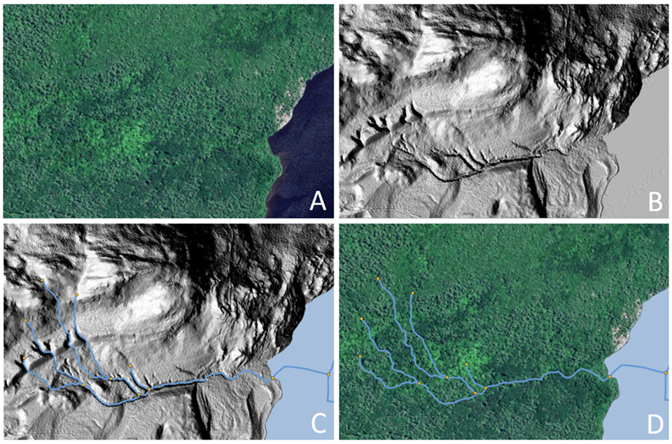
Four different maps showing the same area.
The map A on top left shows forest with part of a lake.
The map B on top right shows the elevation of the terrain with the digital terrain models.
The map C on the bottom left shows the automatically extracted features of the water lines in blue, their connection in an orange point on top of the elevation of the terrain.
The map D on the bottom right show the automatically extracted features of the water lines in blue, their connection in an orange point on top of a forest and the lake.
Acquiring and utilizing high-resolution lidar derived DTMs for the accurate extraction of hydrological features such as flow paths and channels is crucial. In certain conditions such as heavily forested areas, it can be virtually impossible to detect narrow channels in the terrain when utilizing imagery alone. With Lidar data the terrain under the tree canopy can be accurately estimated and these vital hydrographic features are usually revealed.
High-resolution optical imagery is also important for the extraction of open surface water. Lidar will often reflect directly off open water causing holes in the data, whereas this is not an issue with optical imagery.
Analysis-Ready Data
The CHN is designed to be ready for use in hydrological and hydraulic modelling by being correctly connected and including attributes that allow for full network traversing. Inspired by the United States Geological Survey’s (USGS) National Hydrography Dataset Plus High Resolution (NHDPlus HR), the CHN also incorporates value-added attributes (VAAs) such as stream order, catchment area and slopes. These pre-calculated network characteristics enhance the analysis readiness of the network.
Examples of modelling and analyses that the CHN can be used for:
- Flooding: determining potential flood extents in the Flood Hazard Identification and Mapping Program or for emergency management
- Transport fate: of sediment, nutrients, or other substances transported by surface water
- Climate / Environment: drought prediction and wildfire susceptibility
- Wildlife: habitat modelling, especially for aquatic species
- Water management: aiding urban planning, civil engineering, and conservation authorities
Streamlined Production, Maintenance, and Dissemination
Designed for efficiency, the CHN has six streamlined layers: flow paths, waterbodies, catchments, catchment aggregates, and work units. The production process is mainly automated, with ongoing efforts to minimize manual intervention in validation and correction.
The CHN is also produced and disseminated by hydrologically connected geographic areas called work units. Work units can contain just one watershed, several small adjacent watersheds that outlet into a large body of water, or be one of many parts of a larger watershed. Refer to the hydrographic networks webpage for a more details. In all cases, the features of a work unit are hydrologically connected. This is a more natural approach to data delivery, in comparison to data that is split into rectangular tiles. There are 1,338 work units across Canada, so a generalized work unit index file is provided in the downloads to help users decide which files to download.
Collaborative and Open Approach
The CHN project is designed to foster collaboration and openness in its creation. The CHN team collaborates with teams from CCMEO, the USGS, federal, Provincial and Territorial departments, and academia. Regular meetings with stakeholders ensure transparency and informed decision-making. The CHN team also embraces the use of open-source tools and share software, methods, and tools openly whenever possible.
Conclusion
The launch of the CHN marks an important moment in hydrographic data for Canada. With its commitment to be higher-resolution analysis-ready data, streamlined production, collaborative and open approach, the CHN is set to redefine the landscape of hydrographic data in Canada. The future of hydrography in Canada is the CHN: a network designed for precision, performance, and collaborative excellence.
You can find more information and updates on the Canadian Hydrospatial Network webpage.
Page details
- Date modified: