
Hydrographic Networks
Water is an important part of the Canadian landscape. It contains 20% of the world's total freshwater resources, and only 7% of which is considered renewable. To help with issues related to water management, Natural Resources Canada provides geospatial surface water data in the form of hydrographic networks. We also collaborate with the United States Geological Survey in cross-border harmonization efforts to offer a continuous network.
Available networks
Hydrographic or hydrospatial networks are datasets containing representations of surface water features. These features can include lakes, reservoirs, rivers, streams, islands, obstacles (e.g., waterfalls) and constructions (e.g., dams, wharves, dikes).
Natural Resources Canada maintains the following hydro networks:
.png)
This new and improved hydro network provides more opportunities to study how water flows and how it affects the environment. It is easier to use for analysis, more accurate and up-to-date.
With national coverage, this is our most complete network. It is available to be used in many applications such as cartographic display, hydraulic analysis, or as base data. The network was started in 2004 with many federal, provincial and territorial partners. It has not been maintained since 2022 but remains a popular dataset.
Highlights and differences between the networks
| Features | Canadian Hydrospatial Network | National Hydrographic Network |
|---|---|---|
| Follows Open Geospatial Consortium Hy-feature standards | ||
| Uses automatic extraction | ||
| Linear network including water flow direction | ||
| Based on high resolution data (where applicable) | ||
| Continuous national and international data | In progress | |
| Full ability to traverse network | ||
| Value-added attributes for hydrologic modelling including stream order(s) | ||
| Hierarchical layers of drainage area (catchment, drainage area, work unit) | ||
| Integration of hydrometric stations from Environment and Climate Change Canada | ||
| Attributes integrating elevation values (Z) | In progress | |
| Scale (best achieved, approximate) | 1:2,000 | 1:20,000 |
Importance of hydro networks
Hydro networks have many applications. For example, showing surface water features, and their place names, on a map is key for better spatial comprehension of the map. So the hydro networks are often used as a base layer in simple cartography, but also in more complex analyses. Here are some other examples of how hydro networks are used:
- Hydrologic and Hydraulic Modelling: networks can be used to model and understand water flow and drainage patterns.
- Environmental Analysis: scientists and technicians can use hydro networks to help with environmental analysis and monitoring.
- Decision-making Support: hydro networks can be used to aid in decision-making, including climate change mitigation, emergency management, and land-use planning.
Work Units – Areas of production and distribution of the networks
Natural Resources Canada’s hydrographic networks are produced and distributed by work units. Like watersheds, work units are different sizes and shapes as seen in Figure 1. They are created to represent different areas of the hydro network and can include different levels of sub-watersheds as seen in Figure 2. Like the surface water features, the work units change over time as data sources are updated.
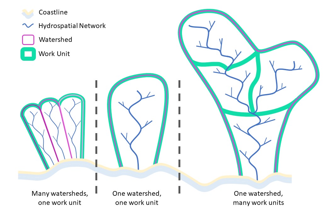
Figure 1 – Relationship between work units and watersheds: 3 scenarios.
Long description
A diagram showing the different types of work units possible.
The first section of the diagram shows a work unit in which there are many watersheds within a single work unit.
The second shows a single work unit containing a single watershed.
The third shows one watershed separated by many different work units.
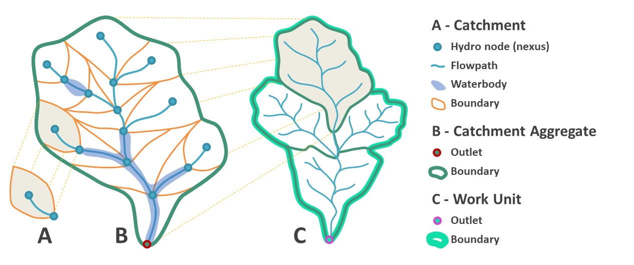
Figure 2 – Canadian Hydrospatial Network concept and their hierarchical relationships: Hydro node; Flowpath; Waterbody; Catchment; Catchment Aggregate; Work unit.
Long description
A diagram of the Canadian Hydrospatial Network concept and its hierarchal relationship.
The first part of the diagram, section A, shows the first part of the hierarchy, namely the hydro nodes, flowpath and waterbody.
The section B shows the catchment aggregate, which includes the outlet.
The section C shows the entire work unit, which includes section A and section B.
Here is some technical information about the work units:
- There are more than 1,338 work units covering the entire Canadian landmass.
- Each work unit is a simple polygon without holes.
- The work units form a continuous layer.
- The original work units were created from the Water Survey of Canada Sub-Sub-Drainage Area and Fundamental Drainage Areas of the Atlas of Canada. They have changed over time and may be different from the source boundaries.
As the new Canadian Hydrospatial Network is developed, its work unit boundaries do too. Their shape will differ slightly from the National Hydrographic Network work units since the Canadian Hydrospatial Network and source data varies from the National Hydro Network. The work unit boundaries are available for the Canadian Hydrospatial Network and the National Hydrographic Network.
Find out more
- Use the National Hydrographic Network ready-to-use map
- View the National Hydrographic Network documentation
- See the latest data announcements
- Read the frequently asked questions on geospatial data
- Learn about flood mapping
Contact us
For more information, contact geoinfo@nrcan-rncan.gc.ca.
Page details
- Date modified: