Language selection

Search


Flood Hazard Identification and Mapping Program

Flood Hazard Identification and Mapping Program - #FloodMapping

Our Indigenous engagement guidelines are now published!

The Indigenous engagement guidelines for flood mapping provide flood mapping professionals with guidance and information about engagement activities to help support their work in Indigenous engagement. These Guidelines provide a practical approach to initiating engagement and dialogue with Indigenous communities regarding flooding and mapping related activities in their area.

In Canada, many flood maps are not always available or up-to-date. Yet, flood hazard maps are essential to understanding a community’s risk to flooding. High quality flood mapping that is current and accessible will help governments, communities, and individuals understand flood hazards and to implement effective mitigation strategies to reduce the impacts of flooding.

That is why the Flood Hazard Identification and Mapping Program (FHIMP) is investing in updating Canada’s existing flood mapping capabilities. In partnership with provincial and territorial governments, the FHIMP aims to complete flood hazard maps of higher-risk areas in Canada and make this flood hazard information accessible. These maps will inform decision-making in support of land use planning, flood mitigation, adaptation to a changing climate, resilience building, and protection of lives and properties.

For more information about the program and the eligible activities, download our fact sheet.

FHIMP projects

Below is a list of active projects funded in part by FHIMP. Projects are grouped by activity type.

Number of Projects: 214
Last Updated: July 18, 2024

Province or territory Project name Activity type Status Location
Alberta Hinton - Flood Mapping Flood Mapping Completed Hinton
Alberta Vegreville - Flood Study Flood Mapping Completed Vegreville
Alberta Stettler - Flood Study Flood Mapping Completed Stettler
Alberta Red Deer County and Markerville - Flood Study Flood Mapping Completed Red Deer County
Alberta Manning - Flood Study Flood Mapping In Progress Manning
Alberta Grande Prairie - Flood Study Flood Mapping In Progress Grande Prairie
Alberta Paddle Prairie - Flood Study Flood Mapping In Progress Paddle Prairie
Alberta Ponoka - Flood Study Flood Mapping In Progress Ponoka
Alberta Watino - Flood Study Flood Mapping In Progress Watino
Alberta Lacombe - Flood Study Flood Mapping In Progress Lacombe
Alberta Lamont - Flood Study Flood Mapping In Progress Lamont
Alberta Millet - Flood Study Flood Mapping In Progress Millet
Alberta Kinuso - Flood Study Flood Mapping In Progress Kinuso
Alberta Alberta Spring 2024 LiDAR Acquisition - Robb, Peers, Edson, Chateh, and Carbon Data Acquisition Completed Carbon; Chateh; Edson; Peers; Robb
Alberta Alberta Fall 2024 LiDAR Acquisition - Rycroft, Thorsby, Two Hills, Crowsnest Pass, Birchwood Village Greens, and Lethbridge Data Acquisition In Progress Birchwood Village Greens; Crowsnest Pass; Lethbridge; Rycroft; Thorsby; Two Hills
Alberta Chateh - Flood Study Flood Mapping Completed Chateh
Alberta Carbon - Flood Study Flood Mapping Completed Carbon
Alberta Rycroft - Flood Study Flood Mapping In Progress Rycroft
Alberta Thorsby - Flood Study Flood Mapping In Progress Thorsby
Alberta Two Hills - Flood Study Flood Mapping In Progress Two Hills
Alberta Crowsnest Pass - Flood Study Flood Mapping In Progress Crowsnest Pass
Alberta Lethbridge - Flood Study Flood Mapping In Progress Lethbridge
Alberta Alberta Spring 2025 LiDAR Acquisition - Driftpile FN, Jarvie and Dapp, Sucker Creek FN, Barrhead, and East Prairie MS Data Acquisition Completed Barrhead; Driftpile; East Prairie River; Jarvie; Sucker Creek
Alberta Alberta Fall 2025 LiDAR Acquisition - Radway, Rosebud, Westward Ho, Nose and West Nose Creeks, Didsbury, and Eckville Data Acquisition Completed Didsbury; Eckville; Nose Creek; Radway; Rosebud; West Nose Creek; Westward Ho
Alberta Birchwood Village Greens - Flood Study Flood Mapping Completed Birchwood Village Greens
Alberta Driftpile - Flood Study Flood Mapping Completed Driftpile
Alberta Jarvie - Flood Study Flood Mapping Completed Jarvie
Alberta Radway - Flood Study Flood Mapping Completed Radway
Alberta Rosebud - Flood Study Flood Mapping Completed Rosebud
Alberta Westward Ho - Flood Study Flood Mapping Completed Westward Ho
Alberta Barrhead - Flood Study Flood Mapping In Progress Barrhead
Alberta Eckville - Flood Study Flood Mapping Completed Eckville
Alberta Didsbury - Flood Study Flood Mapping Completed Didsbury
Alberta Nose and West Nose Creek - Flood Study Flood Mapping Completed Calgary; Nose Creek; West Nose Creek
Alberta East Prairie River - Flood Study Flood Mapping Completed East Prairie River
British Columbia Upper Fraser-Nechako - Flood Mapping Flood Mapping In Progress Fraser River (Prince George); Nechako River
Manitoba Red River - Hydrodynamic Model Development and Flood Risk Mapping Flood Mapping In Progress Red River
Manitoba Little Saskatchewan - Hydrodynamic Model Development and Flood Risk Mapping Flood Mapping In Progress Little Saskatchewan River
Manitoba The Pas, Dauphin Lake Tributaries, Mantagao River, Fisher River, and Petersfield - Topographic Lidar Data Acquisition In Progress Dauphin Lake Tributaries; Mantagao River; Petersfield; Saskatchewan River Delta (East)
Manitoba La Salle River - Bathymetry Data Acquisition Completed La Salle River
New Brunswick Review of Historical Ice Jam Data Flood Mapping Closed
New Brunswick Review of Ice Observer Reports Flood Mapping In Progress
New Brunswick Flood Frequency Analysis for 8 Gauged Tributary Streams (Saint John River) Flood Mapping In Progress
New Brunswick Ice Jam Modeling ad Flood Hazard Mapping (Saint John River) Flood Mapping In Progress
New Brunswick Update of Current Flood Hazard Mapping (Sussex and Sussex Corner) Flood Mapping In Progress
New Brunswick New Brunswick Topo-Bathymetric LiDAR Collection 2024 Data Acquisition Completed
Newfoundland and Labrador Flood Hazard Mapping for Ferryland, Brigus, Heart’s Delight-Islington, Hant’s Harbour, and Winterton Flood Mapping In Progress Brigus; Ferryland; Hant's Harbour; Heart's Delight-Islington; Winterton
Newfoundland and Labrador SW Coast Flood Mapping Study for Codroy Valley and Southwest Coast of Newfoundland (Burgeo; Burnt Islands; Town of Channel and Port aux Basques; Codroy Valley; Isle aux Morts; Rose Blanche – Harbour le Cou) Flood Mapping In Progress Burgeo; Burnt Islands; Codroy; Ilse aux Morts; Rose Blanche - Harbour Le Cou; Town of Channel and Port aux Basques
Newfoundland and Labrador Topographic LiDAR over Stephenville, Kippens, Cox's Cove, Corner Brook, Codroy Valley, Channel-Port aux Basques, Burgeo, Ramea, Francois Data Acquisition Completed Burgeo; Codroy; Corner Brook & Cox's Cove; Francois; Parson's Pond; Ramea; Stephenville & Kippens; Town of Channel and Port aux Basques; Trout River
Newfoundland and Labrador West Coast Flood Hazard Mapping Study for Parson's Pond, Trout River, Corner Brook, Cox's Cove, Stephenville and Kippens Flood Mapping In Progress Corner Brook & Cox's Cove; Parson's Pond; Stephenville & Kippens; Trout River
Newfoundland and Labrador Topographic LiDAR for regions of Burin, Connaigre, Southern Avalon, Trinity Bay and Gander Loop Data Acquisition Completed Burin; Connaigre Peninsula; Gander; Southern Avalon Peninsula; Trinity Bay
Nova Scotia Gaspereau Watershed Detailed Flood Line Mapping - Phase 1 Flood Mapping Completed Town of Kentville; Town of Wolfville
Nova Scotia South-West Antigonish Watershed Detailed Flood Line Mapping - Phase 1 Flood Mapping Completed South-West Antigonish
Nova Scotia Eastern Shore Coastal Flood Modeling and Mapping - Phase 1 Flood Mapping In Progress Eastern Shore
Nova Scotia Review of Draft Reports by Client Engineer - Phase 1 & 2 Stuffing In Progress Annapolis; Eastern Shore; Meteghan Watershed; Sissiboo Bear; South-West Antigonish; Town of Kentville; Town of Wolfville
Nova Scotia Phase 1 - Value Added Work Flood Mapping In Progress
Nova Scotia Annapolis Primary Watershed - Phase 2 Flood Mapping In Progress Annapolis
Nova Scotia Halifax Regional Municipality Flood Hazard Mapping Flood Mapping Completed Halifax Regional Municipality
Nova Scotia Halifax Regional Municipality Data Collection Data Acquisition In Progress Halifax Regional Municipality
Nova Scotia Upper Fundy - Municipal Flood Line Mapping - Phase 2 Flood Mapping In Progress Kelly-Maccan-Hebert; Missaguash; Parrsboro; Tisdnish-Shinimicas
Nova Scotia Northumberland Region - Data Collection and Engagement - Phase 2 Flood Mapping In Progress Amherst; Colchester County; New Glasgow; Oxford; Pictou; Stellarton; Trenton; Westville
Nova Scotia Eastern Shore Region - Municipal Flood Line Mapping - Phase 2 Flood Mapping Completed Eastern Shore; Halifax Regional Municipality; Mulgrave; South-West Antigonish
Nova Scotia Minas Bassin Region - Municipal Flood Line Mapping - Phase 2 Flood Mapping In Progress Colchester County; Stewiacke; Truro
Nova Scotia Nova Scotia - Methodology Development for Regional Scale Flood Modeling for Watersheds in Nova Scotia Technical Guidance In Progress
Nova Scotia Program Coordinator Staffing In Progress
Northwest Territories Topographic LiDAR for Yellowknife, Aklavik, Fort Resolution and Jean Marie River Data Acquisition In Progress Aklavik; Fort Resolution; Jean Marie River; Yellowknife
Northwest Territories Data Acquisition and Support for 2022 Data Acquisition In Progress Aklavik; Hay River
Northwest Territories Aklavik, Fort Simpson, and Hay River - Preliminary Inundation Mapping Flood Mapping In Progress Aklavik; Fort Simpson ; Hay River
Northwest Territories Community Engagement and Data Acquisition for 2023 Data Acquisition In Progress Aklavik; Fort Good Hope; Fort Liard; Fort McPherson; Fort Resolution; Fort Simpson ; Hay River; Jean Marie River
Northwest Territories Finalization of Preliminary Inundation Maps for 3 Communities Flood Mapping In Progress Aklavik; Fort Simpson ; Hay River
Nunavut Imagery and elevation acquisition (Drone) - Iqualuit & Kimmirut Data Acquisition In Progress Iqaluit; Kimmirut
Nunavut Imagery and elevation acquisition (Drone) - Baker Lake, Coral Harbour, Chesterfield Inlet, Whale Cove Data Acquisition In Progress Baker Lake; Chesterfield Inlet; Coral Harbour; Whale Cove
Nunavut Imagery and elevation acquisition (Drone) - Arviat & Naujaat Data Acquisition In Progress Arviat; Naujaat
Nunavut Imagery and elevation acquisition (Drone) - Resolute Bay, Grise Fiord & Pond Inlet Data Acquisition In Progress Grise Fiord; Pond Inlet; Resolute
Nunavut Imagery and elevation acquisition (Drone) - Qikiqtarjuaq & Pangnirtung Data Acquisition In Progress Pangnirtung; Qikiqtarjuaq
Nunavut Imagery and elevation acquisition (Drone) - Clyde River & Arctic Bay Data Acquisition In Progress Arctic Bay; Clyde River (NU)
Ontario Topographic LiDAR for Eastern Ontario Conservation Authorities Data Acquisition In Progress Cataraqui Conservation Authority; Mississippi Valley Conservation Authority; Raisin Region Conservation Authority; Rideau Valley Conservation Authority; South Nation Conservation Authority
Ontario Topographic LiDAR for East Coast of Lake Huron and Georgian Bay Data Acquisition In Progress Georgian Bay - South Coast; Lake Huron - East Coast
Ontario Topographic LiDAR for the Georgian Bay area, Kawartha lakes, Sault-Ste-Marie, Sudbury, Thunder Bay Data Acquisition Completed Alliston; Bruce Peninsula; Kawartha Lakes; Manitoulin Island; Sault Ste. Marie; Sudbury; Thunder Bay
Ontario Toronto and Region Conservation Authority - 2023 Jurisdictional LiDAR Acquisition Data Acquisition In Progress Credit River Conservation Authority; Halton Conservation Authority; Lake Simcoe Conservation Authority; Toronto Regional Conservation Authority
Ontario Topographic LiDAR for Chapleau, Timmins, Sudbury, Rainy River, and Northeastern Ontario Data Acquisition Completed Chapleau; Rainy River; Sudbury; Timmins
Ontario Niagara Peninsula Conservation Authority - Coyle Creek and Draper's Creek Floodplain Mapping Flood Mapping Completed Coyle Creek; Draper's Creek
Ontario Niagara Peninsula Conservation Authority - Oswego Creek Floodplain Mapping Flood Mapping Completed Oswego Creek
Ontario Central Lake Ontario Conservation Authority - Lynde Creek Floodplain Mapping Flood Mapping In Progress Lynde Creek
Ontario Municipality of Trent Lakes - Nogies Creek Flood Plain Mapping Study Flood Mapping Completed Nogies Creek
Ontario Municipality of Trent Lakes - Miskwaa Ziibi River Flood Plain Mapping Study Flood Mapping In Progress Miskwaa Ziibi River
Ontario Lower Trent Conservation - Floodplain Mapping for Mayhew Creek - Trenton - 2 Zone Update; Floodplain Mapping for Cold Creek - Frankford - 2-Zone Update Flood Mapping Completed Cold Creek; Mayhew Creek
Ontario The Corporation of the Municipality of Huron Shores - Floodplain Mapping in Huron Shores Flood Mapping In Progress Huron Shores
Ontario City of Ottawa - Flood Mapping in the Bear Brook Watershed Flood Mapping Completed Bear Brook Watershed
Ontario City of Ottawa - Flood Mapping in the Castor River Watershed Flood Mapping In Progress Castor River Watershed
Ontario South Nation Conservation - Flood Mapping in the South Branch of the South Nation River Flood Mapping In Progress South Branch of the South Nation River
Ontario City of Orillia - Flood Plain Mapping Update Flood Mapping Completed Orillia
Ontario Lower Trent Conservation - Floodplain Mapping for Colborne Creek - Town of Colborne Flood Mapping Completed Colborne Creek
Ontario City of Kitchener - Topographic and Bathymetric Survey of Watercourse Cross-sections and Hydraulic Structures in the City of Kitchener Data Acquisition Completed Kitchener
Ontario Corporation of the County of Essex - Essex Region Coastal Flood Hazard Mapping and Data Sharing Project Flood Mapping In Progress City of Windsor; County of Essex
Ontario South Nation Conservation - Land Cover Update in Eastern Ontario Data Acquisition In Progress Eastern Ontario
Ontario Raisin Region Conservation Authority - Eastman Drain Flood Mapping Flood Mapping Closed Eastman Drain
Ontario Toronto and Region Conservation Authority - Frenchman's Bay Watershed Hydrology and Flood Plain Mapping Update Flood Mapping In Progress Frenchman's Bay
Ontario Halton Region Conservation Authority - Bronte Creek Watershed - Structure Survey Data Acquisition In Progress Bronte Creek
Ontario MNRF Policy Advisors Staffing In Progress
Ontario Rideau Valley Conservation Authority - Rideau Lakes Flood Risk Mapping Flood Mapping In Progress Big Rideau Lake - Portland; Bobs Lake; Lower Rideau Lake; Otty Lake - Jebbs Creek
Ontario Rideau Valley Conservation Authority - City Flood Mapping Program Flood Mapping In Progress Brassils Creek; Flowing Creek; Graham Creek; Greens Creek; Sawmill Creek; Stillwater
Ontario Catfish Creek Conservation Authority - 2022 CCCA Port Bruce Riverine Floodplain Mapping and Coastal Floodproofing Flood Mapping In Progress Port Bruce
Ontario Cataraqui Region Conservation Authority - St. Lawrence River Flood Hazard Mapping Project Flood Mapping In Progress St. Lawrence River
Ontario Quinte Region Conservation Authority - Consecon Lake and Creek Flood Hazard mapping update Flood Mapping Completed Consecon Lake
Ontario Quinte Region Conservation Authority - Napanee River Upper Lakes Floodplain Mapping Study Flood Mapping Completed Napanee River Upper Lakes
Ontario Quinte Region Conservation Authority - Selby Creek Floodplain Mapping Update Flood Mapping Completed Selby Creek (Sucker Creek)
Ontario Quinte Region Conservation Authority - Salmon River Upper Lakes Floodplain Mapping Study Flood Mapping In Progress Salmon River Upper Lakes
Ontario Quinte Region Conservation Authority - Salmon and Napanee Rivers Crossings and In-Line Structures Surveys Data Acquisition Completed Napanee River; Salmon River
Ontario City of Barrie - Update Barrie Creeks Drainage Modelling & Digital Flood Mapping in Consideration of Climate Change Flood Mapping In Progress Barrie
Ontario Township of Ramara - Update Lake St. John Flooding Map Flood Mapping In Progress Lake St. John
Ontario Maitland Valley Conservation Authority - North Perth Floodplain Mapping Update Flood Mapping In Progress North Perth
Ontario North Bay-Mattawa Conservation Authority - Lansdowne Creek Floodplain Mapping Project Flood Mapping Completed North Bay-Mattawa
Ontario County of Haliburton - Haliburton Floodplain Mapping Project Flood Mapping Completed Burnt River; Gull River
Ontario Matawa First Nations Management - Flood Hazard Identification and Mapping of Matawa Member Communities Flood Mapping In Progress
Ontario County of Renfrew - Renfrew County Flood Mapping for Ottawa River and Bonnechere River Prioritization In Progress Renfrew County
Ontario Long Point Region Conservation Authority - Long Point Region Flood Hydrology Study Flood Mapping In Progress Long Point Region
Ontario Kettle Creek Conservation Authority - KCCA Watershed Enhanced Riverine Floodplain Mapping Flood Mapping In Progress Kettle Creek
Ontario Municipality of Muskoka - Flood Plain Mapping in the Muskoka River Watershed Flood Mapping In Progress Brunel; Central Gravenhurst; Northern Haliburton; Northern Huntsville; Northern Lake of Bays; Southern Lake of Bays; Utterson; West Gravenhurst
Ontario Saugeen Valley Conservation Authority - Flood Hazard Mapping, Municipality of West Grey, the Town of Saugeen Shores, and the Township of Huron-Kinloss Flood Mapping In Progress Clark Creek; Durham Creek; Pine River; Saugeen River
Ontario Crowe Valley Conservation Authority - Chandos Lake Flood Hazard Identification and Mapping Flood Mapping In Progress Chandos Lake
Ontario Crowe Valley Conservation Authority - Crowe River Flood Hazard Identification and Mapping Flood Mapping In Progress Crowe River
Ontario Technical Guidance - Flood Hazard Identification and Priority Setting Technical Guidance In Progress
Ontario Niagara Peninsula Conservation Authority (ref#ON22-001) Flood Mapping Completed Coyle Creek; Draper's Creek
Ontario Niagara Peninsula Conservation Authority - Oswego Creek Floodplain Mapping (ref: ON22-002) Flood Mapping Completed Oswego Creek
Ontario Central Lake Ontario Conservation Authority - Lynde Creek Floodplain Mapping (ref: ON22-005) Flood Mapping In Progress Lynde Creek
Ontario City of Orillia - Flood Plain Mapping Update (ref: ON22-014) Flood Mapping Completed Orillia
Ontario Hamilton Conservation Authority - Red Hill Creek Flood Plain Mapping Study (ref: ON22-029) Flood Mapping Completed Red Hill Creek
Ontario Otonabee Conservation Area - Byersville Creek Floodplain Mapping Project (ref: ON22-034) Flood Mapping In Progress Byersville
Prince Edward Island Improving Coastal Flood Hazard Maps for Prince Edward Island (Coastal Flood Depth Layer) Flood Mapping In Progress Prince Edward Island
Prince Edward Island Pluvial Flood Hazard Mapping and Modelling Flood Mapping Closed
Prince Edward Island Pluvial Flood Hazard Mapping and Modelling - In-house support Administrative and Engagement In Progress Prince Edward Island
Prince Edward Island Flood Hazard Map Education and Training - In-house support Administrative and Engagement In Progress
Quebec LiDAR topographique (2021-2022) pour les rivières Gatineau, de la Lièvre, Saint-Maurice, Yamaska et Châteauguay Data Acquisition In Progress Rivière Chateauguay; Rivière Gatineau; Rivière Petite Nation; Rivière Saint-Maurice; Rivière Yamaska; Rivière Yamaska Nord
Quebec Coordination et suivi de l'entente Administrative In Progress
Quebec LiDAR topographique (2022-2023) pour les rivières Petite-Nation, L'Assomption et Richelieu Data Acquisition In Progress Rivière Petite Nation; Rivière aux Brochets; Rivière l'Assomption
Quebec LiDAR topo-bathymétrique (2022-2023) sur des portions des rivières Kinojévis, L’Assomption, Maskinongé, du Loup et Yamaska Data Acquisition In Progress Rivière Kinojévis; Rivière Maskinongé; Rivière Yamaska Nord; Rivière du Loup; Rivière l'Assomption
Quebec LiDAR topo-bathymetrique (2022-2023) sur des portions des rivières Nicolet, Bécancour, du Sud et Chaudière Data Acquisition In Progress Rivière Bécancour; Rivière Chaudière; Rivière Nicolet; Rivière du Sud
Quebec Québec multiples rivières - Acquisition de données terrain (jaugeages, bathymétrie et lignes d'eau) Data Acquisition In Progress Rivière Etchemin; Rivière Jacques Cartier; Rivière Matane; Rivière Monmorency (Sud); Rivière Nicolet; Rivière Ouiatchouan; Rivière Ristigouche; Rivière Saint-Maurice; Rivière Sainte-Anne; Rivière au Renard; Rivière aux Brochets; Rivière du Gouffre; Rivière du Loup; Rivière du Nord; Rivière l'Assomption
Quebec Fleuve Saint-Laurent - Modélisation hydrodynamique d’événement de crues du fleuve Saint-Laurent (collaboration ECCC) Flood Mapping In Progress Fleuve Saint-Laurent
Quebec Rivières Assomption – Modélisation hydraulique de tronçons de rivières Flood Mapping In Progress Rivière Mitis; Rivière Rigaud; Rivière Saint-Jean
Quebec LiDAR topographique (2023-2024) pour les rivières Outaouais, Blanche, Maskinongé, Nicolet, Bécancour (phase 1) Data Acquisition In Progress Rivière Bécancour; Rivière Maskinongé; Rivière Nicolet; Rivière des Outaouais (Nord)
Quebec LiDAR topographique (2023-2024) pour les rivières Montmorency, Cascapédia (Petite), Saguenay, Chicoutimi, Ha! Ha! (Phase 1) Data Acquisition Completed Rivière Cascapédia; Rivière Ha! Ha! (Sud); Rivière Monmorency (Sud); Rivière Saguenay
Quebec LiDAR topo-bathymétrique (2023-2024) pour les rivières Gatineau, du Nord, Châteauguay, Yamaska, St-François, du Nord et Ste-Anne (Phase 1) Data Acquisition In Progress Rivière Gatineau; Rivière Sainte-Anne; Rivière du Nord
Quebec Projet de recherche et analyse de levés LiDAR topo-bathymétriques - Université de Sherbrooke et Université Laval Research In Progress Fleuve Saint-Laurent; Rivière Batiscan; Rivière Chaudière; Rivière Saguenay; Rivière Saint-Jean; Rivière Sainte-Anne
Quebec LiDAR topographique dans la Communauté Métropolitaine de Montréal (Phase 1) Data Acquisition In Progress Montréal
Quebec Lidar topographique pour les rivières St-François et Blanche Data Acquisition In Progress Rivière Blanche; Rivière Saint-François
Quebec LiDAR topo-bathymétrique (2023-2024) pour les rivières Gatineau, du Nord, Châteauguay, Yamaska, St-François, du Nord et Ste-Anne (Phase 2) Data Acquisition Completed Rivière Chateauguay; Rivière Saint-François; Rivière Yamaska
Saskatchewan Topo-bathymetric LiDAR for North & South Saskatchewan Rivers (Option 1) Data Acquisition Completed North Saskatchewan River; South Saskatchewan River (Saskatoon to Duck Lake)
Saskatchewan Topo-bathymetric LiDAR for North & South Saskatchewan Rivers (Option 3) Data Acquisition In Progress North Saskatchewan River; South Saskatchewan River (Saskatoon to Duck Lake)
Saskatchewan Topographic LiDAR (2022-23) over Swift Current, Meota, Saskatoon, South Sask River, Meeting Lake and Cumberland House Data Acquisition In Progress Cumberland House; Meeting Lake; RM of Meota; Saskatoon; South Saskatchewan River (Alberta to Eston); Swift Current
Saskatchewan Topographic LiDAR (2023-24) over Mervin, Wood River, Beaver River, Radville and Buffalo Narrows Data Acquisition In Progress Beaver River; Buffalo Narrows; Gravelbourg; RM of Mervin; Radville
Saskatchewan Climate Change in Closed-Basin Lakes Research Initiative Research In Progress
Saskatchewan Cumberland House - Survey Data Collection Data Acquisition In Progress Cumberland House
Saskatchewan Cumberland House - Flood Hazard Mapping Flood Mapping In Progress Cumberland House
Saskatchewan Île-à-la-Crosse - Flood Hazard Mapping Flood Mapping In Progress Île-à-la-Crosse
Saskatchewan Île-à-la-Crosse - Stakeholder Engagem Dissemination and Engagement In Progress Île-à-la-Crosse
Saskatchewan Regina - Survey Data Collection Data Acquisition In Progress Regina
Saskatchewan Regina - Flood Hazard Mapping Flood Mapping In Progress Regina
Saskatchewan Regina - Stakeholder Engagement Dissemination and Engagement In Progress Regina
Saskatchewan Tisdale - Survey Data Collection Data Acquisition In Progress Tisdale
Saskatchewan Tisdale - Flood Hazard Mapping Flood Mapping Completed Tisdale
Saskatchewan Tisdale - Stakeholder Engagement Dissemination and Engagement Completed Tisdale
Saskatchewan Melfort - Survey Data Collection Data Acquisition In Progress Melfort
Saskatchewan Saskatoon - Stakeholder Engagement Dissemination and Engagement Completed Saskatoon
Saskatchewan Weyburn - Survey Data Collection Data Acquisition Completed Weyburn
Saskatchewan Weyburn - Stakeholder Engagement Dissemination and Engagement Completed Weyburn
Saskatchewan Lebret Flood - Stakeholder Engagement Dissemination and Engagement Completed Lebret
Saskatchewan Maple creek - Stakeholder Engagement Dissemination and Engagement Completed Maple creek
Saskatchewan Melville - Stakeholder Engagement Dissemination and Engagement Completed Melville
Saskatchewan Swift Current - Survey Data Collection Data Acquisition Completed Swift Current
Saskatchewan Swift Current - Flood Hazard Mapping Flood Mapping Completed Swift Current
Saskatchewan Swift Current - Stakeholder Engagement Dissemination and Engagement Completed Swift Current
Saskatchewan Rural Municipality of Meota - Survey Data Collection Data Acquisition Completed RM of Meota
Saskatchewan Rural Municipality of Meota - Flood Hazard Mapping Flood Mapping Completed RM of Meota
Saskatchewan Rural Municipality of Meota - Stakeholder Engagement Dissemination and Engagement In Progress RM of Meota
Saskatchewan Gravelbourg - Survey Data Collection Data Acquisition In Progress Gravelbourg
Saskatchewan Gravelbourg - Flood Hazard Mapping Flood Mapping In Progress Gravelbourg
Saskatchewan Gravelbourg - Stakeholder Engagement Dissemination and Engagement In Progress Gravelbourg
Saskatchewan Lumsden - Survey Data Collection Data Acquisition Completed Lumsden
Saskatchewan Lumsden - Flood Hazard Mapping Flood Mapping In Progress Lumsden
Saskatchewan Lumsden - Stakeholder Engagement Dissemination and Engagement Completed Lumsden
Saskatchewan Fort Qu'Appelle - Survey Data Collection Data Acquisition In Progress Fort Qu'Appelle
Saskatchewan Fort Qu'Appelle - Stakeholder Engagement Dissemination and Engagement In Progress Fort Qu'Appelle
Saskatchewan Moose Jaw - Survey Data Collection Data Acquisition In Progress Moose Jaw
Saskatchewan Term Staff - Flood Hazard Mapping Staffing In Progress
Saskatchewan Term Staff - Stakeholder Engagement Staffing In Progress
Saskatchewan Term Staff - Research Initiative Staffing In Progress
Saskatchewan Planet Subscription Other Completed
Saskatchewan Flood Vulnerability Assessment and Prioritization Study Flood Mapping Completed
Saskatchewan Saskatchewan Guidelines Review Technical Guidance Completed
Saskatchewan Whitesand River - LiDAR Acquisition Data Acquisition Completed Whitesand River
Saskatchewan Whitesand River - Data Collection Data Acquisition In Progress Whitesand River
Saskatchewan Vanguard - Data Collection Data Acquisition Completed Vanguard
Yukon Southern Lakes - Flood Mapping Flood Mapping Completed Carcross; Lake Laberge; Marsh Lake; Tagish
Yukon Southern Lakes - Lidar Acquisition Survey Data Acquisition In Progress Lake Laberge; Marsh Lake; Tagish
Yukon Carmacks, Dawson City, Klondike Valley, Mayo, Ross River, Old Crow, Upper Liard, Whitehorse - GCP Survey Data Acquisition Completed Carmacks; Dawson City; Klondike Valley; Mayo; Old Crow; Ross River; Upper Liard; Whitehorse
Yukon Carmacks - Engagement (Community Events) Dissemination and Engagement In Progress Carmacks
Yukon Southern Lakes - Engagement (Community Events) Dissemination and Engagement Completed Carcross; Lake Laberge; Marsh Lake; Tagish
Yukon Teslin - Flood Mapping Flood Mapping Completed Teslin
Yukon Teslin - GCP Survey Data Acquisition Completed Teslin
Yukon Carmacks & Teslin - LiDAR Processing Data Acquisition Closed Carmacks; Teslin
Yukon Staff - Flood Mapping Project Manager Staffing Completed
Yukon YukonU Advising Support Staffing Closed
Yukon Carcross - GCP Survey (Lidar Correction) Data Acquisition In Progress Carcross
Yukon Southern Lakes - Engagement (CTFN, KDFN Committee Participation) Dissemination and Engagement In Progress Carcross; Lake Laberge; Marsh Lake; Tagish
Yukon Teslin - GCP Survey (Lidar Correction) Data Acquisition In Progress Teslin
Yukon Old Crow - Flood Mapping Flood Mapping In Progress
Yukon Dawson City and Klondike Valley - Flood Mapping Flood Mapping In Progress Dawson City; Klondike Valley
Yukon Mayo - GCP Survey Data Acquisition Completed Mayo
Yukon YukonU - Break-up Modelling (Old Crow, Dawson City, Klondike Valley) Flood Mapping In Progress Dawson City; Klondike Valley; Old Crow
Yukon Engagement - 2024 Studies Dissemination and Engagement In Progress
Yukon Engagement - Illustrations Dissemination and Engagement In Progress
Yukon Engagement - Staff Travel (2024 Studies) Dissemination and Engagement In Progress

(Project names are in the language of the region and could not be translated.)


About the program

Under the National Adaptation Strategy, the Government of Canada is investing $164.2M (2024 to 2028) in its FHIMP to help Canadians better plan and prepare for future floods. The original FHIMP investment totalled $63.8 million over three years (2021 to 2024).

FHIMP is one of many measures the Government of Canada is pursuing with a view to increasing the resiliency of Canadians in the face of the rising frequency and costs of flood events and other climate-related disasters. These efforts avoid duplication of other federal flood mapping activities, such as First Nation Adapt. The FHIMP is complementary to initiatives including:

Program eligibility

Provincial and territorial governments are the eligible recipients for funding under the FHIMP. However, they may collaborate with, and redistribute funding to eligible entities, such as:

  • municipal or other local governments
  • public sector bodies
  • private sector bodies
  • Indigenous communities
  • international non-government organizations, or
  • any combination of these entities

Historic flood programs

Text version

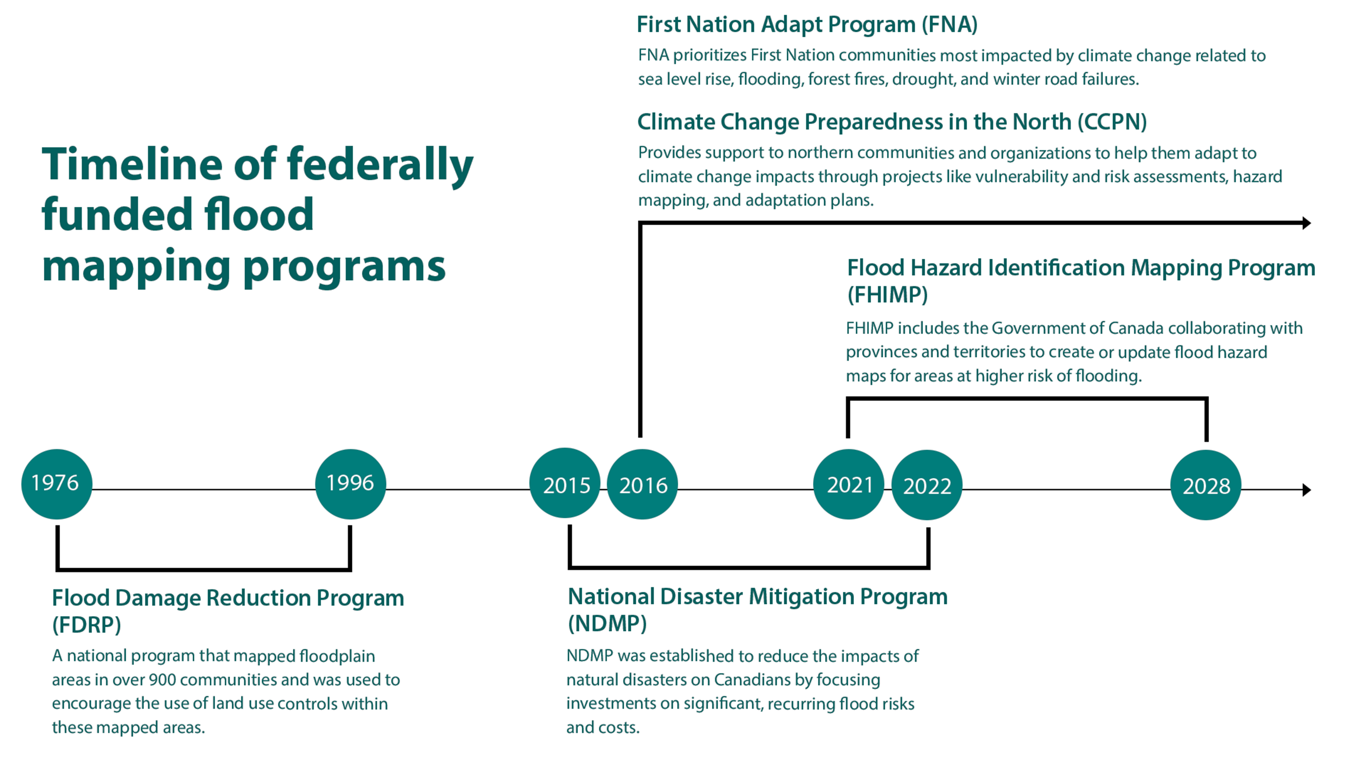
A timeline demonstrating the years different Flood-related programs have been active with brief descriptions.

  • From 1976 until 1996, the Flood Damage Reduction Program (FDRP) was in place. It was a national program that created flood maps in over 900 communities and was used to encourage the use of land-use controls within these mapped areas.
  • From 2016 onward, the First Nations Adapt Program (FNA) funds adaptation activities for First Nation communities south of 60 who are greatly impacted by climate change. The program provides support for community-led, needs-based, adaptation projects like risk assessments, cost benefit analysis of adaptation options, and flood mapping.
  • From 2016 onward, the Climate Change Preparedness in the North (CCPN) program provides support to northern communities and organizations to help them adapt to climate change impacts through projects like vulnerability and risk assessments, hazard mapping, and adaptation plans.
  • From 2015 until 2022, the National Disaster Mitigation Program (NDMP) was established to reduce the impacts of natural disasters on Canadians by focusing investments on significant, recurring flood risks and costs. The four streams of funding included development/modernization of flood maps.
  • From 2021 until 2028, the Flood Hazard Identification and Mapping Program (FHIMP) will be active. The program includes collaborating with provinces and territories to create or update flood hazard maps for areas at higher risk of flooding.


Find out more about flood mapping

Reach out to us

For more information, please email geoinfo@nrcan-rncan.gc.ca

Page details

Date modified: