Tracking forest change and recovery in Canada
Forests are in a constant state of change
Canada’s forests, like all forests in the world, change constantly.
Disturbances by wildland fire and forest insects and diseases, for example, are a natural part of forest life cycles. Human activities, such as resource development, also shape forests over time. Occasionally, those activities lead to permanent forest clearing (deforestation), but for the vast majority of forests, clearing is temporary, with vegetation recovering naturally or with human assistance.
Keeping track of forest change and recovery is a fundamental part of Canada’s commitment to forest stewardship and sustainable forest management.
Remote sensing technologies track forest change and recovery
With a range of remote sensing technologies, Canada’s forest analysts and resource managers compile large amounts of data about the country’s forests – such as forest cover extent, species composition, disturbance, forest health and other factors. Innovative processing technologies transform these data into highly detailed maps, images and other forms of visual display, as well as into useful information products that support forest science and management.
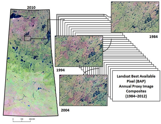
National image composites produced from Landsat surface reflectance images during the 28-year period from 1984 to 2012 are, for example, providing an invaluable archive of forest disturbance and recovery rates in Canada's forests over time.
Using image composites to characterize annual changes in forest cover and condition
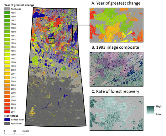
The sample maps below show how the 1984–2012 time series of composite images enables the spatial extent of forest cover change in Saskatchewan to be characterized.
Wildland fire is the main cause of forest disturbance in the province, and tracking the forest cover changes year over year shows that areas burned are recovering.

Larger image [169 Kb JPG]
Combining and analyzing a stack of Landsat image composites reveals two types of forest cover changes: those resulting from stand-replacing disturbances (e.g., wildland fires, harvesting or road construction) and those resulting from more subtle shifts in vegetation condition (e.g., from moisture stress or defoliation). With a time series like this, forest analysts can also tell the rate at which forests are being re-established in these areas.

Larger image [180 Kb JPG]
These composite maps show: (A) the year of greatest change in forest cover over the period considered; (B) an example of a Landsat image composite for 1993; and (C) the rate of recovery for disturbed forest (the sample area shows stands with high and low rates of vegetation recovery).
Why does recovery of forest cover vary?
Forest harvesting in managed forests in Canada typically occurs on productive sites. At these locations, recovery following harvesting is usually uniform and rapid, through natural regeneration or site planting or reseeding. In areas subject to wildland fire, a wide range of forest conditions and other land cover types can be impacted. In these areas, recovery following fire disturbance is usually more variable and often takes longer to occur.
Rates of recovery also vary temporally. They are usually greatest in the period immediately following a disturbance event such as fire. This increased rate of recovery is related to the flush of herbaceous vegetation that typically follows a wildland fire event. That flush is a precursor to the return and re-establishment of trees, which occur more gradually over a number of years following the fire.
Learn more about forest dynamics and post-disturbance recovery
Natural disturbances are particularly important in supporting the cycle of regeneration and regrowth in boreal forests. Find out why forests need fires, insects and diseases.
- Pixel-Based Image Compositing for Large-Area Dense Time Series Applications and Science
- An Integrated Landsat Time Series Protocol for Change Detection and Generation of Annual Gap-Free Surface Reflectance Composites
- Characterizing Residual Structure and Forest Recovery Following High-Severity Fire Using Landsat Time Series and Airborne LiDAR Data
- Forest Monitoring Using Landsat Time Series Data
Page details
- Date modified: