
Revolutionizing forest monitoring and management in Canada
Today, nearly every industry, service sector and other area of activity is well into a “data revolution.”
The ways data are being collected, channelled and applied are profoundly affecting how everyone, from individuals to governments and businesses, gets information and uses it. Technologies that once rested in the realm of science fiction—like satellite data instantaneously beamed to Earth, mapped and ready to read on hand-held phones and dashboard displays—are now mainstream.
Canada’s forest sector is taking advantage of these radical developments and contributing its own innovations.
With new remote sensing technologies, massive amounts of data are being collected more quickly and consistently than ever before imagined. Sophisticated sensors mounted on satellites, planes, helicopters and even drones (or UAVs – unmanned air vehicles) have made data collection over Canada’s vast and dynamic forests not only more efficient and cost-effective, but more comprehensive. In turn, equally innovative processing and analysis technologies are transforming these data into highly detailed maps, images and other forms of visual display.
In the Information Age, this technology-fuelled data revolution has also made it easier for everyone—not just foresters, scientists and technicians—to watch over Canada’s forests. That’s a good thing. More information, backed with on-the-ground knowledge, helps support better forest monitoring, better prediction making, and better management decision making. And the more we are learning, the more we are seeing opportunities for optimizing and increasing the many benefits that forests provide Canadians.
The importance of tracking how and why forests change
Forests are always changing, and keeping a close eye on the changes underway in Canada is a fundamental part of this country’s commitment to forest stewardship and sustainable forest management.
Collecting information at regular intervals—about the extent of forest cover, species composition, disturbances, forest health and other factors—gives analysts a means of identifying trends and patterns of change, and of understanding the reasons for and implications of those changes. This access to greater knowledge is enhancing forest management in so many ways. Our ability to predict coming changes is improved, and therefore so is our capacity to make ever better-informed operational decisions on the ground.
Why do forests change?
Most changes in forests occur over predictable seasonal and life cycles. Disturbances by wildland fire and insects, for example, are a natural part of forest life cycles. Human activities also shape forests over time. Sometimes those activities lead to permanent forest clearing (deforestation). Other times, the clearing is temporary, with forest vegetation left to regenerate naturally or with human assistance.
Major advances in remote sensing are giving forest scientists, resource managers and policy-makers improved insight into how and why Canada’s forests change.
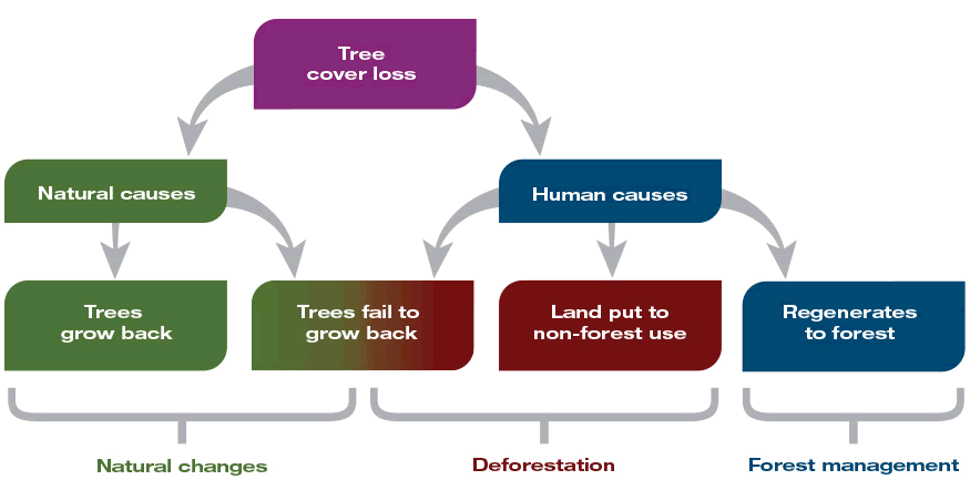
Tree cover loss results from natural causes (wildland fire, insects) and human causes (harvesting, land clearing). The proportion of area that regenerates back to forests differs greatly between regions and by cause of disturbance.
Long description
- Diagram shows that tree cover loss is the result of both natural causes and human causes. Where tree cover loss is the result of natural causes, such as wildland fire or insect damage, it’s considered a natural change whether or not the trees grow back. Where tree cover loss is the result of human causes, it’s considered deforestation if the trees fail to grow back, or if the land is put to non-forest use. Where human activities cause tree cover loss that is temporary (land regenerates to forest), it is considered forest management.
Source
- Diagram and caption adapted from Kurz, W.A. 2010. An ecosystem context for global gross forest cover loss estimates (Commentary), Proceedings of the National Academy of Sciences: 107 (20): 9025–9026, DOI: 10.1073/pnas.1004508107.
Remote sensing and data processing: Powerful tools in the forest monitoring kit
Remote sensing, the art and science of observing things from afar, is not new. Foresters, like other resource managers, have long used aircraft (like planes and helicopters) to get pictures of landscapes from above. Over the years, however, technological innovation has substantially expanded and refined the tools available for foresters to use. Remote sensing via satellite is standard practice now.
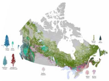
The map Forest Composition across Canada was produced by using satellite-based technology. In this case, NRCan–CFS combined information from the National Forest Inventory with imagery collected by the MODIS instrument aboard NASA’s Terra satellite.
Satellite imaging has proven to be especially valuable in monitoring Canada’s large, remote boreal forests, where traditional ground- and air-based approaches are impractical and prohibitively expensive.
Satellites orbit Earth constantly, collecting gigabytes-worth of digital data about the world’s forests. Sifting through the data captured and stored in massive data warehouses is the job of remote sensing scientists who use custom-made software running on powerful computers.
Most of the data are being collected by international research partnerships and shared widely. Canada’s forest scientists—at Natural Resources Canada–Canadian Forest Service (NRCan–CFS), universities and other research agencies—collaborate on many projects with other research organizations around the world to study what the data are revealing about forest characteristics, both across this country and globally. Satellite data are being used, for instance, to measure vegetation productivity and to map forest cover and forest disturbance.
Careful interpretation: Essential to making sense of monitoring data
Have these remote sensing advances made ground- and air-based data collection technologies unnecessary? Not at all. It’s one thing to observe changes in forest cover. It’s another to understand what those changes really indicate and why they are taking place. Even high-resolution images of the quality now being produced from satellite data cannot by themselves explain what is being shown. Interpreting the images accurately requires “boots on the ground” to verify what those “eyes in the sky” are seeing. It takes scientific and technical expertise about forest ecosystems, natural processes and local conditions to accurately interpret the data.
This is certainly the case with monitoring rates of deforestation, a matter of global concern. While forest cover loss may be apparent from satellite imagery, knowledgeable interpretation is required to truly understand how and why that loss occurred. Not all forest cover loss means there is deforestation (meaning permanent change of forests to new, non-forest land uses).
Only by distinguishing between natural- and human-caused change, understanding the nature of the disturbance observed, and knowing forest recovery rates can analysts make reasonable assessments of deforestation rates in any region. It is through such assessments, for example, that analysts know that Canada’s annual deforestation rates have been declining for the past two decades. Today, less than 0.02% of Canada’s forest lands are deforested each year.
Better data are enabling better-informed and more effective policy-making
At the global level, satellite data are helping forest analysts more accurately characterize changes in forest cover, assess how forest cover changes are affecting ecosystem services (such as water filtering), and quantify rates of deforestation and afforestation. For example, such data are being used across Canada to:
Monitor wildland fire occurrence and spread:
- Real-time tracking of daily fire activity is being used in wildland fire management programs, plans and prediction software in support of fire suppression decision making.
- Detailed mapping of burned areas is being used to analyze fire impacts.
Monitor forest cover type and forest cover extent:
- Forest cover data from the National Forest Inventory are being combined with satellite data to produce detailed national maps of forest attributes such as volume, species and height.
- Information is being used in research to study the effects of climate change on forests and to develop predictions.
Canadian scientists are also collaborating with others around the world to develop new data products (such as mapping programs and interpretive applications) to help monitor forests globally. At the same time, researchers in Canada are developing approaches specific to the study of forests in this country. For instance, international scientific teams are developing global maps of forest cover change. Canadian scientists are developing more detailed maps and using these to study why the changes observed by global monitoring programs have occurred.
The view ahead: Improving our ability to predict changes in forest cover
The more that is understood about how and why Canada’s forests are changing, the better prepared researchers and forest managers will be in adapting to all the other changes going on: in the forest products Canada turns out, in the global market demand for those products, and in the public expectations about what constitutes good forest stewardship.
In so many ways, the new data-strengthened tools in use are significantly enhancing the day-to-day experience of forest management, and not just as applied to forest cover monitoring.
Multiple databases used together offer tremendous potential for numerous aspects of forest resource planning and management. For example, integrated systems are already in use for predicting wildland fire-fighting resource demands. The approach draws on a combination of hefty databases: weather, forest cover, terrain, fire behaviour and more. The result—a full-scope situational snapshot—offers managers substantial support in making sound, time-sensitive deployment decisions about wildland fire-fighting equipment and personnel resources.
Many more applications of the data being gathered by remote sensing are also now being developed. In the future, for instance, it is hoped that forest pest infestation and host tree distribution mapping will enable early detection of pests and prediction of potential outbreaks and likely patterns of spread.
With the data revolution underway in the forest sector, it’s also an exciting time for resource managers, scientists and others committed to the responsible development of this country’s valuable and extensive forest resources—resources vital in both the national interest and the global interest.