
Canadian Hydrospatial Network
Looking for Canadian Hydrospatial Network data and documentation? Access it on Open Government.
The Canadian Hydrospatial Network (CHN) is a geospatial data product that represents Canada’s surface water features – lakes, rivers, watersheds and more – and the connections between them.
The CHN provides a unique vantage point to explore how surface water features interrelate, impacting people, infrastructure, plants, animals, and the environment. Its versatile applications include:
- Hydrologic and Hydraulic Modeling: serving as a foundation for advanced hydrologic and hydraulic modeling, and other analyses.
- Water and Watershed Management: offering data to aid water and watershed management.
- Understanding Water-related Phenomena: facilitating in-depth insights into water-related phenomena, from flooding to drought.
- Cartographic Foundation: providing essential base data for cartography.
Improvements and advancements
The CHN, developed by the Canada Centre for Mapping and Earth Observation, is replacing the National Hydrographic Network (NHN) for Canada. Built on the successes of the NHN, the CHN has improved in the following ways:
- Enhanced Analytical Opportunities: The CHN boasts more opportunities for analysis, featuring catchments, added attributes for modeling, and the ability for full network traversing.
- Increased Precision: With a focus on better accuracy, resolution, and elevation alignment, the CHN leverages lidar-derived Digital Terrain Models (DTMs, e.g. High Resolution Digital Elevation Model) and high-resolution imagery (i.e. the GeoAI surface water product) for the extraction of its features.
- Streamlined Production: A simplified production process ensures efficiency, utilizing only layers and attributes that can be generated and updated automatically.
- Open-Source Collaboration: Embracing open-source tools, the CHN's development involves collaboration with various partners, including provinces, territories, federal departments, the United States, and academia.
Would you like to contribute to the CHN network? We welcome new partners and collaborators!
Please contact us: geoinfo@nrcan-rncan.gc.ca.
Data coverage highlights
Highlights of the CHN’s data coverage include:
- Initial Watershed Dataset: With an area spanning over 12,500 km2, the Miramichi watershed in New Brunswick serves as the initial dataset, laying the foundation for comprehensive studies and analyses.
- Work Units: The CHN data is divided into geographic areas called work units. For more information on work units please see the Hydrographic Networks.
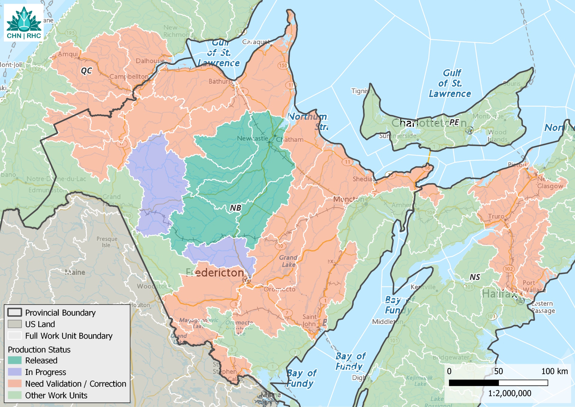
Map showing the locations of the first 5 work units of the Canadian Hydrospatial Network covering the Miramichi watershed, located north of Fredericton, New Brunswick and the production status. The map highlights two additional work units located in the same area that are in their final stages of production as well as 24 work units for which production has been initiated.
Find out more
- Access the Canadian Hydrospatial Network and the National Hydro Network data and documentation
- Read about the Hydrographic Networks
- Learn about the National Elevation Data Strategy
- Discover GeoAI
Contact us
For more information, contact geoinfo@nrcan-rncan.gc.ca.
Page details
- Date modified: