
Simply Science, February 2025
When two members of Natural Resources Canada’s (NRCan) Geodetic Survey team were invited to be part of the first all-woman crew to set up a receiving station for satellite data on the northern tip of Newfoundland, they jumped at the chance. What they discovered was a journey filled with stunning landscapes, misplaced equipment and an unexpected link to Viking-era science.
A historic mission
In the summer of 2024, Anne Farineau and Rachel van Herpt traveled to L’Anse aux Meadows, a UNESCO World Heritage site on Newfoundland’s Great Northern Peninsula, to install a new global navigation satellite system (GNSS) station. Canada’s last major network expansion was about 30 years ago, when field teams were mostly men.
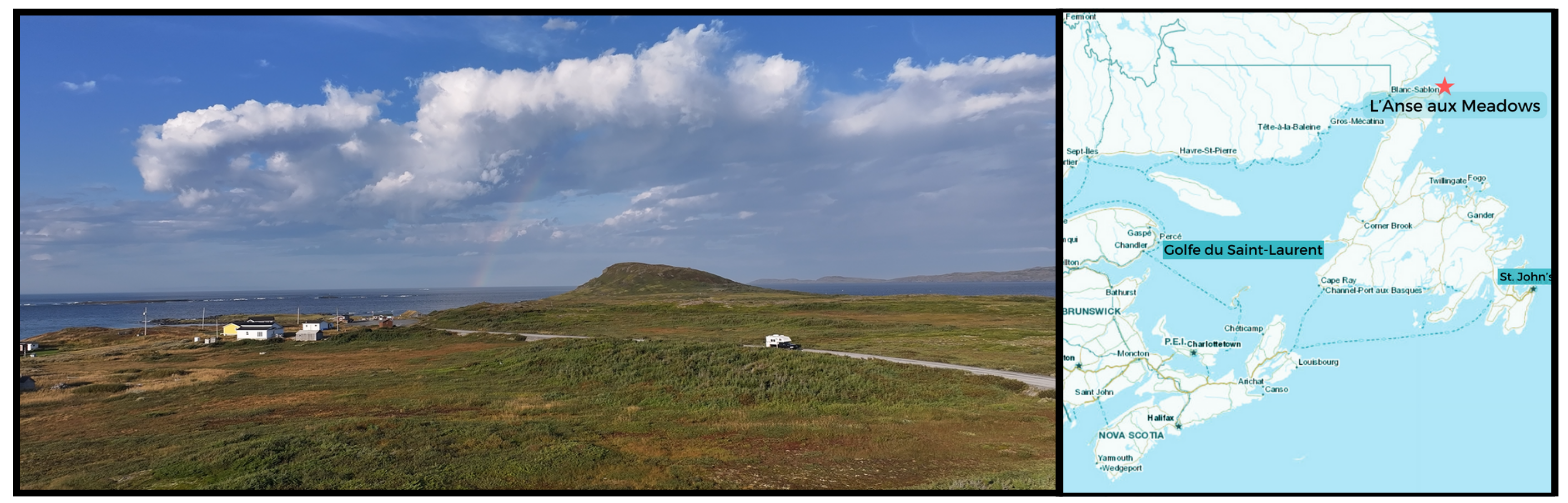
L’Anse aux Meadows is on the northeastern tip of the island of Newfoundland. (Map: Geo.ca)
The times have changed, and so has the science, but remarkably, Anne and Rachel’s mission to Newfoundland marks the first time an all-woman crew installed a GNSS station. Even the section chief and acting director on the project, Sandra Bolanos, happens to be a woman. “It’s rare to work with another woman in the field,” says Anne. “This first all-woman install felt special, especially as it honours our retired director, Dr. Calvin Klatt, who was a mentor to many and always supported women in geodesy.” Geodesy is the science of accurately measuring and understanding the Earth’s geometric shape, orientation in space and gravity field.
NRCan’s Geodetic Survey team manages about 70 permanent GNSS stations throughout the country, many of them in remote areas. Many people are familiar with the U.S.-owned GPS, or global position system, which encompasses GPS satellites. The global navigation satellite system, however, is much wider and encompasses a variety of international satellite systems, including GPS, Galileo from Europe and others. As a result, by accessing more satellite constellations from many nations, GNSS provides more accurate information than GPS alone.
Challenges and discoveries
Anne and Rachel knew exactly what they were in for: that field work is physical; that often there are few local amenities; and that there’s always a chance of wildly unpredictable weather, especially in Canada’s more remote locations. Planning this mission took a year and involved much preparation — travel logistics, drafting contracts, conducting environmental assessments and working with Parks Canada and communities to ensure the proper clearances and permissions were in place.
It took about a half day to journey from Ottawa to Newfoundland, with a stop in Nova Scotia along the way. And another six-hour drive to get to the location site, once they landed in Deer Lake. But what a drive! They were immediately struck by the rugged terrain and rich geology.
“With all the geological processes that happened there over time, the landscape is incredibly beautiful,” recalls Rachel. “The northern coast of Newfoundland shifts from towering mountains and remnants of fjords to Arctic tundra. It’s amazing to see the ocean on one side and such unique ecosystems on the other.”
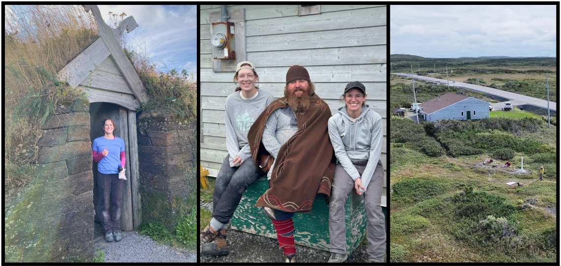
Visitors to the Parks Canada L’Anse aux Meadows National Historic site come face to face with Viking myths and storytelling. Anne and Rachel found a different side to the archaeological site. They’re seen here with Mark Pilgrim, a heritage presenter who performs under the stage name Ragnar.
When they reached L’Anse aux Meadows, they found a Parks Canada National Historic Site, where costumed interpreters guide visitors through historic scenes where Vikings built timber and sod settlements over 1,000 years ago. They quickly bonded with the heritage presenters over a deep interest in local geology. Before they knew it, they were discussing glacial isostatic adjustment (GIA), a crustal motion response to the melting of the huge glaciers and ice sheets that covered the area during the last ice age. Though the ice melted long ago, land is still adjusting (upward in L’Anse aux Meadows), controlled by dynamic processes in the crust and mantle of the earth.
GIA is just one of the earth system components the GNSS station will measure, and, as it turns out, one that’s of much interest to visitors and is included in their tours. “It was so amazing to connect their knowledge to the science we work on,” says Rachel. “Now they’ll also be able to connect it back to the GNSS station we installed on site.” It’s a full circle.
The GoodNeSS of GNSS data
GNSS data is central to our modern lives. While a GNSS station can look unassuming, advanced technology is at work as it collects ultra-precise satellite data, tracking subtle movements in the planet’s land masses with millimetre precision. Vertical movements also happen as a result of melting glaciers, earth tides, earthquakes or mantle shifts. This information helps monitor sea-level rise and manage natural disasters.
In addition to this core geoscience data, GNSS networks provide precise location and timing information critical to the economy in virtually every sector. “For instance, when laying electrical lines, it’s crucial to have their accurate position for any other work done in the area so that you make sure not to hit them,” says Rachel. With real-time GNSS data, other modern applications like autonomous vehicles and precision agriculture are made possible.
This information is especially important for planning purposes in Canada’s North, where some shorelines are constantly shifting. Adding more stations in the North and remote areas to improve positioning accuracy is a part of NRCan’s ongoing work. It will help with local harbour planning in communities where substantial change in conditions can occur, like in Churchill, Manitoba. “Uplift rates there are prominent, so planners need consistent trends over time,” says Rachel. The GNSS modernization project will also help align Canada’s property markers with international standards, important for cross-border projects like bridges and pipelines.
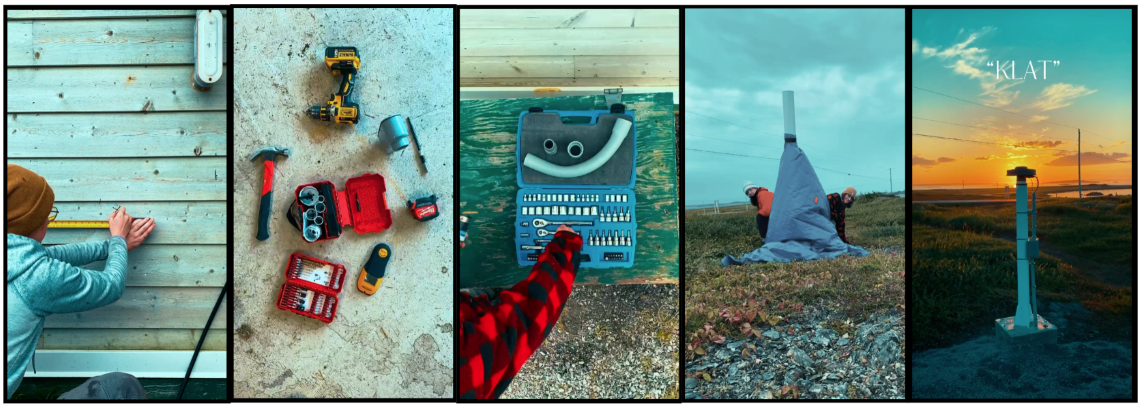
It takes a variety of hand tools and specific expertise to install a GNSS station. It’s especially important to shimmy the receiver to a precise angle and ensure it has an unobstructed view of the sky.
Unexpected hurdles
The process of installing a GNSS station can be quite challenging, and a huge number of factors could interfere. In this case, Rachel and Anne were planning a surface installation. That involves anchoring an antenna to exposed bedrock and pouring concrete around the base. The aim is to provide an unobstructed view of the sky and the satellites above. The antenna must also be precisely levelled as the data collected here will become part of Canada’s dynamic reference frame for precise latitude, longitude and more. Meeting every condition for an appropriate station site can be difficult, but with local knowledge and guidance provided by Loretta Decker and Trevor Hedderson at Parks Canada, an ideal location was found.
The biggest obstacle came when Rachel and Anne couldn’t get started as planned because of a practical problem: some of their equipment went missing in transit from Ottawa to Newfoundland. But with a few cold calls to sister departments and shipping companies across Newfoundland, a last-minute vehicle rental and thousands of kilometres later, the equipment was found and the installation was on its way.
This is the moment when fieldwork crews need to be cool, calm and collected. “You can try to plan for everything, but Murphy’s Law is a constant companion in fieldwork,” says Anne. “Something unexpected always comes up, and quick thinking is key.”
Anne and Rachel continued to install the GNSS station. After shimmying the antenna into precise position, they ran the antenna cable to the receiver inside a nearby building. In another odd twist, it turns out the best place for the receiver was in the room where heritage presenters change into their Viking costumes. That’s right — this will be the only Canadian active control station installed in a Viking dressing room.
With the GNSS station finally installed, there was just one more thing.
A moment to reflect
Anne and Rachel experienced stunning views of the Milky Way and saw an incredible northern lights display during a solar storm, which reinforced how special this station was, named in honour of Calvin Klatt. Apart from his professional work, he has a deep love of astronomy and is an avid astrophotographer who takes outstanding images of the night sky. He would have been in his element on Newfoundland’s Great Northern Peninsula with the quiet nights and very little light pollution.
Now, a few months later and back in Ottawa on a cold winter day, Anne and Rachel reflect on the experience.
“If a young girl or a woman sees someone who looks like them doing something that they didn’t think was possible — they might just change their mind and realize it is possible,” says Anne. Rachel continues. “I love the work that I do,” she says. “And knowing that women can thrive in the field while balancing roles in the office and as parents or caregivers is inspiring. It opens up what’s possible.”
Looking ahead
As NRCan GNSS station upgrades continue, Rachel and Anne are excited to inspire future generations, proving that science and exploration are open to everyone.
You can discover this story in pictures through a Simply Science photo gallery.
Explore:
Geodetic reference systems in Canada