
The science that helps keep Canada aligned in ways most people never see.
June 2026
When Catherine Robin stepped into her role as Canada’s first female chief geodesist in December 2025, she knew she was taking on more than a title. She was stepping into a new level of responsibility for geodesy, the science of measuring the Earth’s size, shape, rotation and gravity.
In practical terms, geodesy is the system that that quietly underpins daily life across the country by providing the essential reference values — latitude, longitude, height, gravity and their changes over time — that modern mapping and navigation systems depend on.

Catherine stands beside a Canadian Base Network station, part of a series of highly accurate survey markers across the country.
Geodesy is how your phone pinpoints where you are; helps ensure bridges are built exactly where they should be; and provides the high-precision timing systems that countless modern industries and applications — such as energy grids, financial institutions, navigation, construction, marine travel, mining operations and autonomous vehicles — need to maintain their accuracy up to the split second.
NRCan — Making the world run on time
The Canadian Geodetic Survey, part of Natural Resources Canada’s Surveyor General Branch, helps to keep these systems accurate and aligned.
Most people don’t think about the behind-the-scenes technology that makes it all happen, but we would certainly notice if the system stopped working.
“Think of it like a universal co-ordinate system,” says Catherine. “If we’re not all using the same one, nothing lines up.”
The invisible system behind our everyday life
While most people don’t need to know where things are with millimetre precision, tiny adjustments are of the greatest importance in many industries.
“People using GPS or map apps on their phones don’t need high precision,” says Catherine, “but industries like road construction rely on sub-centimetre accuracy — a level of precision that can save millions of dollars.”
For example, asphalt pavers equipped with advanced receivers can adjust their grade control to within a millimetre precision, a level of accuracy that — over the course of several kilometres — adds up to make a big difference.
On a larger scale, major national infrastructure projects — such as high-speed rail, new ports, dams and northern development — require accurate geodetic tools and locally accessible infrastructure at every stage of their life cycle.
It’s all because Earth is not perfectly flat, perfectly round or perfectly still: it has mountains and valleys, bulges at the equator, shifts from earthquakes and even changes because of melting glaciers. So, a highly precise measuring system is needed for maps, construction projects, global positioning systems and everything else that is based on Earth’s changing features.
And as demand for precision grows and the technology becomes more advanced, the science behind it is becoming less visible. That’s why one of Catherine’s goals is to raise public awareness of how important geodesy is to so many aspects of life in Canada.
Geodesy’s story, like Earth’s, is not static
Canada has long been a global leader in geodesy technologies, but some capabilities have been lost over time. For example, Canada’s very long baseline interferometry (VLBI) program — a national radio astronomy program that used a technique critical for tracking satellites and space-based operations — ended in 2006. But the need for up-to-date, accurate information continues, and so Canada now relies on international sources to calculate the Earth orientation parameters that are required every day for satellite and other space operations.
Addressing gaps like this is vital to Canada’s long-term capability and resilience.
“Without key geodetic capabilities, Canada becomes dependent on other nations for satellite operations,” Catherine says, underscoring that this dependence is a growing sovereignty and security concern. “We need the expertise and resources here in Canada to support national priorities.”
Advancing technologies driving change
Technology in geodesy is evolving quickly. Global positioning system (GPS) satellites that provide geolocation and time information can be vulnerable to human interference and atmospheric events. Typically orbiting at 20,000 kilometres above Earth’s surface, they move slowly and their signal is weak, making them more vulnerable to jamming and interference from events like space weather. But advanced global navigation satellite systems (GNSS) can orbit much closer to Earth, at 5,000 to 7,000 kilometres above the surface, and their stronger signals and much faster motion across the sky make them more robust against signal interference.
“A major shift is coming,” says Catherine, pointing to a new generation of low-Earth-orbit satellite positioning systems, quantum positioning and new technologies that don’t rely on GPS alone. This upcoming major shift is reflected in NRCan’s recent acquisition of Canada’s first quantum gravimeter, a gravity-measuring instrument that uses quantum mechanics to detect extremely small changes in gravitational acceleration.
The department’s geodesy team is also exploring how machine learning could improve data analysis and help monitor the national GPS network. “GPS data is constantly affected by atmospheric conditions and satellite behaviour,” says Catherine. “Artificial intelligence tools could help identify and flag issues more efficiently.”
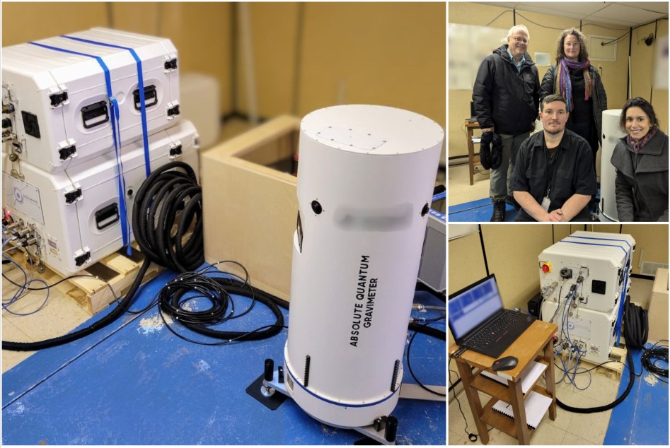
Canada’s first absolute quantum gravimeter. This new instrument represents a significant step forward in the team’s ability to measure Earth’s gravity.
A first for Canada and a path forward for women
Becoming Canada’s first female chief geodesist is a milestone that Catherine doesn’t take lightly: “Geodesy and geomatics have historically been male-dominated, especially with the fieldwork component. I hope my appointment shows women that there’s a pathway into this field.”
She speaks regularly to students and early-career professionals, encouraging them to explore the wide range of opportunities geodesy offers. Her advice is simple: “Figure out what you enjoy and what you’re good at. There’ll be a place for you in geodesy, whether you love fieldwork, data analysis, modelling or instrumentation.”
Making the invisible visible
Geodesy shapes how we move through the world, often in ways we don’t realize. For Catherine, part of her job as chief geodesist is helping people become aware of the science that lies behind and firmly supports the world around us.
Because when everything lines up — when systems are accurate, reliable and resilient — it’s not simply good science, it’s something Canadians depend on every day.
Discover more:
Remote field work: Future tech meets Viking lore (Simply Science article)
Geodetic reference systems in Canada
Global Navigation Satellite System data – Open Government Portal