
Project location: CanmetENERGY Ottawa, Ottawa, ON
Timeline: 2019-2024
Program: Funded by the Program of Energy R&D, NRCan’s Innovation Fund, and NRCan’s GeoConnections program
Project Overview
The Canadian Energy End-use Mapping (CEE Map) project’s aim was to develop an online building energy end-use and efficiency opportunities map. This included associated data, best practices, and standards to accelerate building energy retrofits and support the transition to a low-carbon economy. The project involved collaboration with municipal, utility, academic, and private sector stakeholders to create datasets and methods for energy mapping and analysis.
Core Objectives
The CEE Map project prioritized two primary use cases:
- Municipal housing retrofit program planning: Assisting municipalities in identifying opportunities for energy efficiency improvements.
- Utility conservation planning: Supporting utilities in offsetting capital costs along transmission and distribution networks.
Key areas of focus included:
- Investigating building stock data.
- Conducting housing energy simulations, modeling, and mapping.
- Leveraging open geospatial standards for improved data interoperability.
Impact and Benefits
The project delivered benefits to the City of Kelowna including:
- Identification of high greenhouse gas emitting segments within Kelowna’s housing stock. Pre-1977 single detached dwellings representing the largest segment of the low-rise residential stock are prime candidates for energy efficiency measures.
- Development of privacy-compliant measured building energy and emissions inventory data through TaNDM reports for Kelowna’s entire building stock for the 2021 calendar year.
Through collaboration with the International Energy Agency’s Energy in Buildings and Communities Program Annex 70: Building Energy Epidemiology, the project:
- Published best practices for classifying [1] and describing [2] building stock energy models.
The CEE Map also contributed to data modelling
- Contributions to the National Building Layer initiative to create a national geospatial data layer of Canadian buildings.
Key Innovations
The project developed several innovative approaches for handling modelled and measured energy data to advance standards-based building energy mapping.
Housing Energy Mapping Model
The CEE Map project:
- Developed a model of energy, emissions and costs in Kelowna’s housing stock using ArcGIS, HTAP (HOT2000), FME, and ArcGIS Online.
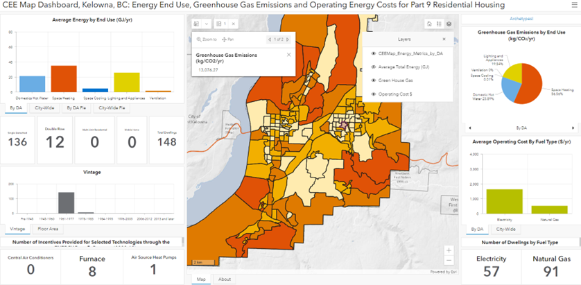
Figure 1: CEE Map Dashboard, Kelowna, B.C. - Energy End-use, GHG Emissions and Operating Energy Costs for Part 9 Residential Housing
- Conducted a validation exercise which found the archetype and map-based model consistently over-predicted energy use and generated key data insights relevant for utilities and governments to improve stock modelling accuracy (publication forthcoming)
Enabling Standardization through Concept Development Studies and Prototyping
Along with NRCan’s GeoConnections division, the CEE Map project co-sponsored and provided technical support to the Open Geospatial Consortium (OGC) to investigate standardization in the building energy domain. In collaboration with the OGC and dozens of stakeholders the project:
- Contributed to the creation of a notional Energy Spatial Data Infrastructure (ESDI) conceptual model, a key component of data strategy and governance.
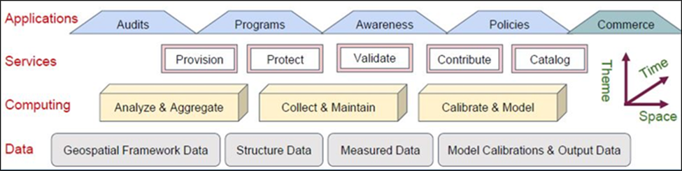
Figure 2: Proposed architecture for an Energy Spatial Data Infrastructure (ESDI)
- Enabled the development of multiple standards-based online energy mapping implementations for housing energy efficiency planning. These investigated spatial housing data integration, matching of modelled monthly heating data and augmented reality modelling and visualization of Montreal, Q.C. [3]
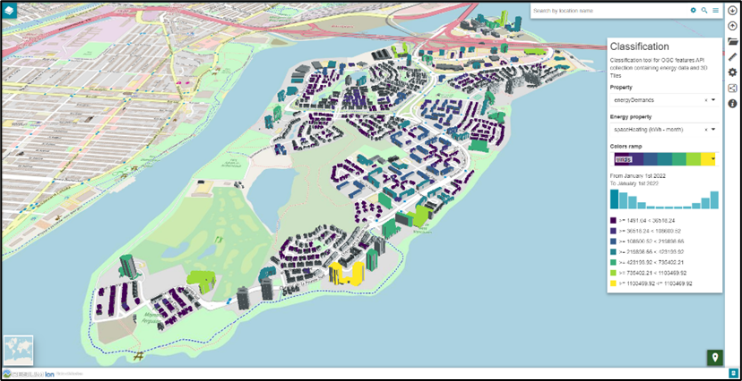
Figure 3: A prototype standards-based map of monthly heating demand on Nunns’ Island, Montreal Quebec, developed by GeoSolutions Inc for OGC Testbed-18
Open-sourcing and demonstrating the TaNDM Method
Collaboratively with stakeholders across British Columbia, the TaNDM initiative:
- Updated and open-sourced the Tract and Neighbourhood Energy Data Modelling (TaNDM) method, enabling detailed building energy and emissions inventories including reporting of measured utility data by Building Code Parts [4]
- Demonstrated TaNDM’s application in Kelowna, B.C., developing five TaNDM reports for Kelowna, B.C. for the 2021 year. [5] Results are documented in presentations [6] and a forthcoming journal article.
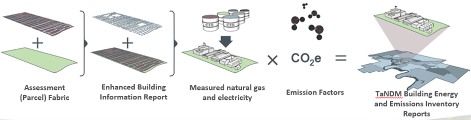
Figure 4: The conceptual approach for developing TaNDM building energy and emissions inventory reports
Results and Outcomes
The CEE Map project contributed to several publications documenting results and making recommendations for advancing building energy mapping. The project:
- Published a peer-reviewed paper in Sustainable Cities and Society highlighting the CEE Map data preparation process, including handling building permit data. [7]
- Applied building stock model reporting guidelines to characterize building energy mapping models in the 2019-2021 timeframe, providing an overview of university, private sector and non-profit applications. [8]
- Partnered with NRCan’s GeoConnections program and the Open Geospatial Consortium to conduct and publish Building Energy Mapping and Analytics Concept Development Study [9] which identified key opportunities and challenges for advancing standardization in the building energy domain.
- Successfully demonstrated through Testbed-18 that existing geospatial interoperability standards can be leveraged to create online energy maps combing buildings and modelled energy data to support a housing energy efficiency use case. The project’s Engineering Report [10] contains several data documentation recommendations to advance FAIR (Findable Accessible Interoperable Reusable) buildings and energy data towards the development of Urban Digital Twins providing decision support for numerous use cases in the built environment.
Further to these publications the CEE Map project communicated project findings and recommendations for research to the IEA Technical Collaboration Program on Cities and the Urban Energy Data Task. The CEE Map project documentation is being made available to promote best practices and standards to inform building energy mapping, urban digital twins and the transition to a low-carbon economy.
References
[1] Langevin, J., Reyna, J. L., Ebrahimigharehbaghi, S., Sandberg, N., Fennell, P., Nägeli, C., Laverge, J., Delghust, M., Mata, É., van Hove, M., Webster, J., Federico, F., Jakob, M., & Camarasa, C. (2020). Developing a common approach for classifying building stock energy models. Renewable and Sustainable Energy Reviews, 133, 110276. https://doi.org/https://doi.org/10.1016/j.rser.2020.110276
[2] Nägeli, C., Camarasa, C., Delghust, M., Fennell, P., Hamilton, I., Jakob, M., Langevin, J., Laverge, J., Reyna, J.L., Sandberg, N.H., Webster, J. (2022). Best practice reporting guideline for building stock energy models. Energy and Buildings, 111904. https://doi.org/10.1016/j.enbuild.2022.111904
[3] Open Geospatial Consortium. Testbed-18 YouTube Channel https://www.youtube.com/playlist?list=PLQsQNjNIDU84o3N3MmXTnBix_YyU7w7F6 (on that page, search: building energy)
[4] Webster, Jessica. (2025). TaNDM Github Repository. https://github.com/canmet-energy/tandm
[5] NRCan. (2024) TaNDM 2021 Energy and Emissions Inventories for Kelowna, B.C. https://github.com/canmet-energy/tandm/tree/main/Kelowna_2021_inventory
[6] Webster, Jessica. (2024). The TaNDM Building Energy and Emissions Inventory Method and Results. A Presentation to the Energy Modelling Hub 2024 Annual Forum. https://drive.google.com/file/d/1WUJsaIY7uBxyIj1B_Mr-WSLx83WibQm9/view
[7] Seyedehrabeeh Hosseinihaghighi, Karthik Panchabikesan, Sanam Dabirian, Jessica Webster, Mohamed Ouf, Ursula Eicker. Discovering, processing and consolidating housing stock and smart thermostat data in support of energy end-use mapping and housing retrofit program planning. Sustainable Cities and Society. Volume 78, March 2022, 103640. https://doi.org/10.1016/j.scs.2021.103640
[8] Claudino, P., Swanson, A., Webster, J. (2021). Scan of Building Energy Mapping Applications. Posterity Group. https://energyepidemiology.org/wp-content/uploads/2022/02/scan_building_energy_mapping-final_20211222.pdf
[9] Open Geospatial Consortium. (2021) Building Energy Mapping and Analytics Concept Development Study http://www.opengis.net/doc/PER/BEMA-CDS
[10] St Hilaire, Lee and Brookson, Aiden eds. (2023) Open Geospatial Consortium. Testbed-18 Building Energy Data Interoperability http://www.opengis.net/doc/PER/T18-D012
Contact CanmetENERGY in Ottawa
To learn more about this project, email our Office of Research Partnerships and External Relations.
Find out more