
Version 1.0
2026
Natural Resources Canada
General information product
Environment and Climate Change Canada
Natural Resources Canada
© His Majesty the King in Right of Canada, as represented by the Minister of Natural Resources, 2026
For information regarding reproduction rights, contact Natural Resources Canada at copyright-droitdauteur@nrcan-rncan.gc.ca.
Table of Contents
- Context
- Federal Flood Mapping Guidelines Series
- Federal Flood Mapping Technical Bulletins Series
- 1.0 Introduction
- 2.0 Terminology
- 3.0 Overview of Flood Hazard Map Review and Update Practices
- 4.0 Guidelines for the Review and Update Cycle of Flood Hazard Maps
- 5.0 Additional Considerations
- 6.0 Unscheduled Review Checklist
- 7.0 Review Checklist
- 8.0 References
List of Figures
List of Tables
Acknowledgements
Natural Resources Canada acknowledges the authors of this technical bulletin, the staff at Environment and Climate Change Canada (ECCC), along with Climate Risk Solutions Ltd. (CRS) for their support in completing a literature review, jurisdictional scan, and preparing a report to help inform this technical bulletin.
The documents in the Federal Flood Mapping Technical Bulletins Series are intended as a resource to support municipal, provincial, and territorial agencies and Indigenous communities working on flood hazard mapping. It is acknowledged that flood management in Canada is regulated at the provincial and territorial level of government, and that provinces and territories reserve the right to create their own guidelines specific to their jurisdictions.
Notice
Disclaimer of Liability
This technical documentation has been published by His Majesty the King in right of Canada, as represented by Natural Resources of Canada (NRCan). No warranties or representations, express or implied, statutory or otherwise shall apply or are being made by NRCan in respect of the documentation, its effectiveness, accuracy, or completeness. NRCan does not assume any liability or responsibility for any damages or losses, direct or indirect, incurred or suffered as a result of the use made of the documentation, including lost profits, loss of revenue or earnings or claims by third parties. In no event will NRCan be liable for any loss of any kind resulting from any errors, inaccuracies, or omissions in this documentation. NRCan shall have no obligation, duty, or liability whatsoever in contract, tort or otherwise, including negligence.
Additional Information
For more information about this document, please contact the Canada Centre for Mapping and Earth Observation of Natural Resources Canada: geoinfo@nrcan-rncan.gc.ca.
Context
A community achieves an elevated level of resilience when its risks are proactively managed, it is adequately prepared for known and potential disaster events, and it demonstrates an ability to recover after such events have taken place. To become resilient, a community’s mitigation planners must first understand the risks and ensure their capacity to manage those risks.
Floods are the most commonly occurring natural hazard in Canada and account for the largest portion of disaster recovery costs on an annual basis (Government of Canada, 2023; Public Safety Canada, 2019). Mitigating flood risks is therefore key to increasing the resilience of affected communities. By proactively investing in flood risk mitigation activities, a community may improve its future growth and prosperity, reducing the risk of significant disaster recovery costs, productivity losses, economic losses, destruction of non-monetary cultural assets, environmental damage, injuries, and deaths.
Flooding is the temporary inundation by water of normally dry land and can occur on marine and lake coasts, along rivers, and in low-lying areas. Flooding is caused by extreme rainfall, rapid snow/ice/glacier melt, strong winds (storm surge and waves), stream blockages from ice jams or debris, failure of engineering works, including dams, poor drainage characteristics, high groundwater levels, and other sources. Mapping that accurately depicts flood hazards, including those impacted by future conditions due to anticipated development or projected changes in climate, serves as the precondition for mitigation activities and is therefore the first step to increasing community resilience regarding flooding.
Federal Flood Mapping Guidelines Series
The Federal Flood Mapping Guidelines Series is a resource to advance and standardize flood mapping projects and activities in Canada. These guidelines address each step of the flood mapping process and provide advice to individuals and organizations in Canada that need to understand and manage flood hazards and their consequences to communities.
Federal Flood Mapping Technical Bulletins Series
The Federal Flood Mapping Technical Bulletins Series is intended to complement the documents in the Federal Flood Mapping Guidelines Series. These bulletins cover specialized subjects that may be discussed only briefly in the guideline series.
This technical bulletin, a framework for the review and update cycle of flood hazard maps, offers guidance for governments and organizations responsible for procuring, developing, maintaining, assessing, or using flood hazard maps; practitioners evaluating the validity of flood hazard studies; and other individuals and organizations involved in flood management. It outlines recommendations on the review and update cycle for flood hazard maps within Canadian jurisdictions.
1.0 Introduction
1.1 Objective
Flood hazard maps are an integral resource for decision makers who identify, characterize, and manage flood-related hazards. Flood hazard maps are cartographic representations that illustrate the probable flood extents for a given flow and/or the intensity of flooding (based on water depths and velocities or a combination of the two). These maps help to determine the potential damage to infrastructure and the threat to public safety from flooding. Flood hazard maps are generally produced using the most recent data, methods, and technology available at the time of production and show the potential inundation extents for the design criteria based on existing or reasonably foreseeable future conditions. These maps are developed by qualified professionals using geospatial, physiographic, hydraulic, and hydrologic data and applying engineering best practices and professional judgment.
Over time, gradual and/or rapid changes occur to riverine systems, floodplains, data availability, analysis methods, social and economic conditions, and policy. These changes may result in an alteration to the defined flood hazard. Thus, flood hazard mapping is a cyclical process that warrants periodic monitoring, review, and assessment (Figure 1.1). Relying on a fixed map indefinitely can lead to misinformed decisions that may put people and property at risk.
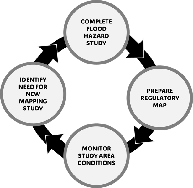
Text Version
A circular workflow diagram consisting of four light-grey circles connected by black arrows arranged in a clockwise loop. The circles contain the following text:
- “Complete Flood Hazard Study” (top)
- “Prepare Regulatory Map” (right)
- “Monitor Study Area Conditions” (bottom)
- “Identify Need for New Mapping Study” (left)
Black arrows connect each step to the next in a continuous cycle, returning from “Identify Need for New Mapping Study” to “Complete Flood Hazard Study.
Figure 1.1: The cyclical nature of flood hazard mapping.
This technical bulletin offers guidance to decision makers and practitioners on a cyclical approach to flood hazard mapping, with recommendations for reviewing and assessing existing flood hazard maps within Canadian jurisdictions. Provincial, territorial, and municipal governments, local authorities, and Indigenous communities may use this document to standardize their map review process to assess the status of their existing flood hazard maps.
Specifically, the document:
- Identifies best practices for a minimum review period.
- Describes a process and assessment indicators to determine whether an update to existing flood hazard maps is warranted during scheduled reviews.
- Lists events that may signal the need for an unscheduled review of flood hazard maps.
- Discusses the recommended review process and workflow for conducting technical reviews of flood hazard maps.
1.2 Document Structure
This technical bulletin targets decision makers who commission and apply flood hazard mapping studies and practitioners who carry out the work. The document is structured as follows:
- Section 2 introduces the terminology discussed throughout the technical bulletin.
- Section 3 includes a literature review of domestic and international best practices in flood hazard mapping, review, and update procedures.
- Section 4 provides guidance on the review and update cycle of flood hazard maps, including a standardized framework for evaluating the map validity and recommending when updates may be warranted.
- Section 5 presents additional considerations related to review for updating flood hazard maps, such as uncertainty and challenges, professional judgment, and prioritization of flood hazard map updates.
- Section 6 offers a screening checklist for determining the need for an unscheduled review of an existing flood hazard mapping study.
- Section 7 provides a review checklist for evaluating the validity of an existing flood hazard mapping study during a scheduled review.
1.3 Limitations
The following limitations should be considered when reading this document:
- This technical bulletin covers only detailed engineering-level riverine/fluvial flood hazard maps.
- This technical bulletin is not intended to replace other federal, provincial, territorial, or local legislation, regulations, bylaws, policies, technical guidance, and program standards.
- The information, recommendations, and perspectives in this technical bulletin do not necessarily reflect those of any individual provinces, territories, municipalities, or Indigenous communities.
- Flood hazard maps do not address risk, which also requires quantifying public and infrastructure vulnerability.
- Different jurisdictions may use different terms for flood hazard maps or for levels of mapping. The terminology used in this technical bulletin is defined in the following section.
2.0 Terminology
This section introduces key terms that are used throughout the remainder of this technical bulletin and are not currently defined within the Federal Flood Mapping Guidelines Series documents:
Assessment indicator: refers to the flood mapping components or factors that are assessed to inform recommendations on whether updates to existing flood hazard maps are warranted.
Assessment indicator threshold: is a set value or level for an assessment indicator (qualitative or quantitative) that, if exceeded, may signal the recommendation to update the flood hazard mapping.
Critical issue: is an error, omission, change in conditions, or regulatory change that directly affects the determination of the design flood event, flood flows, flood water levels, or mapped flood extents.
Secondary issue: is a moderate or minor error, omission, limitation, data update, or change in conditions that may influence the confidence, accuracy, completeness, or validity of a flood hazard study, but is not expected to substantially change the design flood event, flood flows, flood water levels, or mapped flood extents on its own.
3.0 Overview of Flood Hazard Map Review and Update Practices
The following subsections draw on both academic and non-academic sources to identify lessons and existing practices in flood hazard mapping review and update processes within Canada and internationally.
3.1 Canadian Provinces and Territories
In Canada, flood management is mainly the responsibility of the provinces and territories, and it can be delegated to municipalities and conservation or watershed authorities through legislation. Although a formal process to review and update flood hazard maps across most of the provinces and territories is not available, some jurisdictions have begun developing internal frameworks.
- In Saskatchewan, the Water Security Agency proposed a flood mapping revision strategy for their jurisdiction, conducting an internal audit every 5 years to assess hydrologic and meteorological data and determine whether flood hazard maps need updating (Water Security Agency, 2025).
- In Quebec, the Environmental Quality Act legislates a regular review process for hazard mapping every 10 years, based on the evolution of knowledge, available methods, and tools, natural and human-induced changes, and climate change.
- In Ontario, the Data Survey and Mapping Technical Bulletin recommends reviewing flood hazard mapping every 5 years and updating it every 5–10 years for urban areas, any area behind flood structures, or areas with critical infrastructure within the flood hazard limit. For rural areas, it recommends reviewing flood hazard mapping every 10 years and updating it every 10–15 years (Ministry of Natural Resource and Forestry, 2023).
- In British Columbia, Engineers and Geoscientists of British Columbia’s Professional Practice Guidelines: Flood Mapping in British Columbia recommends that flood maps be reviewed every 10 years when change is considered likely, such as after an extreme flood or when the physical conditions of the watersheds or floodplains change (Engineers and Geoscientists BC, 2017).
The current document aims to support jurisdictions without clear guidelines for updating flood hazard maps by providing a framework for the review and update cycle of flood hazard maps.
3.2 Selected International Jurisdictions
The United States, the European Union, and Australia are jurisdictions that were frequently identified in literature as regions where flood hazard mapping processes have been refined and formalized. The following sections outline the processes in these jurisdictions for the review and update cycle for flood hazard maps.
3.2.1 United States
In the United States, flood hazard maps are created and disseminated primarily by the Federal Emergency Management Agency (FEMA), whose mandate extends from the position of the federal government as the primary insurer of flood risks via the National Flood Insurance Program. The main impetus for maintaining current and valid flood hazard maps is to ensure actuarially sound flood insurance premium rates. FEMA’s Flood Map Service Center is responsible for producing Flood Insurance Rate Maps, official community maps that show Special Flood Hazard Areas and risk premium zones (FEMA, 2023). Each community that participates in the National Flood Insurance Program has a designated floodplain administrator who works with FEMA to engage local engineers and surveyors to collect map data. FEMA engages local experts to understand drainage conditions and other local context, then combines the data in a model to create and publish a draft of an updated flood hazard map, after which the community may submit supplementary technical data to support or appeal the map.
FEMA is mandated to review community flood hazard maps every five years and decide whether to update or replace the maps (FEMA, 2021a). The Coordinated Needs Management Strategy is a geospatial database maintained by FEMA to track the lifecycle of flood hazard studies and maps by analyzing their currency and validity and determining whether local conditions are still adequately represented in the Flood Insurance Rate Map for that area (FEMA, 2021b). In this process, the engineering study underpinning the map undergoes a validation process to evaluate the accuracy and depiction of the flood hazard and any changes in topography, hydrology, and land development are evaluated through a series of “triage checks.” Specifically, the flood hazard study and map are evaluated against 16 possible “change indicators,” seven of which are deemed “critical” and nine of which are deemed “secondary” (FEMA, 2021a). If the flood hazard study fails against any one of the critical indicators or any four of the secondary indicators, it is flagged for validation and prioritized for updating.
3.2.2 Europe
Flood risk management across the European Union (EU) has been heavily influenced by the EU Floods Directive, adopted in 2007, which sought to achieve a coordinated effort to address the negative impacts of floods (European Union, 2007). The Floods Directive mandated all member states to (1) identify areas likely to experience significant flooding, (2) map flood extents and people and assets at risk in these areas, and (3) implement coordinated actions to address flood risks (European Commission, 2024). By the end of the first implementation cycle (2010–2015), most member states had adopted national programs for flood hazard mapping, risk assessment, and risk management (Hedelin, 2016).
Under the EU Floods Directive, member states were required to create, in addition to flood hazard maps, flood risk maps that showed the potential adverse consequences of these flood scenarios, including the number of inhabitants impacted, the type of economic activity impacted, and any pollution control facilities potentially affected (Müller, 2013). The Directive also included specific guidance on the currency of flood hazard maps stating, in Article 14 of Chapter VIII, that “the flood hazard maps and the flood risk maps shall be reviewed, and if necessary updated, by 22 December 2019 and every six years thereafter” (European Union, 2007). Beginning in 2023, flood hazard maps updated by member states on this 6-year schedule are now aggregated into the European Commission’s Flood Risk Areas Viewer, a geospatial database that depicts areas of potentially significant flood risk (European Commission, 2023).
EU member states each follow their own map update processes to meet the Directive. In Germany, for example, this process is led by state-level ministries and environment agencies. A federal water working group has established minimum guidelines to ensure some consistency in the 6-year updates. They replicate the EU’s requirement to update maps based on hazard and risk parameters as described above (Surminski et al., 2020).
3.2.3 Australia
Primary responsibility for flood hazard mapping in Australia has traditionally rested with local governments and regional watershed authorities. As a result, flood hazard maps are generally limited to formally designated hazard areas and areas with frequent flooding. Over the past ten years, however, state governments have intervened to address gaps in coverage and quality of maps in response to several significant flood events. Queensland, for instance, launched a mapping program covering the entire catchment and low population areas with the objective of reducing the time it took to develop maps (Dufty et al., 2020). New South Wales advises local governments to update flood hazard maps based on the best available data when they undergo land use planning or local strategic planning statements (Environment and Heritage Group, 2023). Victoria developed a strategy in 2016 that offers specific advice on various triggers for updating flood hazard maps (Department of Environment Land, Water and Planning, 2016). These triggers include availability of hydrometric, hydrodynamic, and topographical data; land use changes; new analytical approaches; new flood measurement; erosion; and development of flood control and hydraulic structures.
At the national level, guidance has emerged on the methodology for flood hazard mapping but without much detail on updating maps. The National Flood Risk Advisory Group has developed a “Resilience Handbook” hosted by the Australian Institute for Disaster Resilience. Under a section prioritizing improvements in understanding flood risk, the handbook suggests that local governments should collect data after floods or via floodplain studies and give information as available and transparent as possible. A knowledge hub set up to collect any new map updates is recommended as a means of aggregating local flood hazard mapping (Australian Institute for Disaster Resilience, 2017). The national government, in addition to New South Wales and Victoria, has set up a flood hazard mapping portal that planners, insurers, and engineers can now use to identify whether new data, maps, or floodplain studies are available (Dufty et al., 2020).
4.0 Guidelines for the Review and Update Cycle of Flood Hazard Maps
The proposed cycle to review and update maps incorporates lessons, approaches, and best practices already implemented in other nations and in some jurisdictions in Canada. Specifically, the proposed approach incorporates regular review periods aligned with those currently used in the United States (that is, 5 years) and the European Union (that is, 6 years). Further, the proposed procedure leverages FEMA’s “triage checks” approach against selected “change indicators” (FEMA, 2021a). The proposed framework uses a modified approach to consider the severity of the change and the indicators are explicitly designed to account for the unique considerations and challenges affecting the validity of flood hazard mapping studies in Canada.
4.1 Framework for the Review and Update Cycle of Flood Hazard Maps
This section describes the proposed framework to review and update flood hazard maps based on their representation of existing conditions; the steps in the framework are collectively referred to as the review and update cycle for flood hazard maps. In general, maps should be updated when there is evidence of substantial changes to the watershed hydrology, flooding mechanisms, river morphology, river hydraulics, or sediment supply that could potentially impact the mapped flood hazard.
The framework is a formal, rigorous, and systematic process to assess the validity of a flood hazard map against a defined set of indicators. Figure 4.1 presents a decision tree illustrating the proposed workflow for verifying the validity of the mapped flood hazard.
The first step in the workflow is to check whether the existing map was created or reviewed more than 10 years ago. If it was, the map undergoes a scheduled review. If it was created or reviewed within the last 10 years, the reviewer checks for the occurrence of any events that would trigger the need for an unscheduled review (see Section 4.1.2). If an unscheduled review is not triggered, the map is considered a verified map.
During the scheduled or unscheduled review, assessment indicators are evaluated for errors, omissions, or lack of data that could signal a critical or secondary issue with the flood hazard map (see Section 4.2); where a critical issue or multiple secondary issues are identified, the existing map may no longer be sufficiently accurate or representative of current conditions and an updated flood hazard study is recommended. Upon completion of the new flood hazard study, the resulting map becomes the verified map. If the review concludes with no critical issues and none or few secondary issues that, according to the reviewer’s professional judgment, do not affect validity, the existing map is confirmed as a verified map without recommending a new flood hazard study.
Once the map is reviewed and marked as a verified map, a new review cycle begins, with the next scheduled review in 10 years.
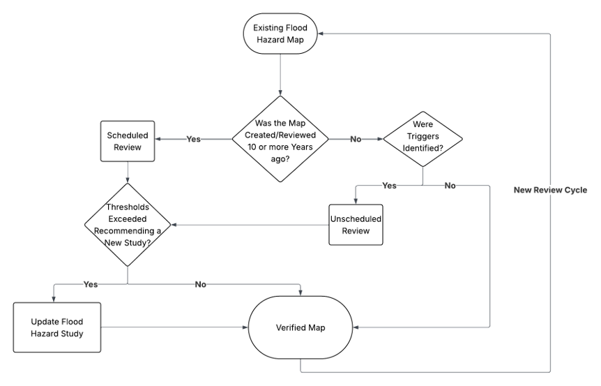
Text Version
A workflow decision tree begins with an oval labelled “Existing Flood Hazard Map.” An arrow leads downward to a diamond labelled “Was the Map Created/Reviewed 10 or more Years ago?”
- If Yes, the workflow proceeds to a rectangle labelled “Scheduled Review.”
- If No, the workflow proceeds to a second diamond labelled “Were Triggers Identified?”
From “Scheduled Review,” the workflow continues to a diamond labelled “Thresholds Exceeded Recommending a New Study?”
- If Yes, the workflow proceeds to a rectangle labelled “Update Flood Hazard Study.”
- If No, the workflow proceeds to an oval labelled “Verified Map.”
From “Were Triggers Identified?”
- If Yes, the workflow proceeds to a rectangle labelled “Unscheduled Review,” then to “Thresholds Exceeded Recommending a New Study?”
- If No, the workflow proceeds directly to “Verified Map.”
- If Yes, the workflow proceeds to a rectangle labelled “Update Flood Hazard Study.”
From “Update Flood Hazard Study,” the workflow proceeds to “Verified Map.”
A line from “Verified Map” loops back to “Existing Flood Hazard Map” and is labelled “Monitoring Cycle.” The diagram includes arrows and yes/no labels to indicate the decision paths between steps.
Figure 4.1: Workflow decision tree for the review and update cycle of flood hazard maps.
4.1.1 Scheduled Review
This framework for the review and update cycle of flood maps recommends a 10-year review interval, consistent with best practices identified through the literature review and jurisdictional scan showing that flood hazard maps should be reviewed at a regular interval.
A 10-year cycle is consistent with review cycles of flood or erosion hazard assessment in various Canadian jurisdictions. This interval provides sufficient time that advances in tools, technologies, modelling approaches, and data availability may warrant a map update. It also allows sufficient time that a map update may be warranted due to natural and human-induced changes (for example, hydrologic factors, land use, shifts in regional flood regimes due to climate change) that can impact flood hazards. Thus, a 10-year review interval ensures the accuracy and reliability of a community's flood hazard study and associated maps.
Note that the 10-year review period does not mean that all maps will be updated every 10 years; rather, it means that all maps will be evaluated at least every 10 years to determine whether an update to the map is recommended. The identification of a need for a map update through the scheduled review indicates that climatic, hydrologic, hydraulic, and/or geomorphologic indicators exceeded thresholds and there is a high potential that these changes will affect flood hazards in the study area.
4.1.2 Unscheduled Review
While the 10-year review cycle is a baseline for reviewing flood hazard maps, there are also circumstances that lead to an unscheduled review: substantial climatic, hydrologic, hydraulic, or geomorphologic changes or events that may result in alterations to the flood hazard extents for a given study area. These changes may impact the validity of the existing flood hazard maps and an unscheduled review is recommended under these circumstances. Professional engineering judgment should be applied when assessing the conditions of the study area and the need for an unscheduled review.
Events that would trigger an unscheduled review:
- A flood greater than the mapped flood event.
- A flood event resulting in the loss of life and/or substantial property damages.
- Substantial geomorphological change in the floodplain/channel or land use change in the watershed/floodplain potentially affecting the mapped flood hazards.
- An existing flood hazard study not reviewed, stamped, and dated by a qualified professional.
- New regulations or guidelines leading to a modified and more conservative flooding criterion as specified by the jurisdictional authority.
4.2 Review Process of Existing Flood Hazard Maps
The review of existing flood hazard maps must be completed by a qualified professional. For an existing flood hazard study, the assessment evaluates 23 indicators across six categories: 1) regulatory criteria, 2) data requirements, 3) hydrologic analysis, 4) changing conditions, 5) hydraulic analysis, and 6) reporting.
The goal of the assessment is to identify quality issues with the existing flood hazard map and changes in conditions that could compromise the validity and accuracy of the existing flood hazard study. The assessment identifies critical and secondary issues associated with each indicator to determine whether an update is recommended for the existing flood hazard maps. Critical and secondary issues are defined in Table 4.1. If any of the critical issues or multiple secondary issues are identified as part of the assessment, it is recommended, as discussed in Table 4.1, that the existing flood hazard map be updated. The assessment indicators are presented in Section 4.2.1.
Table 4.1: Rationale for indicator thresholds used to recommend flood hazard maps updates.
| Threshold | Rationale |
|---|---|
| 1 or more critical issues | A critical issue is an error, omission, change in conditions, or regulatory change that directly affects the determination of the design flood event, flood flows, flood water levels, or mapped flood extents. Identification of 1 or more critical issues means that there is a high likelihood that the existing flood hazard study is no longer valid. |
| Multiple* secondary issues | A secondary issue is a moderate or minor error, limitation, omission, data update, or change in conditions that may influence the confidence, accuracy, completeness, or currency of a flood hazard study, but is not expected to substantially change the design flood event, flood flows, flood water levels, or mapped flood extents on its own. The compounded uncertainty from multiple secondary issues increases the potential to affect the existing flood hazard map results, as the cumulative effect could yield either overall uncertainty across the entire study or high levels of uncertainty localized in some components of the study. |
* The threshold number of secondary issues is study-specific and should be confirmed by the qualified professionals reviewing the map.
4.2.1 Assessment Indicators
Table 4.2 presents the assessment indicators for the review of flood hazard mapping studies for riverine environments. Sections 4.2.2 to 4.2.7 describe each assessment indicator and provide examples, where applicable, of errors, omissions, and lack of data that could signal a critical or secondary issue with the flood hazard map. For some assessment indicators, the critical issue category is not applicable due to limited potential to substantially affect flood hazard extents. Where such effects are substantial, they would typically be captured under other assessment indicators.
Some indicators may not be applicable to a particular flood hazard mapping study and may be excluded from the assessment. In these cases, the qualified professional should apply their judgment, provide a rationale for diverging from the given recommendations for critical and secondary issues, and document the decision.
Table 4.2: List of assessment indicators.
| Category | ID | Assessment Indicator |
|---|---|---|
| A: Design or regulatory criterion | A-1 | Design or regulatory flood |
| B: Data requirements | B-1 | Watershed characterization data |
| B: Data requirements | B-2 | Topographic and bathymetric data |
| B: Data requirements | B-3 | Infrastructure data |
| B: Data requirements | B-4 | Hydrometric data |
| B: Data requirements | B-5 | Meteorological data |
| B: Data requirements | B-6 | High water marks |
| C: Hydrologic analysis | C-1 | Hydrometric characterization |
| C: Hydrologic analysis | C-2 | Model conceptualization, setup, and input data |
| C: Hydrologic analysis | C-3 | Calibration, validation, and sensitivity |
| C: Hydrologic analysis | C-4 | Frequency analysis |
| C: Hydrologic analysis | C-5 | Flooding mechanisms |
| C: Hydrologic analysis | C-6 | Hydrologic analysis assumptions and limitations |
| D: Changing conditions | D-1 | Climate change |
| D: Changing conditions | D-2 | Land use changes |
| D: Changing conditions | D-3 | Human-induced changes to the watercourse |
| D: Changing conditions | D-4 | Fluvial geomorphic changes to the watercourse |
| E: Hydraulic analysis | E-1 | Methodology and input data |
| E: Hydraulic analysis | E-2 | Calibration, validation, and sensitivity |
| E: Hydraulic analysis | E-3 | Hydraulic results |
| E: Hydraulic analysis | E-4 | Hydraulic analysis assumptions and limitations |
| F: Reporting | F-1 | Technical reporting and professional standards |
| F: Reporting | F-2 | Flood hazard maps |
4.2.2 Category A: Design or Regulatory Criterion
Design or regulatory flood (A-1): Flood event selected as the basis, by the responsible authority, for flood hazard mapping, and flood risk management. Provincial and territorial jurisdictions or responsible delegated authorities may update the design or regulatory flood, for example, when new information indicates that the previously adopted flood standard may no longer represent an acceptable flood risk.
- Critical issue: The design or regulatory flood is changed by the responsible authorities.
- Secondary issue: Not applicable as the design or regulatory flood is critical to the mapped flood hazard and any change would represent a critical issue.
4.2.3 Category B: Data Requirement
Watershed characterization data (B-1): Flood hazard mapping studies involve hydrotechnical procedures relying on watershed characterization. The data used include watershed boundaries, slope, geospatial data of lakes, reservoirs, watercourses, surficial geology, land use, infrastructure affecting watershed delineation, hydrologic conductivity, and other relevant hydrologic features with the potential to affect water availability and movement throughout the watershed.
- Critical issue: Not applicable.
- Secondary issue: Error identified in the estimation of parameters such as watershed area(s), runoff coefficients, time of concentration, etc.
Topographic and bathymetric data (B-2): These data form the basis of both hydrologic and hydraulic analyses and support the accurate delineation of flood extents. Topographic data are used to characterize watershed features that influence runoff generation, flow routing, and storage during hydrologic analyses. Hydraulic models require detailed representations of floodplain topography and channel bathymetry to simulate water levels, flow velocities, flood depths, and flood extent. During the map generation process, flood hazard extents are refined combining topographic information with modelled flow and water level for the design or regulatory flood.
- Critical issue: Not applicable.
- Secondary issue: Insufficient or poor-quality bathymetric data (for example, insufficient spatial resolution and coverage, inconsistencies between topographic and bathymetric data, etc.); simplified bathymetric assumptions lacking justification or supporting scientific evidence; topographic data with higher accuracy or resolution are available for the study area.
Infrastructure data (B-3): Infrastructure (such as culverts, bridges, in-water structures, revetments, etc.) is periodically replaced, removed, or altered. The potential effect of such changes on flow and level regulation is dependent on the type of structure, the location of the structure, the type of changes to each structure, and the number of structures that are altered. This indicator excludes infrastructure data associated with flood mitigation measures (evaluated under indicator D-3).
- Critical issue: One or more major hydraulic structures (for example, bridge, culverts, control structures, berms) within the study area have been added, removed, or substantially altered with respect to hydraulic capacity, resulting in a direct effect on flood flows, water levels, or mapped flood extents.
- Secondary issue: One or more minor hydraulic structures (for example, local culvert replacement, drainage works) affecting hydraulic capacity within the study area, have been added, removed, or changed.
Hydrometric data (B-4): Hydrometric data (for example, instantaneous and/or mean daily flows and/or water levels) form the basis for flood frequency analysis and are also integral to the verification of hydrologic and hydraulic models. The validity of mapped flood hazards depends on the quality, length, representativeness, and interpretation of available hydrometric records.
- Critical issue: Incorrect station selection or period of record; substantial errors in data processing and analysis; availability of new hydrometric information that results in a material revision to the estimated magnitude or frequency of the design or regulatory flood.
- Secondary issue: Availability of extended records; minor data correction; minor errors in data processing.
Meteorological data (B-5): Reliable, representative, and long-term meteorological data are necessary for hydrologic analyses used to estimate the design or regulatory flood and evaluate the potential effects of climate variability. Meteorological data relevant to flood hazard studies include precipitation, rainfall, snowfall, barometric pressure, temperature, evaporation, number of days above/below zero, and wind speed and direction. These data influence the volume, timing, and mechanisms of runoff generation that contribute to flooding.
- Critical issue: Incorrect characterization of extreme precipitation (for example, erroneous IDF relationship); inaccurate representation of rain-on-snow events.
- Secondary issue: Updated meteorological records that may refine IDF relationships, estimates of depth of snowpack, snow accumulation or melt, or the likelihood of alternative flood-generating mechanism; observed conditions that suggest a divergence from previous assumptions of future climate.
High water marks (B-6): High water marks are physical evidence of a flood event and include debris, sediment deposits, staining, tree scars, and water damage. Survey crews collect these physical indicators to document approximate flood extents and elevations. High water marks are used in model calibration and validation, ground truthing, determining mapping extents, post-flood assessment, and for regulatory and legal purposes.
- Critical issue: Not applicable.
- Secondary issue: Errors in datum or interpretation of high water marks; new high water mark data available for the study area.
4.2.4 Category C: Hydrologic Analysis
Hydrometric characterization (C-1): When available, streamflow records at a hydrometric station in the study area provide the most accurate and reliable data to estimate design flows. However, there may be gaps or quality issues in the record or it may require transformation and analysis to characterize streamflows for the study area. Different hydrologic approaches are applied to reconstruct the missing data, such as extending records from reference and neighbouring hydrologically similar watersheds and regional basins.
- Critical issue: Use of non-representative hydrometric records given the characteristics of the watershed, location of the station, duration of records, or quality of data that lead to an inadequate representation of streamflow regime and associated flood flows in the study area.
- Secondary issue: Use of hydrometric records from stations with limited similarity to the study watershed or application of hydrologic approaches to reconstruct missing records that may introduce uncertainty in the characterization of streamflow regimes and flood frequency statistics in the study area while methods which would result in less uncertainty are available.
Model conceptualization, setup, and input data (C-2): Modelling techniques may be used in hydrologic analysis to estimate streamflow where hydrometric stations are limited or design flows are based on a historical storm or a synthetic design storm. Because design flood flows can be based on hydrologic model outputs, the validity of the flood hazard extents depends on the appropriateness of the model conceptualization, parameterization, and input datasets. Errors or limitations in these components may affect estimates of design flood flows and resulting flood hazard extents.
- Critical issue: Not applicable.
- Secondary issue: Use of a model or approach that is not well suited to the dominant hydrologic processes of the watershed; use of an inappropriate model domain or watershed discretization that does not adequately represent important tributaries, storage areas, or drainage pathways; use of spatial or temporal discretization that is too coarse to represent watershed response or storm characteristics at the scale relevant to flood estimation.
Calibration, validation, and sensitivity (C-3): Hydrologic model uncertainty is understood and evaluated through calibration, validation, and sensitivity analysis.
- Critical issue: Not applicable.
- Secondary issue: Missing calibration, validation, or sensitivity analyses; new flood flow data that could be used to improve model calibration and validation to reduce model uncertainty.
Frequency analysis (C-4): Flood frequency analyses use the statistical properties of observed, historical, or derived streamflow or water level records to define a relationship between flow magnitude (or water level) and annual exceedance probability (AEP) at a given site. The relationship is used to estimate the flow (or water level) for one or more desired flood frequencies.
- Critical issue: Use of inadequate probability distribution; failure to account for the entire period or record; substantial errors in data screening.
- Secondary issue: Use of alternative but technically defensible probability distribution; limited sensitivity testing supporting the selection of the statistical distribution; availability of new data that could alter flood frequency estimates.
Flooding mechanisms (C-5): Canadian riverine systems experience different types of flood mechanisms, and flood hazard studies must identify which flood mechanism dominates the design flood for the study area.
- Critical issue: New data suggesting a new dominant flooding mechanism that was not considered in the flood hazard study (for example, evidence demonstrating that ice-jam flooding controls flood flows rather than open-water flooding).
- Secondary issue: Secondary flooding mechanism was not evaluated or estimated in the analysis but new data suggest is plausible (for example, ice-jam flooding was not assessed despite a history of occasional ice-related flooding, but available evidence indicates open-water flooding remains the dominant mechanism); new data suggesting emerging flood processes associated with changing climatic conditions that were not assessed in the study but have not yet been shown to affect the design flood event.
Hydrologic analysis assumptions and limitations (C-6): Hydrologic analyses rely on assumptions, simplifications, and methodological choices to represent complex watershed processes and estimate the magnitude, frequency, and timing of flood flows. The validity of flood hazard extents depends on whether the assumptions and limitations underlying the hydrologic analysis remain appropriate considering current scientific knowledge, new available data, improved analytical methods and standards, and evolving watershed or climatic conditions. Therefore, the review of assumptions and limitations provides an important indication of the confidence that can be placed in the design or regulatory flood flows estimates used to delineate flood hazard extents.
- Critical issue: Not applicable.
- Secondary issue: Reliance on assumptions that were reasonable at the time of the study but could now be refined using updated scientific knowledge or guidance; assumptions that are not fully documented or justified (for example, assumption that open-water flooding is the dominant flood mechanism although winter flows and ice data are not available); missing discussion of uncertainty associated with flood frequency analysis, model parameters, or input datasets.
4.2.5 Category D: Changing Conditions
Climate change (D-1): Human activities are changing meteorological conditions at global and regional scales, and these changes are expected to continue. As a result, climate change is and will become increasingly reflected at local scales in flood-relevant climate conditions. For example, changes in spatial and seasonal patterns of temperature, precipitation, and other climate variables may increase or decrease the magnitude and frequency of floods and expose historically low-flood-risk areas to flooding (Warren & Lemmen, 2014). In addition, climate change effects can result in changes to plausible flood mechanisms.
- Critical issue: Not applicable.
- Secondary issue: Climate change was not considered or the analysis is based on superseded climatic scenarios, projections or methods; new available meteorological records or updated projections indicate that the climate scenarios or assumptions may no longer be representative or consistent with current scientific understanding.
Land use changes (D-2): Land use can affect the watershed hydrology contributing to flood hazard extents by affecting runoff response, infiltration and evaporation. Changes to land uses in the floodplain may directly affect flood water levels. Examples of land use changes that may affect the stationarity of streamflow and magnitude of flood events include urbanization, agricultural drainage, forestry activities, water control and regulations, and landscape disturbances such as forest fires.
- Critical issue: Not applicable.
- Secondary issue: Expansion of urban development resulting in increased impervious surfaces; changes in agricultural practices; forest fires altering vegetation cover and soil properties including infiltration potential.
Human-induced changes to the watercourse (D-3): Watercourse alterations, including flood mitigation measures and engineering works, can change hydrologic and hydraulic processes in the study area that influence flood hazard extents. These changes may affect flood behaviour by changing flow conveyance, flow routing, floodplain connectivity, water levels, and inundation patterns within the study area.
- Critical issue: Substantial changes to the watercourse such as channel realignment, reconfiguration, relocation, diversion; channel dredging; construction, removal or major modification of hydraulic structure; construction of permanent flood mitigation structures.
- Secondary issue: Changes that might have only localized impacts on flood mitigation such as localized bank stabilization; small-scale flood protection works affecting a limited area; minor channel modifications or localized dredging; minor modifications to existing hydraulic structures with negligible effects on conveyance.
Fluvial geomorphic changes to the watercourse (D-4): Fluvial geomorphic processes can alter channel geometry, floodplain connectivity, and hydraulic conditions over time. Continuous erosion incrementally varies the hydrodynamic factors that impact flood hazard extents, while catastrophic erosion may dramatically impact the flood hazard extents. Aggradation, channel migration and avulsion, can also change the channel geometry.
- Critical issue: Substantial morphological changes to channel geometry such as major channel migration; channel avulsion creating a new primary flow path; loss or creation of flood storage areas.
- Secondary issue: Localized erosion or deposition on banks or bed; minor channel widening, narrowing or bed adjustments; gradual meander migration that has not materially altered floodplain flow patterns, connectivity or flood storage.
4.2.6 Category E: Hydraulic Analysis
Methodology and input data (E-1): Hydraulic analysis is used to estimate how flows influence water levels, flow velocities, and flow distribution within a watercourse and its adjacent floodplain. Because mapped flood hazard extents are derived from hydraulic analysis results, their validity depends on the appropriateness of the analytical methodology, assumptions, dimensionality, computational domain, representation of hydraulic controls, parameter values, boundary conditions, and input data. Errors or limitations in these components may affect estimates of flood water levels, flow patterns, and resulting flood hazard extents.
- Critical issue: Not applicable.
- Secondary issue: Use of a model or approach that does not capture the dominant hydraulic processes of the reach (for example, use of a 1-D approach where 2-D processes are dominant); use of a domain that does not characterize watercourse geometry, floodplain areas or hydraulic controls (for example, non-representative cross-sectional and longitudinal profiles or failure to incorporate available topographic, bathymetric, or survey information); spatial discretization that is too coarse to adequately capture these elements.
Calibration, validation, and sensitivity (E-2): Hydraulic uncertainty is understood and evaluated through calibration, validation, and sensitivity analysis.
- Critical issue: Not applicable.
- Secondary issue: Missing calibration, validation, or sensitivity analyses; new data (for example, high water marks) that could be used to improve calibration and validation of river hydraulics to reduce model uncertainty.
Hydraulic results (E-3): Hydraulic calculations are applied to the design or regulatory flood flow to predict flood water levels under a subset of selected assessment scenarios. Hydraulic modelling results need to be interpreted to estimate the flood hazard extents.
- Critical issue: Misinterpretation of hydraulic results leading to the mapping of an incorrect flood scenario; failure to incorporate hydraulic controls identified in the hydraulic analysis, such as bridges, culverts, control structures, berms, or major flow obstructions.
- Secondary issue: Inadequate interpretation of water surface elevation between cross-sections or reaches; errors in the conversion of hydraulic results into flood hazard extents; insufficient consideration of physical controls on flood hazard extents (such as roads, bridges, berms, floor protection works or other barriers to flow); inconsistent treatment of disconnected inundation areas or local depressions.
Hydraulic analysis assumptions and limitations (E-4): Hydraulic analyses rely on assumptions, simplifications, and methodological choices to characterize the hydraulic response of the watercourse to flood events. These assumptions may relate to boundary conditions, hydraulic parameters, representation of hydraulic structures, topographic and bathymetric data, or channel and floodplain characteristics. The validity of mapped flood hazard extents depends on whether the assumptions and limitations underlying the hydraulic analysis remain appropriate considering current scientific knowledge, new available data, improved analytical methods, and changes in the channel or floodplain. A review of assumptions and limitations provides an important indication of the confidence that can be placed in estimated flood levels and resulting flood hazard extents.
- Critical issue: Not applicable.
- Secondary issue: Reliance on assumptions that were reasonable at the time of the study but could now be refined using updated scientific knowledge or guidance; assumptions that are not fully documented or justified by available data (for example, roughness coefficient for the channel and floodplain, boundary conditions, hydraulic parameters); missing discussion of uncertainty associated with the hydraulic analysis and input datasets.
4.2.7 Category F: Reporting
Technical reporting and professional standards (F-1): Flood hazard mapping studies should be supported by sufficient technical documentation to allow independent review, interpretation, and future updates. Technical reports should clearly document the regulatory flood criterion, data sources, methodologies, hydrologic and hydraulic analyses, consideration of changing conditions, results, and clearly state assumptions, limitations, and uncertainties. The information should be presented in a stand-alone technical report prepared consistent with applicable professional practice and reviewed, stamped, and dated by a qualified professional, as required by the responsible jurisdiction.
- Critical issue: Absence of a technical report; documentation is insufficient to understand, reproduce, verify or appropriately apply the flood hazard extents (for example, methodologies, assumptions, data sources, or analyses are undocumented); technical report is not reviewed, stamped, and dated by a qualified professional.
- Secondary issue: Incomplete description of data sources or analytical methods; flood hazard extents are difficult to interpret due to poor organization or presentation of information; inconsistent terminology, figures, tables or references; technical information is not presented in a clear and accessible manner.
Flood hazard maps (F-2): Flood hazard maps communicate the spatial extent and characteristics of flood hazards and are used to support land-use planning, emergency management, and flood risk assessment. To support these applications, maps should accurately represent study results and include sufficient information to allow users to understand the mapped hazard, the study limitations, and the conditions under which the study results apply.
- Critical issue: Misrepresentation of flood hazard extents due to misrepresented water surface elevation data, topographic data, or critical infrastructure data affecting the mapped flood hazard extents; incorrect georeferencing, coordinate system, or alignment between mapping layers; omission of essential map elements (for example, mapped flood scenario, legend, scale).
- Secondary issue: Ambiguous, incomplete or unclear symbology or labelling; inconsistency in cartographic elements across map sheets; formatting, annotation, and accessibility issues; uncertainty is not communicated; information required by the delegated authority is missing.
4.3 Assessment Reporting
Monitoring, evaluation, and reporting practices should be adopted to document the review cycle in the assessment procedure. Flood hazard maps could be tracked through provincial/territorial or local databases, where metadata would document review cycles and flag maps recommended for update.
As part of the assessment procedure, it is recommended that the findings be documented in an “assessment report” reviewed, stamped, and dated by a qualified professional, identifying the outcome of the assessment. The report should include and describe the critical and secondary issues of each indicator. The report should provide the data and rationale demonstrating how each indicator was assessed, the result of the assessment, and the date of completion of the assessment to evaluate the validity of the maps and support future assessments under the standardized framework.
4.4 Outcome of the Review
After reviewing the existing flood hazard map against the 23 indicators in Table 4.2. The qualified professional determines whether the existing map is still valid or recommends an update. A total of 11 critical issues can be flagged recommending updating the existing flood maps, while almost every indicator (except regulatory criteria) can be flagged as a secondary issue to signal the presence of errors, omissions, data updates, or changes in conditions that may influence the confidence, accuracy, or completeness of the map.
While the thresholds in Table 4.2 (any of the critical issues and multiple secondary issues) provide a minimum standard, professional judgment should be applied to identify the issues for each indicator. Professional judgment should also be applied to the threshold for the number of secondary issues depending on the severity of the issues in the indicator and potential impacts on the mapped flood extents for the specific study. Overall, the framework for the review and update cycle of flood hazard maps is a structured assessment process that ensures both primary hazards and related cascading effects are considered during analysis.
5.0 Additional Considerations
5.1 Uncertainty and Challenges
Uncertainty is inherent to all flood hazard mapping studies, regardless of when they were completed. Sources of uncertainty may arise from data limitations, resource limitations, modelling assumptions, natural variability in hydrologic and hydraulic processes, evolving scientific understanding, changing watershed conditions, and the representation of future climate. These uncertainties should be considered when reviewing existing flood hazard maps and when determining whether updates are warranted.
The presence of uncertainty alone does not necessarily indicate that a flood hazard map requires updating. Rather, uncertainty should be evaluated in the context of the assessment indicators, available evidence, and the professional judgment of the qualified professional conducting the review.
Detailed guidance on identifying, evaluating, quantifying, and communicating uncertainty in flood hazard mapping is provided in Uncertainty Considerations in Flood Hazard Mapping, a two-volume technical bulletin in the Federal Flood Mapping Technical Bulletins Series. Practitioners are referred to these companion documents for comprehensive guidance on uncertainty in flood hazard mapping.
5.2 Professional Judgment
Although this guideline provides a standardized framework for the review and update cycle of flood hazard maps, professional judgment should be applied when reviewing a flood hazard study. Professional judgment may lead to recommendation for valid map, unscheduled review or map update outside of the above guidance. Additionally, any of the following circumstances may lead to an unscheduled review or update of a flood hazard study:
- A community has requested an update or assessment.
- New tools, equipment, and software are available for flood hazard mapping.
- Concerns arise with the existing flood hazard map.
- Any natural (for example, earthquake/forest fire) or human-induced (for example, temporary construction) circumstances that could alter existing flood hazards.
5.3 Prioritizing Flood Hazard Map Updates
Where multiple flood hazard maps have been identified for updating, resource constraints may require jurisdictions to prioritize studies and mapping activities. Prioritization should be undertaken collaboratively by delegated authorities, decision makers, and other interested parties to support the effective allocation of available resources.
Factors that may be considered during prioritization include flood risk, the presence and condition of existing flood hazard maps, watershed characteristics, recent flood events, available resources, and applicable policies or regulatory requirements. These and other relevant factors can be evaluated using a structured prioritization approach, such as multi-criteria analysis.
Additional guidance on prioritization methodologies and criteria is expected to be provided in the forthcoming Federal Guidelines for Flood Hazard Identification and Priority Setting.
6.0 Unscheduled Review Checklist
Table 6.1: Screening checklist for determining the need for an unscheduled flood hazard mapping study review.
| Event | Check if applicable |
|---|---|
| A flood greater than the mapped flood event. | |
| A flood event resulting in the loss of life and/or substantial property damages. | |
| Substantial geomorphological change in the floodplain/channel or land use change in the watershed/floodplain potentially affecting the mapped flood hazards. | |
| An existing flood hazard study not reviewed, stamped, and dated by a qualified professional. | |
| New regulations or guidelines leading to a modified and more conservative flooding criterion as specified by the jurisdictional authority. |
7.0 Review Checklist
Table 7.1: Review checklist for an existing flood hazard mapping studyFootnote 1.
| Category | ID | Assessment Indicator | Critical Issue | Secondary Issue |
|---|---|---|---|---|
| A: Design or regulatory criterion | A-1 | Design or regulatory flood | Not applicable | |
| B: Data requirements | B-1 | Watershed characterization data | Not applicable | |
| B: Data requirements | B-2 | Topographic and bathymetric data | Not applicable | |
| B: Data requirements | B-3 | Infrastructure data | ||
| B: Data requirements | B-4 | Hydrometric data | ||
| B: Data requirements | B-5 | Meteorological data | ||
| B: Data requirements | B-6 | High water marks | Not applicable | |
| C: Hydrologic analysis | C-1 | Hydrometric characterization | ||
| C: Hydrologic analysis | C-2 | Model conceptualization, setup, and input data | Not applicable | |
| C: Hydrologic analysis | C-3 | Calibration, validation, and sensitivity | Not applicable | |
| C: Hydrologic analysis | C-4 | Frequency analysis | ||
| C: Hydrologic analysis | C-5 | Flooding mechanisms | ||
| C: Hydrologic analysis | C-6 | Hydrologic analysis assumptions and limitations | Not applicable | |
| D: Changing conditions | D-1 | Climate change | Not applicable | |
| D: Changing conditions | D-2 | Land use changes | Not applicable | |
| D: Changing conditions | D-3 | Human-induced changes to the watercourse | ||
| D: Changing conditions | D-4 | Fluvial geomorphic changes to the watercourse | ||
| E: Hydraulic analysis | E-1 | Methodology and input data | Not applicable | |
| E: Hydraulic analysis | E-2 | Calibration, validation, and sensitivity | Not applicable | |
| E: Hydraulic analysis | E-3 | Hydraulic results | ||
| E: Hydraulic analysis | E-4 | Hydraulic analysis assumptions and limitations | Not applicable | |
| F: Reporting | F-1 | Technical reporting and professional standards | ||
| F: Reporting | F-2 | Flood hazard maps |
8.0 References
Australian Institute for Disaster Resilience. (2017). Managing the Floodplain: A Guide to Best Practice in Flood Risk Management in Australia (PDF, 2.1 MB). East Melbourne.
Department of Environment, Land, Water and Planning. (2016). Victorian Flood Data and Mapping Guidelines (PDF, 1.3 MB). Victoria State Government.
Dufty, Neil, Andrew Dyer, and Maryam Golnaraghi. (2020). Flood Risk Management in Australia: Building Flood Resilience in a Changing Climate. Geneva, Switzerland: The Geneva Association.
Engineers and Geoscientists British Columbia. (2017). Professional Practice Guidelines: Flood. Mapping in British Columbia (PDF, 6,0 MB). Vancouver, BC.
Environment and Heritage Group. (2023). Understanding and Managing Flood Risk: Flood Risk Management Guideline FB01. Parramatta, NSW: State of New South Wales.
European Commission (2024). Floods. Energy, Climate Change, Environment. (2024).
European Commission. (2023). Commission Publishes New Flood Risk Areas Viewer to Raise Awareness about Significant Flood Risks. October 13, 2023.
European Union. (2007). Directive 2007/60/EC of the European Parliament and of the council of 23 October 2007 on the Assessment and the Management of Flood Risks (OJ L 288, 6.11.2007) (PDF, 73.6 KB).
FEMA. (2021a). Coordinated Needs Management Strategy (CNMS) Technical Reference. Washington, D.C.: Federal Emergency Management Agency (PDF, 5.7 MB).
FEMA. (2021b). Coordinated Needs Management Strategy. United States Federal Emergency Management Agency. May 14, 2021.
FEMA. (2023). Flood Maps. United States Federal Emergency Management Agency. 2023.
Government of Canada. (2023). Government of Canada Adaptation Action Plan (PDF, 5.1 MB). Environment and Climate Change Canada.
Hedelin, Beatrice. (2016). The EU Floods Directive Trickling down: Tracing the Ideas of Integrated and Participatory Flood Risk Management in Sweden. Water Policy 19 (2): 286–303.
Ministry of Natural Resources and Forestry (2023) Data Survey and Mapping Technical Bulletin, version 1.0. (PDF, 3.0 MB.)
Müller, Uwe. (2013). Implementation of the Flood Risk Management Directive in Selected European Countries. International Journal of Disaster Risk Science 4 (3): 115–25.
Public Safety Canada. (2019). Evaluation of the National Disaster Mitigation Program (Cat. No. PS4-260/2020E-PDF; ISBN 978-0-660-33741-8) (PDF, 3.0 MB). Her Majesty the Queen in Right of Canada.
Surminski, Swenja, Viktor Roezer, and Maryam Golnaraghi. (2020). Flood Risk Management in Germany: Building Flood Resilience in a Changing Climate (PDF, 1.0 MB). Zurich, Switzerland: The Geneva Association.
Warren, F.J. and Lemmen, D.S., editors (2014). Canada in a Changing Climate: Sector Perspectives on Impacts and Adaptation; Government of Canada, Ottawa, ON, 286p.
Water Security Agency (2025). Proposed Flood Mapping Revision Strategy for Saskatchewan. Water Security Agency, Saskatchewan.