
Details
- Publication date
- Author(s)
- ISBN
978-0-660-98792-7 - Catalogue number
M4-288/2026E-PDF
Table of Contents
Message from the Canadian Council
Towards a collaborative geospatial future for Canada
Canada has a proud history of geospatial innovation built on decades of leadership in mapping and Earth observation.
In 1962, the department that became Natural Resources Canada created the world’s first geographic information system (GIS). This system transformed how we view and understand our world.
These advances in geospatial technology reshaped science, decision-making, and daily life. They enabled us to overlay, measure, and analyze geographic data, which in turn revealed critical insights into agriculture, forestry, transportation, and more.
Later, the geospatial community led the development of advanced data and digital technologies. Open Data, machine learning (ML), big data, and high-performance computing are now common across society.
Since 1972, Canada’s federal, provincial, and territorial (FPT) governments have worked through the Canadian Council on Geomatics (CCOG) to build shared geospatial foundations. CCOG has coordinated investments, standards, and services that benefit all Canadians.
However, a review in 2024 revealed that although the volume and value of geospatial data continue to grow, the supports and systems for geospatial information management have not kept pace. There are gaps in governance and challenges with data quality, interoperability, and access. These gaps limit our ability to realize the full potential of geospatial information to address Canada’s most pressing needs.
The Collaborative Geospatial Strategy for Canada, endorsed by CCOG in 2025, strives to ensure that Canada can fully harness its geospatial potential in the decade ahead. The strategy establishes a shared framework for a renewed, integrated approach for governance, infrastructure, and collaboration.
This strategy
- builds on Resourceful, Resilient, Ready: Canada’s Satellite Earth Observation Strategy (PDF) (2022)
- addresses critical downstream needs such as data integration, accessibility, and service delivery
- reflects our commitments under the renewed Canadian Geomatics Accord for 2025 to 2030
- is the product of dialogue with industry, academia, Indigenous partners, NGOs, and governments at all levels.
The goal of the strategy is to ensure that geospatial systems equip Canada with the tools and intelligence needed in a rapidly changing world to deliver core public services, respond to emergencies, improve housing outcomes, uphold sovereignty, and support reconciliation with Indigenous Peoples.
Importantly, this strategy recognizes the fiscal situations that governments face today. In an era of tightening budgets, the efficient and coordinated use of geospatial data and infrastructure can generate real savings and value. Shared systems reduce duplication, improve service equity, and help governments prioritize the investments that deliver the greatest public impact.
At the same time, the strategy provides clear direction for industry, researchers, and innovators of government intentions. It reinforces the fact that geospatial technologies are no longer niche tools, but public infrastructure that drives digital transformation, economic competitiveness, and societal resilience.
The strategy envisions a future in which high-quality data is open, accessible, enhanced by advanced technologies, and seamlessly integrated into science, innovation, and public services.
It calls for unlocking the full potential of spatial information across the economy and society; from informing decisions on climate adaptation and mobility planning to housing development and disaster readiness.
It outlines modernization plans for Canada’s spatial data infrastructure (SDI) to provide a more secure and trusted digital infrastructure. And it emphasizes the human dimension of this work as vital to success: we need to strengthen skills, education, and awareness so that all Canadians, including Indigenous Peoples and people who live in rural and remote regions are equipped to use geospatial data effectively and meaningfully.
This is a strategy for all Canadians. Whether you are a policymaker or planner, responder or resident, geospatial information is embedded in daily life and in the public good.
CCOG is committed to leading this work in collaboration with partners across Canada. Over the next five years, we will move from vision to implementation, guided by shared priorities, co-development, and measurable outcomes.
Together, we can unlock the full value of geospatial data, helping create smarter, safer, and more sustainable communities.
Canadian Council on Geomatics
November 2025
Nancy Liesch, Provincial/territorial Chair
Sr. Executive Director, GeoBC and Natural Resource Data Services Program
Ministry of Water, Land and Resource Stewardship, Government of British Columbia
Eric Loubier, Federal Co-chair
Director General
Canada Centre for Mapping and Earth Observation, Natural Resources Canada
Geospatial data, such as topographic maps, land cover, road networks, satellite imagery, and infrastructure assets, describes the natural and built environment, and is linked to specific locations. Data is collected across land, sea, and air, by federal departments, provinces, territories, Indigenous governments, municipalities, academia, and the private sector. This data enables more informed decisions and integrated services for everyone from scientists and industry startups to communities and citizens across diverse applications.
At the heart of this ecosystem is Canada’s SDI, the Canadian Geospatial Data Infrastructure (CGDI). The CGDI is a pan-Canadian system of people, technology, policies, standards, and governance. The CGDI enables seamless data sharing and interoperability across jurisdictions and sectors, supporting smart cities, near real-time emergency response, and Indigenous data governance.

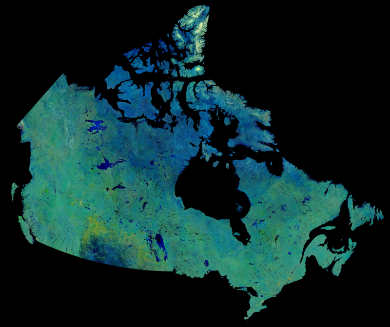
Text version
Relief map of Canada: A map showing Canada's relief with a colour ramp to show elevation ranges. Colour tints of depth ranges show ocean bathymetry. Credit: Canada Centre for Mapping and Earth Observation, Natural Resources Canada
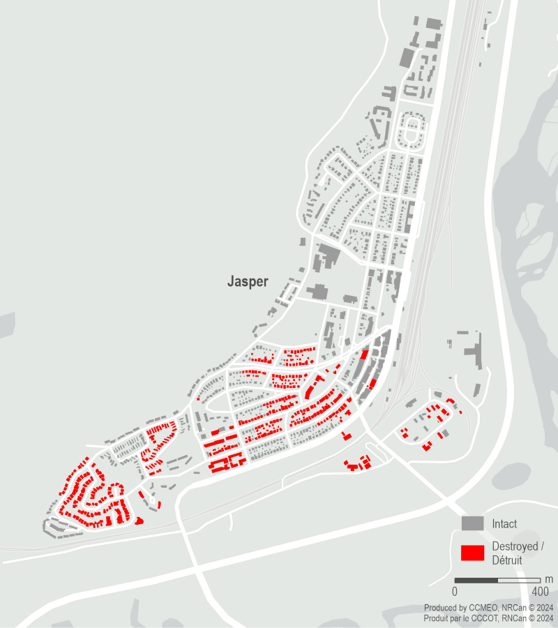
The Emergency Geomatics Service (EGS) of the Canada Centre for Mapping and Earth Observation (CCMEO) conducted a rapid damage assessment following the Jasper, Alberta wildfire on July 22, 2024. High-resolution Canadian and commercial synthetic aperture radar (SAR) data, capable of penetrating smoke and cloud cover, were used to identify damaged infrastructure, showing ~98% agreement with in-situ data from the Municipality of Jasper. The first cloud-free high-resolution optical satellite image was only collected eight (8) days after the wildfire impacted the town, highlighting the importance of SAR data in assessing damage during emergency wildfire situations.
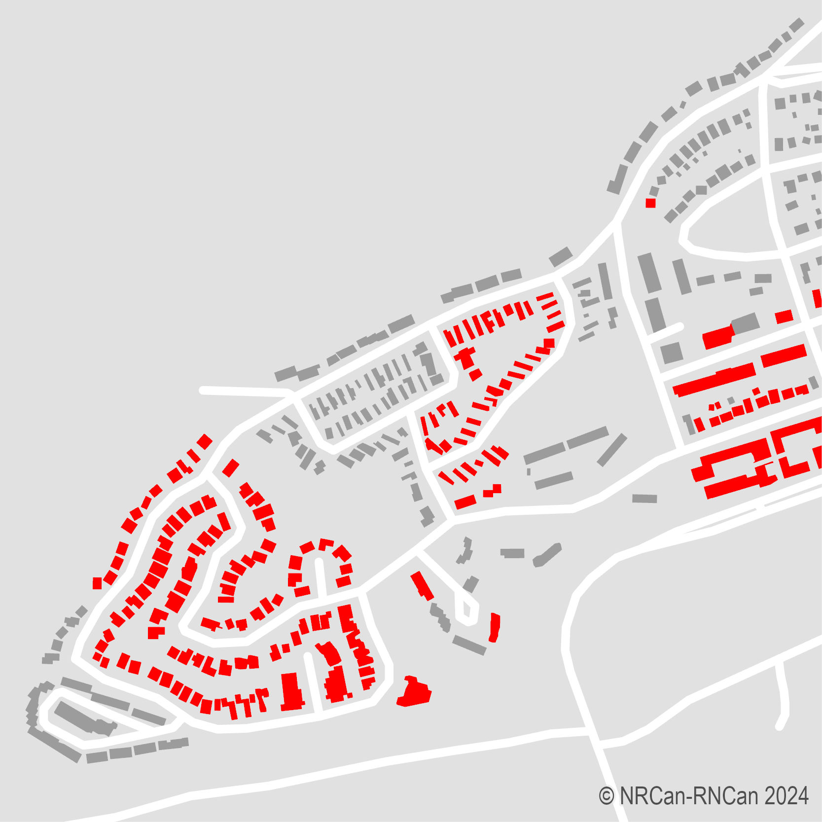
Image A
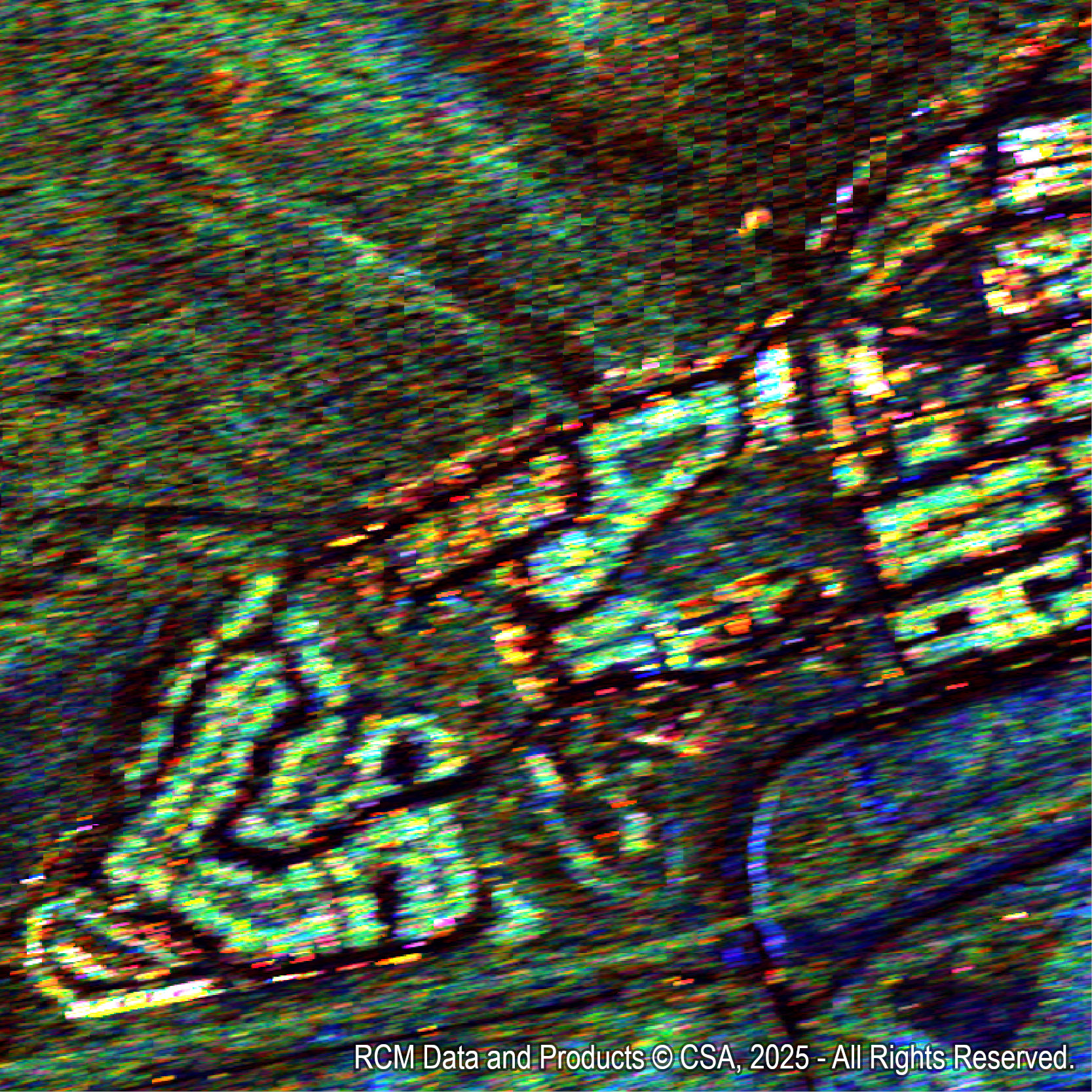
Image B
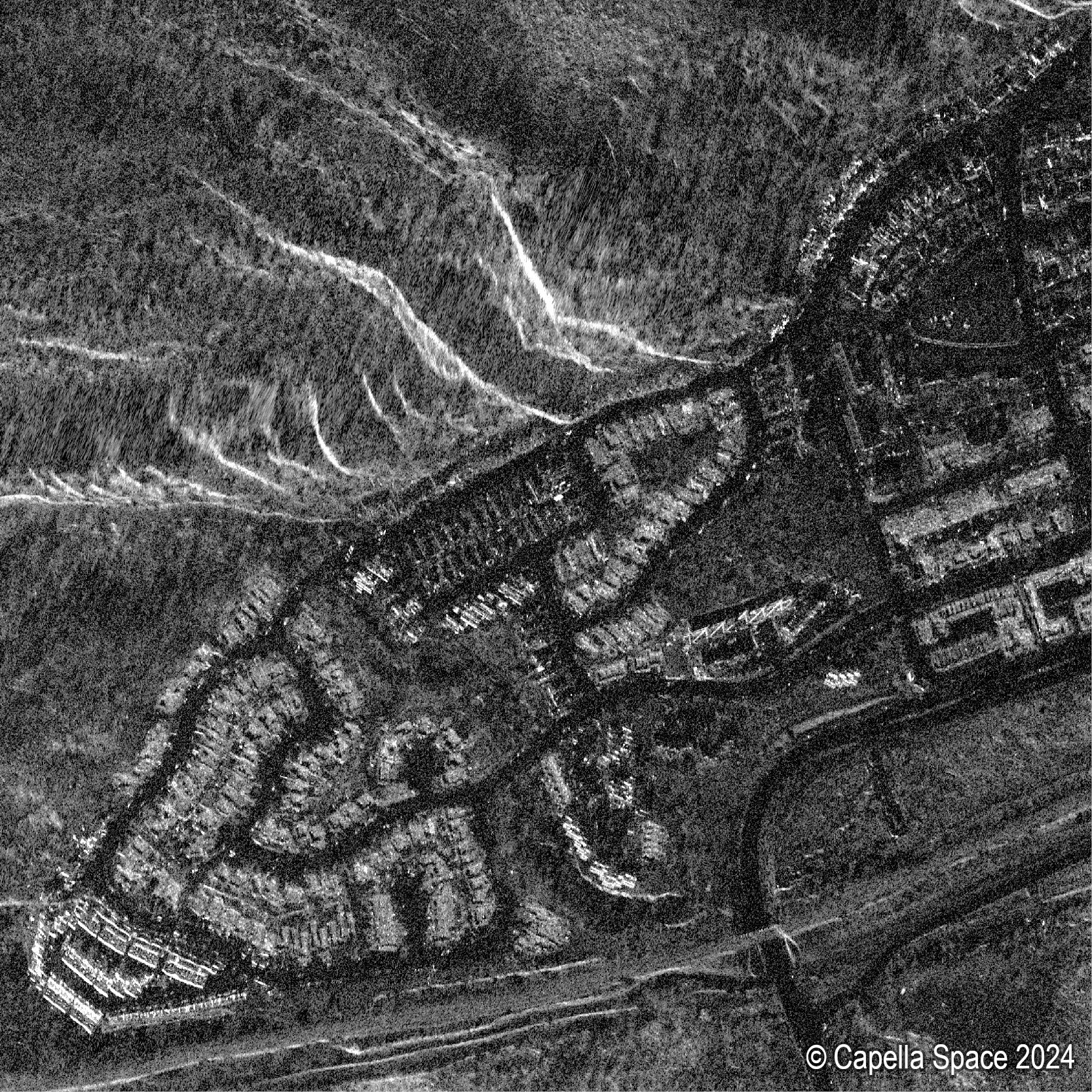
Image C
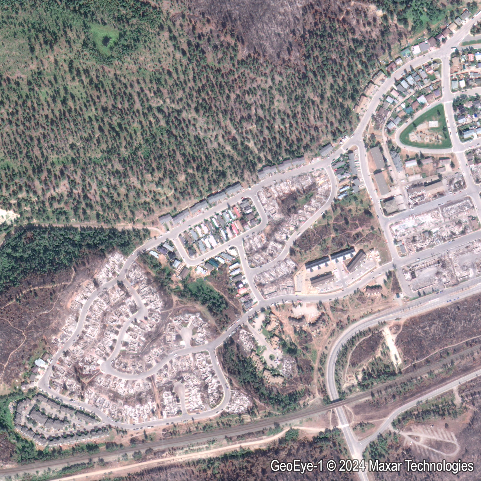
Image D
Image descriptions
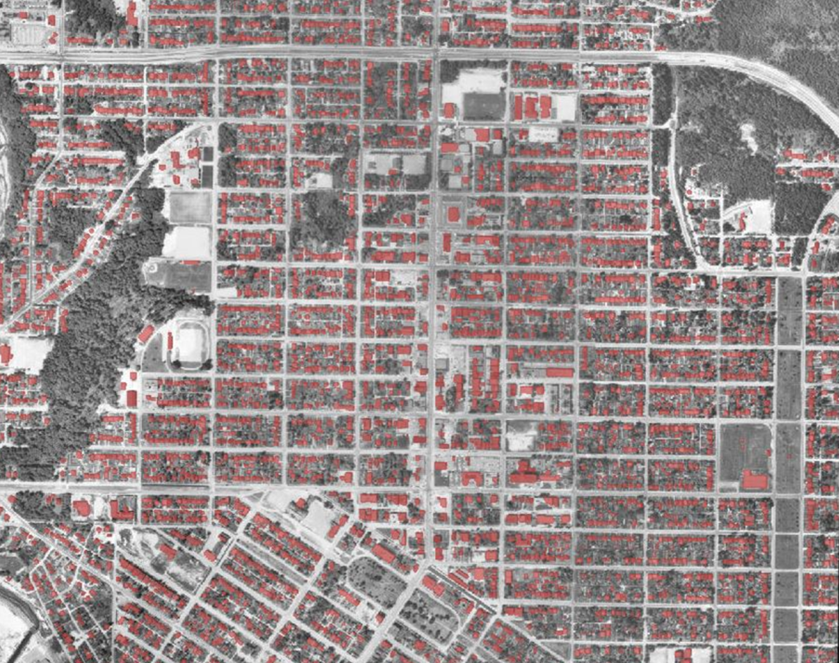
Image A: A map of CCMEO EGS’ rapid damage assessment of a Jasper neighbourhood showing structures destroyed by wildfire in red, and intact structures in grey.
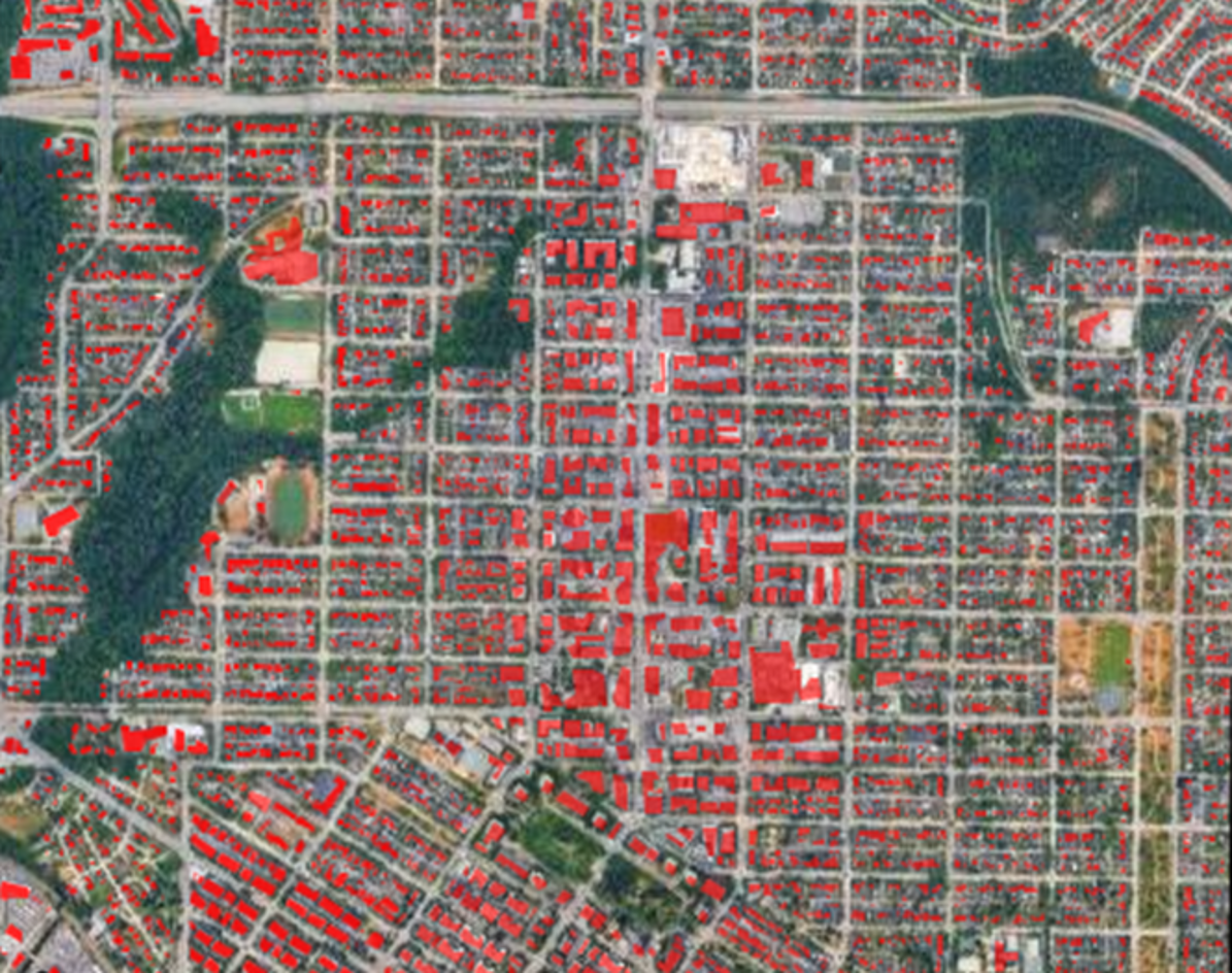
Image B: A Radarsat Constellation Mission (RCM) satellite image of the same Jasper neighbourhood, which helped EGS distinguish between destroyed and intact structures.
Image C: A very high-resolution synthetic aperture radar satellite image of the same Jasper neighbourhood used to confirm analysis of the RCM image.
Image D: The first cloud-free high-resolution optical satellite image of the same neighbourhood.
About this strategy: Why now?
Canada stands at a pivotal moment because geospatial systems have become essential digital public infrastructure. That infrastructure underpins economic competitiveness, resilient communities, environmental sustainability, and public trust.Footnote 1
Advances in satellite Earth observation, artificial intelligence (AI), cloud computing, and real-time sensor networks now enable Canada to
- map wildfire spread in near-real time
- model flood risk with centimetre-scale precision
- optimize agricultural production across millions of hectares
- plan major infrastructure using immersive 3D digital twins.
Previously, geospatial information was the domain of specialists. But times have changed. The new reality is that geospatial information and intelligence are now central to virtually every function of government and society. It has transformed how governments, businesses, communities, and individuals make decisions.
Building a common operating picture for emergencies: Yukon GeoResilience
Yukon faces unique challenges in emergency management, from wildfires to floods, often compounded by limited infrastructure and connectivity. In response, the Government of Yukon has invested in a digital transformation of its emergency management systems, bringing together geomatics and emergency measures into a unified platform.
Through Geomatics Yukon and the Emergency Measures Organization, the territory has created a common operating picture that integrates situational awareness, damage assessments, and critical infrastructure data. The old system that relied on paper maps and ad hoc file sharing has evolved into an interactive, real-time digital mapping system.
The benefits of the common operating picture are clear. It enables faster coordination across agencies, better resource allocation, and improved resilience in responding to major incidents. Challenges remain, including gaps in critical infrastructure datasets and the need for long-term funding and support. Yet, Yukon’s progress demonstrates how modernized SDI strengthens emergency response and can serve as a model for other jurisdictions across Canada.

Text version
Dashboard of Yukon’s emergency management system. Events are identified on a satellite picture and important news are presented.
Although Canada is a vast and diverse country, collecting geospatial data is no longer the biggest challenge. Numerous federal government departments, thirteen provincial and territorial governments, hundreds of Indigenous governments, municipalities, public institutions, and private companies, Academia, and individuals generate and use location-based data for everyday functions from navigation apps and property transactions to emergency alerts and environmental monitoring.
As the number of data sources grows, the real challenge is coordinating this information, connecting it across jurisdictions and with non-government sources, and ensuring it is trusted, privacy-protected, respectful of Indigenous data sovereignty, and increasingly, usable in real time.
Countries around the world are modernizing their geospatial ecosystems to support national priorities and shared global challenges such as climate adaptation, disaster risk reduction, sustainable development, and secure digital trade. Canada benefits when we align with international best practices and interoperability standards. The benefits include strengthening Canada’s economic position, enhancing cross-border collaboration, and ensuring that Canadian innovations contribute meaningfully to the global geospatial community.
However, Canada’s current geospatial governance, legal, policy, and funding structures were developed in an era of static mapping and limited data integration. They cannot accommodate the dramatic increase in the number of geospatial data producers and users, the explosion of data, and the pace at which technology is transforming. As such, there is duplication, underuse of valuable assets, and missed opportunities for coordinated action.
Modernizing Canada’s SDI is essential so we can harness the full value of geospatial intelligence, deliver services more efficiently, support innovation, and prepare Canada for future challenges and opportunities.
Canada’s FPT governments play a distinct and essential role in improving the SDI by managing Canada’s national geospatial assets and services, coordinating the SDI, and stewarding Earth observation systems, geodetic networks, and foundational datasets to ensure long-term integrity, sovereignty, and integration (Refer to Figure 1).
Guided by the 2025–2030 Canadian Geomatics Accord, the strategy calls for renewed collaboration, inclusive partnerships, and shared investment in Canada’s geospatial future. It provides an enabling framework that unites partners in a common commitment while respecting the diversity of needs, capacities, mandates, authorities, and readiness.
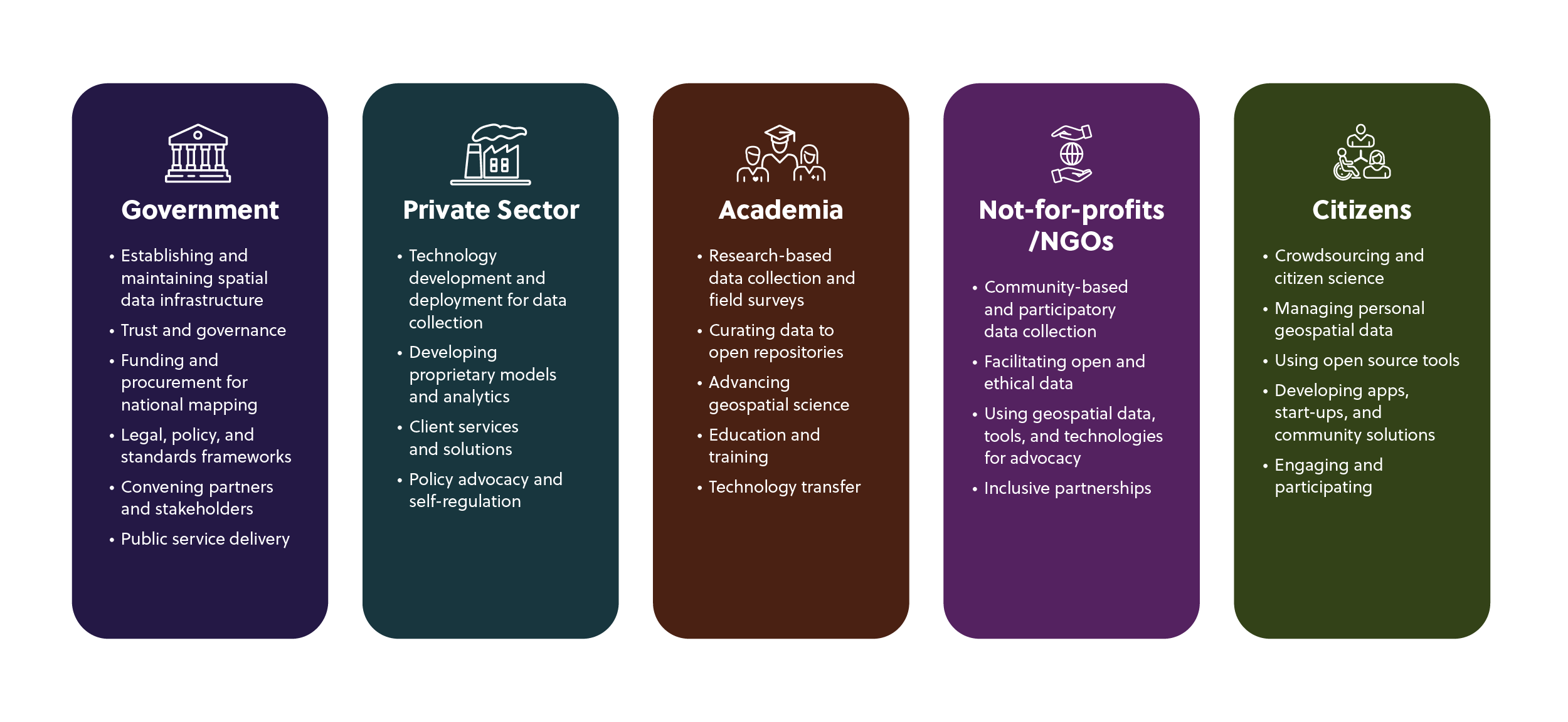
Text version
-
Government
- Establishing and maintaining spatial data infrastructure
- Trust and governance
- Funding and procurement for national mapping
- Legal, policy, and standards frameworks
- Convening partners and stakeholders
- Public service delivery
-
Private sector
- Technology development and deployment for data collection
- Developing proprietary models and analytics
- Client services and solutions
- Policy advocacy and self-regulation
-
Academia
- Research-based data collection and field surveys
- Curating data to open repositories
- Advancing geospatial science
- Education and training
- Technology transfer
-
Not-for-profits/NGOs
- Community-based and participatory data collection
- Facilitating open and ethical data
- Using geospatial data, tools, and technologies for advocacy
- Inclusive partnerships
-
Citizens
- Crowdsourcing and citizen science
- Managing personal geospatial data
- Using open source tools
- Developing apps, start-ups, and community solutions
- Engaging and participating
A key component of the strategy is to equip and enable governments to deliver on priorities and commitments, including energy transition, nation-building, economic growth, and reconciliation with Indigenous Peoples. Canada’s SDI underpins these ambitions. Geospatial data is the connective tissue of modern policy from clean electricity systems to land-use planning for major infrastructure corridors.
From 2026 to 2031, this strategy will guide actions that improve services, protect communities, advance inclusive planning, and safeguard Canada’s spatial assets and sovereignty for future generations.
What we heard
This strategy is the result of a two-year effort (2024–2025) led by CCOG. The first step was to conduct an internal FPT stock take of the current state of Canada’s SDI. The next step was to consult the wider geospatial community to identify future requirements for a modernized SDI (Refer to Figure 2).
CCOG is committed to continued collaboration with geospatial producers and users across all sectors as we implement this strategy.
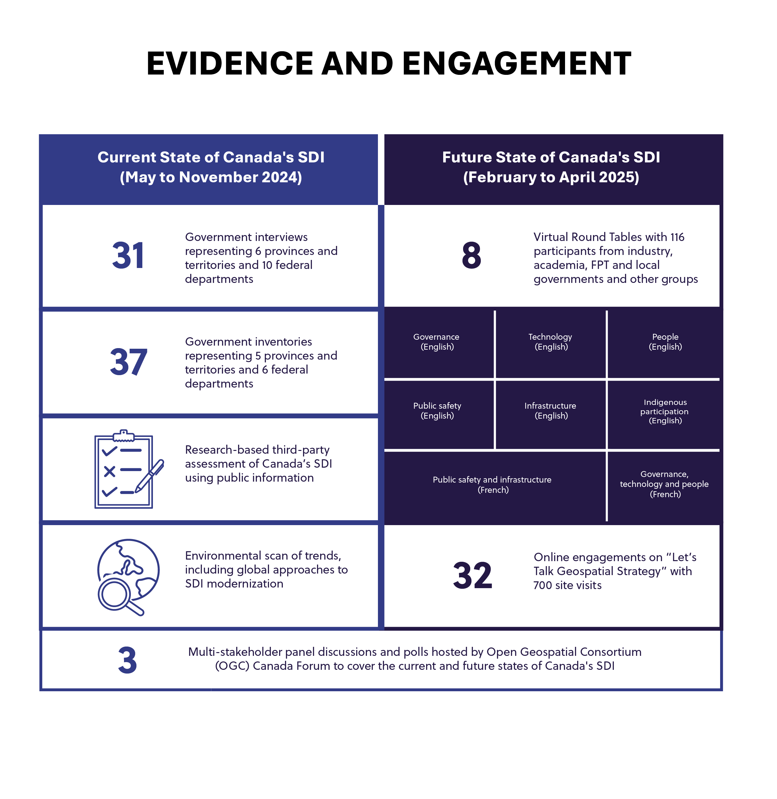
Text version
-
Current state of Canada’s SDI (May to November 2024)
- 31 government interviews representing 6 provinces and territories and 10 federal departments
- 37 government inventories representing 5 provinces and territories and 6 federal departments
- Research-based third-party assessment of Canada’s SDI using public information
- Environmental scan of trends, including global approaches to SDI modernization
-
Future state of Canada’s SDI (February to April 2025)
-
8 Virtual Round Tables with 116 participants from industry, academia, FPT and local governments and other
groups
- Governance (English)
- Technology (English)
- People (English)
- Public safety (English)
- Infrastructure (English)
- Indigenous participation (English)
- Public safety and infrastructure (French)
- Governance, technology and people (French)
- 32 online engagements on “Let’s Talk Geospatial Strategy” with 700 site visits
- 3 multi-stakeholder panel discussions and polls hosted by Open Geospatial Consortium (OGC) Canada Forum to cover the current and future states of Canada's SDI
-
8 Virtual Round Tables with 116 participants from industry, academia, FPT and local governments and other
groups
The insights collected from the stock take analysis and from partner and stakeholder engagement sessions (refer to figures 3 and 4) helped focus the strategy missions and priority areas.
The strategy aims to:
- Modernize Canada’s geospatial infrastructure by replacing fragmented systems with user-friendly solutions that enable seamless data sharing and collaboration across jurisdictions, organizations, and sectors
- Deliver measurable public value by unlocking the potential of geospatial data to drive innovation, improve public services, and strengthen evidence-based decision-making
- Foster inclusive geospatial governance by removing institutional silos and updating policy, legal, and standards frameworks to improve interoperability, data integration, and participation across Canada’s geospatial ecosystem
- Stimulate sustainable investment in foundational data, cloud platforms, real-time services, workforce development, and innovation ecosystems to keep Canada at the forefront of geospatial technology
- Advance reconciliation and inclusion by working with Indigenous partners to determine appropriate approaches for embedding Indigenous data sovereignty principles in geospatial frameworks
- Equip under-represented communities, particularly Indigenous, rural, and northern, with the tools, training, and infrastructure to participate equitably in Canada’s geospatial future.
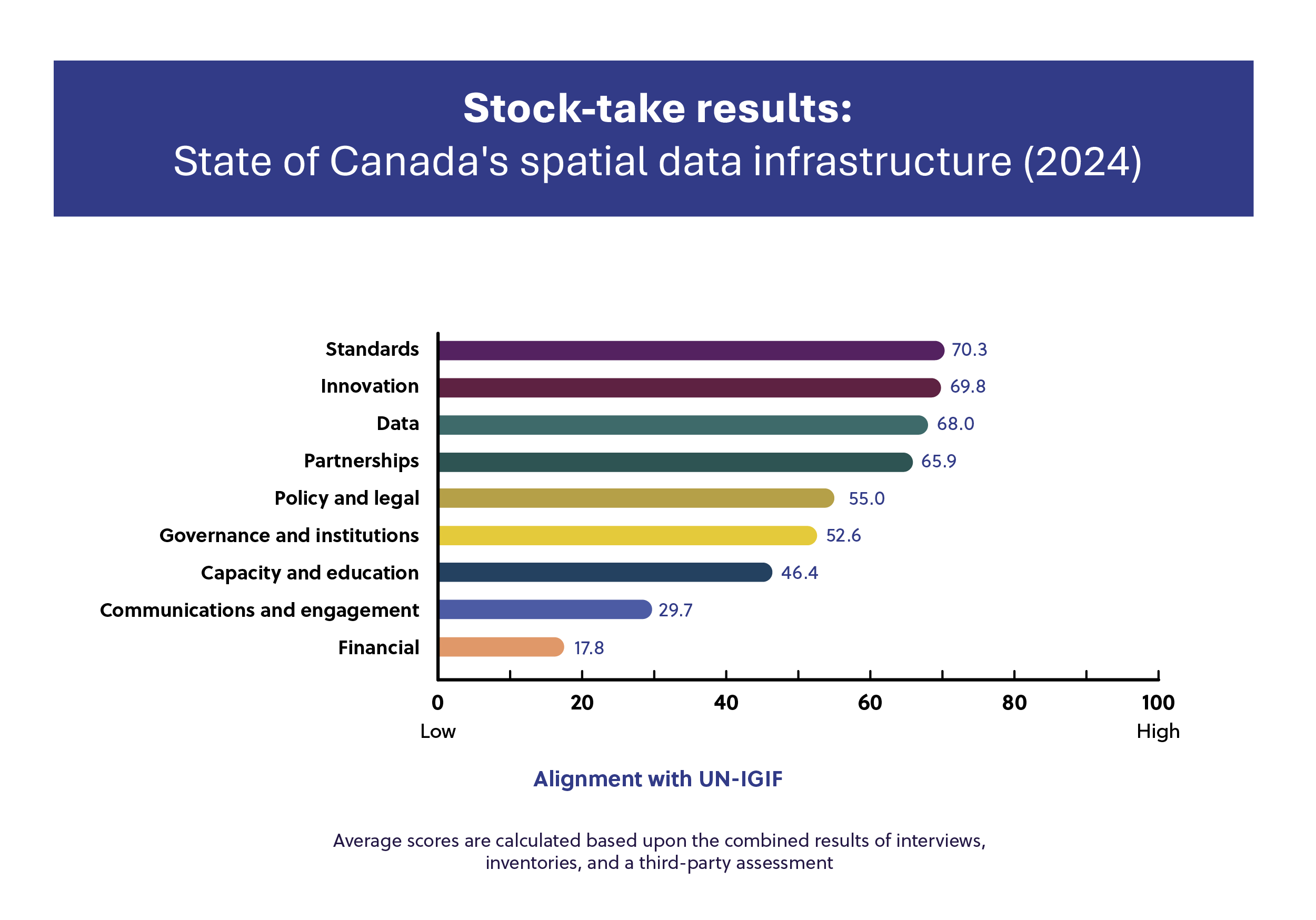
Text version
| Strategic pathways of Canada’s SDI | Alignment with UN-IGIF (Average scores are calculated based upon the combined results of interviews, inventories, and a third-party assessment) |
|---|---|
|
Standards |
70.3 |
|
Innovation |
69.8 |
|
Data |
68.0 |
|
Partnerships |
65.9 |
|
Policy and legal |
55.0 |
|
Governance and institutions |
52.6 |
|
Capacity and education |
46.4 |
|
Communication and engagement |
29.7 |
|
Financial |
17.8 |
*Scores were determined based upon evaluation of results from FPT interviews and inventories, and a third-party assessment using publicly available information. Scores indicate the degree to which the elements of Canada’s SDI were aligned with the United Nations Integrated Geospatial Information Framework (UN-IGIF). The UN-IGIF is a mechanism for describing and demonstrating national leadership in geospatial information management and the capacity to take positive steps for improvement.
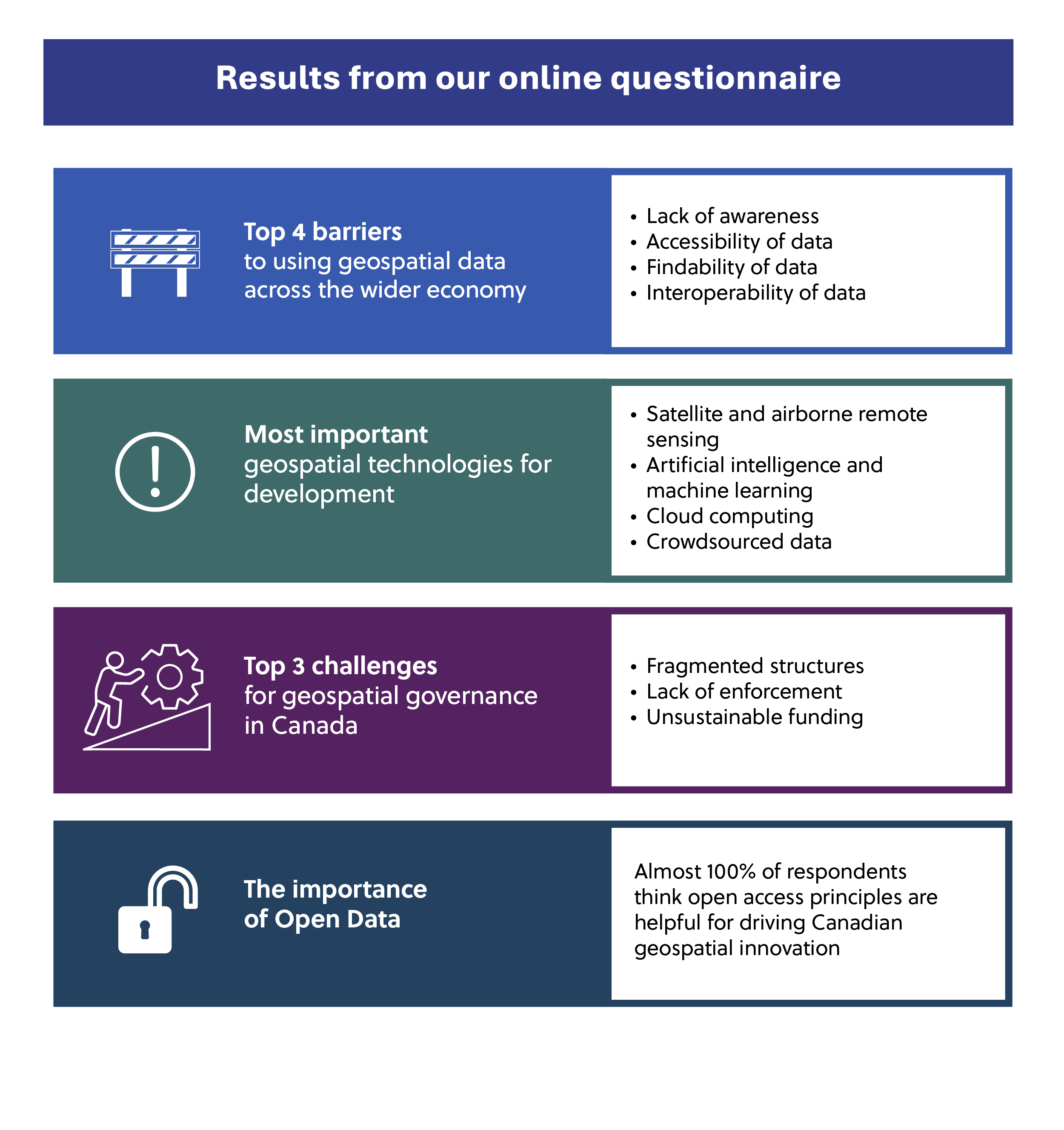
Text version
Top 4 barriers to using geospatial data across the wider economy
- Lack of awareness
- Accessibility of data
- Findability of data
- Interoperability of data
Most important geospatial technologies for development
- Satellite and airborne remote sensing
- Artificial intelligence and machine learning
- Cloud computing
- Crowdsourced data
Top 3 challenges for geospatial governance in Canada
- Fragmented structures
- Lack of enforcement
- Unsustainable funding
The importance of Open Data
- Almost 100% of respondents think open access principles are helpful for driving Canadian geospatial innovation
Our vision
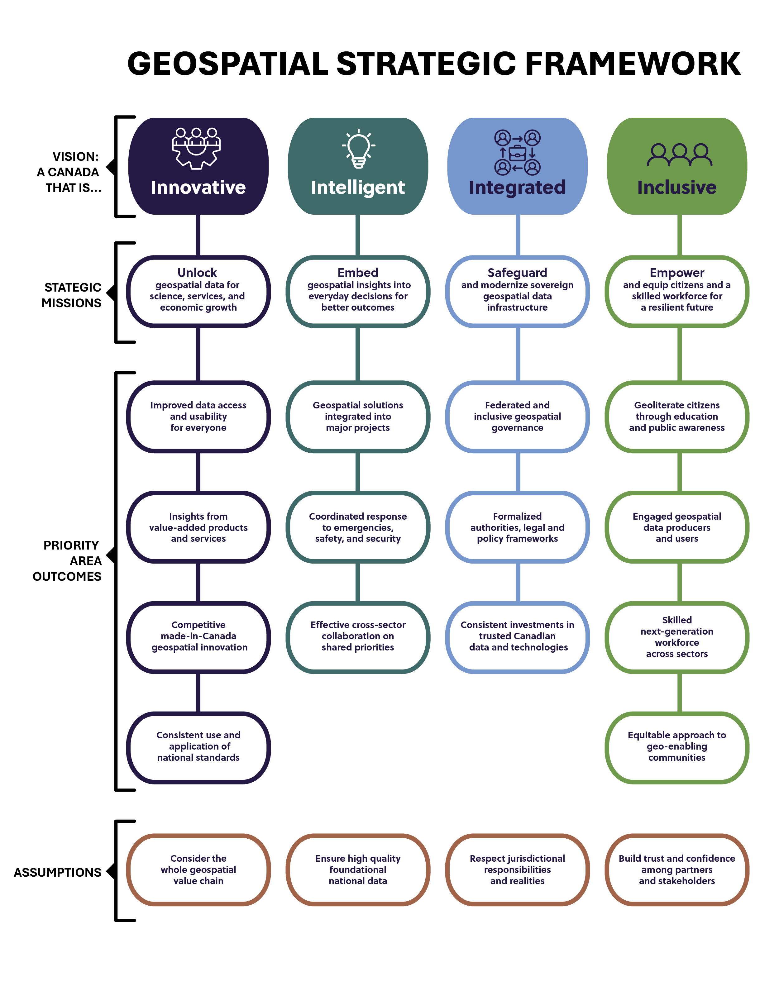
Through modernization of Canada’s geospatial ecosystem, we envision a Canada that is:
- Innovative in developing and applying emerging geospatial technologies, creative partnerships, and new ways of working to unlock the full potential of geospatial data to drive economic growth, environmental stewardship, and social benefits
- Intelligent in embedding insights from high-quality, trusted geospatial data into decision-making, policy guidance, investment considerations, and risk management across all sectors, enabled by a geo-literate workforce and public
- Integrated in our efficient and collaborative response to shared challenges through sovereign infrastructure and geospatial solutions that connect data, governance, and tools seamlessly across jurisdictions, sectors, and borders
- Inclusive in better serving and empowering all data users, including Indigenous and under-represented communities, by embedding diverse perspectives and knowledge systems into Canada’s geospatial governance and services.
Text version
Vision: A Canada that is …
Innovative
- Strategic mission: Unlock geospatial data for science, services, and economic growth
-
Priority area outcomes
- Improved data access and usability for everyone
- Insights from value-added products and services
- Competitive made-in-Canada geospatial innovation
- Consistent use and application of national standards
Intelligent
- Strategic mission: Embed geospatial insights in everyday decisions for better outcomes
-
Priority area outcomes
- Geospatial solutions integrated into major projects
- Coordinated response to emergencies, safety, and security
- Effective cross-sector collaboration on shared priorities
Integrated
- Strategic mission: Safeguard and modernize sovereign geospatial data infrastructure
-
Priority area outcomes
- Federated and inclusive geospatial governance
- Formalized authorities, legal, and policy frameworks
- Consistent investments in trusted Canadian data and technologies
Inclusive
- Strategic mission: Empower and equip citizens and a skilled workforce for a resilient future
-
Priority area outcomes
- Geoliterate citizens through education and public awareness
- Engaged geospatial data producers and users
- Skilled next-generation workforce across sectors
- Equitable approach to geoenabling communities
Assumptions
- Consider the whole geospatial value chain
- Ensure high quality foundational national data
- Respect jurisdictional responsibilities and realities
- Build trust and confidence among partners and stakeholders
Success in achieving this vision is grounded in the following assumptions:
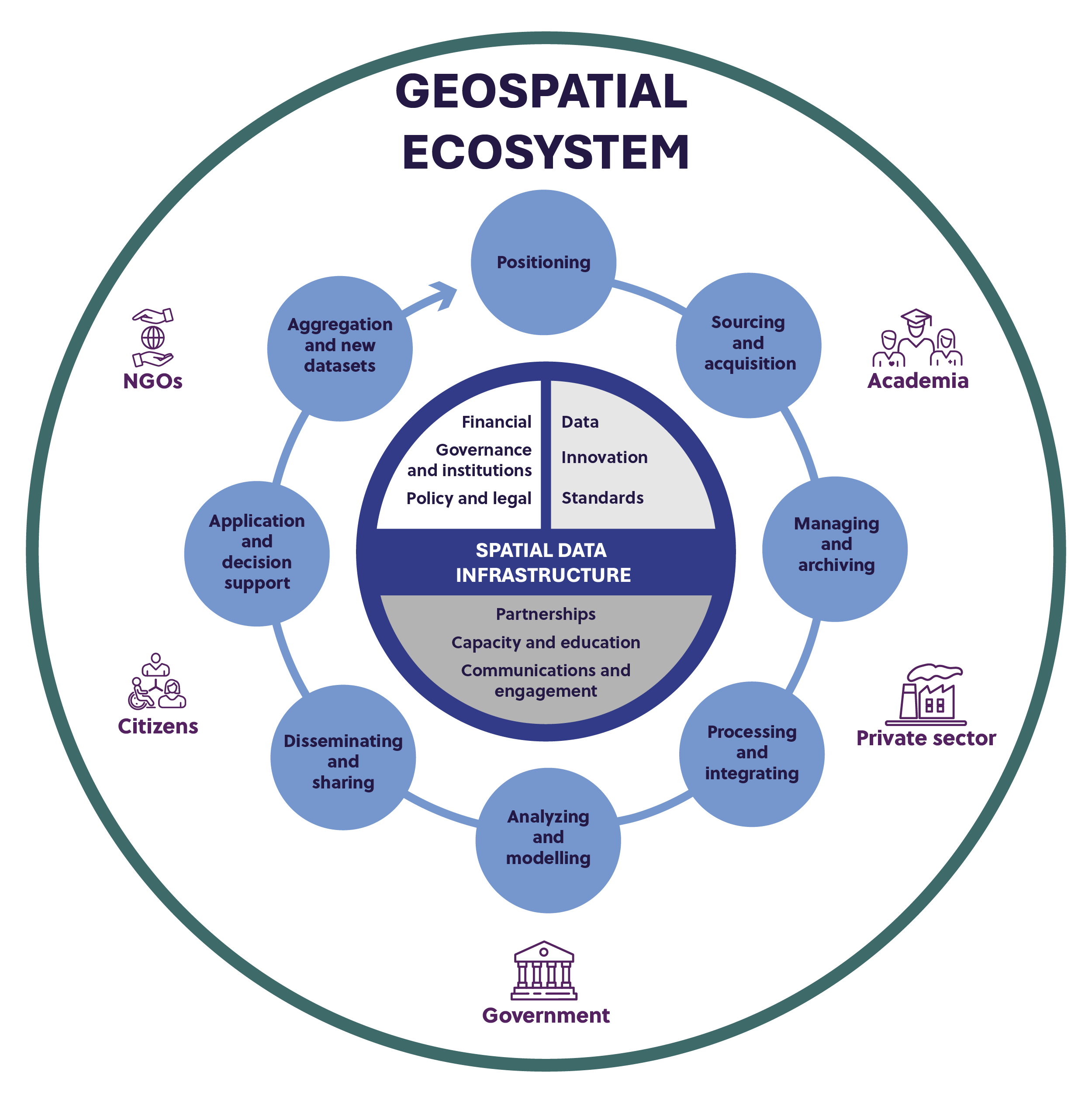
Unlocking the whole geospatial value chain
A geospatial value chain describes how data are acquired, processed, combined, transformed into intelligence, and reused by producers and users across Canada’s geospatial ecosystem (Refer to Figure 6).
By modernizing our SDI, this strategy ensures that data — from Earth observation and field surveys; through integration and standards alignment; to delivery via application programming interfaces and dashboards — is seamless, reliable, and ready for use.
By streamlining each link in the value chain, investments in modernization turn “raw” geospatial information into actionable insights that deliver measurable social, environmental, and economic benefits for Canadians.
Text version
Graphic showing three concentric layers of Canada’s Geospatial Ecosystem, with the Spatial Data Infrastructure at the centre (data, innovation, standards, partnerships, capacity and education, communications and engagement, financial, governance and institutions, policy and legal) surrounded by elements of the geospatial value chain (positioning, sourcing and acquisition, managing and archiving, processing and integrating, analyzing and modelling, disseminating and sharing, application and decision support, aggregation and new datasets), and the major players in the geospatial ecosystem positioned around the value chain (academia, private sector, government, citizens, NGOs).
Ensuring the availability of high quality foundational national data
National location-based datasets are essential public infrastructure that enables better outcomes, from planning safe and resilient communities to advancing nation-building projects such as clean-energy systems and transportation corridors. These datasets are public goods created and shared by governments and are the foundation of Canada’s modern geospatial ecosystem.
Foundation for national geospatial data and services: The Canadian Spatial Reference System
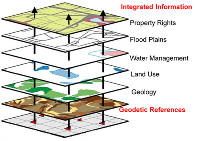
Every decision that depends on location, whether guiding aircraft, mapping wildfire spread, or building a new transit corridor, relies on precise coordinates. Canada’s Canadian Spatial Reference System (CSRS) provides that common foundation by defining latitude, longitude, and elevation (also known as heights above sea level) across the country. These geodetic references must be updated because the Earth shifts and technologies evolve. All jurisdictions apply the updates in a coordinated fashion to ensure accuracy and interoperability across government, industry, and everyday services. For example, consistent water levels and land uplift rates from the CSRS are essential for water management, flood modelling, and long-term sea and lake level estimates.
The CSRS is maintained through the Canadian Geodetic Reference System Committee, which is a federal-provincial group that has coordinated standards for more than 30 years. It is led by Natural Resources Canada in collaboration with the provinces, territories, and municipalities. This shared system allows jurisdictions to link their infrastructure and data to authoritative values, ensuring consistency from coast to coast to coast.
Canada is now preparing a major CSRS modernization in partnership with the United States, with provinces and territories planning to align by 2030. This marks the first time in decades that Canada and the United States will share a common definition of heights above sea level. This update will facilitate and improve transboundary water management. It will also strengthen sovereignty, support innovation such as autonomous vehicles, and safeguard the reliability of geospatial services for all Canadians.
Text version
Multiple geographical data layers overlapping to create a detailed map. Top to bottom: Integrated information, property rights, flood plains, water management, land use, geology, geodetic references.
Respecting jurisdictional responsibilities and realities
As we carry out this strategy, CCOG will strive for more effective collaboration as the core of a resilient geospatial ecosystem. The strategy supports collective work through shared initiatives, and alignment of investments, standards, and operational models where possible. The strategy respects the unique mandates, authorities, capacities, and financial realities of each partner.
The strategy is designed to be scalable to deliver short-term results and long-term transformation. It focuses on leveraging existing tools, expanding proven models, and aligning with the practical realities faced by different partners. Jurisdictions can be leaders in different areas of strength while also collaborating to achieve an integrated, seamless digital infrastructure.
Building trust and confidence among partners and stakeholders
Having the trust of the public and partners depends on both the quality of data and how the vision is carried out.
We will maintain transparent, ongoing engagement with partners and stakeholders. In particular, we aim to strengthen engagement with Indigenous governments and organizations. The goal is to determine respectful and appropriate approaches for co-developing solutions that address gaps and ensure that technology serves people and promotes ethical outcomes.
CCOG will also work with international organizations and governments in areas such as standards development to share and implement best practices. We will collaborate globally in such areas as Arctic data to strengthen interoperability, knowledge exchange, and opportunities for Canadian innovation and trade within a sustainable global geomatics sector.
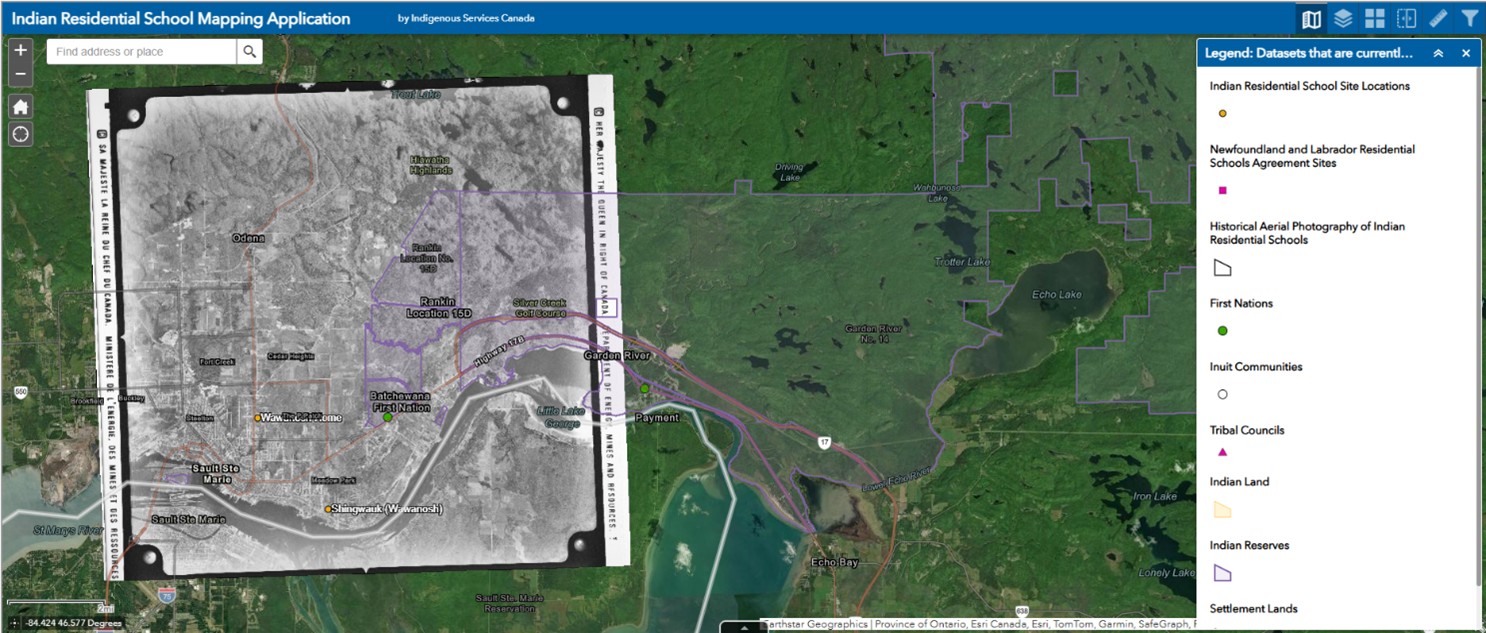
Mapping truth: Indian Residential Schools Interactive Map
Geospatial tools can play an important role in reconciliation with Indigenous Peoples. To support truth-telling and healing, Indigenous Services Canada, in consultation and engagement with the National Centre for Truth and Reconciliation and Indigenous partners, developed the Indian Residential Schools Interactive Map.
The map shows the location of 140 former residential school sites recognized under the Indian Residential Schools Settlement Agreement, along with their status and historical context. Users can explore each site, access photographs from Natural Resources Canada’s National Air Photo Library and compare historic and current imagery through an interactive web interface. The historical air photos of each residential school were made accessible to a wide range of users through an innovative national scale Web Map Service imagery layer. In this layer, tiled images can be added seamlessly and quickly rendered in any mapping interface. Static maps are also available for users in remote or northern low-bandwidth areas and for ready use in presentations, school settings and ceremonies.
This initiative demonstrates the power of Canada’s SDI to connect authoritative data, historic imagery, and Indigenous knowledge in a respectful and accessible way. Canada shows how geospatial services can advance reconciliation and strengthen public trust in shared digital infrastructure by embedding Indigenous data sovereignty principles and providing tools that communities value for healing and memorialization.
A framework for action
Strategic mission 1. Unlock
Improve geospatial data products and access to enable and maximize science, innovation, and economic growth
Geospatial data and technologies are transformative, providing solutions and productivity improvements for science, public services, and businesses across diverse sectors of the economy. This strategic mission will enhance the acquisition, development, discoverability, interoperability, and accessibility of authoritative foundational data and value-added data products.
The goal is to unlock their full value and ensure that Canada, its geospatial industry, and other connected economic sectors are Innovative.
Priority areas
Modernize geospatial data access and usability
The proliferation of data sources and portals has made it difficult for users to locate the right, trusted high-quality data for their needs. We will modernize workflows, leverage machine-to-machine communication, and advance flexible, AI-enabled discovery and access tools (for example, Geo.ca).
These tools will integrate data from multiple sources, meet diverse user needs, and reduce technical barriers. They will ensure high-quality data can be easily found, understood, and applied by technical users and generalists alike.
We will extend digital transformation to ensure the usability and relevance of foundational information for a wide array of decision-making needs.
In addition, we will promote greater awareness across governments of how geospatial tools and insights can support mandates, as some departments and agencies remain unfamiliar with the full potential of geospatial information.
By pairing awareness with modernization, we will ensure that geospatial data is both accessible and actively used to improve decision-making and public services.
Keeping an eye on the forest: Satellite monitoring of Canada’s afforestation efforts
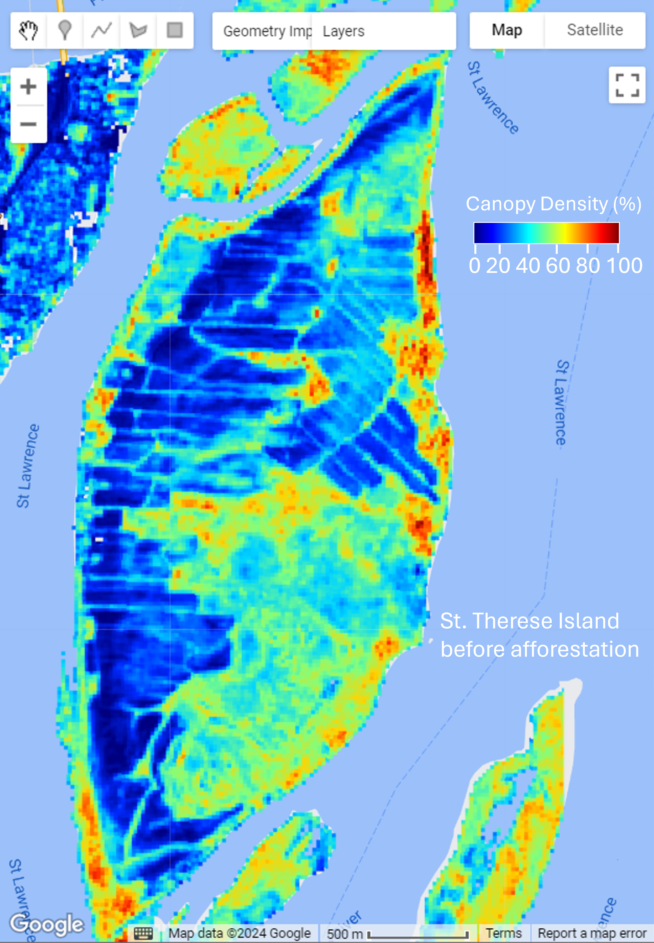
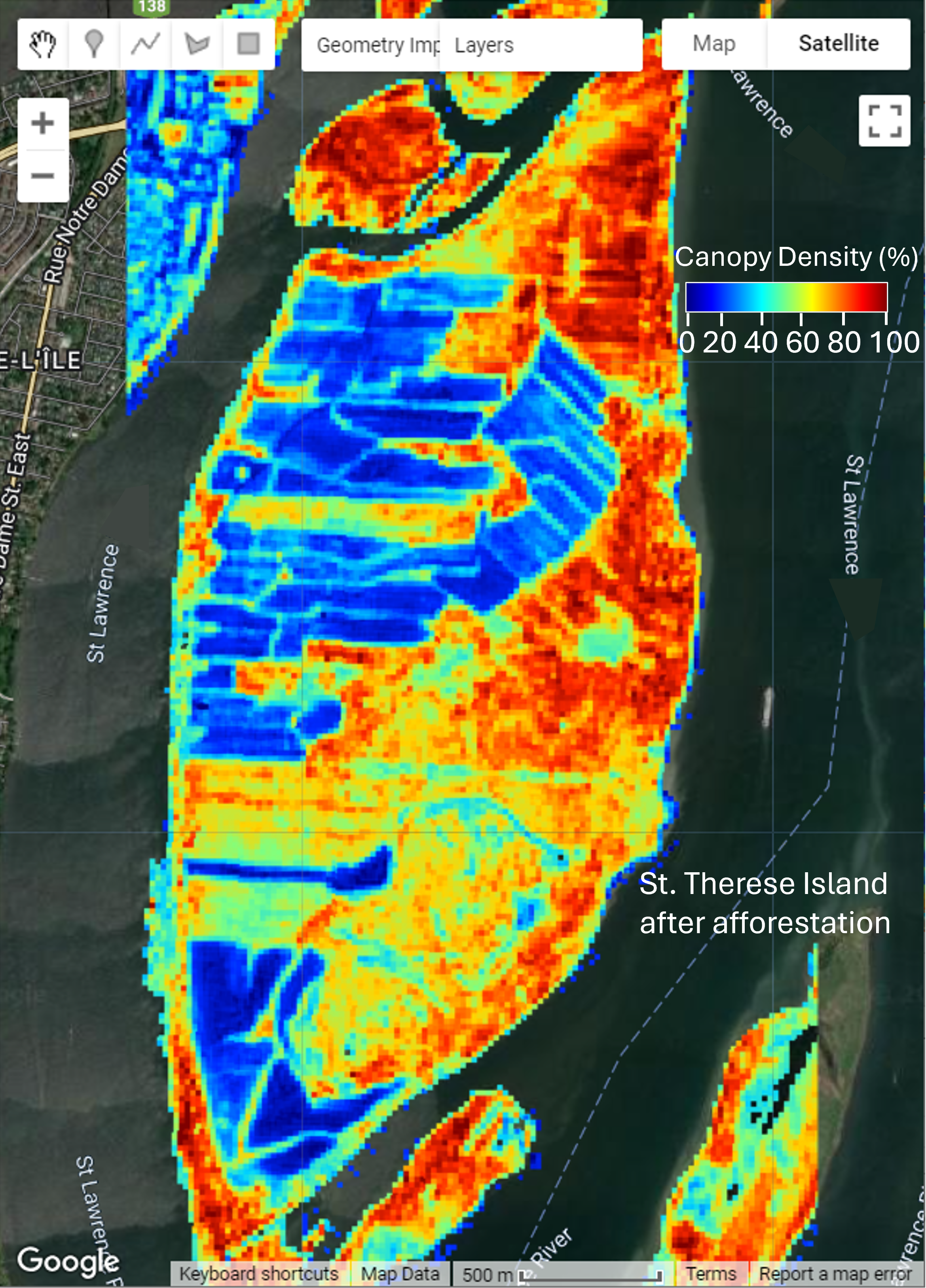
St Therese Island – Before and After Afforestation. Produced by the Canada Centre for Mapping and Earth Observation, Natural Resources Canada, ©2025
Afforestation is the planting of trees on land that has not historically supported forests. It strengthens natural carbon sinks, improves biodiversity and air and water quality, and provides cooling green spaces in communities.
Monitoring the growth and condition of these trees is essential but expensive to perform through field surveys alone. Scientists at NRCan’s Canada Centre for Mapping and Earth Observation and the Canadian Forest Service developed an innovative, satellite-based solution to address this. Their LEAF Toolbox is a free and open-source AI model. They used LEAF to analyze time-series imagery across more than 1,000 afforestation sites in southern Ontario. The tool achieved over 85% accuracy in detecting vegetation cover and density. It indicated that more than 95% of the sites were growing as expected.
This scalable geospatial approach, built on open satellite data and machine learning, now supports ongoing monitoring of afforestation, including through projects funded through the 2 Billion Trees program, demonstrating how Canada’s SDI turns earth observation data into actionable insights for climate resilience and ecosystem restoration.
Create value-added geospatial data products and services
Advanced technologies such as AI and ML are enabling users to generate insights from complex data. We will focus on user needs to design and develop new downstream geospatial products that leverage analysis-ready data and toolboxes to provide real-time and predictive intelligence, decision-support, and insights that go beyond foundational mapping.
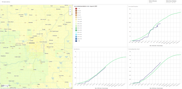
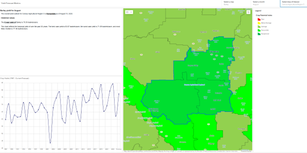
Value-added products for decision support: Actionable intelligence for farmers and policymakers
Agriculture underpins Canada’s food security and economy. It is highly sensitive to the effects of weather, climate, and pests. Agriculture and Agri-Food Canada developed the Canadian Crop Metrics application to help producers, researchers, and policymakers make timely decisions.
This geospatial tool integrates satellite imagery, climate data, and pest and risk indicators into interactive maps and dashboards. It allows users to compare current growing conditions with historical trends across 14 major crops, providing near real-time insight into yield prospects and production risks. Forecasts are refined monthly during the growing season, combining models trained on Statistics Canada data with climate and satellite observations.
For producers, these insights can inform resource allocation, agronomic practices, and marketing. For policymakers, they support decisions on environmental programs, transportation planning, and trade. By making value-added geospatial products accessible, the Canadian Crop Metrics application illustrates how Canada’s spatial data transforms raw data into actionable intelligence that strengthens both farm-level resilience and national policy planning.
Strengthen made-in-Canada geospatial innovation
Canada’s geospatial industry and research institutions drive productivity and innovation across the economic sectors. This requires a vibrant innovation ecosystem that has dedicated funding for geospatial innovation, partnerships, and targeted support for small and medium-sized enterprises and Indigenous businesses.
In support of this, we will enhance innovation and partnership tools that encourage collaborative R&D and the scale up of home-grown geospatial solutions. This includes refreshing the terms of the GeoConnections program led by the Canada Centre for Mapping and Earth Observation (CCMEO).
GeoConnections: Driving innovation in Canada’s geospatial infrastructure
The GeoConnections program, led by Natural Resources Canada, has been a catalyst for modernizing the Canadian Geospatial Data Infrastructure (CGDI) for over two decades. The program supports governments, academia, Indigenous organizations, and private-sector innovators. Through cost-shared contribution funding these partners develop new geospatial tools, standards, and applications that make data more accessible, interoperable, and useful for decision-making.
Recent projects funded by GeoConnections have demonstrated the transformative potential of geospatial innovation. One project created open databases that track greenhouse gas emissions across municipalities. Another developed web tools to detect “dark vessels,” which are vessels that operate without active tracking signals near Canada’s coast. A further project enabled Indigenous communities to manage traditional place names and land-use data through cloud-based portals.
GeoConnections promotes the adoption of geospatial standards, advanced technologies such as GeoAI, digital twins, and cloud computing, and fosters collaboration across jurisdictions. The Program ensures that Canada remains at the forefront of geospatial innovation. GeoConnections exemplifies how targeted investments in SDI enable evidence-based decision-making, environmental stewardship, and economic competitiveness.
Establish a shared standards framework for Canada
Shared standards, metadata, and operational policies reduce interoperability barriers and ensure equitable data access and use. We will collaborate to establish modernized standards for location and positioning that are the foundation of the digital infrastructure within a shared framework. This includes leveraging the pending update to Canada’s Treasury Board Standard on Geospatial Data.
CCOG will promote the consistent use of geo-referencing standards that are fit-for-purpose. CCOG members will work within their jurisdictions to establish associated operational policies and implementation plans. CCOG will also look for opportunities to engage with Indigenous partners to possibly co-develop an approach to Indigenous data governance, e.g., grounded in OCAP® and CARE principles.
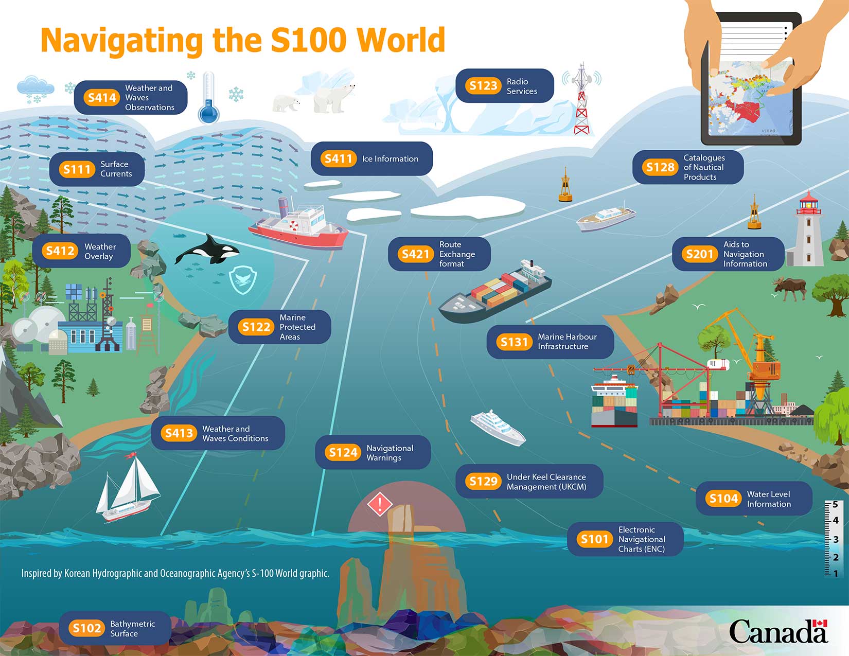
Modern navigation through geospatial innovation: The S-100 data model
Ships entering Canadian waters depend on a network of invisible data highways. These data highways guide mariners and protect coastlines by using digital nautical charts, high-resolution bathymetry, and real-time ocean observations. The economic stakes are immense because over $250 billion in goods move through Canadian waters annually. This foundation of tools is being transformed by integrating diverse marine datasets into next-generation navigation systems using the S-100 Universal Hydrographic Data Model developed by the International Hydrographic Organization.
The Canadian Hydrographic Service within Fisheries and Oceans Canada is leading the adoption of S-100. In 2025, Canada became the first nation to conduct live S-100 sea trials in the St. Lawrence River, showcasing global leadership in digital marine infrastructure.
Using the S-100 will allow mariners to access dynamic information such as seabed imagery (S-102), surface currents (S-111), and electronic navigational charts (S-101) through a single interoperable framework.
These geospatial standards are anchored in Canada’s SDI. They enable smarter route planning, reduced fuel use, and lower carbon emissions, that enhance safety, protects ecosystems, and strengthen sustainable economic growth.
Text version
Navigating the S-100 World
S-101 Electronic Navigational Chart
S-102 Bathymetric Surface
S-104 Water Level Information for Surface Navigation
S-111 Surface Currents
S-122 Marine Protected Areas
S-123 Marine Radio Services
S-124 Navigational Warnings
S-128 Catalogues of Nautical Products
S-129 Under Keel Clearance Management (UKCM)
S-131 Marine Harbour Infrastructure
S-201 Aids to Navigation Information
S-411 Ice Information
S-412 Weather Overlay
S-413 Weather and Waves Conditions
S-414 Weather and waves observations
S-421 Route Plan
Strategic mission 2. Embed
Drive greater use of geospatial data and applications across the economy and society for insights into issues that matter to Canadians
Everything happens somewhere, so location is at the heart of every decision. This strategic mission will ensure that decisions based upon geospatial insights are Intelligent by embedding geospatial data and thinking into programs, policies, and services.
The result will be better outcomes for all areas, including housing, health, reconciliation with Indigenous Peoples, emergency preparedness and response, and more.
Priority areas
Increase use of geospatial solutions to support major national and regional projects
Geospatial data and tools can accelerate the progress of large-scale projects from climate adaptation to energy transition and from urban transit to rural broadband. Trusted data strengthens planning (e.g. where to build) and reduces risks (e.g. anticipating floods).
CCOG members will work within their jurisdictions and with partners to embed geospatial data into high-profile initiatives that deliver on FPT priorities and commitments. This will ensure that location intelligence drives better design, delivery, and long-term resilience.
Turning big data into actionable insights: GeoAI
AI is transforming how Canada produces and uses geospatial information. At the CCMEO, focused R&D and partnerships with provinces, territories, and industry have led to the creation of Canada’s GeoAI Factory. This is an innovation hub that combines AI foundation models, data pipelines, and robust infrastructure.
One of its key products, the GeoAI Data Series, uses AI to rapidly generate high-accuracy data on buildings, roads, surface water, and forests from high-resolution imagery. To date, this data covers more than 560,000 square kilometres across Canada, including its largest cities and fastest-growing regions.
By comparing data over time, GeoAI supports urban change detection, housing and infrastructure monitoring, and environmental assessments. For example, change maps of Quebec City from 2002 to 2022 clearly show urban expansion. Data extracted about Victoria demonstrate the rapid production and high quality of GeoAI data. Canadians can freely access GeoAI data on geo.ca.
GeoAI demonstrates how Canada’s SDI, enhanced by AI, can deliver timely, actionable intelligence that supports housing policy, resilient infrastructure, and community well-being.
Improve geospatial coordination for emergencies, safety, and security
During crises such as floods, wildfires, and national security events, timely access to accurate geospatial data is critical for emergency preparedness, response, evacuations, and insurance.
We will enhance geospatial readiness by making it easier for partners to use and share information. This includes creating common definitions (e.g. what counts as critical infrastructure), improving communication protocols, and ensuring that data is current and easy to access.
We will also build a common view of the geospatial data and services used for emergency management operations, existing governance approaches, and coordination challenges.
This information will help us develop guidance for geospatial interoperability for emergency management to strengthen emergency response systems.
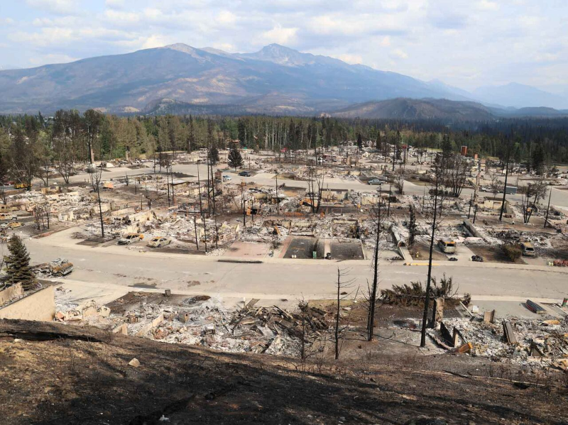
Natural disaster response: Rapid damage assessment in Jasper, Alberta
A devastating wildfire destroyed roughly one-third of the town of Jasper, Alberta, in July 2024. More than 25,000 residents and visitors had to evacuate. To support emergency managers and recovery planning, scientists from NRCan’s CCMEO conducted a rapid damage assessment using high-resolution radar imagery. The imagery came from the RADARSAT Constellation Mission (RCM) and commercial partners.
Radar can penetrate smoke and clouds and provide immediate insights when visibility is obscured. This is not possible with optical satellites. Within days, CMCEO’s assessment achieved 98% accuracy in distinguishing between destroyed and intact structures, closely matching on-the-ground municipal assessments. By contrast, the first usable cloud-free optical image was not available until eight days after the fire.
This case illustrates the vital role of Canada’s SDI in disaster response by combining satellite Earth observation, authoritative geospatial data, and federal-municipal collaboration to deliver timely intelligence. Rapid geospatial products like these are helping Canada respond more effectively to increasingly frequent and severe natural disasters.
Strengthen cross-sector collaboration
Canada must eliminate silos to increase the impact of geospatial insights.
CCOG will promote collaboration among FPT, Indigenous, academic, and private sector stakeholders and partners, encouraging adoption of interoperable geospatial data and tools within and across domains.
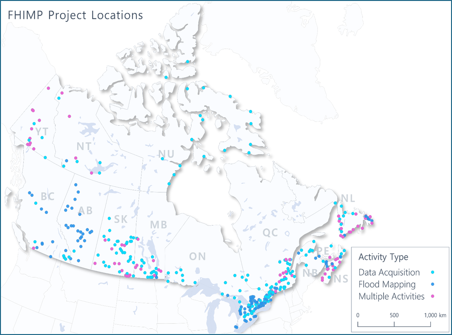
This will be accomplished by supporting joint initiatives under themes such as risk reduction, response, and recovery. We will also build on initiatives such as the Flood Hazard Identification and Mapping Program (FHIMP), which involves a cost sharing model between FPT governments and contribution funding to a range of partners.
Building safer, more resilient communities: Flood hazard mapping
Flooding is Canada’s most costly and frequent natural disaster, affecting thousands of households each year and causing billions of dollars in damages to infrastructure and communities. The Flood Hazard Identification and Mapping Program (FHIMP) partners the federal government with provincial and territorial governments and other key stakeholders to deliver flood hazard information across Canada.
FHIMP uses rigorous science from sources such as satellite Earth observation, hydrological and hydraulic modelling, and authoritative geospatial data to produce high accuracy flood hazard studies. The program provides regional modelling where it is not feasible to undertake detailed engineered studies. These regulatory-quality maps and hazard information strengthen preparedness and resilience in many ways. They enable emergency managers to plan more effective responses, municipalities to make informed land-use and zoning decisions, and insurers to better assess flood risk. Importantly, the program is delivered in collaboration with provinces and territories. They in turn ensure maps incorporate local knowledge and meet community needs.
This initiative demonstrates how Canada’s SDI enables critical services by connecting national datasets, modelling tools, and local expertise. By modernizing flood mapping, Canada is reducing disaster risk, improving public safety, and supporting more climate-resilient communities.
Strategic mission 3. Safeguard
Safeguard, streamline, and continuously improve geospatial governance, infrastructure, and environment to continue providing essential and coordinated geospatial services
The chance of duplication and data security risks increase as Canada’s geospatial ecosystem is becoming more distributed, diverse, and interconnected with regional and global systems. Strategic investments and initiatives in geospatial governance modernization, institutional foundations, and sovereign infrastructure will support and safeguard a fully Integrated geospatial ecosystem. It will be more efficient, cost effective, resilient, and capable of meeting Canada’s evolving needs.
Priority areas
Expand federated and inclusive governance
The Canadian Geomatics Accord formalizes geospatial governance among FPT governments. However, geospatial policy and decisions must also consider the perspectives of Indigenous governments and organizations, industry, academia, and civil society.
We will look for new ways to bring diverse voices to the table, including a Pan-Canadian Geospatial Advisory Committee to CCOG. We will also engage with Indigenous organizations to identify appropriate approaches to inclusive geospatial governance.
Cornerstone for geospatial collaboration in Canada: The Canadian Geomatics Accord
Canada’s geospatial ecosystem spans every level of government and sector of society. To ensure that geospatial data and infrastructure are coordinated, federal, provincial, and territorial governments have worked together through the Canadian Geomatics Accord since 2001. Renewed for 2025 to 2030, the accord provides the framework for intergovernmental collaboration on leveraging geomatics-related sciences, technologies, and best practices for effective policy and decision-making.
The accord recognizes that each government has unique responsibilities to deliver geomatics programs and services yet all benefit from coordinated approaches for mutually beneficial geomatics initiatives. These include data standards, open foundational datasets, and infrastructure. Through the accord, governments commit to reduce duplication, increase efficiency, and strengthen Canada’s ability to serve the needs of citizens and respond to emerging societal and environmental challenges.
The accord recognizes the need to adapt to a changing Geomatics sector, renew collaborative mechanisms and broaden engagement with key partners and stakeholders. By renewing this intergovernmental framework, Canada ensures that its SDI is effectively coordinated and reflects regional interests while delivering trusted, open, and interoperable data for all Canadians.
Formalize authorities and governance
National and international experience demonstrates that geospatial legislation and directives reduce duplication and improve synergies and coordination.
Aligned with the 2023-2026 Data Strategy for the Federal Public Service, CCMEO will work with Government of Canada central agencies to establish authorities for geospatial governance. The authorities will clearly define the roles, responsibilities, and accountabilities of federal departments and agencies, including related to provinces and territories and to external-to-government partners.
Sustain and safeguard Canada’s sovereign geospatial infrastructure
Canada’s core geospatial programs build on “Resourceful, Resilient, Ready: Canada’s Strategy for Satellite Earth Observation.” Investments in upstream Earth observation systems and in geodetic and geospatial data must be matched by robust downstream infrastructure, technologies, and applications for data access, analysis, and archiving large volumes of data.
Investments need to be supported by sustainable, Canadian-based and Canadian-owned infrastructure, scalable cloud services, and predictable funding models that extend beyond short-term cycles. We will pursue foundational data and services, sovereign cloud-enabled infrastructure, and coordinated national geospatial procurement and investments.
Unlocking a century of change: Modernizing Canada’s National Air Photo Library
Canada’s National Air Photo Library (NAPL) holds more than six million aerial photographs dating back to the 1920s, an unparalleled record of how our landscapes, communities and ecosystems have evolved. Today, NRCan’s GeoBase Division is bringing this collection into the digital age through advanced photogrammetry, AI, and geospatial data integration.
By mosaicking historical air photos and aligning them with modern satellite imagery, NRCan is creating century-long geospatial time series. These series reveal urban growth, shoreline erosion, forest loss, and other changes across Canada. Using generative AI, the team enhances and colourizes black-and-white images and improves their resolution, making them analysis-ready and visually comparable with contemporary data.
This initiative transforms archival imagery into a dynamic national resource within Canada’s SDI. Once fully integrated, it will provide scientists, policymakers, and communities with powerful tools to measure long-term environmental and land-use change. It will provide supporting evidence to inform actions on climate resilience, sustainable development, and resource management.
GeoAI for extracting foundational layers: North Vancouver, Automatically segmented buildings, 1967 and 2019.
Produced by Canada Centre for Mapping and Earth Observation, Copyright (c) His Majesty the King in Right of Canada, as represented by the Minister of Natural Resources, 2025
Strategic mission 4. Empower
Build confidence in a future geospatial ecosystem by enhancing geospatial awareness, capabilities, and skills to meet future needs
Unlocking geospatial value requires human capacity. This includes broader perspectives and broader participation in shaping Canada’s SDI, increased public awareness of the value of geospatial data and how to use it, and a skilled and future-ready workforce.
This strategic mission supports an Inclusive geospatial ecosystem that is more representative, skilled, and responsive to diverse needs and interests. This will be accomplished through coordinated communications, engagement, geospatial education, hiring, and capacity-building.
Priority areas
Promote geospatial awareness and literacy
Canadians rely on geospatial data for many essential day-to-day decisions, such as checking the weather forecast and planning driving routes. Yet many people are not aware of the considerable value geospatial provides to the broader economy.
Likewise, beyond formal geospatial governance, decision-makers in government and across industry, academia, and NGOs are not aware of the inner workings of Canada’s SDI or how it relates to or underpins their work.
We will share use cases and success stories tailored to decision-makers and the public, to improve their understanding of geospatial benefits. To do this, we will design messages for diverse audiences.
CCOG will also share implementation plans and annual reports to communicate progress in advancing this strategy and to support alignment and synergies in the broader geospatial community.
Using geographical names to deliver targeted weather alerts: The WeatherCAN App
Every Canadian relies on accurate weather forecasts and timely alerts. To provide this essential service, Environment and Climate Change Canada’s Meteorological Service of Canada (MSC) launched the WeatherCAN mobile app in 2019. The app provides precise, location-based forecasts and warnings to more than 750,000 monthly users.
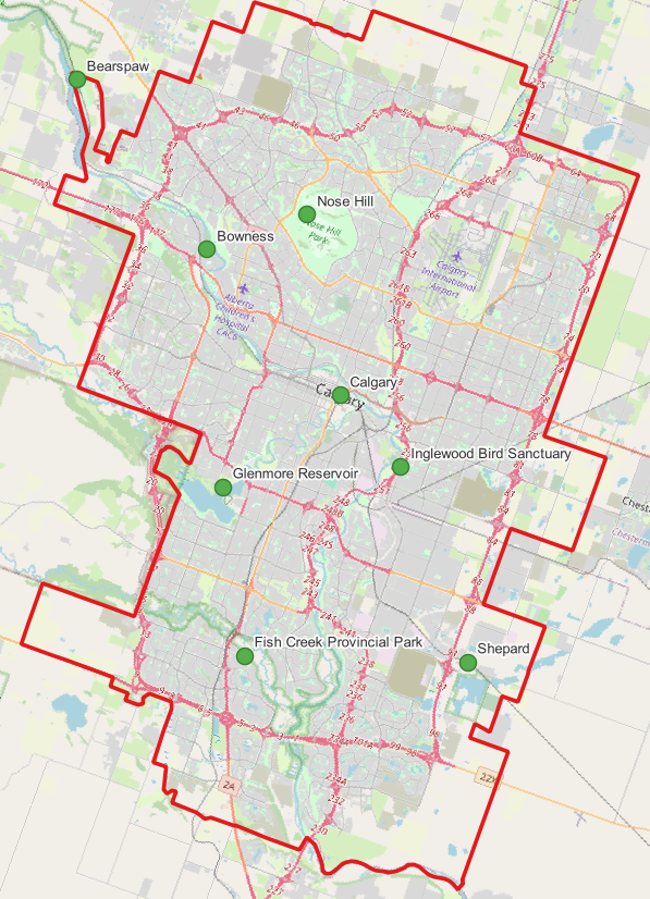
A key requirement was ensuring that place names in English, French, and Indigenous languages were authoritative, consistent, and easy to search. Working with NRCan, MSC integrated a tailored subset of the Canadian Geographical Names Database, Canada’s official national source for standardized geographical names. This allows WeatherCAN to accurately link forecasts and alerts to more than 11,000 localities across the country. These include smaller communities within cities such as Calgary, where alerts now reflect eight distinct neighbourhood sites instead of one city-wide point.
This collaboration demonstrates the benefits of shared standards and authoritative data in Canada’s SDI. It improves everyday public services, strengthens emergency readiness, and respects Canada’s linguistic and cultural diversity, including Indigenous naming traditions.
Regularly engage stakeholders and partners
Engagement is a two-way conversation, which requires active listening and responding to partners and stakeholders. Effective engagement is essential for creating buy-in and shared ownership.
We will strengthen domestic and international collaboration on geospatial modernization through existing and possible new multi-sector in-person and online engagements and partnerships. The goal is to foster the open exchange of ideas and to ensure that a range of voices and viewpoints are heard.
Inspire and develop next generation workforce
Technological change and demand across sectors are changing what geospatial skills are needed. We will raise awareness and facilitate provincial and territorial collaboration to enhance geospatial skills development. That work will address primary, secondary, and post-secondary education, credentialing, recruitment, retention, and inclusion.
CCOG members will also work with our respective human resources departments to modernize hiring and continuous learning. We aspire to build a geo-enabled workforce that includes underrepresented and minority groups and that addresses the gender divide.
Mapping affordability for better policy-making: The Housing and Transportation Cost Index
Household expenditures are often measured through shelter costs alone, but location also shapes how Canadians access work, school, and essential services. The Housing and Transportation (H+T) Cost Index was developed by Statistics Canada and Housing, Infrastructure and Communities Canada. It integrates geospatial data on housing ownership and rental costs, transportation networks and costs by mode, and household incomes. This information provides a spatially focused measure of two major cost-of-living components.
By linking costs to both geography and income, the index highlights trade-offs. For example, lower housing prices farther from urban centres can be offset by higher transportation expenses, while well-connected areas may reduce total costs despite higher housing prices. The index relies on Canada’s SDI to bring standardized datasets across jurisdictions into interactive maps and dashboards that show how affordability varies within and across communities.
Findings also show how affordability shifts over time. In Toronto, the share of income required for a new homeowner rose from 50% in 2004 to 77% in 2014 and nearly 88% in 2024. In Edmonton, the trend moved from 22% to 40%, then eased to 36%. Data also reveal how ownership costs decline for established homeowners, widening the gap with new entrants.
These insights demonstrate how embedding geospatial analysis in Canada’s SDI enables governments to design more effective housing policies, target infrastructure investments, and support evidence-based planning for livable and sustainable communities.
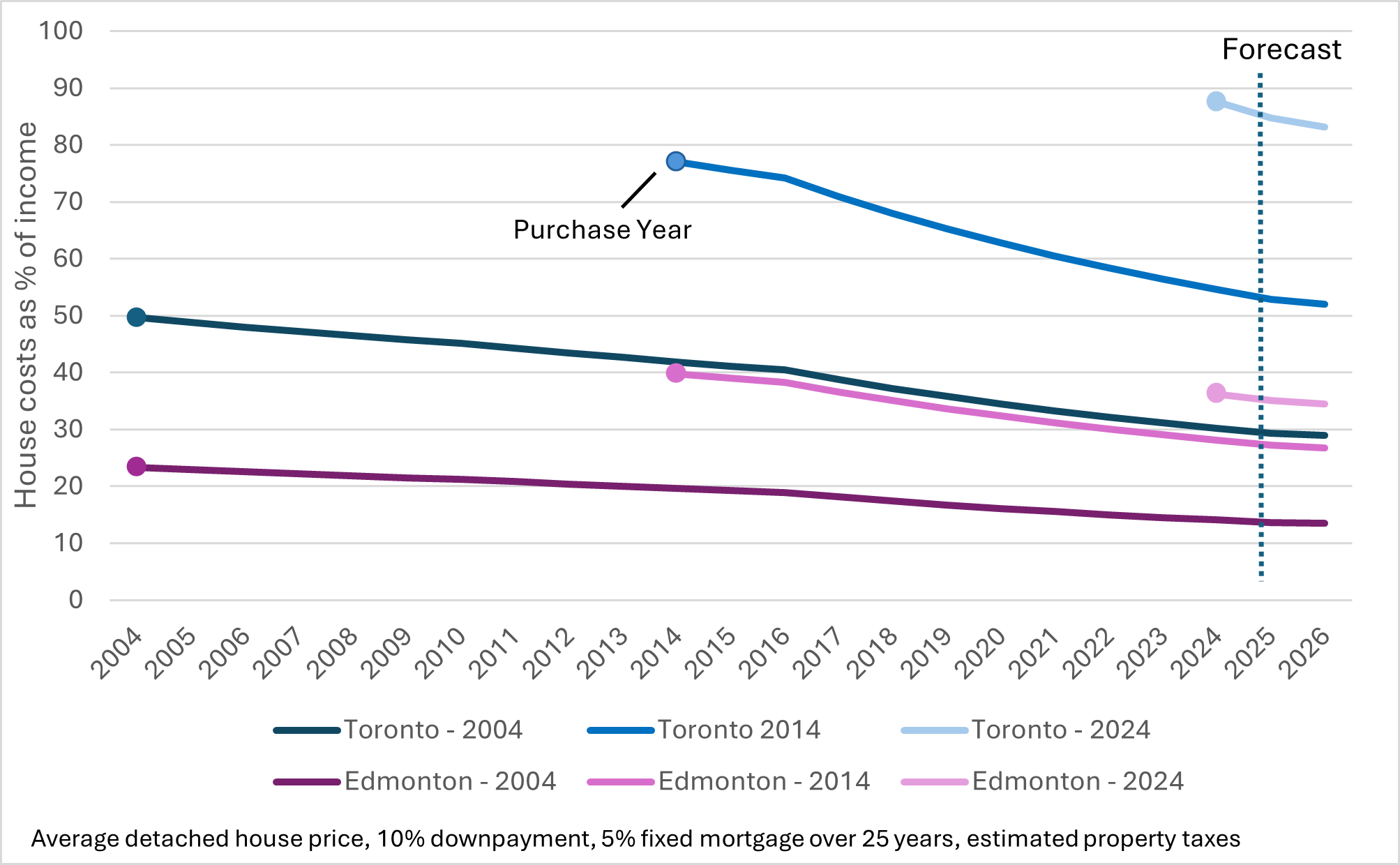
Text version
Graph of house costs as % of income for Edmonton and Toronto for 3 purchase year (2004, 2014 and 2024).
|
Year |
Toronto |
Toronto |
Toronto |
Edmonton |
Edmonton |
Edmonton |
|---|---|---|---|---|---|---|
|
2004 |
50 |
- |
- |
23 |
- |
- |
|
2005 |
49 |
- |
- |
23 |
- |
- |
|
2006 |
48 |
- |
- |
23 |
- |
- |
|
2007 |
47 |
- |
- |
22 |
- |
- |
|
2008 |
46 |
- |
- |
22 |
- |
- |
|
2009 |
46 |
- |
- |
21 |
- |
- |
|
2010 |
45 |
- |
- |
21 |
- |
- |
|
2011 |
44 |
- |
- |
21 |
- |
- |
|
2012 |
43 |
- |
- |
20 |
- |
- |
|
2013 |
43 |
- |
- |
20 |
- |
- |
|
2014 |
42 |
77 |
- |
20 |
40 |
- |
|
2015 |
41 |
76 |
- |
19 |
39 |
- |
|
2016 |
40 |
74 |
- |
19 |
38 |
- |
|
2017 |
39 |
71 |
- |
18 |
37 |
- |
|
2018 |
37 |
68 |
- |
17 |
35 |
- |
|
2019 |
36 |
65 |
- |
17 |
34 |
- |
|
2020 |
34 |
63 |
- |
16 |
32 |
- |
|
2021 |
33 |
61 |
- |
16 |
31 |
- |
|
2022 |
32 |
58 |
- |
15 |
30 |
- |
|
2023 |
31 |
56 |
- |
15 |
29 |
- |
|
2024 |
30 |
55 |
88 |
14 |
28 |
36 |
|
2025 |
29 |
53 |
85 |
14 |
27 |
35 |
|
2026 |
29 |
52 |
83 |
13 |
27 |
34 |
Close capacity gaps in underserved communities
We recognize the distinct obligations to Indigenous communities. We will work with Indigenous organizations in our jurisdictions to understand needs through engagement and to co-develop capacity-building initiatives. Parallel engagement efforts guided by a user-centric perspective will support rural and northern communities with access to tools and training.
These strategic missions define the core pillars of Canada’s geospatial future. They are grounded in partner and stakeholder insights and aligned with global best practices, providing a durable and flexible structure for collaboration.
Our path to implementation
Canada’s competitiveness, security, and quality of public services increasingly depend on how effectively we use geospatial intelligence. In an era where economies are driven by data, governments are expected to proactively assess and respond to complex challenges with speed, precision, and accountability.
Without a coordinated approach, sustained investment, and leadership, Canada risks falling behind its peers. We will miss opportunities to innovate, which weakens our ability to respond to crises, and limits the efficiency and equity of services delivered to Canadians. The cost of inaction will be measured in lost productivity, slower emergency response, ill-equipped communities, higher costs to taxpayers, and diminished sovereignty over the spatial assets we depend upon to literally map Canada’s future.
The Collaborative Geospatial Strategy for Canada addresses these stakes directly. It is not the endpoint, but a first coordinated step towards a more resilient, equitable, and innovative geospatial future.
The strategy invites leadership, collaboration, and creativity across and within governments, Indigenous organizations, academia, civil society, and the private sector. The goal is to move to federated solutions, transparent communications, and integrated data, services, and analytics. This will equip Canada with proactive intelligence to mitigate risks, anticipate and act on future challenges and opportunities. The strategy’s success depends on a collective willingness to modernize infrastructure, empower people, and unlock the full value of geospatial information for all Canadians.
From 2026 to 2031, implementation will be guided by shared priorities and grounded in practical action through the development of phased and flexible implementation plans by CCOG and our members. Implementation will reflect CCOG’s shared purpose and leadership, FPT governments’ roles and responsibilities within their respective jurisdictions, and the federal government’s responsibility to deliver on national-level priorities and champion Canadian interests. In addition, implementation will leverage shared business cases, partner-led initiatives, and lessons from global best practices.
We will share the CCOG action plan publicly and develop indicators to track and communicate our progress towards our shared vision. Importantly, the strategy will remain a living framework. It will evolve in response to new technologies, policy shifts, and societal needs to continue modernizing Canada’s SDI so that Canada is truly Innovative, Intelligent, Integrated, and Inclusive.
Acknowledgements
Developing the Collaborative Geospatial Strategy for Canada was a collective effort that brought together expertise, commitment, and collaboration from across the geospatial community. The Canadian Council on Geomatics appreciates the many individuals and organizations who contributed their time, knowledge, and insight to the strategy.
They include the CCOG Collaborative Geospatial Strategy Task Team, which provided guidance and oversight:
- Melanie Desjardins, Director, NWT Centre for Geomatics, Government of Northwest Territories
- Eiad El-Fateh, Director of Data and Analytics, Housing, Infrastructure and Communities Canada
- Sumit Gera, Senior Director, Canadian Geospatial Data Infrastructure Division, Natural Resources Canada
- Lieutenant-Colonel Eric Godin, Directorate General of Intelligence Policy and Partnerships, Department of National Defence
- Chris Hemmingway, Director, Marine Spatial Data Services and Licensing, Canadian Hydrographic Service
- Julie McKay, Manager, Land Information Infrastructure Secretariat, Service New Brunswick
- Martin Plante, Chef du service du traitement et de la production de la référence géographique du Québec, Ministère des Ressources naturelles et des Forêts