Any successful business requires a sound inventory of its stock, and forestry is no exception. To be successful in the global market, Canadian producers need to control inventory right back to the forest.
Squeezing maximum value from each tree harvested requires not only an understanding of valuable fibre attributes, but also the ability to identify these attributes in the forest and to separate trees for particular end uses. Forest inventories enable companies to plan operations and deploy equipment and personnel to access, harvest and deliver the right raw material to the right mill and markets, at the right time.
Enhanced forest inventory: An exclusive FPInnovations video highlighting the innovative technologies which allow gathering data in a whole new way and more precisely than ever. Duration 2:57
Many forest inventories across the country are more than 20 years old, and were not designed to optimize each link in the forest value chain. Existing tools and methods are simply unable to support today’s needs for accuracy, spatial detail and timely updates.
The Canadian Forest Service (CFS) is working with other federal organizations, FPInnovations, and provincial, industry and academic partners to develop enhanced forest inventory systems that produce information to a level of precision required for value chain optimization. These systems will reduce costs, increase profitability and position the forest sector for long-term economic sustainability—to the benefit of forest-based communities across the country, and thus Canada as a whole.
Ground-based, airborne and satellite remote sensing technologies are being used to measure the characteristics of trees, forest stands, forests and landscapes. Accurate spatial data allow for the identification of raw materials with specific attributes to meet existing and emerging markets, as well as the identification of sustainability features, such as sensitive areas, wildlife habitat and wetlands.
Software tools are being developed for forest managers to work with enhanced inventory data quickly and easily, enabling better-informed decisions related to forest operations, product flow, marketing and sustainability.
LiDAR
One promising technology being used to enhance the quality, accuracy and precision of forest inventory data is LiDAR (light detection and ranging). LiDAR systems measure the time it takes for laser impulses emitted from the instrument to be reflected back to the sensor. The times are used to compute the distance and location of each reflection point in the target of interest. As such, LiDAR can be used to render highly accurate models of forest cover, understory vegetation, and the ground surface.

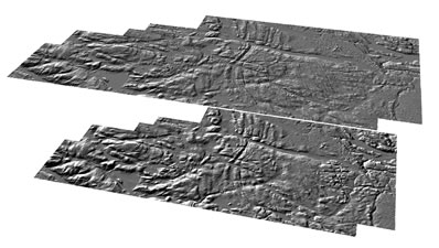
A comparison of a LiDAR derived 2m digital terrain model (bottom) compared to the Ontario Base Map 10m digital terrain model product (top).
An important CFS goal is to develop cost-effective LiDAR methods for surveying large areas. This involves modeling the relationships between data collected by LiDAR systems and a suite of forest inventory attributes that help to determine the quantity and quality of the fibre resource.
Airborne or aerial LiDAR systems are capable of covering vast tracts of forested lands and allow partial characterization of vertical and horizontal structure.
Ground-based or terrestrial LiDAR systems complement aerial systems, capturing the finer geometrical, branching topology and biophysical attributes of the various forest elements. The data collected by both types of systems can be used to generate statistically-based estimates of key inventory variables, including tree height, volume and basal area, and even fibre attributes linked to wood quality.