Ontario’s Shale and Tight Resources

A product of the Energy and Mines Ministers’ Conference
Ontario’s Oil and Gas Resources

- N/A BILLION CUBIC FEET
Technically Recoverable Natural Gas

- N/A MILLION BARRELS
Technically Recoverable Crude Oil

- 0.01 BILLION CUBIC FEET/DAY
Total Natural Gas Production (2013)- 0 BILLION CUBIC FEET/DAY
Shale/Tight Gas Production (2013)
- 0 BILLION CUBIC FEET/DAY

- 0.001 MILLION BARRELS/DAY
Total Crude Oil Production (2013)- 0 MILLION BARRELS/DAY
Tight Oil Production (2013)
- 0 MILLION BARRELS/DAY
Source:
- Resource estimates: not available
- Production estimates: National Energy Board (may not align with provincial data due to differences in methodology)
Geography
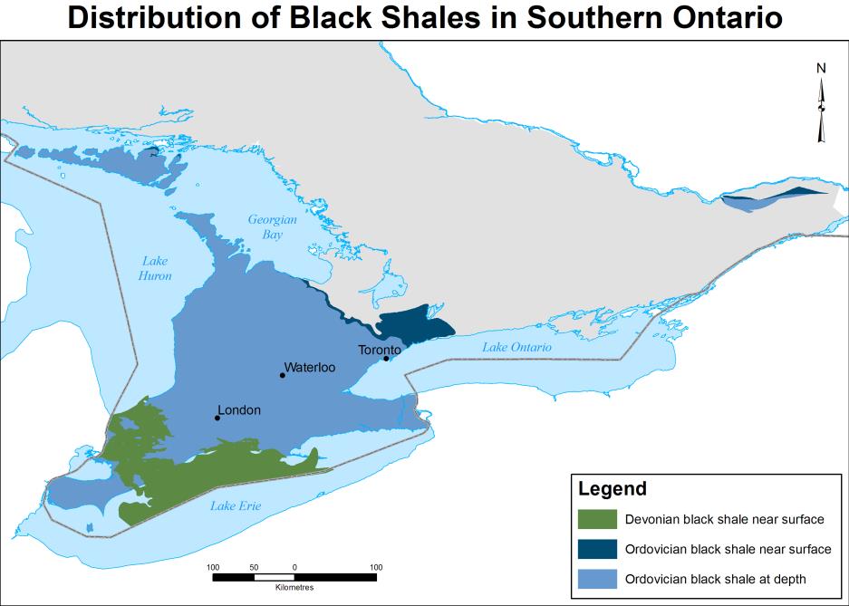
The Upper Ordovician Collingwood and Rouge River black shales extend from their outcrop belt, between Pickering and Collingwood, into the subsurface of southwestern Ontario beneath younger Paleozoic strata. Equivalent units are known in fault blocks in eastern Ontario and in a small area in the Asheweig-Winisk River area of the Hudson Bay Lowlands. Equivalent-age black shales, such as the Mount Pleasant and Utica shales, are widespread across the northeastern United States and into Quebec.
Black shales of the Middle Devonian Marcellus Formation are limited in Ontario to small area in the vicinity of Port Stanley. This unit extends under Lake Erie and is widespread across the northeastern United States,
The Upper Devonian Kettle Point Formation underlies Lake Erie and the Chatham-to-Sarnia area of southwestern Ontario. Equivalent Upper Devonian black shales occur in Michigan (the Antrim Shale), Ohio (the Ohio Shale) and across eastern North America. The Long Rapids Formation, an equivalent black shale in northern Ontario, is found in the southern James Bay Lowlands.

© Queen's Printer for Ontario. Reproduced with permission.
Geology
Ordovician and Devonian aged black, organic-rich shales occur in both southern and far northern Ontario.
The Upper Ordovician Collingwood and Rouge River shales of southern Ontario are considered equivalent to the widespread Mount Pleasant-Utica shales of the northeastern United States. The Collingwood Member (upper Cobourg or Lindsay Formation) is a fissile, organic-rich, very fine-grained limestone. It gradationally overlies (interbedded with) grey, organic-poor limestones of the underlying lower Cobourg (or Lindsay) Formation. The Collingwood Member is up to 10 metres thick, but thins rapidly to the southwest. Total organic content (TOC) of this unit ranges up to 7 percent.
The Collingwood Member is overlain with apparent disconformity by the non-calcareous, organic-rich, brown to black shale of the Rouge River Member (lower Blue Mountain Formation). The Rouge River Member has up to 3 percent TOC, and is up to 50 metres thick. This unit is found at depths of up to 1 kilometre in southwestern Ontario. The Rouge River Member is gradationally overlain by grey shales of the upper Blue Mountain Formation.
Equivalent units of both the Collingwood and Rouge River members, the Eastview Member (Lindsay Formation) and Billings Formation, respectively, occur in small fault blocks in eastern Ontario. Black, organic-rich, fine-grained limestones of the Boas River Formation, considered equivalent to the Collingwood Member, occur in a small area in the Hudson Bay Lowlands.
Black shales of the Middle Devonian Marcellus Formation occur in the shallow subsurface in a small area on the north shore of Lake Erie and under Lake Erie. This represents the erosional edge of the Marcellus Formation that extends over a large area in the northeastern United States.
The Upper Devonian Kettle Point Formation consists mainly of brown to black, organic-rich shale with up to 15 percent TOC. It is equivalent to widespread black shale deposits known across eastern North America. The Kettle Point Formation disconformably overlies grey shales and limestones of the Middle Devonian Hamilton Group. It mainly subcrops beneath Quaternary (glacial) sediments at depths averaging about 35 metres, but which can be up to 150 metres. Near Sarnia it is overlain by grey shales and sandstones of the Port Lambton Group. The Kettle Point Formation is up to 105 metres thick, but averages only about 30 metres thick.
Upper Devonian black shales of the Long Rapids Formation, equivalent to the Kettle Point Formation, occur in the Moose River Basin of the James Bay Lowlands.
Exploration and Production
Shale gas or shale oil are not being extracted anywhere in Ontario, and there are no requests to explore for shale gas or shale oil.
Regulation
Petroleum and natural gas exploration and development in Ontario is currently regulated under the Oil, Gas and Salt Resources Act, Regulation 245/97, and the Provincial Operating Standards (PDF, 1.8 MB). The disposition of provincially-owned oil and natural gas rights is managed under Part IV of the Mining Act (Regulation 263/02). The Ontario Ministry of Natural Resources and Forestry is the lead government ministry regulating petroleum and natural gas exploration and development in the province.
The Ministry of Natural Resources and Forestry has stated that it would not approve any application to use high-volume hydraulic fracturing unless the regulations were strengthened to protect the public and the environment.
Any enhancements to Ontario’s rules to properly regulate shale development must first be brought forward for appropriate consultation with stakeholders, Aboriginal communities and the public.
Public Research
The Ministry of Northern Development and Mines – Ontario Geological Survey has been conducting a field study of bedrock in southern Ontario to assess the bedrock’s potential to host gas and to characterize the gases. The purpose of the study is to better understand the natural connection between Ontario’s shale rock formations and possible implications for groundwater quality in Southern Ontario.
Energy and Mines Ministers’ Conference
Page details
- Date modified:
