A product of the Energy and Mines Ministers’ Conference
Nova Scotia’s Oil and Gas Resources

- N/A TRILLION CUBIC FEET
Technically Recoverable Natural Gas

- N/A MILLION BARRELS
Technically Recoverable Crude Oil

- 0.2 BILLION CUBIC FEET/DAY
Total Natural Gas Production (2013)- 0 BILLION CUBIC FEET/DAY
Shale/Tight Gas Production (2013)
- 0 BILLION CUBIC FEET/DAY

- 0.002 MILLION BARRELS/DAY
Total Crude Oil Production (2013)- 0 MILLION BARRELS/DAY
Tight Oil Production (2013)
- 0 MILLION BARRELS/DAY
Source:
- Resource estimates: not available
- Production estimates: National Energy Board (may not align with provincial data due to differences in methodology)
Geography and Geology
The Maritimes basin formed during the late Paleozoic (300–350 million years ago). Stresses caused by the movement of the plates carrying the North American and African continents caused some areas to sink and form basins. Sediments that were deposited in this regional basin cover most of New Brunswick, all of Prince Edward Island, parts of Nova Scotia and onshore Newfoundland. The Maritime basin also covers the sea floor in between the four Atlantic provinces.

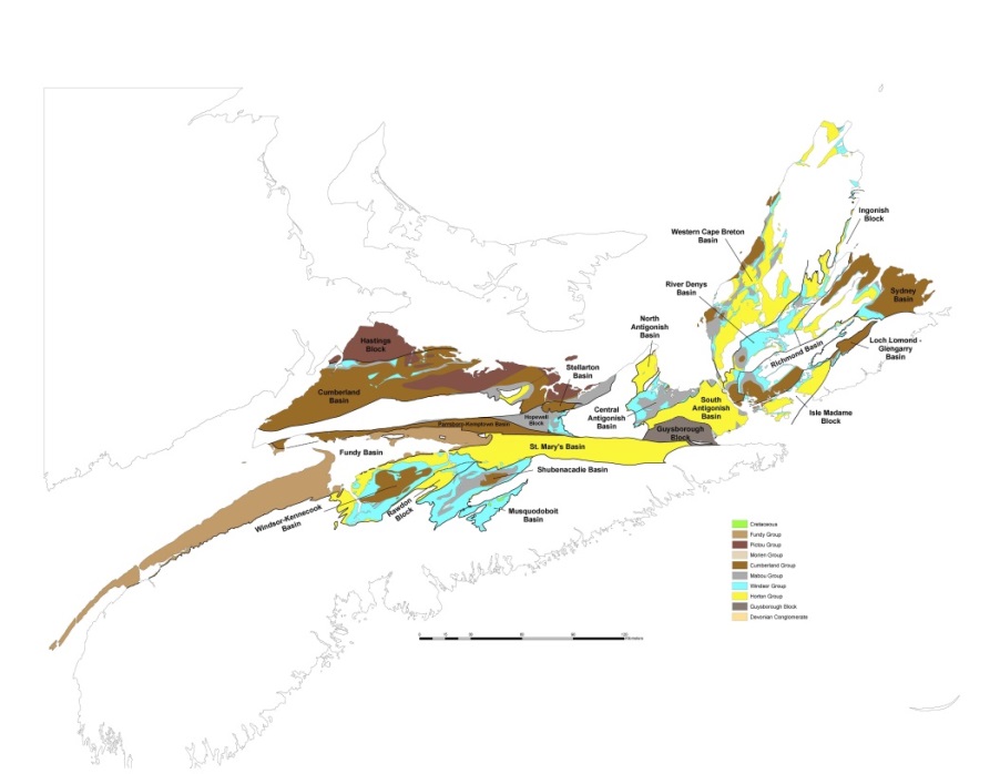
Figure 1: Basins and Group Geology
Source: Nova Scotia Department of Natural Resources
Text version
Figure 1: Basins and Group Geology
Map showing the geological groups of Nova Scotia’s onshore oil and gas basins.
Most of the northern half of Nova Scotia is covered by sedimentary rock. The basins make up roughly a third of Nova Scotia’s surface area.
The Horton group in Nova Scotia hosts organic rich shales, which are the primary source for oil and gas in Nova Scotia’s onshore basins. The Windsor group, a sequence of carbonates and evaporates deposited in the Late Visean (330 million years ago) is also seen as a source for natural gas and oil in the province.
The thick organic shales of the Horton group have been drilled and cored in the Windsor-Kennetcook basin of Nova Scotia. Sections of black shale more than 500 metres thick have been found there. The Horton Bluff shales and the sands and siltstones associated with them are seen as a primary petroleum source rock. It is also the primary target for shale gas in the province of Nova Scotia. Ryder-Scott, a highly regarded petroleum engineering firm, provided an estimate of a potential of 69 trillion cubic feet (Tcf) of gas locked in the currently explored portion of the Windsor-Kennetcook basin for the exploration company who collected the data in the region. It has yet to be successfully unlocked.
The Cumberland basin is the part of the Nova Scotia basin closest to New Brunswick and their production in Horton equivalent formations at Stoney Creek and MacCully. No well in this basin has yet penetrated the Windsor group, so it is uncertain whether the Horton group is even present in the Cumberland part of the Maritime basin. The potential has yet to be disproved and could be significant. This basin is separated from the rest of the Nova Scotian basins by faults and the Cobequid Highlands.
The Stellarton basin is a smaller basin that holds many of the productive coal measures in the province and is centred around the towns of Stellarton and New Glasgow. The Department of Natural Resources produced an estimate back in 1990 of oil shale potential in the Stellarton area of 168 million stock tank barrels (MMSTB) of oil. Coal bed methane is associated with coals in the Pictou group in Stellarton, Springhill and Sydney areas. A variety of resource estimates from private industry and the Geological Survey of Canada have shown a potential for 2.5 Tcf of gas in the various coals of Nova Scotia.
Antigonish county holds the Antigonish Sedimentary Basin. Cape Breton is mostly sedimentary rock, with the Cape Breton Highlands being the most prominent exception.
Nova Scotia’s offshore natural gas is processed at the gas plant in Goldboro in Guysborough county. A transmission lateral runs from there, north to Point Tupper. The mainline heads west through to New Brunswick and down to markets in New England. Another lateral goes southwest from Pictou county through Colchester and Halifax counties. A proposed gas storage facility at Alton would result in an extension of the gas distribution network deep into Hants county.
The Nova Scotia Department of Energy is funding an internal Petroleum Atlas project designed to collect and rationalize geological data relating to oil and gas in the province. The project has an ultimate goal of providing another set of estimates for resource potential independent of those gathered by industry. The first version of the Petroleum Atlas is scheduled to come out in 2017.
Exploration and Production
The Government of Nova Scotia announced plans to introduce legislation to prohibit high-volume hydraulic fracturing for onshore shale gas on September 3, 2014. They introduced that legislation as amendments to the Petroleum Resources Act on September 30, 2014 putting that moratorium into effect.
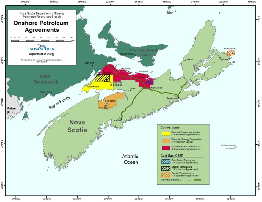
Nova Scotia currently has six companies exploring for either coal gas or conventional oil and gas on almost 875,000 hectares of land. There are a total of nine agreements, which may be broken down as follows: five exploration agreements, one conventional oil and gas production lease, one coal gas exploration agreement and two coal gas production agreements.

Figure 2: Onshore Petroleum Rights Map
Source: Nova Scotia Department of Energy
Text version
Figure 2: Onshore Petroleum Rights Map
Map showing the locations of Nova Scotia’s onshore petroleum exploration and production agreements for conventional resources and coalbed methane.
East Coast Energy is attempting to dewater the Foord Coal seam in Stellarton, where they have drilled a successful horizontal well in search of coal bed methane (coal gas). The rest of the industry in the province has been dormant for the last three years.
As of 2014, there have been no commercial discoveries and no royalties have been collected in the onshore activity, but the province is on the edge of this potential opportunity.
Regulation
All activities fall under the provincial Petroleum Resources Act. The Act is administered under the supervision and management of the Nova Scotia Department of Energy and gives the Minister the authority to create subsequent regulations. Under the Act, there are several regulations, including the Petroleum Resources Regulations, Onshore Petroleum Geophysical Exploration Regulations and the Onshore Petroleum Drilling Regulations. Some activities that fall within such regulations are tenure, geophysical and well permits and approvals.
Petroleum authorities and approvals include the following:
- Application for Coal Gas Exploration Agreement
- Application for a Coal Gas Production Agreement
- Application for a Conventional Exploration Agreement
- Application for a Conventional Production Lease
- Authority to Abandon a Well
- Authority to Alter the Condition of a Well
- Authority to Drill a Well
- Authority to Explore – Geophysical Activities
- Authority to Terminate a Well
- Transfer of Interest Approval
The Nova Scotia Department of Energy works closely with other departments and agencies for approvals to petroleum exploration and activities. These include Nova Scotia Department of Environment (NSE), Department of Natural Resources (DNR), Transportation and Infrastructural Renewal (TIR), Labour and Advanced Education (LAE), Office of Aboriginal Affairs (OAA), among others.
For pipeline and underground storage activities, the following legislation applies: Underground Hydrocarbons Storage Act, Underground Hydrocarbons Storage Regulations; Pipeline Act, with Pipeline Regulations, and Gas Plant Regulations.
