A product of the Energy and Mines Ministers’ Conference
Nunavut’s Oil and Gas Resources

- 181.43 TRILLION CUBIC FEET
Technically Recoverable Natural Gas

- 18.25 BILLION BARRELS
Technically Recoverable Crude Oil

- 0 BILLION CUBIC FEET/DAY
Total Natural Gas Production (2013)- 0 BILLION CUBIC FEET/DAY
Shale/Tight Gas Production (2013)
- 0 BILLION CUBIC FEET/DAY

- 0 MILLION BARRELS/DAY
Total Crude Oil Production (2013)- 0 MILLION BARRELS/DAY
Tight Oil Production (2013)
- 0 MILLION BARRELS/DAY
Source:
- Resource estimates: Meyerhoff, 1982; Nassichuk, 1983; Procter et al, 1984; Procter, 1989; Chen et al, 2000; Bent et al., 2013
- Production estimates: National Energy Board (may not align with territorial data due to differences in methodology)
Geography and Geology
Generally, the petroleum source rocks, the shales, are preserved in four of the geological provinces among the nine recognized in Nunavut (Figure 1). They are Hudson Bay Platform, Arctic Platform, Innuitian Orogen (Sverdrup Basin) and Baffin Shelf, in which the Paleozoic, Mesozoic and Cenozoic shales are exposed by numerous outcrops and penetrated by limited drillings.
Paleozoic rocks cover approximately one third of Nunavut. Strata lying to the west and northwest of Fury and Hecla Strait are part of the Arctic Platform that continues northward onto Ellesmere Island, whereas those to the southeast underlie the Foxe Basin and represent the northern continuation of the Hudson Bay Platform. In general, the Upper Ordovician and Upper Devonian strata yield oil shales in the Hudson Bay Platform; the Upper Ordovician, Silurian and Lower Devonian shales, and shales of the clastic wedge are the common petroleum source rocks in the sedimentary sequence of Arctic Platform.
In Sverdrup Basin, the shales are preserved in the Upper Paleozoic, Mesozoic and Lower Cenozoic sedimentary sequence, which include Carboniferous and Permian bituminous shales, Triassic marine oil prone shale, Mesozoic non-marine gas prone shale, Upper Cretaceous and Paleocene marine shales (natural gas with some oil).
Along the Baffin Shelf, the Cretaceous and Paleocene shales are considered as petroleum source rocks.
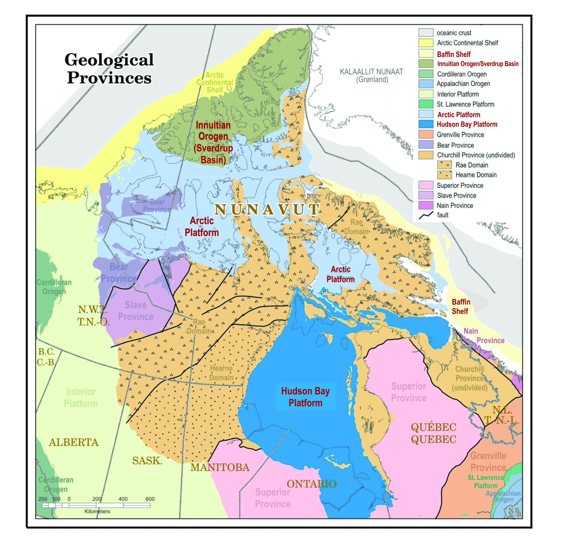
Figure 1: Geological Provinces in Nunavut. The red-coloured fonts highlight the four provinces with petroleum source rocks
Source: Modified from de Kemp, E.A., Gilbert, C. and James D.T. (2006), Geological Survey of Canada, Map D1860A
Text version
Figure 1: Geological Provinces in Nunavut. The red-coloured fonts highlight the four provinces with petroleum source rocks
Map of Nunavut’s geological provinces which highlights the four provinces with petroleum-source rocks: the Baffin Shelf, the Innuitian Orogen (Sverdrup Basin), the Arctic Platform and the Hudson Bay Platform.
Exploration and Production
Sverdrup Basin
Most exploration activities in Nunavut took place in the Sverdrup Basin during the 1970s and 1980s; 140 out of the 180 wells in Nunavut were drilled in this basin and the adjacent Arctic Platform. In this area every second well flowed and tested was positive for petroleum, and one out of five found oil. A significant petroleum discovery was made on or near every major island in the western Sverdrup Basin (Figure 2). Industry made 20 significant oil and natural gas discoveries and one commercial oil discovery in the Sverdrup Basin. On eastern Melville Island 2 billion barrels of oil equivalent in the form of dry gas was discovered; six kilometres from the west shore of Lougheed Island, thought to be a billion-barrel oil field was discovered; between 1985 and 1996, 3 million barrels of oil were produced at Bent Horn field on Cameron Island. Bent Horn supplied the light oil that was crudely burned in the generators at Resolute Bay, as well as at the Polaris Zinc Mine.The Sverdrup basin potentially contains another 4.2 billion barrels of conventional oil.
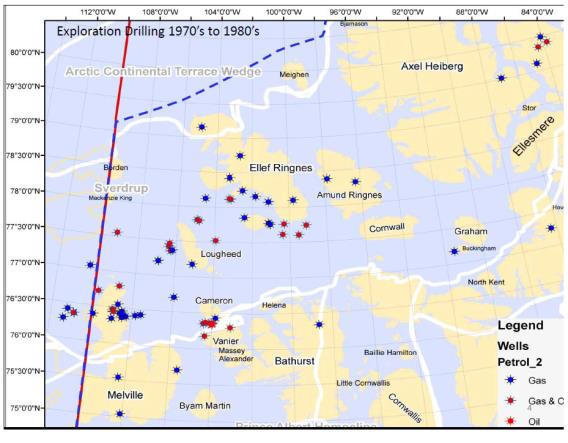
Figure 2: Exploration drillings in Sverdrup Basin during the 1970s and 1980s
Source: Frampton, P. and Prosh, E. (2012), Nunavut’s petroleum exploration and production history, status and prospects, presentation at oil and gas session, Northern Lights Convention Trade Show (2012)
Text version
Figure 2: Exploration drillings in Sverdrup Basin during the 1970s and 1980s
Map of the locations in the Sverdrup basin where exploratory drilling took in the 1970’s and 1980’s.
Baffin Shelf
Along the Baffin Shelf, five wells were drilled in the Davis Strait and discovered a giant natural gas field, Hekja, 76 km east of Frobisher Bay. Hekja remains the only discovery along Baffin Shelf, and the best estimation of Hekja’s discovered resources is 4 trillion cubic feet of natural gas and condensates. Hekja is located in the Saglek Basin, along a passive continental shelf margin, and the reservoir discovery lies within a structural trap. Another area of interest along the Bafin Shelf is the natural oil seeps occurrences in Scott inlet. The hydrocarbons leak profusely in the water, and giant oil slicks have been measured to be up to 250 km2 in surface area (Oakley et al., 2012). These seeps are the testimony of an active petroleum system in the region, and have been identified as a potential exploitable hydrocarbon discovery.
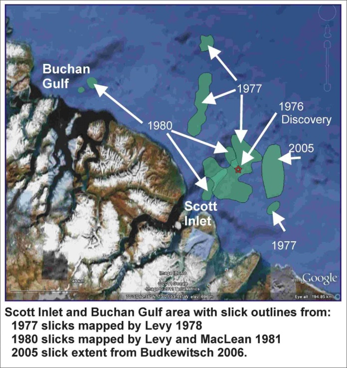
Figure 3: Map showing Scott Inlet area oil slicks locations
Text version
Figure 3: Map showing Scott Inlet area oil slicks locations
Map showing Scott Inlet area oil slicks locations.
Hudson Bay Platform
The Hudson Bay Basin is one of the largest Paleozoic basins in Canada (Sandford, 1987). Only nine wells were drilled with a few seismic lines in the central portion of Hudson Bay. No important discovery was made, and exploration efforts by industry were abandoned in 1980 due to poor results from the wells. Estimating the petroleum potential of the Hudson Bay Platform Basin is currently part of the Geological Survey of Canada’s ongoing research.
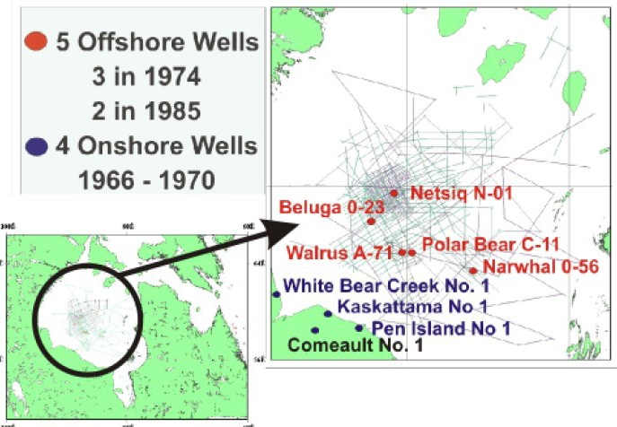
Figure 4: Historical seismic coverage and well locations in the Hudson Bay Basin
Source: Lavois et al. 2010
Text version
Figure 4: Historical seismic coverage and well locations in the Hudson Bay Basin
Historical seismic coverage and well locations in the Hudson Bay Basin.
Arctic Platform
An area adjacent to the Sverdrup Basin, called the Parry Islands Fold Belt Basin, in the Cameron Island area, shows oil potential estimated to be between 2 and 10 Billion barrels of oil, and between 14 and 51 TCF of natural gas. The Lancaster Sound Basin in the Arctic Platform also has high petroleum potential, but was never drilled. The petroleum system in the basin is of Cretaceous or younger in age. Latest studies of the Lancaster Sound (Brent et al., 2013) suggest a mean value for the petroleum potential of 4.5 billion barrels of oil, and 13.0 TCF of natural gas and condensates.
Regulation
The Government of Canada is the primary regulator of all petroleum exploration and production in Nunavut. The National Energy Board and Indigenous and Northern Affairs Canada are the two federal bodies that administer petroleum activities through the following acts:
Petroleum activities in the Nunavut Settlement Area are also subject to the requirements of the Nunavut Land Claim Agreement.
At this time, there are no shale/tight oil- and gas-specific regulations for Nunavut.
Regulation of Exploration
Any surveys and exploration activities require operating licences from the National Energy Board. Consultation and environmental assessments are key steps for authorization processes for any activities. At this time, there are no shale-specific policies with regard to exploration.
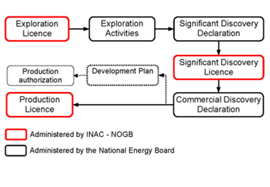
Figure 5: Schematic of the regulatory system in Nunavut on frontier land (crown land and offshore)
Source: INAC
Text version
Figure 5: Schematic of the regulatory system in Nunavut on frontier land (crown land and offshore)
Schematic of the regulatory system in Nunavut on frontier land (crown land and offshore)
Regulation of Production
Similar to exploration activities, production activities require authorization from the National Energy Board. At the same time, tenure of any licenses is managed by Indigenous and Northern Affairs Canada. At this time, there are no shale-specific policies with regard to production.
Public Research
Significant research on petroleum resources including shale has recently been conducted through the Geo-mapping for Energy and Minerals (GEM) program led by the Geological Survey of Canada and Canada-Nunavut Geoscience Office.
