
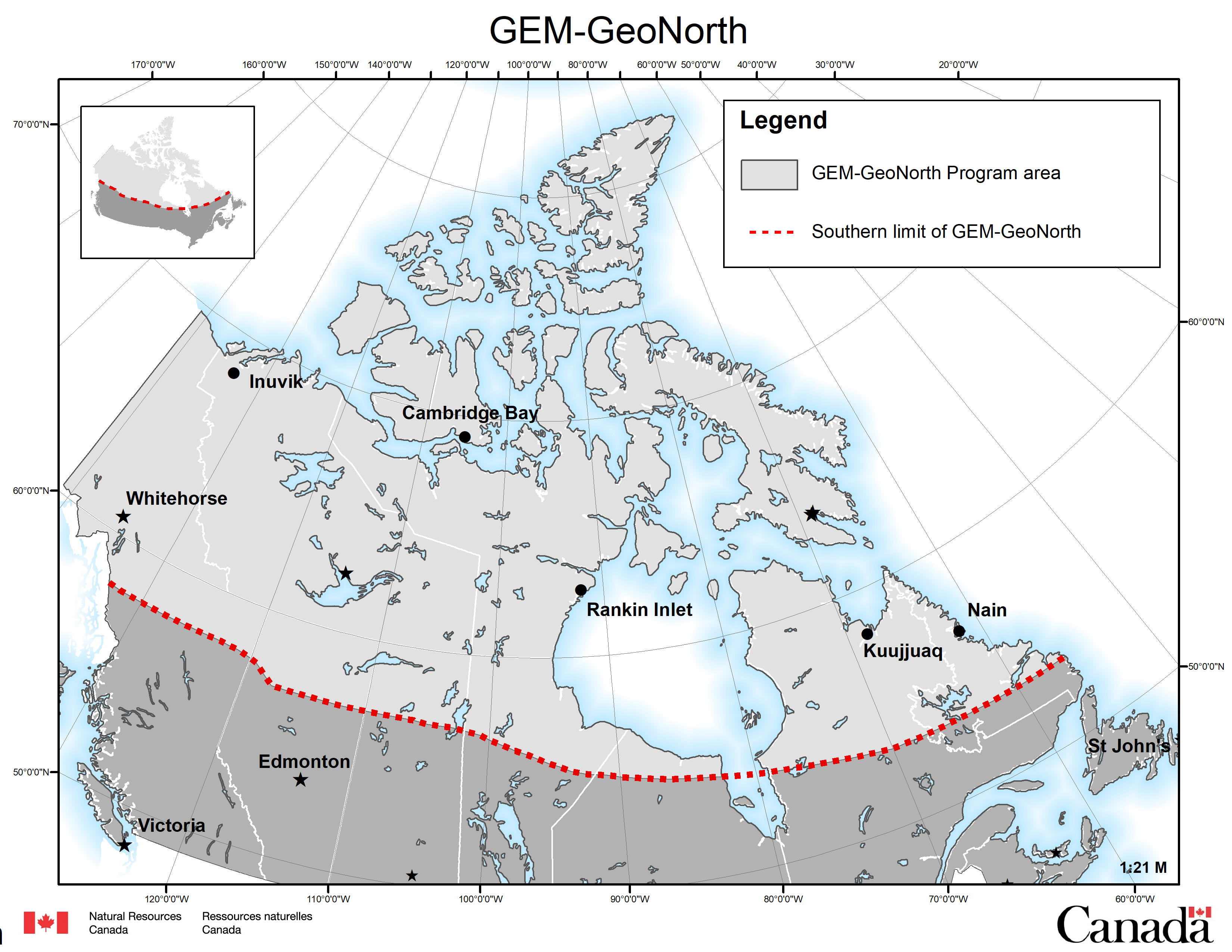
Map of GEM-GeoNorth Program area
Text version
In 2020, Year 1, GEM-GeoNorth began our geoscience research with a call for proposals for foundational science activities.
Foundational activities are science activities that do not have a fieldwork component. These include, but are not limited to, desktop studies, reanalysis of existing samples with new techniques and analysis for newly prioritized critical minerals.
In the following years, we held a second and third competitive call for proposals for geoscience research activities in the North. These proposals were not limited to desktop studies and could include fieldwork, pending approval from territories and provinces, and Indigenous government and organizations.
The following is our list of Geological Survey of Canada science activities from the GEM-GeoNorth Program.
FOUNDATIONAL ACTIVITIES
Definitions
Permafrost: Permafrost is soil or rock that remains frozen from one year to the next and is an important component of the northern Canadian landscape. It occurs when the ground remains at or below a temperature of 0 °C for a minimum period of two years.
Talik: A layer or body of unfrozen ground in a permafrost area.
Analysis of mudstones in Northwest Territories
Title: Geochemical and isotopic analysis of Cretaceous organic rich mudstones in the Northwest Territories: assessing their metal and rare earth elements (REEs) prospectivity, toxicity, combustion potential, and the role of mass wasting in perpetuating slump-induced environmental loading
We were interested in studying metal-rich mudstones in archival samples taken from the Smoking Hills formation and other rock layers from the Cretaceous period. These rock layers are exposed along the Mackenzie corridor. Our goal was to examine these rocks for their potential to contain valuable metals and rare earth elements (REEs), as well as to understand any potential risks they may pose to the environment and human health.
Initial observations from the Smoking Hills area showed that the water draining from these mudstones contains extremely high levels of toxic metals, such as cadmium, which is over 7000 times higher than the safe drinking water guidelines. The Smoking Hills experiences spontaneous combustion, where the rocks catch fire on their own due to the hydrocarbons present. We analyzed samples with the focus on studying the combustion potential of these samples, looking at how easily they caught fire and how much energy they released when burned. We also explored the potential for these rocks to contain valuable metals and REEs that could be important for various applications.
We analyzed around 200 core samples from petroleum wells to study their chemical composition and organic carbon isotopes as well as 20 of the original field samples for sulfur and oxygen isotopes. The high cadmium levels in the Smoking Hills formation are particularly intriguing and unusual. These levels may have been part of a global geological pattern in Cretaceous rocks. We collaborated with an expert to study cadmium isotopes and see if they could serve as an environmental tracer. The Smoking Hills formation has some unique sulfur-based minerals, and we were not sure if these were due to original conditions, weathering or other geological processes. To better understand this, we employed techniques to analyze the mineral composition of the samples. This study provided good baseline data on the characterization of these mudstones.
Grays Bay permafrost geoscience
Title: Permafrost Geoscience for Infrastructure and Resource Development in the Grays Bay—Yellowknife Corridor
This activity was focused on current and future conditions of permafrost in relation to surface sediments, natural processes shaping the landscape, and the warming climate along the Grays Bay—Yellowknife transportation corridor in the Northwest Territories. We aimed to map important features of the permafrost terrain, gather existing data about permafrost and surface characteristics, and create detailed models showing ground ice potential in key development zones.
This study generated valuable insights for planning, managing and mitigating the effects of thawing permafrost on the development of sustainable transportation routes and mining facilities in the region. The study area covered a critical region for economic and resource development in the Northwest Territories and Nunavut. While we had a good understanding of the surface geology and permafrost in the southern part of the corridor within discontinuous permafrost terrain, our knowledge was limited for the central and northern sections. In these areas, the stability of the land is influenced by deposits like till (rock and soil debris), glaciofluvial sediments (carried by glacial meltwater) and marine deposits. We combined existing information with new data obtained through advanced image analysis and by leveraging expertise effectively. During 2021–2022, we mapped out landforms connected to permafrost and analyzed how they related to the surrounding geological conditions using updated images covering a 10-kilometre section of the corridor and adjacent high-potential development areas.
Our ultimate objective was to understand how these landforms and sediments formed, allowing us to predict how the landscape might change over time. Unfortunately, comprehensive data about permafrost conditions in this region were not readily accessible or compiled at the time. To address this, we partnered with the Canada-Nunavut Geoscience Office (CNGO) and the Northwest Territories Geological Survey (NTGS) to align research priorities and consolidated and organized data, making them available through Open Files and databases. Partnering with the CNGO and NTGS helped Indigenous communities and organizations and the industry have access to the geological data and knowledge generated by this study, which also contributed to making informed decisions about managing natural resources and land use in Canada’s North.
Keewatin glacial dynamics
Title: Synthesis of the glacial dynamics of the Laurentide Ice Sheet in the west-central Keewatin
This research activity focused on the west-central part of the Keewatin region in the Northwest Territories and mainland Nunavut. This area is covered by materials left behind by glaciers, which makes it difficult to study the underlying bedrock geology and explore for minerals. At the onset of this activity, there was no framework in place for decisions related to land ventures, such as infrastructure development, mineral exploration and permafrost changes.
Understanding the history of the Laurentide Ice Sheet (LIS), which in the past covered a large part of North America, is challenging due to the lack of detailed maps, field data and vague timelines. Some limited work had suggested that there were multiple times when glaciers covered the area, leaving behind different types of landscapes. The centres from which the glaciers spread had also shifted over time. The goal of this activity was to fill in the missing geological information for the west-central Keewatin region and to produce maps that would help understand how glaciers moved and shaped the landscape in this region.
The project involved gathering existing data about the surface geology, using advanced satellite images, and creating detailed digital maps of the landforms. It followed established procedures for processing images, creating maps and organizing the geoscience data. Glacial features layers from computer-generated maps (CGMs) were compiled to help create a reference base for new surficial mapping. The focus was on creating comprehensive maps and interpretations of the glacial landforms and landscapes using the foundation platform that was built. Fieldwork was conducted to fill in any gaps and ensure remote mapping accuracy.
Modelling in Northern Canada
Title: Numerical methods to enhance modelling capabilities for Northern Canadian environments
Enhancing our understanding of how groundwater flows and how it interacts with surface water in the region north of the discontinuous permafrost zone is crucial for managing water efficiently and sustainably. The discontinuous permafrost zone is an area with permanently frozen ground interspersed with unfrozen ground. Our current knowledge about the water systems in this region is limited due to difficulties in accessing data and the environment. By creating comprehensive models that combined the behavior of groundwater and surface water in Northern Canada, better insights were gained into how water behaves in this economically important area. This knowledge will help assess the cumulative effects and understand the consequences of a changing climate in discontinuous permafrost regions.
To do this effectively, it was necessary to continually refine how the models are built and represented, incorporating the unique characteristics of northern hydrology. One way to achieve this was by developing a model for a specific area within the region where extensive data was available. This allowed for the confirmation of the accuracy of modeling methods. To simulate groundwater-surface water flow in the North, a model was created and combined groundwater, surface water and climate data for the Carcajou River watershed. This watershed, covering an area of 7,800 square kilometres in the Central Mackenzie Valley, is a diverse landscape with mountains and plains. The ground in this area is partially frozen, with varying amounts of ice content underneath. Existing data on climate, landcover and surface water were used to build the initial version of the model. Information about the geological and hydrogeological features, as well as the permafrost in the region, filled in the details of the subsurface parameters. The model was fine-tuned using long-term surface water gauging data to ensure it accurately represented real-world conditions.
This model was used to determine the interactions of surface and subsurface water within a larger regional framework north of the discontinuous permafrost zone. The insights gained from this project have wide-ranging implications for development and sustainability efforts in discontinuous permafrost across Canada’s North, from specific sites to the larger regional context.
Nunavut and Manitoba till samples
Title: Reanalysis of Nunavut and Manitoba trans-boundary regional till samples for the creation of a GEM standard geochemical database: drivers for innovative mineral exploration techniques in complex glacial landscapes
In the Kivalliq region of Northern Manitoba, there is insufficient knowledge about the composition of surface materials due to a mix of factors like thick layers of sediment left by glaciers, complex patterns of ice movement in the past and a lack of comprehensive studies that span different areas. This lack of information makes mineral exploration in the region difficult.
The study covered an area of 450,000 square kilometers, which is expected to see new infrastructure developments and is believed to contain valuable resources, such as metals and minerals needed for green technologies. The most extensive collection of materials resulted from the regional surficial survey conducted in the 1970s by the Geological Survey of Canada (GSC). However, the methods used to study samples at that time were not as advanced as those used now, and the samples were only analyzed for a limited number of elements. Additionally, more recent surveys conducted by the GSC were difficult to compare with the older data because they used different techniques and scales of measurement.
For this activity, a thorough analysis of the fine-grained material (smaller than 63 micrometres) found in 1,000 stored soil samples was undertaken. These samples had been collected from various locations, with around 750 samples from the Kivalliq region. All these samples were comprehensively analyzed for a wide range of elements to help identify potential deposits of valuable resources such as gold, diamonds, critical minerals and rare earth elements within the region. A standardized dataset was created to house all the geochemical information and was accessible to everyone. The plan was to combine the geochemical information from the soil samples with detailed information about how glaciers had moved over time. This information included factors like the flow direction of the ice, the distance it traveled, where it came from, and the characteristics of the rock and terrain it traveled over. By bringing these datasets together, high-resolution maps were created that highlighted areas with potential for valuable resources.
Scheelite mineralization
Title: Potential for scheelite mineralization in the Western Canada Sedimentary Basin
The goal of this research project was to explore the potential for valuable minerals in an area of the southwestern Northwest Territories. Specifically, we wanted to investigate the possibility of finding scheelite, an important mineral used in producing tungsten. This study also aimed to complete outstanding work from the GEM-2 Southern Mackenzie Surficial activity, which took place from 2017 to 2020. The GEM-2 project identified promising signs of valuable mineral deposits beneath the thick layer of ice and rock between Hay River and Fort Providence. These deposits included minerals like copper, zinc and lead as well as higher levels of scheelite.
Till samples from the Northwest Territories Geological Survey (NTGS) that contained heavy minerals, including scheelite, as well as samples from the Horn Plateau area that were originally collected to search for kimberlite indicator minerals (KIMs) were re-analyzed. We re-examined all of these samples to check for base metal sulfide minerals, scheelite, rare earth minerals and other critical minerals.
The extracted mineral grains were carefully examined using a scanning electron microscope (SEM) at Memorial University of Newfoundland (MUN) to create detailed images of their surfaces. Additionally, these grains underwent a sophisticated analysis to determine their composition. This helped us understand the fundamental chemical makeup of the grains. At the MUN, the grains were examined for trace elements. Information gathered provided useful insights into the potential for valuable minerals in this region.
Slave Craton resource potential
Title: Slave Craton: Integrated surface (crust) — lithosphere studies for resource potential and infrastructure development
This research activity aimed to gather new data and knowledge on the geological history of key new regions within the Slave craton. A craton is an old stable part of the Earth’s lithosphere. By utilizing modern techniques that measured temperature changes over time (thermochronology), as well as studying both the upper crust and inner mantle layers of the Earth in these targeted regions, we hoped to create a more complete picture of their geological makeup and how they had evolved over time.
Understanding how these cratonic regions came into existence and how they changed over time was crucial for understanding the valuable resources they may contain. While we had a good understanding of the central Slave craton, our knowledge about the surrounding areas to the west and north was limited. The outcomes of this research enhanced our geological understanding of the Yellowknife–Grays Bay Road Corridor’s resource potential, as well as contributed to our knowledge of how changing Arctic coastlines are influenced by geological processes, such as uplift. More specifically, this research helped us better understand the history of the surface, the layers of rock beneath it, and the deeper layers of the Earth. This improved understanding led to more accurate models of the geological events that shaped these regions, as well as the connection between these events and the minerals that might be found there, like diamonds, gold and rare earth metals. These findings could potentially help predict where certain types of rocks — like kimberlites that may contain diamonds — might be found on the surface, or how much material may have eroded away from potential metal deposits.
Automated glacial mapping
Title: Automated mapping for a new glacial map of Northern Canada
This project aimed to test the automated mapping capabilities of NRCan’s High Resolution Digital Elevation Model (HRDEM) to understand the dynamics of ancient ice streams. Ice streams are pathways of fast-moving ice within glaciers that leave distinctive landforms behind. By analyzing these landforms with cutting-edge geospatial techniques and machine learning, we can gain insights into how these ice streams behaved in the past. Canada has a complex glacial history from the Pleistocene epoch, marked by periods of extensive glaciation. Understanding how these glaciers shaped the landscape and its resources is a unique challenge in Canada due to the vastness of the country’s glaciated regions.
This project followed a multi-step process to create a detailed map of glacial features in Northern Canada. Our primary focus was on landforms left behind by glaciers, and we validated our interpretations with actual field data, such as mapped landforms and striae, which are scratches in bedrock caused by glacial movement. We started by testing our methods on South Baffin Island in collaboration with experts from the Canada-Nunavut Geoscience Office.
Since the modern landscape has been greatly shaped by the Last Glacial Maximum and subsequent ice melting, a focus on ice stream beds, eskers (ridges of sediment deposited by glaciers), and other landforms left behind as the ice retreated, was important in gaining a better understanding of how the Laurentide Ice Sheet decayed so rapidly in Canada. To map these features, we used a technique called Curvature-based Relief Separation, which allowed us to create a detailed database of the landforms characteristics, like width, length, height and shape. The orientation and shape of these landforms could tell us about the direction and speed of the ancient ice flows. We then used advanced machine learning methods to analyze this data and find patterns that could help us quantify these relationships.
Techniques developed through this project played a crucial role in producing a new glacial map for Northern Canada. An updated map provided insights into the past and has practical applications for the future such as for conducting mineral exploration, assisting in mapping groundwater resources, and guiding development in northern regions, especially as the climate warming continues.
Gossan analysis for critical mineral
Title: Mineralogical and geochemical investigations of gossans as vectors to critical mineral deposits in the Canadian Arctic
This activity studied barren and fertile gossans by using advanced techniques to better understand these rock formations in the Eastern Canadian Arctic. Gossans are surface deposits formed from the weathering and oxidation of minerals in the host bedrock and are often associated with valuable minerals and metals.
The future success of Canada’s mining industry depended on access to a secure supply of critical minerals. This study employed innovative approaches that could improve the potential for new discoveries of critical minerals in Canada’s North. Specifically, we were interested in understanding the geochemistry of gossans (both base and noble metals) and how they might indicate the presence of valuable minerals in the bedrock on Melville Peninsula and Eastern Baffin Island.
Our research built on previous studies conducted in Northern Canada, which supported our scientific hypothesis: Could the physical characteristics, rock layers, mineral composition and chemical properties of gossans provide insights into the mineral potential of the host bedrock they sat on? This activity consisted of two main phases, utilizing our team’s expertise in remote sensing, mapping, mineralogy, geochemistry and ore deposits:
Part 1: We tested our hypothesis using existing mineralogical and geochemical data from gossans, stream sediments and host bedrock in the designated study area. We also verified parts of a previously proposed model.
Part 2: We applied the results from our model to the gossans in the study area identified by remote predictive mapping. The first step was to assess the level of geological knowledge associated with each gossan identified by this mapping technique. With this knowledge, we then validated our scientific hypothesis using a subset of gossans for which we had field observations, samples and data.
This novel approach had never been applied to gossans identified through remote predictive mapping before. It served as a pilot project to be expanded upon in future studies of gossans mapped across Canada’s North.
Hopedale Lake sediment geochemistry
Title: Lake-sediment geochemistry reanalysis of the Hopedale/Nain Region, and other foundational work
This project aimed to expand a detailed map of the chemical composition of lake sediments from the core zone region to the Labrador coast. This map was expected to reveal information about the types of rocks beneath the surface, which are hidden by thick layers of glacial material. The region east of the Core Zone has high potential for rare earth elements (REEs) and other critical metals (for example, deposits in Voisey’s Bay and Strange Lake). Archived sediment samples from lakes in this area were accessed and were reanalyzed using modern techniques to better understand their elemental makeup. One of the goals was to improve knowledge about the types of rocks in the area. We were particularly interested in areas with nickel, copper, platinum group elements, silver, critical minerals like lithium and REEs, as well as potential gold deposits formed in different geological settings.
For this activity, more than 4,500 sediment samples from lakes across the 60,000 square kilometre study area were analyzed or reanalyzed. Bedrock samples were also examined for dating and isotopic data alongside the lake sediment geochemical data. These analyses gave us a broader understanding of the potential mineral resources across different geological settings in this region, especially elements that were previously not analyzed. Prepared archived sediment samples were sent to a commercial laboratory for detailed geochemical testing.
The results of these analyses were made publicly available as a Geological Survey of Canada Open File publication. The new information garnered from this study expanded the geochemical map of the Labrador Trough and core zone, creating a seamless lake sediment geochemical map to the Labrador coast. This work also contributed to the understanding of the geological history of the North Atlantic Craton, a region where it is difficult to map the bedrock due to the extensive glacial cover.
Roche Bay greenstone belt
Title: Roche Bay greenstone belt geology and mineral potential (Phase 1: fiscal year 2021–2022)
This research activity was focused on detailed mapping and thorough analysis of the Roche Bay belt to gain a deeper understanding of its geological structure, rock composition and potential for valuable minerals. The Roche Bay belt is a geological formation on the eastern side of Melville Peninsula, in Nunavut, that is known to potentially contain important minerals like precious metals and base metals.
In the 1960s, regional airborne surveys identified iron ore in the area. However, the region has received very little or no attention for exploration for gold and base metals. The GEM-1 Melville Peninsula project revealed the presence of significant anomalies related to gold, platinum group elements, base metals and heavy minerals, suggesting a high likelihood of finding these valuable materials in the vicinity of the Roche Bay belt. The abundant ultramafic rocks in the Roche Bay belt, located a short distance from Sanirajak and accessible by snowmobile, could also be studied for their potential as carving stones. Ultramafic rocks contain low levels of silica and high levels of magnesium and iron.
This research activity involved publishing legacy uranium-lead geochronological data obtained from the GEM-1 Melville Peninsula project via a GSC Open File report. By using advanced satellite imagery with high-resolution details and combining it with archival and field data collected in 2009, we aimed to create four preliminary geological maps of the southern half of the Roche Bay belt. These maps were produced at a scale of 1:50,000 and provided valuable insights into the bedrock structure of the area. Additionally, we aimed to carry out a detailed analysis (petrographic analysis) of rock samples collected during the GEM-1 project, to describe and classify them. The data from the 2009 campaign already indicated the presence of gold, chromite, gahnite and rubies, among other valuable indicators. The availability of high-resolution satellite images, a resource that was not accessible during the GEM-1 project, greatly enhanced our understanding of both recent geological history and ancient bedrock formations.
Boothia terrane extent
Title: Delimiting the extent of Boothia terrane crust: the need for designing alternative mineral exploration strategies in Canada’s North
Mineral exploration techniques that have proven effective for identifying mineral deposits in the Rae Craton may not be suitable for certain areas on the Boothia Peninsula-Somerset Island, in Nunavut. A craton is an old stable part of the Earth’s lithosphere. Current approaches need to be re-evaluated considering recent findings from GEM-2, which significantly enhanced our understanding of the geological makeup and history of the Northern Canadian Shield.
The distinct type of crust in the Boothia-Somerset region is not found in the Rae Craton. This crust is characterized by specific rock types that formed around 2.51 to 2.56 billion years ago, followed by sediment deposits around 2.5 billion years ago, and later intrusion of magma around 2.48 to 2.49 billion years ago. These new findings suggested that the Boothia-Somerset region might contain a unique fault-bounded rock sequence known as a terrane that is different from the surrounding areas. Terranes contain distinctive geological histories. This terrane might have attached itself to the western edge of the Rae Craton at some point in the past. It is possible that the Boothia terrane was part of a much larger ribbon terrain that stretched 1,600 kilometres across north-central Canada, possibly connecting to similar terranes in the North China and Yangtze cratons.
To confirm this hypothesis, this activity studied legacy samples collected during the GEM Frontiers’ Transect expedition in 2012. We conducted thin section and petrology (the study of rocks) examinations, as well as uranium-lead analysis to determine the ages of zircon crystals. These studies helped distinguish between original rock ages and subsequent metamorphic events, providing crucial information about the geological history of the region. The goal was to establish accurate ages for the various geological events that had shaped the region and to understand whether the unique crust found in Boothia-Somerset extended southwest toward Northern Saskatchewan.
The results of this research have helped to refine our understanding of the geological evolution of Northern Canada and potentially impact the mineral exploration strategies along the northern edge of Laurentia, the North American Craton.
Gillam-Kivalliq GICs study
Title: Gillam-Kivalliq geomatically induced currents study
Problems in electrical systems, particularly along major power lines, due to unusual electric currents called geomagnetically induced currents (GICs) can occur. GICs occur in regions where Earth’s magnetic field is disrupted. This study combined existing magnetic and geological data to create a model. This model helped us calculate the potential strength of GICs during strong magnetic disturbances in the planned Gillam-Kivalliq power line corridor. This type of model is called a synthetic Earth conductivity model. This problem is particularly concerning for power lines in the Arctic’s high latitudes, which is worsened by regional conductivity structures in the Earth’s crust.
Previous research suggested the presence of a significant conductive feature beneath the planned Gillam-Kivalliq corridor. This conductive feature had been interpreted as an extension of North America’s largest conductor, the North American Central Plains (NACP). However, we did not know to what extent this conductor potentially contributed to a GIC effect along the power transmission corridor.
Our team compiled geological information along the Gillam-Kivalliq hydro-fiber corridor, from the Earth’s surface to deeper layers underground. We also gathered data from electromagnetic measurements near the corridor, with consideration for the NACP conductor. This activity developed a regional resistivity model for the corridor. We then used it to generate synthetic responses to measure the electrical resistivity of the subsurface. We assessed different methods to accurately predict an unusual electric field linked to geomagnetic storms.
Using a computer model, we incorporated this unusual electric field into a model of the Gillam-Kivalliq hydro transmission line. This helped us determine the GIC that could occur during geomagnetic disturbances in the new power line. We further developed this GIC modeling process to handle the varying electric fields indicated by the electrical resistivity of the subsurface measurements. Additionally, in collaboration with Manitoba Hydro, we expanded the Manitoba power system model to include the Gillam-Kivalliq line. This helped them in determining how well they could model the GIC expected in new infrastructure corridors during geomagnetic disturbances. Results from this study could be confirmed by future data collection along the corridor in order to validate this innovative, data-driven predictive approach to solving this GIC issue.
Hudson architecture and metallogeny
Title: GEM-GeoNorth Western Hudson Bay architecture and metallogeny study
This activity was focused on the Gillam-Kivalliq hydro-fibre link priority corridor in Nunavut and Manitoba. This area contains mineral systems, typically found along structural boundaries of large rock formations. These boundaries act like highways that minerals traveled along as they were being formed. We were interested in studying how these formations developed over time, their physical characteristics and how they relate to the presence of gold.
Recent GEM research in the Kivalliq region had led to a radical re-evaluation of the underlying structure of the Trans-Hudson mountain range of the Rae and Hearne cratons in the area between Meadowbank and Meliadine. This new perspective suggested significant changes in the way we understood the composition and arrangement of both the Earth’s lithosphere (the rigid outer layer) and the crust (the outermost layer) in this region. The Rankin Inlet belt, where the Meliadine mine is located, was believed to be above a significant detachment in the Earth’s crust. The mineral-rich Pyke break was thought to branch off from the newly identified Raptor shear zone. This Raptor shear zone was associated with the major geological boundary known as the Rae-Hearne lithosphere boundary. This boundary may hold information about the Earth’s crustal structure in the region.
This foundational activity recompiled and analyzed data from the study area, along with testing new geophysical and geoscience models of the Earth’s crust and lithosphere. This work could pave the way for future collaborative research efforts in Nunavut. Insights gained from studying this prominent mining area were anticipated to be applicable to nearby regions within Nunavut and the Northwest Territories. This research could improve mineral exploration endeavours and could lead to indirect advantages in the exploration of uranium, rare earth elements, and relatively shallow gold deposits. The creation of an updated map of the Rankin Inlet area would also play a crucial role in the planning of land use decisions by the Rankin Inlet community.
Hudson glacial records
Title: Refining the glacial record in the Western Hudson Bay region, Nunavut and Manitoba: building on GEM legacy datasets
A large part of the land in the Western Hudson Bay region was once covered by a massive sheet of ice called the Laurentide Ice Sheet (LIS). The central part of the LIS contains a variety of landforms shaped by glaciers. This area is important for understanding the history of the ancient ice sheet due to its large size and the presence of the Keewatin Dome, a significant geological feature that influenced how sea levels changed in the past.
A comprehensive database of glacial landforms and features in the Kivalliq region of Nunavut was recently put together. These unparalleled datasets, together with related features identified in Northern Manitoba, gave us the opportunity to reconstruct the history of ice movements and changes in the landscape. By thoroughly analyzing and combining these datasets, we could piece together a detailed picture of how ice flowed and how the ice divide shifted. This knowledge allowed us to understand the patterns of glacial movement, the features of the land shaped by these forces, and map the entire post-glacial marine limit between Churchill and the Arctic Ocean. The research focused on three main sub-activities:
- Figuring out how the ice flowed and moved across the land by studying its effects on the landscape
- Understanding how the land changed over time, including erosion rates and the materials on the surface
- Using data about changes in sea levels and elevation to predict where certain types of deposits might be found
This research could refine the accuracy of global ice-sheet reconstructions using models that account for how the Earth’s crust responded to the melting of ice sheets (glacio-isostatic adjustment models). These models are important for estimating how sea levels have changed in regions like Hudson Bay. Additionally, this research could also help with planning for infrastructure development, like roads and buildings, and predict where valuable minerals might be found.
Northern mapping by Northerners
Title: Northern mapping by Northerners — new tools for a new approach
The proposal aimed to explore the use of existing mobile applications or packages of applications for geological mapping. The focus was on finding applications that could meet the requirements of citizen science efforts in the North. For example, we were interested in applications that could measure the orientation of rock layers (strike and dip), collect observations, display a plain language image glossary, link the phone’s GPS to existing geological maps, and allow users to upload their own observations, photos and more. Key requirements of the chosen platform(s) were supposed to be free or affordable, easy for users to navigate, and compatible with Android and/or iPhone devices. The plan was to assess these applications to see if they were suitable as well as explore the possibility of enhancing their geological capabilities by discussing potential modifications with their original developers to make them better suited for northern geoscience purposes.
The outcomes of the initial phase resulted in enhanced future interactions and consultations with a sample "toolbox". This toolbox served as a practical starting point for conversations with Northerners about how they envisioned citizen science working for their communities. During that foundational year, users populated the toolkit with existing data from the Kimmirut area, in Nunavut, where recent geological data from the Geological Survey of Canada and Canada-Nunavut Geoscience Office were used to create a "walking tour" geology map for non-specialists. That map highlighted features like rock formations and where Inuit prospecting led to the discovery of gem-quality sapphire deposits. Once that test dataset was integrated into the application, it served as the first digital version of that map, which was no longer in print.
In subsequent years, in collaboration with Indigenous organizations, we will aim to develop a resource that could be downloaded and used as a virtual geology guidebook.
Quaternary stratigraphic framework
Title: Western Hudson Bay — quaternary stratigraphic framework
The project aimed to enhance geological knowledge of the Manitoba Hudson Bay Lowlands (HBL), a complex region to study in Northern Canada. This area holds great potential for mineral exploration, but several obstacles are in the way. The rocks most likely to contain minerals are buried under layers of glacial sediment, making them hard to access and study. Additionally, only sparse baseline geological information exists for this region, which has limited infrastructure, making exploration for mineral potential difficult.
The goals of the activity included gathering baseline geological data and advancing knowledge about glacial sediments movements across the Manitoba HBL. To do that, we planned to analyze and interpret various types of data, including information about the composition of the Earth’s surface layers (such as rock types, minerals and chemical makeup) and their characteristics (like texture, color, grain size and compactness). There was also information available about specific layers that were not formed by glaciers, such as ancient DNA and very old radiocarbon ages. We were interested in studying indicator minerals from samples to be collected in summer 2021. Those analyses helped us better understand the prospect of minerals in the study area.
In addition to using traditional methods of study, we planned to incorporate advanced machine learning techniques. To accomplish that, we needed to gather and analyze large amounts of data across the whole 145,000 square kilometres of the Manitoba HBL. By combining those two approaches, we hope to develop a stronger framework of the rock and soil layers in the area to determine how different rock layers formed over time and how they might have been influenced by other geological events. The results have helped us identify potential new minerals prospects and improve exploration success in the region.
Talik mapping underneath Arctic lakes
Title: Mapping open taliks underneath Arctic lakes —Towards conceptual models of subpermafrost groundwater—surface water connectivity to inform decisions regarding mining development facilities
Taliks impact mining projects near lakes. Impacts include the migration of contaminants and changing water levels in those lakes, which can ultimately shorten the lifespan of a mine. Even in regions with permafrost, taliks can create connections between the groundwater beneath the frozen surface and the lakes above. This is particularly important information for mines located close to lakes or taliks, as they typically use nearby water bodies for waste disposal. To improve our understanding of the impact of taliks on water and avoid potential negative economic impacts, this one-year research activity studied the interactions between permafrost and groundwater.
We planned to develop and apply a method to map the locations of taliks in the Kivalliq and Kitikmeot subregions. To achieve this, we estimated lake depths using advanced geographic data (e.g., ArcticDEM data) and validated the findings using optical imagery classification and existing bathymetric information. We also analyzed existing data to further verify the ArcticDEM talik mapping and assess the properties of the rock beneath the ground.
We were interested in exploring the possibility of using hydrochemistry data to identify lakes with or without taliks. We mapped four key aspects: bedrock hydraulic properties, water flow conditions in lakes with open taliks, lakes with hydrochemical taliks and talik-water connections in permafrost regions undergoing change. Ultimately, this research aimed to provide a solid foundation for sustainable mining practices by shedding light on the complex interactions between taliks, groundwater and surface water in regions with permafrost.
Cretaceous–Cenozoic faults and fluids
Title: Cretaceous to Cenozoic evolution of faults, fluids and landscape in the northern Canadian Cordillera
The project aimed to minimize risks associated with the exploration of valuable metals found in the Earth’s upper crust. These metals were deposited via gradual buildup in western Canada’s mountainous area, known as the Canadian Cordillera, during the Cretaceous to Eocene period. Many of these deposits were formed through hydrothermal processes, which involved hot fluids moving through the Earth’s crust along fractures called faults.
Research under GEM-2 and the Targeted Geoscience Initiative indicated that there were periods of intense faulting and movement in this region in the Late Cretaceous to Cenozoic era. Previous researchers hypothesized that these faults acted like pathways for large-scale hydrothermal systems, picking up valuable metals along the way, then concentrating them in specific areas. This research project focused on examining rocks from this era to understand how these processes happened.
For this activity, we used archival samples from the Yukon Geological Survey and GSC collections for thermochronological analysis, favouring samples that likely contained both zircon and apatite. The samples underwent a process of mineral separation and dating, utilizing three distinct thermochronological techniques. We also planned to study existing calcite samples from GEM-2, along with rock types that could be used in this dating method for future detailed sampling. By modelling the newly acquired thermochronological data, we intended to construct temperature-time histories of the upper crustal rocks within this geological region.
This work formed the foundation for a broader, more extensive study in the future, focused on creating the first comprehensive thermochronological datasets spanning the entire northern Canadian Cordillera mountain region. By combining fault/fluid dating with low-temperature thermochronology, we determined key areas for further investigation.
Intermontane superterrane
Title: Development of the western Intermontane superterrane and its overlap assemblages
In the mountainous region of British Columbia, known as the Northern Cordillera, there are challenges in understanding the relationships between different rock layers, how they assembled, the 3D arrangement of land masses, and the history of faults and uplifts, all of which are critical for exploring mineral resources. The rocks span from Proterozoic to Mesozoic, and they have been assembled through various tectonic processes over time, including the gradual assembly of distinct land masses, the deposition of sediments and volcanic materials, and the movement of rocks along strike-slip faults. Because of this complex history, there is a mix of areas with potential for valuable minerals and areas that lack those resources. To better understand the geological makeup of this region, our project was divided into three main parts:
- Isotopic characterization — We planned to study the characteristics of rocks formed by volcanic activity (i.e., magmatic rocks). They can provide valuable information about how different geological areas formed, help distinguish between these areas and shed light on the origins of valuable mineral deposits. Additionally, these rocks contribute to the materials found in sedimentary layers, which are important for understanding the Earth’s history and how it has changed over time.
- Paleozoic terrane framework — We aimed to improve our understanding of the ancient rocks that formed the basement (i.e., foundation) of specific regions. We used various techniques to analyze existing samples to learn about the history and characteristics of these rocks. This information was crucial for creating accurate maps and predicting where valuable minerals might be located.
- Thermochronology — We were interested in how certain rocks had been affected by heat and pressure deep within the Earth. These rocks had been pushed to the surface due to the movement of faults and other geological features. We planned to use specialized techniques to investigate the history of these rocks, specifically focusing on the timing of their exposure to high temperatures.
Overall, this research helped us better understand the geological history and framework of the Northern Cordillera and the processes that had shaped it. This knowledge is important for identifying areas with potential mineral resources, which could have economic significance for mining and exploration efforts.
Mesozoic stratigraphy and chronology
Title: Mesozoic stratigraphy of the Northern Cordillera —Improving chronology and high-resolution temporal correlation for new geoscience knowledge on mineralization in western Canada
To enhance our knowledge of mineral formations in the Northern Cordillera region, we needed a better grasp of when these deposits were formed. This involves establishing precise timeframes relative to a global timeline.
The deposits of the Northern Cordillera developed on foreign pieces of terrane that later became attached to the edge of the North American continent during the Mesozoic era, spanning from the Triassic to the Cretaceous periods. Terranes are fault-bounded rock sequences with a distinctive geologic history. Pinpointing the exact timing of these geological and metal-producing events has been challenging due to the limitations of past methods of determining rock layers and radioactive dating. To overcome this, we planned to re-examine archival rock samples from documented areas in British Columbia. The sample rocks included layers of volcanic ash and important fossils used for dating purposes. By linking these samples to the global timescale, we could establish a more reliable timeline of tectonic events and mineral formation in the Northern Cordillera. Our focus was on specific periods within the Mesozoic era that were most relevant to understanding how these mineral deposits formed in the Cordillera region.
Starting with the oldest, deepest layers from the Late Triassic to Early Jurassic period, the formation of copper deposits, gold-rich porphyry deposits (i.e., gold deposits related to volcanic activity) and vanadium deposits in sedimentary rocks were accurately dated. The next group of samples from the Middle Jurassic period was characterized due to massive sulfide deposits and sedimentary exhalative (Sedex) deposits which resulted in zinc-lead deposits. Lastly, the Cretaceous period marked the development of skarn deposits which contained metal ore. Skarn is a rock that has been altered by hot chemically active fluids.
The new correlations we established were used to create more accurate age models. These models have been added to the GSC evolving database of rock layer sequences, using a tool called the TimeScale Creator. This study provided an enhanced understanding of the development of the western edge of the North American continent and the valuable mineral deposits found there.
Neoproterozoic–Silurian evolution
Title: Neoproterozoic to Silurian evolution of the northwest Laurentian margin — Evaluating existing evidence
This activity aimed to address gaps in our understanding of the geological development of the northwest margin of the North American continent. This area’s evolution from the Neoproterozoic to the Silurian period is crucial for accurately predicting the presence of valuable mineral deposits. A key aspect of this study was examining how the land in this region split apart over time, a process known as continental rifting. This fundamental geological process had a direct impact on the potential for valuable minerals to form. By investigating the early history of the region’s geological structures, including the faults that could have allowed fluids to flow, we aimed to create more accurate models for mineral deposits. This, in turn, is expected to improve the success of exploration efforts. Our project involved several specific tasks to achieve these goals:
- Thermomechanical modelling — We used computer simulations to better understand the geological formations in the area, including the Wernecke, Belt-Purcell, Pinguicula, Muskwa, Mackenzie Mountains and Windermere successions.
- Structural analysis — We investigated an event from the Neoproterozoic period, when the land experienced a contraction that resulted in large, elongated folds spanning tens to hundreds of kilometres. These folds formed between periods of extension (when the land stretched apart).
- Refining stratigraphy — We created a more accurate timeline of the rock layers present in the Mackenzie Mountains during the Ediacaran-Cambrian period.
- Improving fossil dating — We re-examined existing collections of Cambrian trilobite fossils from the Mackenzie Mountains. By using advanced dating techniques, we refined the timeline of these fossils.
- Enhancing exploration — We focused on refining the ages of Sedex deposits, which are valuable mineral deposits. The Ordovician-Silurian strata found in the Road River group within the Selwyn Basin (e.g., Howard’s Pass) contain important Sedex deposits.
This knowledge has far-reaching implications, supporting future assessments of the region’s stratigraphy, tectonics, evolution and potential for valuable mineral deposits, and contributing to longer-term GEM-GeoNorth goals. Our work also contributed to the ongoing effort to expand the Atlas of the Western Canadian Sedimentary Basin.
Thermochemical architecture
Title: Thermochemical architecture of the northwestern Canadian Lithosphere — Two billion years of tectonic evolution and its impact on mineral system development
This project aimed to study and understand the structure and development of the Earth’s crust and mantle beneath the central Mackenzie and Richardson Mountains. The insights gained from this research will contribute to our knowledge of valuable minerals, such as base metals and rare earth elements, which are crucial for the advancement of green technologies.
To achieve this, we used advanced geophysical methods to examine the geological features that control the formation of mineral deposits. This was an important step in the process as there had been a lack of comprehensive information about this region prior to this project. The area we focused on contained a variety of mineral deposits, including sulfide deposits formed during the Proterozoic period, and other types of deposits rich in iron, copper, zinc and lead that formed during different times in Earth’s history. By analyzing the large-scale, geophysical data available and studying the known mineral deposits in the region, we hoped to uncover connections between the distribution of these minerals on the surface and the underlying structure of the Earth’s mantle.
This study involved amalgamating all the existing geophysical data to create a detailed 3D model of both the Earth’s mantle and crust in the northern Canadian Cordillera and Mackenzie Corridor. We used the LitMod software suite, which allowed us to simultaneously analyze various types of information, such as gravity measurements, surface heat flow and wave data, and information gathered from electromagnetic measurements. Further studies could involve a field campaign, using new geophysical instruments to gather more data and fill in the gaps identified during this project.
Yukon-Tanana tectonic evolution
Title: Tectonic evolution of the eastern Yukon-Tanana terrane and related Laurentian margin in the Canadian Cordillera
In the Late Devonian period, there was a significant geological event known as the Yukon-Tanana terrane (YTT) rifting in the Canadian Cordillera mountain range. This event, along with the formation of valuable mineral deposits, remains poorly understood. In the southeastern Yukon region, valuable deposits of precious metals, base metals and critical minerals are found in rocks that were shaped by the Devonian rifting and later, mountain-building processes (i.e., orogeny). By studying the rocks that existed before the rifting event and understanding their position in relation to Laurentia during the Devonian period, scientists can gain insights into the geological structure and history of the Laurentian landmass.
We were interested in studying the poorly understood eastern YTT, where it meets the Laurentian landmass. Comparing the eastern YTT to the western YTT helped identify major internal structures and provided important context for understanding the region’s early geological history, the interaction zone with Laurentia, and its origins.
Approximately 8,000 rock samples from the GEM / National Geoscience Mapping Program YTT collections in Vancouver (collected between 2000 and 2018) were examined, along with samples from earlier pre-GEM collections. These samples were analyzed for their physical properties, and the resulting data was shared with other related research efforts and interested parties through the Geological Data Flow project. Follow-up work involved analyzing rock samples from the western YTT collections to build upon GEM-2 research. As we studied rocks from the Laurentian landmass related to the YTT, it enhanced our understanding of both settings’ geological processes. This comprehensive framework could be beneficial for predicting where valuable minerals might be found and guiding future geological surveys.
Detecting permafrost changes with remote sensing
Title: Thematic pan-North study — Baseline quantification of permafrost surface changes with synthetic aperture radar interferometry (INSAR) to support land-use planning
The purpose of this study was to use advanced remote sensing techniques to understand how permafrost changes over time. This information could help inform environmental assessments and land use planning. Most of the future transportation and mining infrastructures planned for Northern Canada will be built on permafrost; however, they are at risk of becoming unstable because climate change is impacting the ice content in the upper layers of ground in permafrost regions. This is a concern because the frozen ground could thaw and lead to ground instability, which could impact new developments.
In this activity, we used a technology called INSAR to monitor changes in the permafrost. This technology uses satellites to take pictures of the ground and can detect even small changes over time. We wanted to compare two different places: Tuktoyaktuk Coastal Plain near Tuktoyaktuk, where we already had data on surface displacement and buried ground ice, and Point Upland near the Ekati diamond mine, an area we suspected had gradual permafrost surface movement and buried glacial ice.
We hypothesized that the landforms in both places would behave similarly if they shared similar characteristics underground, which may support the theory of buried glacial ice in Point Upland. To test this, we used images taken by the European Space Agency’s Sentinel-1 satellite, which can take pictures of the same areas every 12 days — often enough to see surface changes on the ground. At the site near Tuktoyaktuk, we already knew the ground was seasonally changing. We compared these movements with what we found in Point Upland to see if the landforms in both places had related behaviour. Overall, this study helped us better understand how permafrost changed in different areas in Canada, and how it might affect the land and infrastructures.
Assessment of geospatial dataset
Title: Assessment of approaches and cost associated with data correction of the High Resolution Digital Elevation Model (HRDEM) product for Northern Canada
This activity evaluated the Canada Centre for Mapping and Earth Observation’s (CCMEO) HRDEM product, specifically the dataset released in 2019. The objective was to create a plan for a correction of the Canadian Arctic region.
The product’s source data came from the Arctic Digital Elevation Model (ArcticDEM) project, which is the highest resolution (i.e., 2 m) public domain base dataset for Northern Canada, covering 4.6 million square kilometres. This dataset is critical for GEM-GeoNorth research activities, as well as geological mapping initiatives, various scientific endeavours and general infrastructure applications in the region. The GSC has been a long-time consumer of geospatial data provided by the CCMEO and always collaborates closely to provide it feedback and insights from a user perspective.
In this activity, the CCMEO took the lead in tasks such as drafting the statement of work, managing contracts and reviewing reports, while the GSC contributed to the report review process to offer valuable user perspectives. The GSC assisted the CCMEO in determining the data specifications needed for an improved HRDEM product in the future. There were several elevation data sources that could potentially fill gaps and correct inaccuracies in the HRDEM product. The CCMEO had limited in-house resources available for assessing the quality of these datasets and estimating the costs associated with acquiring the data needed for an Arctic-wide correction. Therefore, we aimed to engage the private sector to assist with these tasks. The assessment conducted in this activity encompassed a range of objectives, including but not limited to:
- consulting with territorial, international and academic partners to compile information
- gaining a better understanding of the HRDEM product issues in the North, such as identifying the causes of artefacts and voids
- collecting existing data from various sources, including governments and private companies, that could potentially be used for this assessment
- proposing a methodology or scenarios for improving the data at the most reasonable cost, according to the data specifications needed
Mafic-ultramafic critical metals
Title: Spatial distribution of mafic to ultramafic prospective units in Northern Canada — Insights on critical metal (i.e., Ni, Cu, Co, PGE, Cr, Ti and V) prospectivity within GEM-GeoNorth geographic priority regions
Mafic and ultramafic magmatic systems are important geological formations that host valuable metals like nickel (Ni), copper (Cu), cobalt (Co), platinum group elements (PGE), chromium (Cr), titanium (Ti) and vanadium (V) — critical metals for Canada’s economy. These geological systems are widespread throughout Canada, including in the North, and could host substantial deposits, such as the deposits in Voisey’s Bay in Newfoundland and the Raglan-Nunavik deposits in Quebec.
Our understanding of where these formations are located and how much critical metal they contain across Northern Canada is limited. To bridge this gap in knowledge, we created a comprehensive inventory of potential mafic and ultramafic geological units. This not only helped us understand where and when these formations occurred, but also identify areas with deposits of valuable metals. The resulting database contributed to our understanding of where these potential deposits were most likely to be found, improving exploration strategies not only in the Northern regions, but across the entire country.
The initial steps of the project involved using digital geological maps available from provinces and territories to create a map showing the distribution of these formations across priority regions. This served as a baseline. Subsequent stages involved integrating more data and geological maps, especially those related to areas around known deposits. This helped us create a more detailed picture of where these formations were concentrated, particularly in areas like the Churchill-Kivalliq hydro-fibre link corridor. Another aspect of this activity was locating and studying legacy sample collections from past nickel-focused geologists at the GSC. Selected samples were sent for critical metal analysis.
This analysis gave us more information into the metal content of these mafic and ultramafic formations, which could help uncover untapped mineral resources and contribute to both economic growth and environmental management.
Pan-Northern thermokarst
Title: Pan-Northern thermokarst potential map
Thermokarst is a process caused by the thawing of permafrost and the melting of ground ice. New maps of past ground ice loss and potential thermokarst events in Northern Canada were needed to minimize the harmful effects of thermokarst on infrastructure, communities, mines and the environment. It reshapes the Northern landscape by destabilizing the ground and releasing water, sediment, dissolved substances and preserved organic materials from permafrost. These impacts are closely tied to the type and amount of ground ice, which depends on past and present environmental, geological and permafrost conditions.
Understanding the factors that influence landscape changes in Northern Canada helps us mitigate the negative impacts of thermokarst and make informed decisions about development in the region. We recently used information compiled by the GSC about past environments, bedrock composition and surface geology to create models and maps of ground ice conditions in some parts of Northern Canada. Building on this prior work, this activity aimed to create new maps that highlighted the types and extents of thermokarst potential across Northern Canada and identified risks in specific high-priority zones and subregions. We delved into our existing ground ice model to determine:
- the maximum amount of ground ice that formed over the past 14,000 years in Northern Canada due to processes like freezing and melting
- the current amount of ground ice that still exists today, which could contribute to present-day thermokarst
- the difference between these two amounts, which indicates how much ground ice has been lost since its peak during the Holocene period
We collaborated closely with experts from territorial organizations, academic institutions and the GSC to validate our model.
Permafrost geochemical methods
Title: Innovative geochemical methods for investigating permafrost and active layer processes in Canada
This foundational activity aimed to develop innovative tools for studying the chemistry of organic matter (OM) and metals in the active layer of permafrost. The permafrost active layer (PAL) is known to release both OM, which contributes to the release of greenhouse gases, and metals into the environment. This has significant implications for economic sustainability, particularly in industries like mining, and increased environmental risks.
Due to our changing climate, the thawing of permafrost and the associated active layer soils poses major challenges to Canada’s North. While the physical impacts of permafrost thaw have been well studied, there was a significant gap in our understanding of the chemistry of the PAL — how it behaves and the implications of its chemical processes. The innovative tools we planned to develop encompassed a range of cutting-edge techniques:
- In situ ice analysis — We developed a method for analyzing ice samples at an incredibly fine scale using in situ laser ablation. This helped us unravel the history of ice formations with micrometre precision.
- High-precision mass spectrometry — We employed ultra high-resolution mass spectrometry to enhance our understanding of OM characteristics. This tool provided detailed insights into the composition of organic materials.
- Microbial community analysis — We planned to investigate microbial communities in PAL environments, shedding light on their roles in geochemical processes.
- Biomarker-isotopic analysis — This technique allowed us to trace the pathways of OM degradation in PAL environments.
The primary focus was to develop these advanced analytical methods in the laboratory. These methods are essential for conducting future field-based research, to examine the complex relationships between soil minerals, permafrost and water in PAL environments. The investigations in this activity served multiple purposes, such as mineral exploration; support sustainable development practices; inform environmental assessments and contribute valuable data to climate change studies. Additionally, by developing new geochemical protocols, we aimed to better characterize permafrost ice with a unique medium that has not received as much attention as PAL water and mineral analyses.
Compilation of datasets to assist rock formation interpretation
Title: An innovative microanalytical approach for mapping temperature, pressure and fluid flow in rocks and minerals associated with polymetamorphic belts
This activity aimed to create a new research tool that would enhance our understanding of the geological history of rocks in Northern Canada. Specifically, it focused on rocks that had undergone multiple episodes of metamorphism and contained valuable minerals.
By studying these rocks under various temperature, pressure and fluid conditions, we tested and refined our tectonic models on the geological processes that shaped Northern Canada. We combined two types of data (i.e., electron backscattered diffraction and laser ablation inductively coupled plasma mass spectrometry) into a single dataset. This combined dataset allowed us to analyze both the chemical composition and the internal structure of the rocks simultaneously. This information helped us understand how these rocks were formed, how they changed over time due to heat and pressure, how trace elements moved within them and how valuable minerals were concentrated.
The goals for this foundational project included low-risk tasks undertaken in-house, such as improving our methods for mapping the distribution of certain minerals using lasers, refining the way we processed and analyzed our data, and enhancing our ability to understand the crystal structure of various minerals. The results from this research and the methods we developed provided valuable insights for mineral exploration in regions with complex geological histories. Importantly, the tool and workflow we developed to analyze data and make predictions could be used for any research that needed to combine information from different scientific instruments.
Regional lake sediment geochemistry
Title: Regional lake sediment geochemistry to support mineral resource exploration
To evaluate the likelihood of finding valuable minerals and promote mining exploration in Northern Canada, researchers conducted a thorough reanalysis of lake sediment samples in 2020–2021. These samples covered an area of 200,000 square kilometres in two different regions. These new datasets required careful analysis to harness their full potential for evaluating mineral resources and promoting exploration. This activity aimed to interpret this new data, along with samples collected from an additional 40,000 square kilometres within the Athabasca-Wollaston subpriority region.
The GSC maintains an archive of around 50,000 lake sediment samples collected in Northern Canada during the 1970s and 1980s. Over time, analytical techniques have significantly improved, enabling the rapid and efficient reanalysis of archived samples, potentially revealing previously undiscovered areas rich in valuable metals and new targets for mineral exploration. Studying lake sediment geochemistry is a proven method for assessing mineral potential in the North, as this approach is well suited to address Northern Canada’s vast size, remoteness and the thick layer of glacial sediments covering bedrock. The reanalysis of lake sediment data helped evaluate the mineral potential in two specific areas within GEM-GeoNorth’s study area:
- the Athabasca-Wollaston area, where reanalysis took place in 2020–2021 and 2021–2022 (These efforts aimed to fill gaps in previous lake sediment data coverage.)
- the Grays Bay area, which was the focus of the 2020–2021 reanalysis of the Bear-Slave sample suite
The anticipated impacts of this activity included:
- new mineral exploration in areas with high mineral potential, stimulating economic activity and resource development to be identified
- guiding regional GSC studies related to both bedrock and surface geological features towards areas identified as geochemically unique and with high mineral potential
- demonstrating innovative geochemical methods for assessing mineral potential to our knowledge users
- establishing geochemical baselines that could be used in environmental assessments
Regional-scale clay minerology
Title: Evaluation of regional-scale clay minerology to enhance GEM surficial mapping, provenance determination, weathering indices and geochemical studies
Examining the types of clay minerals present in soil samples is not currently a standard practice for the GSC when analyzing soil samples. However, this practice could improve our geological understanding and help mineral exploration in areas covered by glacial ice.
This activity ran a trial study using a small amount of archived soil samples (i.e., 40) from a region with minerals potential. In Northern Canada, extensive fieldwork to verify geological findings and gather soil samples is expensive. The goal was to see if X-ray powder diffraction (XRPD) was a useful and practical technique for analyzing these existing samples and assess the practicality of applying this technique over a large area. This information could help answer many scientific questions, such as where certain minerals might be found, where the soil originated from, and how much it had weathered.
We tested this method on soil samples from the Western Hudson Bay region, specifically the Churchill-Kivalliq area. In this region, vast areas are hidden under layers of soil left by glaciers, which makes it difficult to find new deposits of valuable minerals. XRPD analyses provided valuable information about the makeup of glacial deposits. This greatly enhanced our comprehension of where these deposits originated in regions with complex ice movement histories. It also helped point out zones where changes had occurred in the underlying bedrock, and these changes might be linked to the formation of minerals. We also analyzed 20 bedrock samples from the same area with XRPD analysis. By comparing the results from the XRPD analyses of soil and rock samples, we could evaluate how well the method works for different types of material. This method could provide important information for mineral exploration in unexplored areas with high potential.
Remotely piloted geophysics aircraft
Title: Concept study on application of remotely piloted aircraft to regional airborne geophysics
This project aimed to explore how remotely piloted aircraft (RPA) could be used for conducting airborne geophysical surveys, a technique that reveals geological information about the Earth’s subsurface. The main outcome was a preliminary plan outlining how this could be achieved and serving as a foundation for future advancements in this area. This research assessed the benefits, limitations and gaps in using RPA for these surveys; informed industry on transitioning to RPA-based methods and set the initial guidelines for using RPA in support of GSC programs.
Airborne geophysics has been a crucial tool in Canada’s geological mapping efforts. It provides valuable information about underground structures over vast and remote areas in a relatively short time. RPA could offer a more efficient and cost-effective alternative to traditional manned aircraft, with the added benefit of reducing environmental impact. However, there is currently a lack of information on how well RPA could perform in airborne geophysical surveys. We followed three steps:
- Concept study — We reviewed literature to build a concept of how RPA could be used for geophysical surveys. Topics of interest included RPA performance metrics (e.g., speed, endurance and climb rate), payload capacity, addressing magnetic interference, environmental footprint (including noise levels), and more. A draft plan outlining how RPA could be used, which includes details on system design, operations and potential benefits, was prepared.
- Request for information (RFI) — We developed technical specifications for conducting regional geophysical surveys using RPA, covering flight parameters, required equipment specifications, measurement accuracy and resolution. These specifications formed the basis of an RFI posted on buyandsell.gc.ca. The RFI invited potential suppliers to outline their ability to meet these specifications and suggest alternative solutions.
- Activity report — Information gathered from the RFI identified gaps in technology and critical factors needed to integrate RPA into airborne geophysics. A report detailing the operational concept was prepared and shared online.
Thermochronology database
Title: A low-temperature thermochronology database for Canada (North) —Towards a big data approach to investigating upper crustal geological processes
There is a significant knowledge gap regarding low-temperature thermochronology (LTT) data in Canada. This kind of data helps us understand the history of geological processes occurring at relatively low temperatures in the upper layers of Earth’s crust (i.e., below 200 °C).
This activity sought to bridge the knowledge gap. Having a functional, complete and accessible LTT database would serve as the basis for studying regional and national geological processes like faulting, mineral-forming fluid movements, and the effects of tectonic shifts and climate on the Earth’s surface.
We compiled all published LTT data along with corresponding metadata information for GEM-GeoNorth within a new database. This database worked alongside an updated Canadian Geochronology Knowledgebase (CGKB). Moreover, this database contributed to ongoing projects that involve machine learning, like the Canada in 3D initiative and predictive mapping of mineral potential. We aimed to produce a comprehensive LTT database for Northern Canada, which would eventually serve as the foundation for a similar database covering the entire country. The value of LTT data lies in its incorporation into complex numerical models that help us understand the history of temperature changes over time. To achieve this, we required a database that could hold all metadata, such as age dating information, measurements and composition. Once developed, this database would be compatible with modernized geochronology information management systems, including the CGKB. While that was in progress, the database was broadly shared with Canada’s thermochronology research community and made available as a download to all other users of Canada’s thermochronological data.
Canada is set to host the International Conference on Thermochronology in 2026, and we will officially launch Canada’s LTT database to the international research community at that time.
TimeScale Creator database
Title: TimeScale Creator stratigraphic database as a reference framework for sediment-hosted mineral deposits
The goal of this activity was to compile and update existing rock layering geological data from various sources and organize it into a digital database using the TimeScale Creator (TSC) tool. This database specifically focuses on key geological areas and periods that showed potential for valuable minerals. We were particularly interested in improving our understanding of sedimentary rock layers in Northern Canada.
While sedimentary basins have traditionally been studied for their potential to produce oil and gas, the mineral potential in these areas has remained understudied. Stratigraphy, or the history of rock layering, is like a roadmap that tells us where and when mineral deposits might have formed. Unfortunately, the available rock layering information in these regions was outdated and not compiled. This activity created a TSC data pack that compiled and organized all the pertinent geological information. The resulting database is accessible to scientists, researchers and those in the general public who are interested in understanding or developing the mineral potential of the North.
This activity involved three steps:
- Selecting and conducting quality control — We carefully chose the most relevant geological datasets related to mineral potential. Depending on the age of the rock layers we were studying, this data could include information about fossils or chemical characteristics.
- Compiling the data — We took the high-quality data identified in the first step and compiled it into a TSC data pack. This was an iterative process as further refinements were needed when new patterns and connections were discovered in other information.
- Sharing our findings — We created a GSC open file containing all the important updates on the fossil record and its relationship to rock layers (i.e., biostratigraphy). This file highlighted any significant findings that could aid in mineral exploration. The data pack was released on the TSC website with the assistance of the Time Scale Foundation.
Canadian Geochronology KnowledgeBase (CGKB)
Title: Modernizing information management for the CGKB
This activity aimed to create a modern and efficient system for managing geological age information, with a focus on Canada’s geological history. Geochronology is a science that helps us accurately date past geological events, which is crucial for understanding the Earth’s history and its resource potential. A current and comprehensive database of geological age data is crucial for advancing our understanding of Earth’s history and geological models as well as assessing mineral exploration.
The geochronology laboratories served as the primary scientific source behind the publicly accessible CGKB. This knowledge base contains valuable information about the ages of geological formations across Canada. However, outdated software and data management tools, along with a lack of expertise, had impeded our ability to bring the system up to modern standards. The long-term goal was to establish a modern and sustainable system for managing geological age data. To do this, we needed to create new tools for data import, export, referencing and sharing. The CGKB would continue to serve as a valuable tool for planning field activities and as a platform for sharing research findings.
This activity focused on four modules:
- AgeRecord Importer Tool — This tool helped us import age data into a cloud-based database.
- AgeRecord Exporter Tool — We created a tool for internal use to export age data.
- Reference Module — This module linked each age record to a publication citation before uploading it to the CGKB.
- Upload Mechanism — We developed a way to upload age records from the database to the CGKB website.
Once these modules were in place, we compiled regional geochronology data, including all the necessary metadata, in the standard format needed for GEM-GeoNorth projects, making it easier for the GSC researchers and their collaborators to access both published and unpublished findings.