
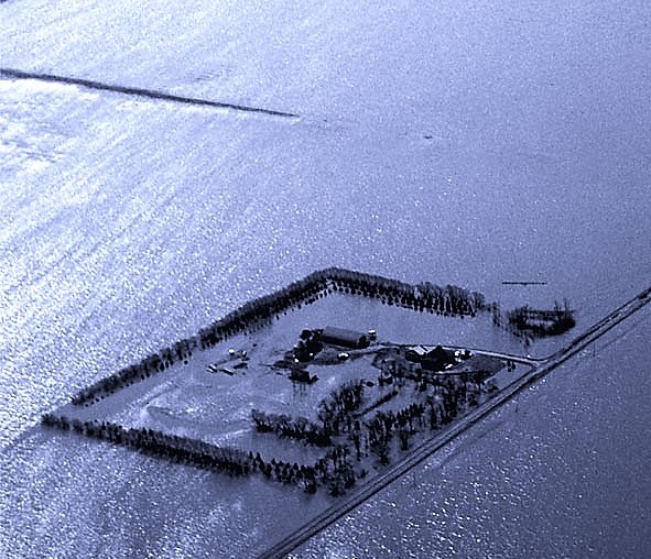
A Manitoba farmstead surrounded by Red River floodwaters in 1997.
May 2019
“Head’s up — you’re being activated; we need flood maps,” says a voice from Public Safety Canada on the other end of the phone. When this call comes in, as it always does, Natural Resources Canada emergency geomatics officer Simon Tolszczuk-Leclerc is already on alert. For weeks, Simon and the Emergency Geomatics Service (EGS) team have been following the spring thaw and river ice breakup. They know exactly what to do, and they’re ready to take immediate action.
Time is of the essence
Typically, this call comes when floodwaters are inching higher and higher to the point where municipalities realize they’re going to need all the resources they can get to manage the impending emergency. And when emergency responders are asking for a visual of what’s going on at ground level, every minute counts.
NRCan’s Canada Centre for Mapping and Earth Observation (CCMEO) emergency mapping unit is uniquely positioned to provide this crucial information quickly so Public Safety Canada, first responders and local communities can prioritize their mitigation and response efforts.
A real team effort
“If it’s just a small flood in small creek, municipalities can handle it,” says Simon. “But as you move up in scale and rivers get bigger and bigger, the provincial public safety offices often get called in. And when it’s even bigger, like in Ottawa–Gatineau in 2017, Public Safety Canada is brought into the mix, and they call us.”
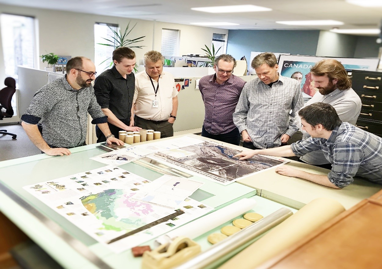
The emergency mapping unit at NRCan’s Canada Centre for Mapping and Earth Observation (CCMEO) have to react quickly to identify areas affected by flooding.
From start to finish, it takes the team under four hours — often much less — to process remote sensing data collected by Canada’s RADARSAT-2 Earth observation satellite, update web services and then share their findings with emergency responders and online. They have to move fast to quickly map the water extent and identify the areas that are most impacted by flooding. When they’re juggling multiple floods across multiple time zones, it can be intense.
Every year, every flood, every call is different
“It’s like a crescendo,” says Simon. “The first few days are critical. It’s a process of discovery — discovery of what’s impacted. It’s one thing to have imagery and another to make sense of it. And that’s where my team comes in: we interpret the scene: we try to find clues exactly where the flood is on the ground. That’s where our science and deductive abilities come in.”
As sure as there is spring in Canada, there will be flooding. In 2017 the call for help came from Gatineau, Quebec, then in 2018 for Saint John, New Brunswick, along with other small municipalities.
It happens every year, but every year it’s different, and the calls in 2019 could come from anywhere in Canada. That’s why the team relies on radar satellite imagery to map flood events. Radar can see through the cloud cover and observe floods to the centimetre level, even when there’s pouring rain. If the skies are clear, the EGS team can also count on optical imagery from satellites, aircraft or drones for accuracy up to one metre.
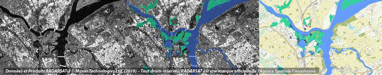
From left to right: a raw satellite image of Gatineau/ Ottawa flooding April 22, then with a first layer of flood analysis applied, and then final mapping product.
Eyes in the sky, ears to the ground
It’s important to have an eye in the sky, but it’s equally important to keep an ear to the ground. That’s why the team scours communications channels, news sources, the Internet, social media — Twitter, Instagram, Facebook — everything they can get their hands on. Soon, the smartphone app prototype that the team’s working on will let them combine their specialized satellite data with crowd-sourced photos and survey responses from emergency workers on the scene. With these additional, first-hand accounts provided by people on site and in the field, they can further tweak their maps, adding or removing areas to produce the most current, comprehensive and precise product.
Transcript
Lisa Edwards (Host):
Spring in Canada — it’s a wonderful time of the year! The weather gets warmer, the days get longer, and nature seems to wake from its winter slumber.
But for those of us who live near rivers or on low-lying land, the arrival of spring can also mean the beginning of a less joyous season — flood season.
Each year, flooding affects hundreds of thousands of Canadians and causes millions of dollars in damage.
The Government of Canada, including Natural Resources Canada, plays a role in helping people affected by potential floods manage the risks.
Find out more on today’s episode of Natural Elements.
Music intro
This is Natural Elements, and I’m your host, Lisa Edwards.
Natural Elements is a new podcast series brought to you by Simply Science, which is Natural Resources Canada’s online magazine. Like our sister podcast Ask NRCan, we talk to our experts about the work they do and how it relates to what’s happening around us. While Ask NRCan features in-depth discussions, Natural Elements offers you a quick overview, giving you a taste of the topic and letting you know where you can find more information.
We have a new schedule for our two podcast series. Our Ask NRCan episodes will be released on the first Tuesday of the month, with episodes of Natural Elements on the third Tuesday. Make sure to subscribe so you don’t miss an episode.
Let’s turn to today’s topic.
Floods are the most frequent natural hazard in Canada. Although they’re a natural part of healthy ecosystems, they can also cause human hardship and economic loss.
For some background on floods, here’s Simon Tolszczuk-Leclerc from Natural Resources Canada’s Emergency Geomatics Service:
Simon Tolszczuk-Leclerc:
Floods in Canada — they mostly happen in the spring, and they can be caused by a lot of different factors. Mostly, they occur because of the snowmelt and the heavy rain that spring sometimes knows. They can be accentuated by, let's say, the soil saturation and water that was pre-existing in autumn, for example, or even river ice jamming. Taken individually, each of those factors might not create a flood. But when you can combine them all, that's when you potentially have a recipe for disaster.
Lisa: In certain situations, local governments will seek help to manage flood risks.
Simon: When there's a major event that happens, well, the municipal and provincial public safety authorities will eventually request or ask for the help of the federal government to have access to some assets and resources that they don't necessarily have. At Natural Resources Canada, within the emergency mapping service, we use the Canadian satellite that's called RADARSAT 2 to do the mapping of flood extents in near real time. That means generally four hours.
Simon: As the images are acquired by the satellite, the NRCan receiving stations in Inuvik and Prince Albert and in Gatineau, in Cantley, will receive the data that will be downlinked by the satellite to our receiving station. And from that point on, we use our algorithms and our tools to extract the flood extent. Those flood extent layers, or maps, are then published and redistributed to the general public but also to our public safety partners.
Lisa: These maps can prove to be quite useful to the people on the ground, who need to quickly make informed decisions to minimize flood damage.
Simon: So, when the imagery is acquired and we create a map out of those images, we usually create map packages that we share with our partners. And those packages can be, well, it's either little files that you can load up on your computer or your phone or through just web pages. And without these images, our public safety officials wouldn't know exactly where the floods are. One of the main advantages of looking at Earth from space like that is it enables you to discover those impacted areas before being able to actually visit it for real.
Lisa: Although floods can be unpredictable at times, this satellite imagery makes it possible to do some forward planning.
Simon: We can't know for certain that a certain area will flood or not. But sometimes we do know that there are some areas that are more at risk than others, which is the case usually for the Red River or the Saint John River in New Brunswick, because these areas have tended to flood frequently in the past. And so, we're kind of always more at the ready for those areas, so we plan in advance to be able to do some river ice monitoring. And we plan in advance the satellite acquisitions that would enable us to be able to map more quickly the floods, if they were to come.
Lisa: In 2019, the Government of Canada will launch the RADARSAT Constellation, which is a series of three identical Earth-observation satellites. These new satellites will greatly improve our ability to assist governments and emergency workers in responding to floods.
Simon: One of the thing that’s coming up, well it's the new RADARSAT constellation mission. And so right now, with RADARSAT 2, we’re a bit limited. We’re only able to get an image every two, three days or so. But with the RADARSAT constellation, we'll be able to get an image every day. And so that will enable us and the responders to have a better view of what's going on in the field and really get a sense of the evolution of the situation. And then they'll be able to better respond because they have better information that is more timely at their disposal.
Lisa: The flood maps developed by our Emergency Geomatics Service can be of use even after the floods have receded.
Simon: We also keep all these layers in an archive, and that archive can be used by scientists and other land planners to know what has happened in the past to help them make better decisions and then inform future land planning.
Lisa: If you live in an area that’s prone to flooding, make sure you take the necessary precautions. We strongly recommend visiting our “Flood Ready” page on the Government of Canada website.
Links to flood maps produced by our Emergency Geomatics Service, as well as information on flood research and mapping at NRCan, can be found in the episode description.
Please subscribe to the Simply Science podcast channel to make sure you don’t miss future episodes of Natural Elements or its sister podcast AskNRCan.
If you want to learn more about the great scientific work that we do at Natural Resources Canada, check out our Simply Science website for great articles and our Simply Science YouTube channel to see our experts at work. Those links will be in the episode description as well.
Thank you, everyone, for listening! We’ll see you next month with a brand new episode.
Year-round work
After a busy couple of months, around the end of May, the EGS team will receive another call from Public Safety Canada: “The floods are receding; you can stand down.” That’s when they can breathe a sigh of relief, enter a recovery phase, review and report out. But that’s also when they hunker down and continue their research to improve flood mapping methods. Because more and more information becomes available all the time. Later this year, the team will be bringing new data on stream from Canada’s new RADARSAT Constellation Mission, which will improve the accuracy of their flood maps and the frequency of their updates.
Meanwhile, in another part of CCMEO, the Geoanalytics team is getting primed for their own, different emergency call: “Heads up — it’s wildfire season, and we need maps.”