
Stock take of Canada’s spatial data infrastructure, the Canadian Geospatial Data Infrastructure (CGDI)
June 2025
Canada Centre for Mapping and Earth Observation
Natural Resources Canada
Table of Contents
- CGDI Stock-Take Baseline Summary Report
- Executive summary
- 1. Introduction
- 2. Methodology
- 3. Findings
- 3.1 Phase I
- 3.2 Phase II
- 3.2.1 Strategic Pathway 1: Governance and institutions
- 3.2.2 Strategic Pathway 2: Policy and legal
- 3.2.3 Strategic Pathway 3: Financial
- 3.2.4 Strategic Pathway 4: Data
- 3.2.5 Strategic Pathway 5: Innovation
- 3.2.6 Strategic Pathway 6: Standards
- 3.2.7 Strategic Pathway 7: Partnerships
- 3.2.8 Strategic Pathway 8: Capacity and education
- 3.2.9 Strategic Pathway 9: Communication and engagement
- 4. The current state of the CDGI
- 5. Key insights and opportunities
- 6. Limitations
- 7. Conclusions
- Bibliography
Executive summary
Canada’s spatial data infrastructure (SDI), the Canadian Geospatial Data Infrastructure (CGDI) encompasses the collection of geospatial data, standards, policies, applications, and governance mechanisms that enable the access, use, and integration of spatial information. Effective geospatial information management in Canada plays a crucial role in advancing a broad spectrum of national priorities, including environmental monitoring, natural resource management, infrastructure planning, and public safety enhancement. Federal, provincial and territorial (FPT) partners, including the Canadian Council on Geomatics (CCOG) recognized the need to address key gaps within the CGDI and to inform domestic initiatives with international best practices and tools, such as those set out in the United Nations Integrated Geospatial Information Framework (UN-IGIF).
This stock-take exercise led by the Canada Centre for Mapping and Earth Observation (CCMEO) uses the global best practice model of the UN-IGIF as a framework for assessing the CGDI. The stock take includes the following data collection methods: 1) individual/small group interviews with a sample of provincial/territorial (PT) and federal government organizations undertaken by a third party; 2) online geospatial data producer and user inventories (surveys) to collect more detailed information from interviewee organizations; 3) a desk study (desktop research) and environmental scan (literature review) undertaken by a third party.
The findings of the above methods provide a window into the current state of the CGDI. Key insights unearthed through this exercise include coordination challenges arising from decentralized governance, the use of best practices and tools for open government processes, including implementation guidance for policy instruments, as well as the high levels of accessibility, findability, interoperability, availability and reusability of foundational data layers produced by participating federal and PT agencies and organizations. The stock-take findings also suggest an absence of linkages in fundamental datasets produced by participating organizations to Indigenous datasets, with potential implications for the pursuit of Indigenous data sovereignty. Financial support for geospatial data infrastructure is uneven and lacks sustainable investment models and ROI tracking, limiting long-term innovation and socio-economic impact assessment.
Opportunities for CGDI that were identified include the development of a pan-Canadian collaborative geospatial strategy, which is widely supported across federal and PT governments. Additionally, an opportunity exists to bolster innovation through public-private partnerships and academic collaborations driving the adoption of new technologies. These efforts would benefit from implementing sustainable funding models with regular ROI assessments to promote growth and innovation. Opportunities for advancing the CGDI also include addressing the current communication challenges by fostering unified engagement and developing a cohesive, targeted messaging strategy that emphasizes the economic and societal benefits of geospatial data, ensuring that geospatial initiatives are effectively communicated and widely understood across all sectors.
1. Introduction
1.1 The Canadian context
The UN-Integrated Geospatial Information Framework is anchored by nine strategic pathways:
- Governance and institutions
- Policy and legal
- Financial
- Data
- Innovation
- Standards
- Partnerships
- Capacity and education
- Communication and engagement
Geospatial information management in Canada is pivotal for addressing a wide range of national priorities, from monitoring environmental changes and managing natural resources to supporting infrastructure development and enhancing public safety. Governance of the CGDI is complex and has a decentralized structure, involving multiple levels of government and various federal departments and agencies. While this distributed approach fosters domain-specific expertise, challenges emerge in coordination, data sharing, and the development of a unified strategy that can effectively leverage geospatial information across the country. FPT partners, including the CCOG, have highlighted the importance of addressing gaps in the CGDI and leveraging international best practices and tools, such as those outlined by the UN-IGIF.
This CCMEO-led stock-take exercise uses the global best practice model of the UN-IGIF as a framework for assessing the CGDI, which refers to the collection of geospatial data, and the standards, policies, applications, and governance that facilitate its access, use, integration, and preservation in Canada.
This stock-take exercise includes the following data collection methods: 1) Individual/small group interviews with a sample of PT and federal government organizations, undertaken by a third party; 2) Online geospatial data producer and user inventories (surveys) to collect more detailed information from interviewee organizations; and 3) a desk study (desktop research) undertaken by a third party.Footnote 1
1.2 Overview of IGIF framework
The UN-IGIF establishes guidelines for developing, integrating, strengthening and advancing geospatial information management and related assets globally. It aims to support countries in bridging the digital divide across geospatial domains while promoting socio-economic success. The UN-IGIFFootnote 2 consists of three separate components that build on one another: 1) an Overarching Strategy, summarized in Figure 1, which presents a leading edge Framework adaptable to national needs and circumstances, including strategic drivers and an outlined expansive and integrated national framework, which emphasizes policy, underpinning principles and goals for geospatial information management; 2) a detailed Implementation Guide, which outlines concrete guidance, opportunities and suggested actions for Member States to strengthen their geospatial information management; and 3) a Country-level Action Plan, which offers practical guidance for executing recommendations from the Implementation Guide, including detailed processes, resource materials, templates and examples that can be used to develop a country-wide action plan aligned with national priorities and circumstances.
1.2.1 IGIF strategic pathways
This stock-take exercise draws from an IGIF Baseline Assessment Diagnostic Tool included in the Country-Level Action Plan as well as related templates published by the World Bank in 2020. The Baseline Assessment Diagnostic Tool was designed to provide an assessment of the current state of participating countries’ geospatial information management, structured around nine themes or “strategic pathways”: governance, policy and legal, financial, data, innovation, standards, partnerships, capacity and education and communication and engagement. The tool included a detailed list of multiple-choice questions, along with response options and an accompanying ranking scale, for each strategic pathway. Figures 1 and 2 provide context for and an overview of the UN-IGIF strategic pathways, which are described below.
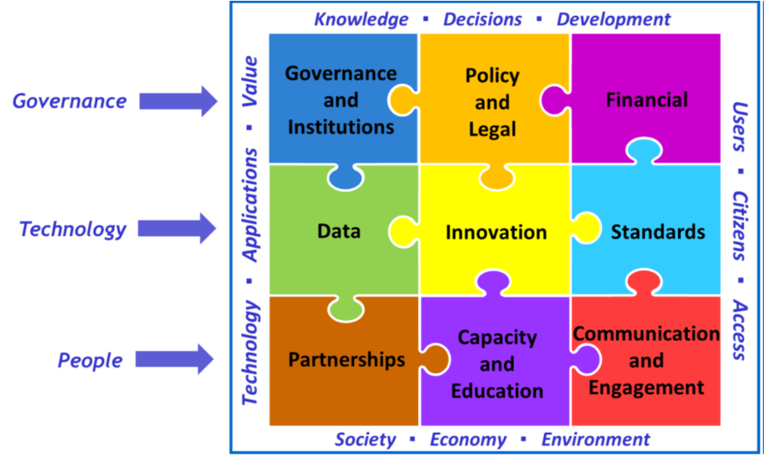
Figure 1. UN-IGIF Strategic Pathways.
Text description
The nine strategic pathways are:
- Governance and Institutions
- Policy and Legal
- Financial
- Data
- Innovation
- Standards
- Partnerships
- Capacity and Education
- Communication and Engagement
When the strategic pathways are implemented, they can have several benefits on knowledge, decisions, development, users, citizens, access, society, economy, environment, technology, applications and value.
Strategic Pathway 1 - Governance and institutionsFootnote 3: The governance and institutions strategic pathway establishes the leadership, governance model, institutional arrangements, and a clear value proposition to strengthen multi-disciplinary and multi-sectoral participation in, and a commitment to achieving an IGIF. The objective is to attain political endorsement, strengthen institutional mandates and build a cooperative data sharing environment through a shared vision and understanding of the value of an IGIF, and the roles and responsibilities to achieve the vision.
Strategic Pathway 2 - Policy and legal: The policy and legal strategic pathway establishes a robust policy and legal framework that is essential for instituting effective, efficient, and secure management and exchange of geospatial information - nationally and sub-nationally. The objective is to address current policy and legal issues by improving the policies and laws associated with, and having an impact on, geospatial information management. This is achieved by proactively monitoring the policy and legal environment, including mandating responsibility for the production of data, and keeping abreast of issues and challenges arising from the evolving, innovative and creative use of geospatial information and emerging technologies.
Strategic Pathway 3 - Financial: The financial strategic pathway establishes the business model, develops financial partnerships, and identifies the investment needs and means of financing for delivering integrated geospatial information management, as well as recognizing the milestones that will achieve and maintain momentum. The objective is to achieve an understanding of the financial plans required to establish and maintain an integrated geospatial information management, as well as the longer-term investment program that enables government to respond to evolving societal, environmental and economic demands for geospatial data.
Strategic Pathway 4 - Data: The data strategic pathway establishes a geospatial data framework and custodianship guidelines for best practice collection and management of integrated geospatial information that is appropriate to cross-sector and multidisciplinary collaboration. The objective is to enable data custodians to meet their data management, sharing and reuse obligations to government and the user community through the execution of well-defined data supply chains for organizing, planning, acquiring, analyzing, integrating, aggregating, curating, publishing and archiving geospatial information.
Strategic Pathway 5 - Innovation: The innovation strategic pathway recognizes that innovation has the potential to stimulate, trigger and respond to rapid change, leapfrog outdated technologies and processes, and to bridge the geospatial digital divide. Technology is continually evolving, creating new opportunities for innovation and creativity. The objective is to leverage the latest cost-effective technologies, innovations and process improvements so that governments, businesses and academia, no matter their current situation, may leapfrog to modern geospatial information management systems and practices. Since there is no explicit pathway for technology in the IGIF, technology indicators have been integrated in this pathway.
Strategic Pathway 6 - Standards: The standards strategic pathway establishes and ensures the adoption of best practice standards and compliance mechanisms for enabling data and technology interoperability to deliver integrated geospatial information and location-based knowledge creation. The objective is to enable an efficient and consistent approach for different information systems to be able to discover, manage, communicate, exchange and apply geospatial information for a multitude of uses, improved understanding and decision-making.
Strategic Pathway 7 - Partnerships: The partnerships strategic pathway establishes cross-sector and interdisciplinary cooperation, coordination and collaboration with all levels of government, the geospatial industry, private sector, academia, and the international community, as an important premise to developing and sustaining an enduring nationally-integrated geospatial information framework. The objective is to create and sustain the value of geospatial information through a culture based on inclusion, trusted partnerships and strategic alliances that recognize common needs, aspirations and goals, towards achieving national priorities and outcomes.
Strategic Pathway 8- Capacity and education: The capacity and education strategic pathway establishes enduring capacity development and education programs so that the value and benefits of integrated geospatial information management is sustained for the longer term. The objective is to raise awareness, build and strengthen knowledge, competencies, skills, instincts, processes, resources, and innovative entrepreneurship that organizations, communities and individuals require to utilize geospatial information for evidence based decision-making and effective service delivery.
Strategic Pathway 9 - Communication and engagement: The communication and engagement strategic pathway recognizes that stakeholder identification, user engagement and strategic communication are essential to successfully deliver integrated geospatial information management arrangements nationally and sub-nationally for sustainable social, economic and environmental development. The objective is to ensure effective communication and engagement to enhance and deepen participation and contributions from all stakeholders and at all levels. Commitment, mutual understanding, collaboration, cooperation and communication are essential to successfully implement the IGIF within organizations and with stakeholders.
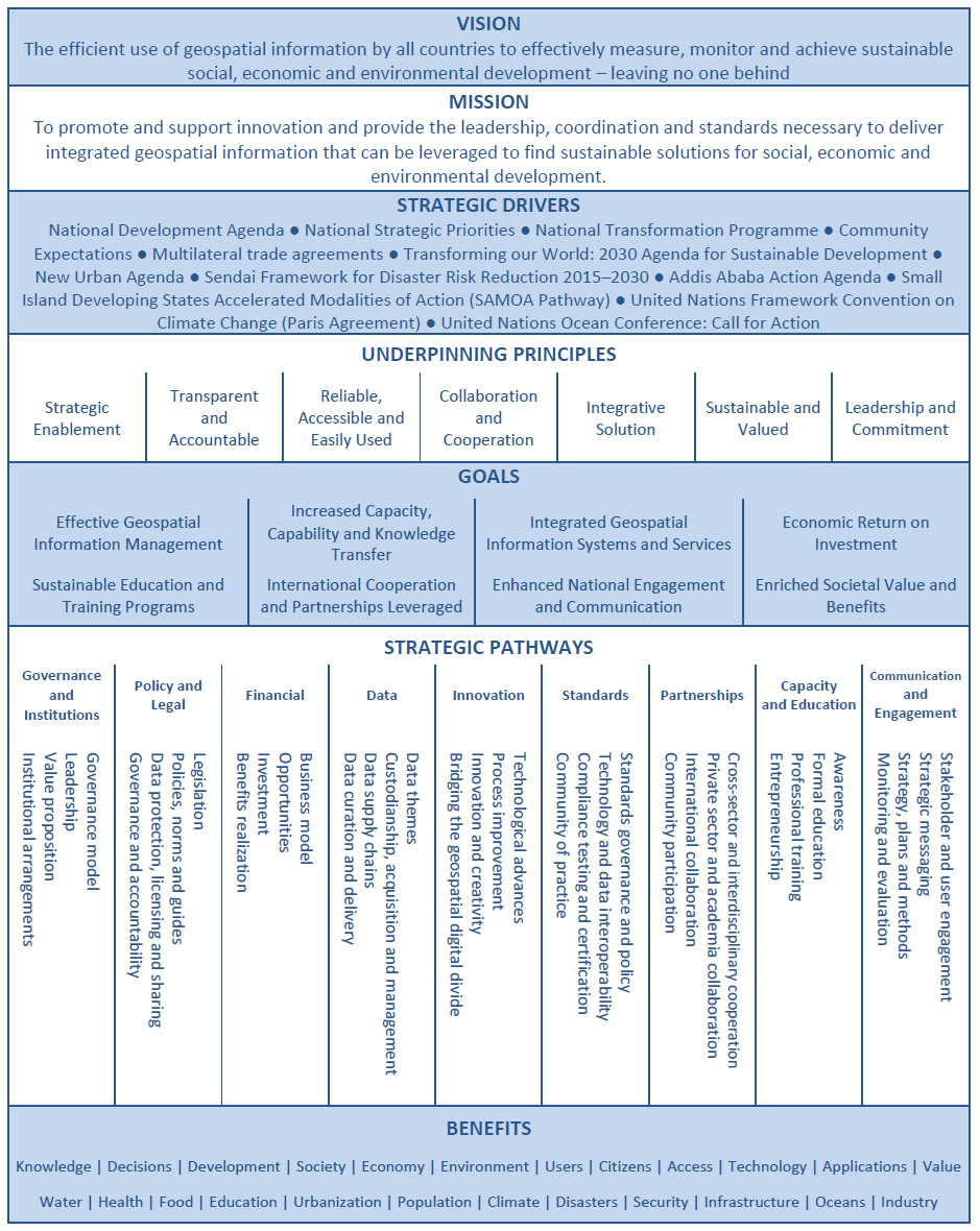
Figure 2. UN-IGIF , including the vision, mission, strategic drivers, underpinning principles, goals and strategic pathways.
Text description
Vision: The efficient use of geospatial information by all countries to effectively measure, monitor and achieve sustainable social, economic and environmental development – leaving no one behind
Mission: To promote and support innovation and provide the leadership, coordination and standards necessary to deliver integrated geospatial information that can be leveraged to find sustainable solutions for social, economic and environmental development.
Strategic drivers:
- National Development Agenda
- National Strategic Priorities
- National Transformation Programme
- Community Expectations
- Multilateral trade agreements
- Transforming our World: 2030 Agenda for Sustainable Development
- New Urban Agenda
- Sendai Framework for Disaster Risk Reduction 2015–2030
- Addis Ababa Action Agenda
- Small Island Developing States Accelerated Modalities of Action (SAMOA Pathway)
- United Nations Framework Convention on Climate Change (Paris Agreement)
- United Nations Ocean Conference: Call for Action
Underpinning principles:
- Strategic Enablement
- Transparent and Accountable
- Reliable, Accessible and Easily Used
- Collaboration and Cooperation
- Integrative Solution
- Sustainable and Valued
- Leadership and Commitment
Goals:
- Effective Geospatial Information Management
- Sustainable Education and Training Programs
- Increased Capacity, Capability and Knowledge Transfer
- International Cooperation and Partnerships Leveraged
- Integrated Geospatial Information Systems and Services
- Enhanced National Engagement and Communication
- Economic Return on Investment
- Enriched Societal Value and Benefits
Strategic Pathways:
- Governance and Institutions
- Governance model
- Leadership
- Value proposition
- Institutional arrangements
- Legal and Policy
- Legislation
- Policies, norms and guides
- Data protection, licensing and sharing
- Governance and accountability
- Financial
- Business model
- Opportunities
- Investment
- Benefits realization
- Data
- Data themes
- Custodianship, acquisition and management
- Data supply chains
- Data curation and delivery
- Innovation
- Technological advances
- Process improvement
- Innovation and creativity
- Bridging the geospatial digital divide
- Standards
- Standards governance and policy
- Technology and data interoperability
- Compliance testing and certification
- Community of practice
- Partnerships
- Cross-sector and interdisciplinary cooperation
- Private sector and academia collaboration
- International collaboration
- Community participation
- Capacity and Education
- Awareness
- Formal education
- Professional training
- Entrepreneurship
- Communication and Engagement
- Stakeholder and user engagement
- Strategic messaging
- Strategy, plans and methods
- Monitoring and evaluation
Benefits: Knowledge, Decisions, Development, Society, Economy, Environment, Users, Citizens, Access, Technology, Applications, Value, Water, Health, Food, Education, Urbanization, Population, Climate, Disasters, Security, Infrastructure, Oceans, Industry
1.3 Stock-take phases and timeline
The stock-take results summarized in this report represent Phase I and II of a longer timeline:
Phase I, the scoping and socializing phase of the stock-take exercise, involved the adaptation of the World Bank IGIF Diagnostic tool, a preliminary in-house CCMEO consultation, and a Gender-based Analysis Plus (GBA+) assessment. Phase I was completed between September 2022 and April 2024.
Phase II, which was completed between May 2024 and December 2024, included four components: 1) individual/small group interviews with a sample of PT and federal government organizations; 2) online geospatial data producer and user inventories (surveys) to collect more detailed information from interviewee organizations; 3) a desk study (desktop research) undertaken by a third party; 4) in addition, a third party environmental scan was undertaken (literature review). An overview of this environmental scan is not included in this report, as it did not provide a stock take of the CGDI per se, but rather an overview of trends in geospatial technologies and strategies relevant to the CGDI.
Phase III, conducted between February and May 2025, is a visioning exercise consisting of engagement with non-governmental partners and stakeholders.
Phase IV, July – December 2025, involves a gap analysis and development of a collaborative, pan-Canadian geospatial data strategy, followed by accompanying implementation plans (forthcoming).
The phases progress cumulatively, with each building on the findings of the previous one. This report focusses on the results of Phase I and Phase II, which are used to design and execute subsequent phases.
1.4 Report structure
Part 1 of this report provides background on the CGDI, including the current context and geospatial landscape. It also summarizes the World Bank IGIF framework used as a lens for this analysis, based on the nine strategic pathways defined in 1.21.
Part 2 of the report outlines the methodologies employed in Phase I (adaptation of the World Bank IGIF diagnostic tool, CCMEO internal consultation) and Phase II (interviews, inventory, desk study) of the CGDI stocktake.
Part 3 highlights the results of Phase II interviews, inventory and desk study, including key findings along each strategic pathway and corresponding scores, as well as additional insights and considerations for each. It also outlines the overall scored results for the CGDI along each strategic pathway.
Part 4 identifies overarching trends and provides an overview of the current state of the CGDI. Part 5 highlights key insights and opportunities for growth drawing from the stock-take findings summarized and discussed in Parts 3 and 4. Next steps for the stock take are discussed in Part 6, followed by limitations (Part 7) and conclusions (Part 8).
2. Methodology
2.1 Phase I
2.1.1 Adaptation of the IGIF diagnostic tool
From 2022 to 2023, subject matter experts representing each division at the Canada Centre for Mapping and Earth Observation (CCMEO) worked to adapt the questions from the World Bank Diagnostic Tool to improve their alignment with the Canadian context, developing customized response options and corresponding rankings.
Diagnostic tool adaptation
The diagnostic tool adaptation process was undertaken with the following questions in mind:
- Does the tool design reflect best practices in a methodological sense? Are questions and response options clear and designed to produce results that are valid and reliable?
- Which particular concepts need to be adapted to account for Canada’s distributed authorities, including the multi-jurisdictional / federated aspect?
- Are we are seeking a jurisdictional, national and/or federal level perspective from respondents?
- Do the adaptations reflect Canada’s policy objectives?
- Who are the targeted stakeholders and partners for this initiative?
Before commencing the tool adaptation, the project team consulted with personnel who led the IGIF exercise for other countries, including Ireland and Germany. The procedure followed an adaptation protocol developed by the stock-take project team to ensure a transparent, methodologically sound and policy-relevant outcome. The protocol established guidelines for changes to the tool addressing methodological considerations (e.g., enhancing tool design, tailoring content to available expertise, improving question clarity) as well as policy considerations (e.g., modifications reflecting Canadian context and/or Canada’s policy priorities, federal policies on accessibility, official languages, etc.).
2.1.2 Consultation with internal experts
A first phase of consultations was undertaken with internal-to-CCMEO experts along with CCMEO senior managers. These initial consultations involved an assessment of a subset of diagnostic questions related primarily to the overarching governance and policy/legal instruments underpinning the CGDI, for which CCMEO is responsible under the GeoConnections program.
Throughout Phase II, regular meetings were held with internal experts to provide updates on the stock-take progress. Internal experts were asked to review and provide input to first drafts of reports summarizing the results of the interviews, desk study and inventory. This input is incorporated throughout the Phase II findings summarized in 3.2 under the heading “Internal expert commentary”.
2.1.3 GBA+ and engagement analysis
In fall 2024, a GBA+ and engagement analysis was conducted ensure that the stock take and approach to developing a location data strategy is inclusive and consider the diverse needs and experiences of Canadians. The GBA+ engagement analysis used resources provided by Natural Resources Canada’s (NRCan) Audience and Engagement Unit, NRCan’s Nòkwewashk and Women and Gender Equality Canada. The analysis was completed by CCMEO using a template provided by Women and Gender Equality Canada (accessed September 2024) as a best practice. The findings were used to support the steps to develop a collaboration geospatial strategy for Canada (Phase IV) and associated public engagement (Phase III).
2.2 Phase II
2.2.1 Interviews
The interview component of the stock-take was completed by a third party, Gelder, Gingras & Associates Inc. Individual/small group interviews were conducted with federal and PT government officials. Interview subjects were familiar with the CGDI and came from a variety of roles. Participants were identified through their participation with the Canadian Council on Geomatics – Canada’s national geospatial collaborative body – as well as through identification by senior managers within NRCan. Qualitative data was collected via 20 virtual interviews and 3 written responses to interview questions from a total of 28 respondents (accounting for group interviews). Interviews took approximately 1-1.5 hours and were conducted in July and August 2024. Interviews were conducted with 7 participants from 6 provinces/territories, as well as with 24 federal participants representing 10 departments and agencies.
2.2.2 Inventory
The stock-take inventory component was administered in survey format using cloud-based Qualtrics software. The survey link was circulated to three lists of potential respondents: 1) members of the Canadian Council on Geomatics; 2) subjects who had already participated in the interview component of the stock take; and 3) subject matter experts internal to NRCan. Inventory responses were collected between October 16th, 2024, and November 15th, 2024.
Two versions of the inventory were administered, one targeting geospatial data users and another targeting geospatial data producers. Respondents identifying as both data users and producers were asked to complete both surveys. Overlap in questions between the two versions was significant, with most differences concentrated in questions assessing the data strategic pathway.
It should be noted that inventory questions are not evenly distributed between strategic pathways. For example, the inventory includes only two questions exploring the financial strategic pathway, while 14 are included in the producer version of the data strategic pathway. The partitioning of questions between these categories reflects their suitability for analysis using a survey-type approach, as well as their coverage by the interviews and desk study. Some of the strategic pathways (e.g., communication and engagement) were excluded from the inventory for this reason, while others (e.g., financial) were included to a limited extent. Notes regarding subsequent limitations are provided in the results sections below.
2.2.3 Desk study
A desk study was prepared by a third party, Hatfield Consultants LLP, who provided an independent assessment of the current position of geospatial information management in Canada. This was completed through desktop research of publicly available information, and professional opinion and knowledge of the CGDI. The desk study findings were used to assign scores for questions from the adapted diagnostic tool across all nine strategic pathways following the scoring approach detailed below.
2.2.4 Adapted scoring approach
The questions in the stock-take exercise were adapted considerably from the original World Bank template to accommodate the Canadian context, including shared jurisdictional responsibilities. However, maintaining some alignment to the IGIF’s diagnostic template and recommendations for analysis enables us to learn from those countries who have utilized the IGIF tool, and situate Canada’s geospatial information framework among those of our international counterparts, to help identify potential gaps and opportunities.
Similar to the original Diagnostic tool published by the World Bank, responses to the adapted questions collected via the three stock-take components were analysed using a 5-point ranking scale . This particular ranking design was well suited to the original diagnostic tool because of its survey format and multiple-choice questions, which typically included 5 response options used to indicate a sliding scale of proficiency in each of the strategic pathway themes. In the Canadian version, many of these multiple-choice questions were converted to more open-ended formats (e.g., open fill in the case of the inventory or open-ended questions in the case of the interviews), and then scored accordingly.
3. Findings
3.1 Phase I
3.1.1 Internal expert consultation
Phase I aimed to capture the perspective of Canada’s lead coordinating organization for geospatial information management. It also provided the opportunity to test a sub-set of the adapted IGIF questions, which informed the revision of the survey for future stock-take phases. The Phase I findings suggest that in Canada, much of the work and functions are being undertaken in an ad hoc or distributed manner. Often, this occurs in the absence of the formal mechanisms and structures identified in the UN-IGIF, which presuppose national-level authorities that do not necessarily exist in the Canadian context due to its federated nature.
The findings from Phase I are summarized below:
Monitoring and evaluation framework: Although a loosely defined set of evaluation criteria may exist, no evidence of a formally established monitoring and evaluation framework and associated set of Key Performance Indicators (KPIs) at the national level was identified. Individual FPT organizations with geospatial functions each have their own legal requirements related to reporting and evaluation, but these are not rolled up to the national level. At the national level, a CGDI Web Harvester can be used to informally assess the CGDI via tracking of the availability of standards-based services in the .ca domain. Overall, respondents noted the absence of a pan-Canadian policy and legal framework, indicating this represents a challenge, gap, or opportunity. This remains a valuable discussion area for the future.
Policy working group: National-level policy work is being done on an ad-hoc basis. Respondents indicated that there is no single policy working group at the national level that has been established. To qualify this statement: 1) the Canadian Council on Geomatics (CCOG) addresses and identifies shared priorities among its FPT representatives who each have specific jurisdictional responsibilities; 2) the GeoConnections program within CCMEO has a mandate for national-level coordination, and maintains relationships and connections with different jurisdictions and organizations, though it holds no authority over the policies of other jurisdictions/organizations. To note, there is also the Geographical Names Board of Canada (GNBC), which is a secretariat managed and housed by NRCan, but it is also subject to the distributed authorities across Canada. Some organisations and jurisdictions have established bilateral relationships with stakeholders/partners across government, private sector, academia and civil society; however, there is no overarching national policy working group with dedicated authorities to facilitate this.
Needs assessment for a policy and legal framework: Needs assessments have been completed; for example, in 2019, a CGDI user needs assessment explored gaps and needs from a pan-Canadian perspective (including policy needs). However, given distributed authorities, there is no single consolidated policy and legal framework.
Government generated data licensing agreements to facilitate the sharing of geospatial data: Canada shares open data via Open Government Licence-Canada at a federal level, and most provinces and territories have adopted a similar approach. Licensing depends on the data and its nature (e.g. regulated data, data of different levels of sensitivity, privately owned/generated data, etc.). This open licensing can be contrasted with other data that are privately owned but contracted by government, and data that have a regulatory function, which varies by data type. Where data licensing restrictions exist, this is typically due to a combination of factors that render the data sensitive (e.g. security, geopolitical factors, expertise requirements, etc.). Non-regulated and non-government generated data are subject to other data licensing restrictions on a case-by-case basis.
Pan-Canadian Geospatial Innovation Strategy: While some functions that would be included in a strategy are being undertaken, no formal pan-Canadian strategy currently exists. Some Phase I participants pointed to the 2015 Assessment of the CGDI, as well as the 2019 CGDI user needs assessment as a starting point for strategic thinking.
International and regional collaborations: Collaborations exist, but there is no policy statement or objective outlining guidance for international and regional (global) collaborations. Examples provided by respondents included the existence of Memorandums of Understanding (MOUs) with other countries; participation in existing regional and international tables such as the Arctic Spatial Data Infrastructure (Arctic SDI) and United Nations Committee of Experts on Global Geospatial Information Management (UN-GGIM); membership with international standards organizations such as the Open Geospatial Consortium (OGC) and World Wide Web Consortium (W3C). It was noted that a policy statement or objective could help formalize requirements around access and participation.
Priority areas and assessment for capacity development: Although there is awareness, existing assessments and discussion on the mechanisms that could be useful for capacity development, formal mechanisms and a strategy have not yet been put in place. Participants pointed to the 2015 Assessment of the CGDI and the 2019 CGDI user needs assessments, which contained recommendations for supporting capacity development. However, no long-term national level strategy has been developed. To note, training/education are PT jurisdiction.
Established link between the CGDI and the UN Sustainable Development goals: Although work is being undertaken that may align with the UN Sustainable Development goals, it is completed on an ad-hoc basis and not anchored in any one formal mechanism.
3.1.2 GBA+ and engagement analysis
Key recommendations from the GBA+ analysis, that have informed engagement activities, are summarized below:
Participation: Moving into Phase III of the development of this strategy, it is recommended to broaden engagement to include more user experiences across stakeholder/partner groups, and to keep the problem (why) statement flexible as these needs are further defined. Engagement in the next phase should be targeted to ensure participation from a variety of user groups to avoid bias.
Data: It is recommended to support the refinement of the problem statement and gaps/needs analysis with significant sources of quantitative data, including a potential socio-economic benefit analysis and case studies. This data should be disaggregated where possible.
Access: Engagement should be language neutral (i.e. not technical jargon) and enable a variety of methods/timelines for providing input.
Impact: Engagement sessions, notably roundtables, may be organized by topic, ensuring a variety of stakeholders and partners from varying impact levels are involved. A roundtable is particularly recommended focused on geospatial data for emergency management in Canada, to ensure reflection of this important dependency.
FPT contributors: 1) Provide CCOG (and GNBC) members with the opportunity to review the roundtable topics (Phase III) and participant categories before invitations are sent; and 2) ensure criteria for selecting participants is made clear to CCOG/GNBC members (diversity of user categories, jurisdictions, stakeholder groups).
3.2 Phase II
Following an adapted IGIF Baseline Assessment tool approach, interview, inventory and desk study results were scored on a 5-point scale. This section outlines the scored results for each stock-take component organized according to strategic pathway.
It should be noted that the total average score of each strategic pathway was calculated by averaging scores for each question from the diagnostic tool within each strategic pathway, which were divided (sometimes unevenly) between the three stock-take components.
3.2.1 Strategic Pathway 1: Governance and institutions
The governance of geospatial information management in Canada is characterized by a multifaceted and decentralized structure, with varying roles and responsibilities across different levels of government, as well as among federal departments and agencies. Federal and PTs practitioners use geospatial data to support a diversity of operational priorities addressing an array of issues across a variety of domains. The results summarized in this section, which were derived from data collected in the interview, inventory and desk study stock-take components, highlight coordination gaps arising from a decentralized governance structure, underscoring the need for a pan-Canadian geospatial strategy and enhanced coordination.
| Stock-take component | Overview | Average score |
|---|---|---|
| Interviews | Certain federal agencies and departments (e.g., NRCan) demonstrate strong capacities in managing geospatial information, with effective leadership in specific areas. However, the governance of geospatial information in Canada is highly decentralized, leading to significant coordination challenges. The absence of a centralized governance structure results in uncoordinated efforts across jurisdictions. | 25 |
| Inventory | Participating organizations use geospatial data to support a wide range of operational priorities addressing a diversity of issues across a variety of domains. The score reflects a perceived need for increased leadership in CGDI matters, potentially in the form of a pan-Canadian geospatial or location data strategy, to offer guidance for geospatial data use and production to support Canada’s federal and PT operational priorities. | 16.4 |
| Desk study | Several PTs have published recent geospatial information management strategies, but the most recent national strategy is more than 10 years old. While the benefits of the CGDI including its components (data, policies, standards, technologies, resources, and collaboration) are articulated, no simple value statement is available or published on a CCMEO website. A Monitoring and Evaluation Framework and associated set of KPIs for GeoConnections or CGDI activities are not publicly available. | 66.7 |
| Total average score | 52.6 | |
Trends in CGDI governance and institutions
- Decentralization and coordination challenges
The federal government's approach to geospatial information management is highly decentralized, with different sectors managing their infrastructure independently. While this allows specific domains like agriculture or transportation to develop tailored capabilities, it has led to a perceived weakening of centralized leadership, particularly from NRCan. Canadian governance is often described as 'federated' or ‘distributed’ where different jurisdictions, federal departments and agencies, and even municipalities work somewhat independently, leading to challenges in integrating and coordinating efforts across the country. While some federal agencies like NRCan and Statistics Canada have significant capacity and play leading roles, this is not consistent across all jurisdictions – and from some perspectives, there are conflicting or diverging approaches to geospatial data infrastructure and management. Federal agencies and departments like NRCan are recognized for their strong capacity, particularly in areas like standards development. However, there is an ongoing challenge to coordinate and integrate geospatial information across different jurisdictions and levels of government.
- Self-sufficiency and limited collaboration
Some PT respondents emphasized their self-sufficiency, evidenced in their strong internal geospatial management capabilities with minimal reliance on federal coordination. However, this self-sufficiency can lead to limited collaboration across provinces and with the federal government, resulting in disparities in geospatial data management and integration. PT governments reported significant gaps in coordination and communication with federal entities.
- Value statement and KPI monitoring
Despite the long history of leadership and coordination of the CGDI through NRCan’s GeoConnections program, no up-to-date value statement is publicly available.
- Absence of a unified national strategy
Results from the interviews, inventory and desk study highlight the lack of a cohesive national strategy and divergence among PTs with differing geospatial capabilities. This disparity is exacerbated by the absence of a clear, centralized governance structure at the national level, which in turn leads to inefficiencies, duplication of efforts, and gaps in data coverage.
Internal expert commentary
CCMEO has communicated the geospatial value proposition for priorities including emergency response and flood mapping. Its work on standardizing emergency response mapping products supports CGDI leadership goals by establishing consistent, high-accuracy data protocols. The GeoBase program and efforts in open data governance reflect the Governance and Institutions strategic pathway’s objectives for data accessibility and cross-jurisdictional governance standards. CCMEO has also committed to supporting Canada’s Open Government priorities and the 2022-24 National Action Plan, and facilitates FPT collaborations (e.g., Open Government Portal, GEO.ca and the Open Science and Data Platform (OSDP)) to promote data sharing.
Within the federal government, structural elements do not encourage national-level leadership and coordination. For example, program funding is often allocated to individual groups, limiting incentives to broadly collaborate. Exploring opportunities to modify such limitations may improve geospatial leadership and coordination.
3.2.2 Strategic Pathway 2: Policy and legal
The legal and policy framework governing geospatial data management in Canada is marked by significant decentralization and siloing across various levels of government and federal departments and agencies. While there are some standards and guidelines in place, the application and effectiveness of these frameworks are inconsistent, leading to a mixed landscape where geospatial data requirements are not uniformly met. Despite this decentralization, CCOG is a vehicle for federal and PT collaboration, though it excludes Indigenous organizations, the private sector, civil society and academia. The results summarized in this section were derived from data collected in the interview and desk study stock-take components.
| Stock-take component | Overview | Average score |
|---|---|---|
| Interviews | There are established legal frameworks that guide the management of geospatial data, particularly in specific sectors such as national defense and natural resources. However, these legal and policy frameworks are inconsistent and uncoordinated across different levels of government, leading to challenges in data integration and sharing. | 35.7 |
| Desk study | CCOG is a “consultative inter-governmental forum” for FPT governments to discuss items including proposed legislation, though it excludes Indigenous organizations, the private sector, civil society and academia. While a policy and legal framework for the CGDI is not in the public domain, federal and provincial/territorial laws, policies and arrangements encourage, promote and enable open data, data sharing, data protection and privacy measures, upholding of intellectual property rights (IPR), and protection of liability. | 72.5 |
| Total average score | 55 | |
Trends in CGDI policy and legal oversight
- CCOG as a “consultative inter-governmental forum”
CCOG is a “consultative inter-governmental forum”, providing a venue for FPT governments to discuss items including proposed legislation (CCOG 2024). However, CCOG does not include Indigenous, private sector, academia and civil society membership, nor does it fill the role of an independent policy and legal working group.
- Lack of centralized policy and legal framework
Interview results suggest that PT respondents generally perceive the legal and policy framework as inadequate, underscoring the lack of a centralized national legal framework and the challenges posed by varying provincial legislation and regulations. The absence of a unified national policy is believed to create discrepancies in data management practices across provinces and territories.
- Nonbinding policies overseeing CGDI
At the federal level, several Treasury Board policies and guidance are relevant to the CGDI, including:
- A Policy and Guideline on Service and Digital: An integrated set of rules that articulate how Government of Canada (GC) organizations manage service delivery, information and data, information technology, and cyber security in the digital era (Government of Canada 2019; Government of Canada 2024b).
- Directive on Open Government: A directive to maximize the release of government information and data of business value to support transparency, accountability, citizen engagement, and socio-economic benefits through reuse, subject to applicable restrictions associated with privacy, confidentiality, and security (Government of Canada 2014).
Collectively, these policies, guidelines, and directives help to ensure consistent approaches to open data and information practices across government. In addition, the Geomatics Accord, which is part of the policy and legal framework supporting the CGDI, enables FPT collaboration on geomatics issues. It also establishes common geographical data standards, while sharing the cost of creating and maintaining national databases
- Decentralization and inconsistent application of standards
While there are efforts to develop standards, such as those supported by the Treasury Board and NRCan, these are often seen as time-consuming and not necessarily beneficial in practice. The disproportionate focus on standards development over practical application, as noted by some federal interview participants, reflects a broader issue within the federal approach to geospatial data management. While acts and guidelines exist, they often do not directly address geospatial information, resulting in inconsistent application across departments and agencies.
- Coordination challenges and departmental silos
The Federal Geospatial Platform (FGP), which once provided a cohesive framework, still has its merits, but overall coordination at the federal level is viewed as being siloed. Some federal interview respondents acknowledged gaps in cooperation and data sharing, which are exacerbated by the lack of a central governing body for geospatial data. Similar to the federal perspective, PT interview respondents emphasized the autonomy of individual jurisdictions, which often leads to disparities in geospatial data management. The responses reveal frustration over the lack of coordination with federal entities, with some provinces standing out for their strong legal framework, while others lag behind.
Privacy concerns and inconsistent regulations were cited by interview respondents as significant barriers to data sharing. The need for better policies to facilitate data sharing, particularly with Indigenous communities, were also highlighted.
Internal expert commentary
NRCan-CCMEO’s focus on open data governance and the GeoBase initiative supports the legal and policy strategic pathway by establishing structured, legally compliant frameworks for geospatial data access. Their emergency response mapping standards are designed to comply with legal requirements, supporting data policies that facilitate public safety and transparency.
The 2012 Standard on Geospatial Data was mandated across the Federal Government. The Treasury Board Secretariat and CCMEO are in the process of consulting with federal and PT stakeholders to modernize the standard. The updated standard will include new geospatial reference standards that are voluntary as well as those that mandatory for all GC departments and agencies, so that data/metadata can be easily shared and interoperable across various systems and platforms.
The FGP initiative by the GC aimed to provide a collaborative, online environment for accessing, managing, and sharing authoritative geospatial data and services. While still operational, the platform is no longer the primary tool for many federal departments and agencies. However, the FGP’s catalogue and data continue to be leveraged by more than 25 federal departments and agencies and CCMEO continue providing data and geospatial applications to platforms such as Canada.ca, the Open Science and Data Platform, GEO.ca, and The Atlas of Canada.
3.2.3 Strategic Pathway 3: Financial
Public financial resources related to geospatial information and its management in government are characterized by varying levels of adequacy, utilization, and sustainability across different departments/agencies and jurisdictions. While some reported adequate resources for maintaining current operations, the overall picture reveals a lack of sustainability and challenges in realizing the full potential of geospatial investments, particularly when it comes to moving beyond the data acquisition stage (e.g. archiving, storing, maintaining data). These challenges may be compounded by gaps in the tracking of return-on-investment (ROI) of CGDI financing reported by some federal departments/agencies and PTs. The results summarized in this section were derived from data collected in the interview, inventory and desk study stock-take components.
| Stock-take component | Overview | Average score |
|---|---|---|
| Interviews | Some departments and agencies have managed to secure adequate funding to maintain their current operations and support ongoing projects. There is also positive feedback about program-specific funding, with existing funding appearing to have a good return on investment – particularly for data acquisition. However, Financial resources for geospatial data management are unevenly distributed and often insufficient for long-term growth and innovation, with a lack of sustainable funding models. | 20.8 |
| Inventory | Several gaps emerged in the financial strategic pathway, including a lack of ROI tracking of CGDI investment among participating organizations and failure to measure the benefits of CDGI implementation. As well, inventory responses suggest gaps in of financing of foundational data, which respondents viewed as having pronounced effects on geospatial data use and production, including the use of outdated datasets, scaling down of project scopes due to reduced budgets, limitations on data products that can be created due to a lack of foundational data, in addition to gaps in quality assurance or quality control caused by limited funding support. The results suggest that an increase in funding of the CGDI by participating PT and federal organizations would increase the quality and breadth of data products, as well as expanding the scope of projects involving geospatial data. | 14.9 |
| Desk study | The CGDI operates on a collaborative model, where various stakeholders, including FPT and local governments, as well as private sector organizations, academic institutions, and non-profit organizations, contribute data and services. Federal policies promote the use of geospatial data while ensuring that the resources needed to maintain and update these datasets are available. Each PT jurisdiction has its own approach to data warehousing and pricing models. No up-to-date socio-economic impact assessment exists, and therefore benefits cannot be measured nor reported and compared against regularly. | 65 |
| Total average score | 17.8 | |
Trends in CGDI financing
- Collaborative and voluntary business model
The desk study results suggested that the distributed structure of the CGDI means that the pan-Canadian business model is collaborative and voluntary with no enforcing legislation. This makes this business model challenging to define, though it has been operating for a long time in its current form. The sustainability of this business model is unclear given the reliance on funding by different levels of government.
- Pricing and licensing policies
Government of Canada Open Government License established by Treasury Board (Treasury Board of Canada 2022) provides a coherent licensing policy for data, including geospatial data. PT governments have adopted similar types of licences in their jurisdictions. The GC policies are designed to promote the use of geospatial data while ensuring that the resources needed to maintain and update these datasets are available.
- Financing of foundational data and wider geospatial infrastructure
Inventory respondents broadly indicated that sufficient funding is not being made available to support foundational data in the areas or jurisdiction(s) in which they work. While some acknowledged partial support, none reported adequate funding, suggesting that funding gaps of varying degrees are widespread across participating organizations. Federal inventory respondents named a variety of impacts of these financing gaps, including the use of outdated datasets (e.g., road network), the need to scale down project scopes due to funding constraints, limitations on data products that can be created due to gaps in foundational data, in addition to gaps in quality assurance or quality control due to budget restrictions.
Interview results supported these inventory findings, with PT respondents expressing concerns about the adequacy and sustainability of funding. For example, one respondent reported that funding is often distributed based on population, which disadvantages some jurisdictions. They also noted that a lack of continuous funding limits data collection efforts.
- ROI tracking and utilization
Inventory respondents were asked whether their jurisdiction/organization has completed a socio-economic assessment or return on investment study of the value of investment in spatial data infrastructure or on some aspect of the CGDI. Few respondents indicated that their organization had conducted a socio-economic or ROI study related to spatial data infrastructure or the CGDI. Most reported that no such assessment had been carried out, with federal organizations more likely than provincial or territorial ones to have completed these studies.
In the interviews, some federal participants emphasized that while budgets are often cut, the data acquired and the services provided offer good ROI, particularly in areas like emergency management and urban planning. Other departments and agencies pointed out inefficiencies in how funds are allocated, with a lack of emphasis on data management and archiving, leading to potential data loss and inefficiencies. PT respondents emphasized that when funds are available, they are well-utilized, leading to a good ROI, particularly in programs like the National Disaster Mitigation Program (NDMP) and the Flood Hazard Identification and Mapping Program (FHIMP). However, they also noted the challenges in accessing funding, particularly for provinces with less developed geospatial infrastructure.
- Challenges and opportunities
In their interviews, some federal agencies/departments highlighted the rising costs and challenges associated with maintaining and updating geospatial data infrastructure. There is an opportunity for growth, but this requires significant investment and better coordination to avoid duplication and maximize the value of geospatial data.
PT interview respondents underscored the challenges of sustaining geospatial data initiatives without consistent and equitable funding. Opportunities for improvement include better information sharing about funding opportunities and the establishment of centralized repositories for data to improve access and utilization.
Internal expert commentary
NRCan-CCMEO’s use of open data governance and the GeoBase initiative aligns with the financial strategic pathway objectives by reducing data-sharing costs and promoting resource-efficient geospatial operations. Furthermore, funding is distributed through large national programs such as FHIMP (which contributed $52M in cost-shared investments in Phase I and plans a total federal allocation of $64.6M for Phase II). Their focus on emergency response products ensures cost-effective solutions for high-priority scenarios.
3.2.4 Strategic Pathway 4: Data
Geospatial data within the Canadian government flows through a complex and sometimes siloed process, from its origin or collection to the end user, including stakeholders and partners outside of government. The results summarized in this section were derived from data collected in the interview, inventory and desk study stock-take components.
| Stock-take component | Overview | Average score |
|---|---|---|
| Interviews | There are pockets of innovation within the government that effectively utilize and manage geospatial data, demonstrating the potential for data-driven decision-making. And, although significant efforts have been made in the realm of data acquisition, data flow is often hindered by significant barriers, including issues with data integration, sharing, and the application of Indigenous data sovereignty principles. The absence of a formalized strategy for data sharing exacerbates these challenges. | 50 |
| Inventory | The data strategic pathway scored highest out of all themes explored in the inventory. Areas of strength included high reported levels of accessibility, findability, interoperability and reusability of foundational data layers among data users. Data producers reported a high degree of availability among listed fundamental datasets produced by their organizations. Approximately 2/3 of data users reported that their foundational data needs were currently being met. | 86.9 |
| Desk study | All levels of government apply interoperable metadata standards and utilize standard geospatial data formats that facilitate interoperability. The federal government has established best practices and tools for open government processes, including implementation guidance for policy instruments such as the Policy on Service and Digital, the Guideline on Service and Digital and the Directive on Open Government – all of which help ensure consistent approaches to open data and information practices across government. | 92 |
| Total average score | 68 | |
CGDI geospatial data trends
- Data production, use and management practices
The inventory results uncovered several areas of strength along the data strategic pathway, including high reported levels of accessibility, findability, interoperability and reusability of foundational data layers among data users. Data producers participating in the inventory reported a high degree of availability among listed fundamental datasets produced by their organizations. About two thirds of producers reported receiving adequate funding support for the maintenance of fundamental datasets, suggesting the presence of some financing gaps within organizations represented by the remaining third of respondents.
- Data flow and sharing
In their interviews, federal departments and agencies reported a wide range of systems in place with varying degrees of control and assurances. Overall, there were reported gaps and limitations in data sharing/integration, understanding of user needs, and lack of a systematic approach and awareness about existing platforms.
PT governments report varied approaches to data collection and sharing. Some respondents highlighted issues with discoverability and usability of data through platforms and other respondents discussed the siloed nature of data sharing, which leads to duplication and inefficiency.
- Indigenous data considerations and linkages
In their interviews, several federal departments and agencies highlighted the importance of respecting Ownership, Control, Access, Possession (OCAP®) principles and Indigenous data sovereignty. However, challenges remain in terms of legal frameworks and practical implementation of data sharing agreements that are culturally sensitive and legally sound. One respondent noted the difficulty in effectively integrating Indigenous data into broader government data systems. Provincial governments acknowledge the importance of Indigenous data sovereignty but report varying levels of engagement. PT interview respondents noted the challenge of applying OCAP principles and the need for better relationships with Indigenous communities. Efforts to enable data sharing that respects Indigenous sovereignty were reported by some, but these are still in development.
The desk study results highlighted multiple initiatives by NRCan have promoted responsible use and sharing of Indigenous data, from establishing interactive Indigenous Place Names Map of Canada (NRCan 2022), developing guidelines and information about Indigenous engagement in relation to the Flood Hazard Identification and Mapping Program (FHIMP) (NRCan 2024), to appointing an Indigenous Advisor to the Geographical Names Board of Canada (NRCan 2022).
Inventory respondents identifying as data producers were asked to list any linkages between datasets produced by their organization and Indigenous datasets. A linkage was reported for only 11 of the 90 datasets listed by inventory respondents who identified as data producers.
Internal expert commentary
CCMEO’s GeoBase program and advancements in open data access support data strategic pathway’s objectives by establishing reliable and accessible data standards across jurisdictions. CCMEO also contributes data, via the acquisition of high-resolution satellite imagery through GeoAI and has completed the Federated Open Data Search with ongoing maintenance of new PT data that is updated on a weekly basis and established the infrastructure to onboard open Earth Observation data. Their contributions to emergency response mapping ensure that data is timely and of high quality, aligning with SP4’s focus on quality data standards.
The FGP’s initial objective as a centralized, multi-departmental hub for geospatial data publishing remains underutilized, since many departments and agencies have not leveraged the platform. The FGP is a collaborative shared environment with an enterprise-wide perspective to facilitate greater access to authoritative geospatial information and visualization tools. It provides stakeholders users with an interoperable environment to access and disseminate the government’s most relevant authoritative geospatial data to enhance decision-making in support of government priorities. The FGP eventually transitioned to a fully internal-to-government site. In May 2022, GEO.ca, a distinctly public platform building upon the FGP catalogue, was created. Today, GEO.ca is recognized as the definitive source for Canada’s open geospatial information.
CCMEO has highlighted several issues related to open data availability, including data discoverability barriers, a lack of data literacy and/or training and education in geospatial information and tools, data sharing and interoperability challenges between GC departments/agencies, as well as a lack of analyzed ready-to-use geospatial and map products.
3.2.5 Strategic Pathway 5: Innovation
The innovation ecosystem for geospatial data in Canada is complex, with both strengths and areas for improvement. Federal and PT departments and agencies harness cutting edge geospatial technologies and software to provide a variety of geospatial applications and services. A strong potential exists to pursue public-private partnerships and academic collaborations. GEO.ca and FGP stand out as tools supporting innovation by promoting the widespread availability and accessibility of geospatial information and data. The results summarized in this section were derived from data collected in the interview, inventory and desk study stock-take components.
| Stock-take component | Overview | Average score |
|---|---|---|
| Interviews | The geospatial sector shows strong potential for innovation, particularly through public-private partnerships and academic collaborations that drive the adoption of new technologies. However, the lack of a comprehensive national strategy for geospatial innovation, bureaucratic hurdles, and insufficient funding limit the broader adoption of emerging technologies. | 50 |
| Inventory | Innovation represents an area of strength for the CGDI. Overwhelmingly, respondents identified that their organization has a geoportal that supports the sharing, viewing, accessing and use of geospatial data. Participating organizations also reported the use of cutting-edge geospatial technologies and GIS software to facilitate data production and management. Additionally, respondents identified a rich variety of geospatial applications and services developed by producer organizations, as well as a diverse range of science and policy issues being solved using geospatial data. Respondents highlighted investment and innovation in machine learning and artificial intelligence, cloud-based data services, data visualization tools, automated data extraction, and advanced quantitative risk assessment. Given current trends in growth and innovation, continued financing of these areas represents a potentially significant opportunity for federal and PT producers of geospatial data. | 68.8 |
| Desk study | No clear public national innovation strategy that focuses on geospatial innovation to drive transformational change was identified, although other compartmentalized measures and guidance are available. Various innovation strategies exist across the federal government, but these are compartmentalized. The federal government and PTs have made significant investments to improve availability and accessibility of information communication technology (ICT). There are many examples of geospatial technologies and machine learning methods used for data creation and widespread adoption of geospatial technology in the public and private sector. The GC operates GEO.ca and FGP as geoportals containing a vast collection of discoverable data that can be harnessed for various purposes (e.g., Open Maps leverages the FGP to provide access to geospatial data to all Canadians). The federal government as well as the provinces and territories have a geospatial data infrastructure program with data improvement projects. | 92.5 |
| Total average score | 69.8 | |
Trends in innovation across the CGDI
- Geoportal access and operation
The majority of inventory respondents indicated that their organization has a geoportal for sharing and accessing geospatial data. However, some noted restrictions on access, often limiting use to approved users. This finding is supported by the results of the desk study, which identified that the GC operates a geoportal with public access, GEO.ca (Government of Canada 2024e). Within the federal government, the FGP contains a collection of data that can be discovered and viewed. The public Open Maps leverages the FGP to provide access to geospatial data to all Canadians. The Open Science and Data Platform also provides access to federated data (spatial and non-spatial), publications and information across the country to support better understanding of cumulative effects from human activities (NRCan 2024b).
- Development of geospatial applications and services
The inventory results highlight that applications and services provided by FPT departments and agencies are far-reaching, and include positioning and reference system access tools and services, agricultural applications (e.g., soil landscape grids), applications and services to support land management activities and land registry operations, GeoAI platforms (e.g., to process aerial and satellite imagery), data services for foundational geospatial data and tools, applications supporting the federal census (e.g., program data viewer), in addition to public information resources (e.g., to advance flood risk awareness).
- Issues or problems addressed using geospatial data
The inventory findings indicate that federally, geospatial data is used to address an array of complex science, policy and program-related issues. For example, one federal organization uses geospatial data to address gaps in infrastructure and housing accessibility by identifying areas lacking essential services such as public transit and healthcare facilities. Also at the federal level, geospatial data is being used to address climate change, supporting climate monitoring, land use management, and to conduct soil analysis. As well, federal agencies harness geospatial to address forestry and wildlife conservation needs, ensuring protection for species at risk and supporting land management. PT inventory respondents noted the use of geospatial data to address climate change modelling and adaptation, land use planning and land claims, forest management, economic development, wildlife protection and agricultural needs.
- Other areas of investment and innovation
When asked to name any additional areas of investment and innovation not discussed in previous responses, federal and PT inventory respondents highlighted investment and innovation in machine learning and artificial intelligence, cloud-based data services, data visualization tools, automated data extraction, advanced quantitative risk assessment, improved accessibility and searchability, and in the acquisition and use of satellite imagery for internal and public benefit. Examples of investment and innovation named by data users included ortho-imagery collaborations and the modernization of the Canadian Geodetic Reference Systems.
- Slow adoption of technological advancements
Some federal interview respondents expressed concerns about the challenge of adopting new technologies, such as AI and cloud computing. These challenges are exacerbated by slow governmental processes and security concerns, which prevent efficient adoption of innovations that are already prevalent in the private sector and academia. PT interview respondents highlighted the increasing availability of earth observation data and the potential for new technologies like AI and machine learning as trends. However, there is also a need to address social issues, such as the housing crisis, through better integration of geospatial data.
- National innovation strategy
The desk study did not identify a clear public national innovation strategy that harnesses geospatial innovation to drive transformational change, although other measures and guidance are available. Innovation strategies exist across the federal government, but these are compartmentalized. Examples include: - GeoConnections offers funding, but does not include a public “national geospatial innovation strategy to drive transformational change”.
- Other innovation strategies involving collaborations between government and private/non-profit accelerators.
- Accelerator organizations such as Foresight, BC Centre for Innovation and Clean Energy (CICE) CICE), and MaRS.
Internal expert commentary
CCMEO is leveraging new technologies (AI + cloud computing) to increase the rate of geospatial data production and address the growing data gap. CGDI is implementing innovative technologies and software systems for geospatial data access (web harvesters and advancing MapML technology), and leading Canada’s participation in international geospatial fora. Its GeoAI initiative, which automates feature extraction from high-resolution imagery, supports SP5’s innovation goals by enhancing mapping capabilities. Their emergency response mapping innovations align with SP5’s goals by providing critical data solutions for rapid crisis response. CCMEO is committed to using open-source technologies and open licensed tools when appropriate to ensure our innovations are widely accessible and shareable. While CCMEO has made excellent progress in these areas, its ability to implement and operationalize them, particularly for applications that are public facing, is limited due to internal NRCan challenges related to IT security.
3.2.6 Strategic Pathway 6: Standards
While there is strong support and recognition of the importance of standards across different levels of government, the degree of acceptance and implementation varies significantly, with some sectors and jurisdictions showing more maturity than others. The results summarized in this section were derived from data collected in the interview and desk study stock-take components.
| Stock-take component | Overview | Average score |
|---|---|---|
| Interviews | There is broad recognition of the importance of geospatial standards, with certain departments/agencies and jurisdictions effectively applying these standards to ensure interoperability. However, in practice, the application and understanding of these standards vary, leading to inconsistencies that hinder effective geospatial data management. | 60 |
| Desk study | The importance of standards is recognized by NRCan’s GeoConnections program and they are fully committed to an on-going maintenance of a common standards framework, but no focused needs assessment has been implemented. A Standards strategy/plan has been implemented with cross-government and community coordination including an on-going revision. While there is an awareness amongst major stakeholders, no dedicated and active data and standards awareness program is currently in place. | 78.1 |
| Total average score | 70.3 | |
Trends in CGDI standards
- Standards leadership and needs
The Standards Council of Canada (SCC) is a Crown corporation established to foster and promote voluntary standardization in Canada. SCC represents Canada at both the International Organization for Standardization (ISO) and the International Electrotechnical Commission (IEC). At NRCan, standards leadership is embedded in GeoConnections. CCOG also works to advance geomatics activities, including standards, between FPT governments.
A broad national user needs assessment was conducted in 2019 (Hatfield Consultants 2019), though it did not focus explicitly on needs related to the standards framework. The OGC Canada Forum was restarted in 2024 to foster collaboration between stakeholders to address Canada’s geospatial needs, including standards.
- Strong theoretical foundation
The desk study results suggest that a strong theoretical foundation for geospatial standards exists across various levels of government. There is broad recognition of the importance of standards, especially in specialized sectors like hydrography and emergency management. Federal agencies generally lead the development and promotion of these standards, ensuring that interoperability is achieved across various domains. The Standard on Geospatial Data (Government of Canada 2017) is considered a foundational standard.
- Use of standards among data producers
In the inventory, data producers were asked about their use of standards in creating and maintaining fundamental datasets. Only a small portion identified specific standards, with some naming formalized and widely accepted standards, and others listing less formal examples that could be described as guidelines. The majority of data producers either did not provide a response to this inventory question or indicated that no standards were used. The low response rate for this question is notable given the ubiquity of standards in data production across geospatial domains.
Standards listed as being in use by data producers included ISO 19111, ISO 19128, ISO 19152, National Emergency Number Association (NEMA) standards such as the Civic Location Data Exchange Format (CLDXF) standard, NRCan Light Detection and Ranging (LiDAR) standards, NRCan’s Flood Hazard Identification and Mapping Program and Federal Flood Mapping Guidelines Series, OGC Surface Hydrology Features (“HyFeatures”), OGC Web Map Service (WMS), OGC API Feature, CEOS ARD guidelines (e.g., for Synthetic Aperture Radar (SAR)).
Participating data producers identified an associated metadata standard for 44.45% of listed fundamental datasets. Metadata standards listed as being in use by data producers included ISO 19115 and the associated ISO Harmonized North American Profile (HNAP)., CEOS ARD guidelines, and Federal Geographic Data Commission (FGDC) standards.
- Gaps in implementation and consistency
The interview results suggest that despite the recognized strengths, there are significant weaknesses in the implementation and consistency of geospatial standards. The lack of urgency in some federal working groups, reliance on proprietary datasets, and reluctance to fully embrace standards across all levels of government were identified as major challenges.
Internal expert commentary
CCMEO and the GC participates in the development of international standards through active collaborations with organizations that lead the advancement of standards to improve the interoperability of geospatial information. This includes ISO, OGC, the International Hydrographic Organization (IHO) and the W3C:
- ISO: Develops a wide range of standards which provide the foundation of many nations' standards ecosystems. CCMEO actively participates in ISO Technical Commitee (TC) 211 (Geographic Information/Geomatics) to help advance the development of geospatial standards and chairs TC 211 Working Group 6 (Imagery) to support standards for earth observation. CCMEO also leads the Canadian Mirror Committee for TC 211, which includes members from government organizations, academia, and industry. The committee develops and represents official Canadian positions for consideration in TC 211 under the oversight of Standards Council of Canada. The committee is administered by the Canadian General Standards Board with financial support from CCMEO.
- OGC: Creates open standards to support interoperability for the geospatial domain. CCMEO manages NRCan's Strategic OGC membership, reflecting the highest level of membership available. CCMEO participates in OGC's Technical, Planning and Strategic Member Advisory Committees, allowing it to influence the adoption of standards and the OGC's overall direction. CCMEO also leads OGC innovation activities to prototype standards through practical scenarios. Other GC departments that participate in OGC include Fisheries and Oceans Canada, Environment and Climate Change Canada, and the Department of National Defense.
- IHO: Responsible for standards that support marine navigation and the safety of the marine environment. GC's participation in IHO is led by the Canadian Hydrographic Service who manages Canada's nautical charts and marine navigation products. CCMEO has indirect linkages to IHO through Arctic SDI, which has an affiliation with IHO's Arctic Region Marine Spatial Data Infrastructure Working Group (ARMSDIWG) that supports marine geospatial collaboration in the Arctic.
- W3C: Creates the standards that guide the development of the web. CCMEO leads W3C's Maps for HTML Community Group, whose objective is to incorporate map functionality into W3C's Hypertext Markup Language (HTML) standard. This will allow web browsers to natively render geospatial data. NRCan (via CCMEO) is the only GC organization that is a W3C member, along with several other OGC members who are also W3C members. Their presence helps represent geospatial needs in the evolution of the web.
CCMEO’s GeoBase and GeoAI programs advance the standards strategic pathway by setting national standards for data quality and interoperability. CCMEO also develops reference information, such as the Atlas of Canada, Emergency Response and Custom Map Products, and is launching the Basemap of Canada. Their commitment to consistent data practices supports SP6’s goals for a standards-driven geospatial infrastructure, ensuring reliable data access across Canada.
The significance of mandated, government-wide geospatial standards is evident through the uptake of the Standard on Geospatial Data and the results of the stock-taking exercise. Twenty-nine Federal departments and agencies currently align and comply with its guidelines. Establishing a modernized, government-wide instrument would greatly enhance data sharing and interoperability, reduce duplication and replication, and minimize costs and resources.
3.2.7 Strategic Pathway 7: Partnerships
While pockets of strong collaboration are present, significant challenges remain, particularly in terms of coordination, communication, and resource allocation. The involvement of civil society in creating and using geospatial information is also noted, with varying degrees of success and integration. The results summarized in this section were derived from data collected in the interview, inventory and desk study stock-take components.
| Stock-take component | Overview | Average score |
|---|---|---|
| Interviews | Strong collaborations exist in certain areas, particularly where there is alignment of goals and resources, leading to successful geospatial initiatives. However, partnerships across the public sector appear to be managed on an ad hoc basis, with challenges in coordination and duplication of efforts that result in inefficiencies. | 70.8 |
| Inventory | Respondents identified a diversity of partnerships, collaboration and coordination between all levels of government, industry members, academia, non-governmental organizations and international partners to advance shared goals and priorities. Regional and international partnerships were identified as a particular area of strength. A potential gap exists in public-private partnerships promoting new or improved geospatial products and services among participating organizations. The results suggest that participating organizations would likely benefit from maintaining current bilateral, multilateral, private sector, academic international and inter-governmental collaborations on shared CGDI interests and priorities. | 64.2 |
| Desk study | The need to raise awareness around partnerships and opportunities is recognized. FPT funding is being designed to stimulate partnerships to achieve strategic goals (e.g. UN SDGs) and goal-oriented collaborations. Cross-sector interdisciplinary collaboration is a challenge, but notable examples of collaboration across public sector institutions include Digital Earth Canada for developing the big Earth observation data analytics infrastructure required by multiple partners, and the National Elevation Data Strategy. | 58.3 |
| Total average score | 65.9 | |
Trends in CGDI partnerships
- Stimulating partnerships to achieve strategic goals
In general, federal and PT funding is being designed to stimulate partnerships to achieve strategic goals, e.g. United Nations Sustainable Development Goals (UN SDGs). The Digital Earth Canada initiative is an example of partnership for developing an Earth observation data analytics infrastructure required by multiple partners. Another example is the FHIMP, which helps Canadians better plan and prepare for future floods. The program promotes collaboration amongst public sector institutions (provincial, territorial, and municipal) as well as with private sector bodies, Indigenous communities, and civil society organizations.
- Formal and informal collaborations
Inventory respondents were asked to identify formal and informal collaborations that advance shared priorities and outcomes with respect to spatial data infrastructure. Responses captured a diversity of collaborative relationships, including multilateral and bilateral initiatives (e.g., Canadian Council on Geomatics) intergovernmental collaborations (e.g. U.S. Geological Survey (USGS)), public-private partnerships (e.g., ESRI Canada), in addition to collaborations with academic institutions (e.g., University of Winnipeg) and non-governmental organizations (e.g., ISO).
- Public-private
Inventory respondents listed examples of public-private partnerships that are successfully implemented and delivering new or improved geospatial products and services. Public-private partners named by respondents included ESRI Community Map of Canada, ESRI Canada’s GeoFoundation Exchange, NRCan's GNSS RTK Compliance Program, Digital Earth Canada and Canada1Water group. The response rate for this inventory question was unusually low. One possible explanation for the low response rate is that the participants who responded to inventory questions may not have been aware of all of their organization’s existing partnerships.
- Academic
Inventory respondents provided examples of geospatial collaborations with academia that aim to benefit scientific, technical, research and learning capacity. Examples included partnerships with universities and colleges (e.g., Algonquin College Geomatics program advisory group), collaborations with research institutions or via multilateral initiatives (e.g., Aurora Research Institute) and general engagement with post-secondary students (e.g., via co-op programs for undergraduate and masters students).
- International and regional
Inventory participants were asked to identify international and regional collaborations on geospatial information management involving multiple jurisdictions or countries. Respondents named international collaborations with U.S. agencies (e.g., National Aeronautic and Space Administration), groups affiliated with the UN-GGIM (e.g., UN-GGIM Sub-committee on Geodesy), in addition to numerous other multilateral initiatives (e.g., International Association of Geodesy, International Union of Geodesy and Geophysics). Regional collaborations that were mentioned included federal-provincial/territorial collaborations (e.g., via MOU), in addition to the Manitoba GIS User Group.
- Pockets of collaboration with notable gaps
Interview results suggest that pockets of strong collaboration exist within the public sector, particularly in specific programs and projects where coordination is more focused. Civil society involvement in geospatial data creation and use is also a significant strength, providing valuable contributions to various sectors, including environmental monitoring and community planning. However, significant weaknesses exist, particularly in the duplication of efforts across different levels of government and the lack of effective coordination. Potential gaps also exist in public-private partnerships promoting new or improved geospatial products and services, in addition to cross-sector interdisciplinary collaborations. Challenges include the absence of high-level strategic leadership, insufficient engagement, and resource limitations that hinder the ability to work together effectively. The lack of a cohesive approach to geospatial data management across federal and PT governments exacerbates these challenges.
Internal expert commentary
CCMEO’s contributions to the GeoBase initiative and collaborations on emergency response mapping exemplify the objectives of the partnerships strategic pathway. It is launching contribution agreement (CA) programs to facilitate Indigenous reconciliation, climate change mitigation and adaptation, and emergency preparedness. The 2025 Geomatics Accord re-commits to collaboration and partnership through CCOG to deliver geospatial value to governments and citizens of all jurisdictions, equally leveraging and contributing to the Canadian geospatial ecosystem to deliver mapping that matters, when and where it matters. In addition, CGDI is leading Canada’s participation in international geospatial fora. By working with PT and Indigenous partners on data standards, CCMEO supports the goal of inclusive and coordinated geospatial governance.
3.2.8 Strategic Pathway 8: Capacity and education
While there are some notable efforts to support capacity and education within the CGDI, particularly in the space and earth observation communities, significant gaps were identified, including the lack of a cohesive strategy or sufficient funding to drive innovation in the geospatial sector. The results highlighted in this section were derived from data collected in the interview and desk study stock-take components.
| Stock-take component | Overview | Average score |
|---|---|---|
| Interviews | There are some existing educational programs and initiatives that contribute to building geospatial expertise, particularly within specialized sectors. However, there is a recognized gap in formal education and training programs focused on geospatial information management, leading to a shortage of skilled professionals in the field. | 37.5 |
| Desk study | No information on reporting mechanisms on Capacity and Education to GeoConnections or CCOG is publicly available, but the assumption is made that CCOG includes some consideration of geospatial capacity and education despite lack of formal mechanisms. No public information is available to suggest that a Capacity Development and Education Strategy and associated action plan exists. It is unclear whether a strategy is under consideration or has been discussed within CCOG. Numerous government initiatives are in place to fund advanced educational programs, professional training and entrepreneurship
|
53.5 |
| Total average score | 46.4 | |
Trends in capacity and education
Interview responses from federal participants underscore the importance of collaboration, innovation, and the economic value of geospatial information. There is a broad recognition across departments/agencies that closer collaboration, particularly between the spatial and observation communities, is crucial for advancing the sector. One department, for example, emphasizes the need for more funding for ready-to-use products and services, as well as common messaging to convey the economic and societal benefits of geospatial data. Other notable examples of government initiatives include the IDEas Program from Innovations Canada, which supports entrepreneurship in cloud-based services, and the Innovative Solutions Canada program, which tests new technologies. While these programs are recognized for stimulating innovation, federal participants raised concerns about their cost-effectiveness, indicating a need for more strategic investments in the geospatial sector.
In their interview responses, PTs identified challenges in scaling initiatives, accessing funding, and effectively communicating the support available for geospatial entrepreneurship. PT participants pointed out that while there are small initiatives driven by some federal organizations, there is no pipeline to scale these efforts into broader, more impactful programs. These respondents also emphasized the difficulties startups face in securing funding, suggesting that procurement rules may need to be adjusted to better support innovation in the sector.
- Strengths, weaknesses, key gaps
The results of the desk study highlight the federal government's support for entrepreneurship in the geospatial sector through several programs, particularly those aimed at enhancing the use of space data and stimulating innovation in related industries. These initiatives help create opportunities for businesses to develop new products and services underpinned by geospatial information. However, significant weaknesses remain, including the lack of a cohesive national strategy and the challenges faced by start-ups in accessing funding and navigating procurement rules. The perception of GIS as complex and intimidating may also limit the broader adoption of geospatial technologies in entrepreneurial ventures. Key gaps include the need for better pipelines to scale small initiatives into broader programs, more cost-effective approaches to stimulating entrepreneurship, and improved communication about the availability of support for the geospatial sector.
Internal expert commentary
CCMEO’s contributions to the GeoBase initiative and training in emergency response mapping align with strategic pathway goals for capacity and education. Their focus on training staff in geospatial tools ensures operational readiness, meeting the objectives for capacity-building in geospatial data management.
Capacity building components were included within initial phases of the GeoConnections program to support advancement of the CGDI. When GeoConnections transitioned to an ongoing program after 2015, a specific focus on capacity building was removed from its mandate. While the program can continue to support capacity-focused work, the lack of a capacity building requirement may limit the program’s ability to undertake capacity building efforts.
3.2.9 Strategic Pathway 9: Communication and engagement
There is a general consensus that messaging to convey the economic and societal value of investing in governance, standards, and other requirements to access, share, and use location data is either lacking or ineffective in its purpose. While some stock-take participants acknowledge existing efforts, the effectiveness and reach of these messages are often questioned, with many calling for more targeted and impactful communication strategies. The results summarized in this section were derived from data collected in the interview and desk study stock-take components.
| Stock-take component | Overview | Average score |
|---|---|---|
| Interviews | There are efforts to communicate the value of geospatial information, with certain PTs and departments/agencies successfully advocating for the importance of geospatial data. However, communication strategies are perceived to be siloed and often ineffective, with a need for more cohesive and targeted messaging that highlights the economic and societal benefits of geospatial data. | 25 |
| Desk study | A national user needs assessment for the CGDI was completed within the last five years. No single public communications strategy applies to all types of stakeholders and partners at all government levels, though CCOG and the Geomatics Accord exist as methods for communication and engagement. No dedicated communications team exists at the national level, and it is unclear whether this is recognized as a gap. Clear consultation on methods of communication at the national level is not available. Limited connection is evident between the CGDI and the UN SDGs in engagement and communication materials. | 37.5 |
| Total average score | 29.7 | |
CGDI trends in communication and engagement
- A need for unified, outcome-driven messaging
The federal perspective on geospatial information obtained via interviews emphasizes the need for more effective and unified messaging to conveys the value of geospatial data in addressing broader societal challenges. There is a consensus that current messaging is often limited and does not quite resonate with diverse audiences. Some federal participants expressed skepticism about current messaging strategies, with one department suggesting that the focus should be on communicating the benefits of standards and centralization within the geospatial community rather than aiming at public outreach. They suggested that messaging should reduce perceived burdens and clearly demonstrate the value of standardization. These findings are supported by the results of the desk study, which identified the lack of a public communication strategy applying to all stakeholders and partners with the CGDI.
Other federal departments and agencies underscored the importance of storytelling to secure more funding, advocating for a focus on how geospatial technology supports major issues rather than presenting it as a technical tool. Some suggested that messaging should be thematic and outcome-focused, to improve accessibility and relevance to various user communities.
- Conveying information to diverse audiences
PT interview responses underscore challenges and variability in effectively conveying the value of geospatial data to different audiences. There is a recognition of the importance of common messaging, but its effectiveness and reach are seen as inconsistent across jurisdictions. For instance, while some messaging exists, it is difficult to communicate the value of geospatial data to diverse audiences. Some PTs highlights successful examples where more tailored messaging was successful in conveying the economic and societal benefits of geospatial information. Others identify a significant gap in common messaging, especially at the political level. These respondents argue that the impact of geospatial information is not well recognized by policymakers, and suggest that improving communication at the highest levels of government is crucial for enhancing the effectiveness of messaging. The desk study findings support these observations, highlighting no dedicated communications team exists at the national level.
Internal expert commentary
NRCan-CCMEO’s GeoBase and emergency response mapping products align with the goals of the communication strategic pathway by ensuring timely, accessible data for public and governmental stakeholders (e.g. through GeoBase GeoAI). Their efforts to create standardized, open-access data resources support SP9’s objectives for proactive engagement and communication.
4. The current state of the CDGI
The comprehensive scored results for each of the IGIF strategic pathways, averaged from all three stock-take components, are outlined in the following pages. Average scores were calculated by taking the mean score of all the questions from each strategic pathway in the adapted diagnostic tool.
Strategic Pathway 1: Governance and institutions
IGIF Score = 52.6
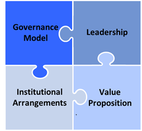
Participating organizations use geospatial data to support a wide range of operational priorities addressing a diversity of issues across a variety of domains. Some federal departments and agencies demonstrate strong capacities in managing geospatial information, with effective leadership in specific areas. Governance of geospatial information in Canada is highly decentralized, causing coordination challenges across regions. The score reflects a perceived need for increased leadership in CGDI matters, potentially in the form of a pan-Canadian geospatial or location data strategy, to offer guidance geospatial data use and production to support Canada’s federal and PT operational priorities.
Strategic Pathway 2: Policy and legal
IGIF Score = 55
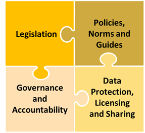
Federal and provincial/territorial laws, policies and arrangements encourage, promote and enable open data, data sharing, data protection and privacy measures, upholding of intellectual property rights (IPR), and protection of liability. However, these legal and policy frameworks are inconsistent and uncoordinated across different levels of government, leading to challenges in data integration and sharing. CCOG acts as a “consultative inter-governmental forum” for federal, provincial and territorial governments to discuss items including proposed legislation, though it excludes private sector, civil society, academia and Indigenous organizations.
Strategic Pathway 3: Financial
IGIF Score = 17.8
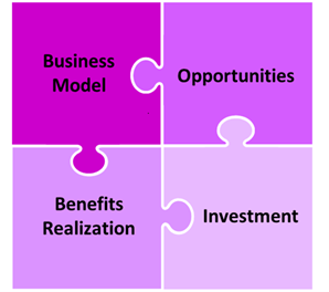
Some departments/agencies have managed to secure adequate funding to maintain their current operations and support ongoing projects. There is positive feedback about program-specific funding, with existing funding appearing to have a good return on investment – particularly for data acquisition. Financial resources for geospatial data management are unevenly distributed and often insufficient for long-term growth and innovation, with a lack of sustainable funding models. Other gaps include a lack of ROI tracking of SDI investment among participating organizations and failure to measure the benefits of SDI implementation or conduct regular socio-economic impact assessments.
Strategic Pathway 4: Data
IGIF Score = 68
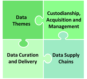
The federal government has established best practices and tools for open government processes, including implementation guidance for policy instruments, which help ensure consistent approaches to open data and information practices across government. Areas of strength included high reported levels of accessibility, findability, interoperability and reusability of foundational data layers, as well as the use of interoperable metadata standards. Although significant efforts have been made in the realm of data acquisition, data flow is hindered by issues with data integration, sharing, and the application of Indigenous data sovereignty principles. Potential gaps include the meeting of foundational data needs of users and in identifying areas of overlap in foundational datasets with Indigenous counterparts.
Strategic Pathway 5: Innovation
IGIF Score = 69.8
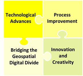
The geospatial sector shows strong potential for innovation through public-private partnerships and academic collaborations that drive the adoption of new technologies. The majority of PT and federal agencies have a geoportal supporting the sharing, viewing, accessing and use of geospatial data. Investment areas include machine learning and artificial intelligence, cloud-based data services, data visualization tools, automated data extraction, and advanced quantitative risk assessment. However, the lack of a comprehensive national strategy for geospatial innovation, bureaucratic hurdles, and insufficient funding limit the broader adoption of emerging technologies.
Strategic Pathway 6: Standards
IGIF Score = 70.3
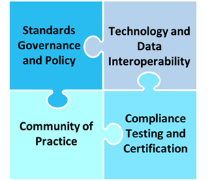
There is broad recognition of the importance of geospatial standards, with certain federal departments and agencies and PTs effectively applying these standards to ensure interoperability. However, in practice, the application and understanding of these standards vary across departments /agencies and governments, leading to inconsistencies that hinder effective geospatial data management. A Standards strategy/plan has been implemented with cross-government and community coordination including an on-going revision. While there is an awareness amongst major stakeholders, no dedicated and active data and standards awareness program is currently in place.
Strategic Pathway 7: Partnerships
IGIF Score = 65.9
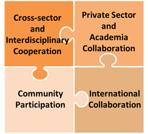
A diversity of partnerships, collaboration and coordination exist between all levels of government, industry members, academia, non-governmental organizations and international partners to advance shared goals and priorities. Regional and international partnerships were identified as areas of strength. Federal and provincial funding supports partnerships to achieve strategic goals (e.g. UN SDGs). However, partnerships across the public sector appear to be managed on an ad hoc basis, with challenges in coordination and duplication of efforts that result in inefficiencies. Potential gaps exist in public-private partnerships promoting new or improved geospatial products and services, in addition to cross-sector interdisciplinary collaborations.
Strategic Pathway 8: Capacity and education
IGIF Score = 46.4
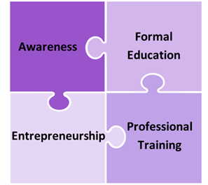
Numerous government initiatives are in place to fund advanced educational programs, professional training and entrepreneurship to build geospatial expertise, particularly within specialized sectors. However, there is a recognized gap in formal education and training programs focused on geospatial information management, leading to a shortage of skilled professionals in the field. There is an absence of publicly available reporting mechanisms on Capacity and Education and associated strategies or action plans.
Strategic Pathway 9: Communication and engagement
IGIF Score = 29.7
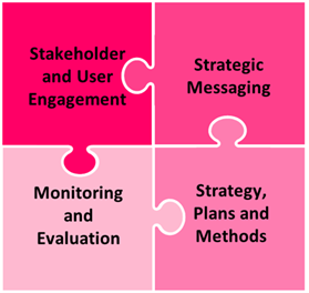
A national user needs assessment for the CGDI was completed within the last five years. No single public communications strategy applies to all types of stakeholders and partners at all government levels, though CCOG and the Geomatics Accord exists as methods for communication and engagement. There are efforts to communicate the value of geospatial information, with certain PTs and federal departments/agencies successfully advocating for the importance of geospatial data. However, communication strategies are perceived to be uncoordinated and often ineffective, with a need for more cohesive and targeted messaging that highlights the economic and societal benefits of geospatial data.
Figure 3 compares trends in IGIF scores across strategic pathways and between stock-take components. Looking at the average scores, the data, innovation, standards and partnerships strategic pathways emerge as areas of relative strength. In the data strategic pathway, this can be attributed to adherence to established best practices for data use and production for accessibility, findability, interoperability and reusability of foundational data layers, as well as the use of interoperable metadata standards. In the innovation strategic pathway, the strong score reflects the widespread use of geoportals supporting the sharing, viewing, accessing and use of geospatial data among federal and PT participants in the CGDI, as well as the strong potential for innovation via public-private partnerships and academic collaborations that drive the adoption of new technologies. In the standards strategic pathway, the strong performance aligns with the broad recognition of the importance of geospatial standards across federal and PT departments and agencies, as well as the implementation of a standards strategy with cross-government and community coordination including an on-going revision. The strong performance in the partnerships strategic pathway reflects the use of partnerships, collaboration and coordination between all levels of government, industry members, academia, non-governmental organizations and international partners to advance shared goals and priorities.
The financial and communication and engagement strategic pathways emerge as areas of relative weakness. The financial result is explained by the uneven distribution of resources for geospatial data management, which are often insufficient for long-term growth and innovation and lack sustainable funding models, as well as the reported lack of financial metric tracking (e.g., ROI tracking of CGDI investment). The low average score for communication and engagement is explained by the absence of a unified communication strategy applying to all types of stakeholders and partners at all government levels, in addition to the reported uncoordinated and ineffective communication strategies currently employed.
Comparing average scores between the three stock-take components, with the exception of the partnerships and policy and legal strategic pathways, the desk study results were scored consistently higher, while the interview results were scored consistently lower. The inventory results are less easily compared, as the inventory questions covered only five of the nine strategic pathways.
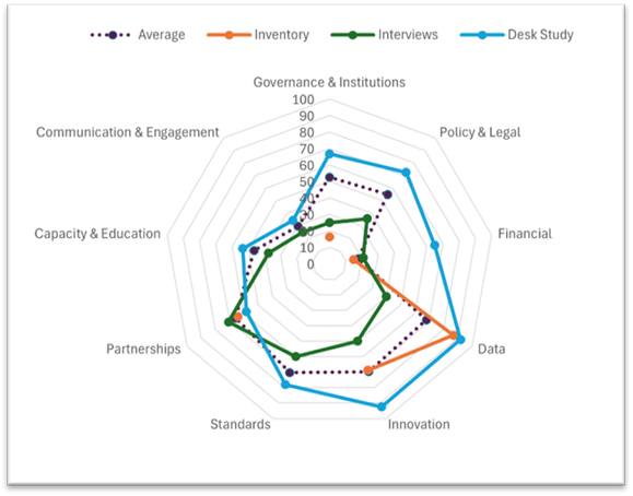
Figure 3. Average scores for each Phase II stock-take component (interviews, inventory, desk study) along each strategic pathway: governance and institutions, policy and legal, financial, data, innovation, standards, partnerships, capacity and training and communication and engagement.
Text description
| Strategic Pathway | Average IGIF Scores For Interviews | Average IGIF Scores for Inventory | Average IGIF Scores for Desk Study | Overall Average IGIF Scores |
| Strategic Pathway 1: Governance & Institutions | 25 | 16.3 | 66.7 | 52.6 |
| Strategic Pathway 2: Policy & Legal | 35.7 | - - - | 72.5 | 55.0 |
| Strategic Pathway 3: Financial | 20.8 | 14.9 | 65 | 17.8 |
| Strategic Pathway 4: Data | 40 | 86.9 | 92 | 68.0 |
| Strategic Pathway 5: Innovation | 50 | 68.8 | 92.5 | 69.8 |
| Strategic Pathway 6: Standards | 60 | - - - | 78.1 | 70.3 |
| Strategic Pathway 7: Partnerships | 70.8 | 64.2 | 58.3 | 65.9 |
| Strategic Pathway 8: Capacity & Education | 37.5 | - - - | 53.5 | 46.4 |
| Strategic Pathway 9: Communication & Engagement | 25 | 16.3 | 34.4 | 29.7 |
5. Key insights and opportunities
5.1 Key insights
The following key insights were unearthed from the results of the stock-take exercise:
- Best practices in data production, use and management: The federal government has established best practices and tools for open government processes, including implementation guidance for policy instruments, which help ensure consistent approaches to open data and information practices across government. This is reflected in reports from federal and PT geospatial data users and producers of high levels of accessibility, findability, interoperability, availability and reusability of foundational data layers. It should be noted that some data users identified gaps in the meeting of their foundational data needs, including financing.
- Decentralized governance: Governance of geospatial information in Canada is highly decentralized, leading to significant coordination challenges. The absence of a centralized governance structure results in uncoordinated efforts across governments.
- Indigenous partnerships and linkages:The stock-take findings suggest an absence of linkages in fundamental datasets produced by participating organizations to Indigenous datasets. In the context of the CGDI, Indigenous data sovereignty is an important consideration that may become foundational to data governance.
- Financial support and ROI tracking: Financial resources for geospatial data management are unevenly distributed and often insufficient for long-term growth and innovation, with a lack of sustainable funding models. The stock-take findings suggest a lack of ROI tracking of CGDI investment among participating organizations and no measurement of the benefits of spatial data infrastructure implementation or conduct regular socio-economic impact assessments.
- Formal education and training gaps: While government initiatives exist to fund advanced educational programs, professional training and entrepreneurship to build geospatial expertise, there is a recognized gap in formal education and training programs focused on geospatial information management, leading to a shortage of skilled professionals in the field.
- Investment in innovation: Identified investment areas include machine learning and artificial intelligence, cloud-based data services, data visualization tools, automated data extraction, and advanced quantitative risk assessment. However, the lack of a comprehensive national strategy for geospatial innovation, bureaucratic hurdles, and insufficient funding limit the broader adoption of emerging technologies.
- Standards application and understanding: There is broad recognition of the importance of geospatial standards, with certain federal departments and agencies and PTs effectively applying these standards to ensure interoperability. However, in practice, the application and understanding of these standards varies, leading to inconsistencies that hinder effective geospatial data management.
5.2 Opportunities
The following opportunities were identified based on the results of the stock-take components (Phase I and Phase II-interviews, inventory, desktop study):
- The need for a Pan-Canadian Geospatial Data Strategy: The development of a pan-Canadian collaborative location data strategy in Canada is widely supported across federal and PT governments. The involvement of various stakeholders and partners, from federal agencies to private industry and Indigenous communities, is viewed as essential for its success.
- Improving data flow: Although significant efforts have been made in the realm of data acquisition, data flow is hindered by issues with data integration, sharing, and the application of Indigenous data sovereignty principles.Reported gaps in foundational data, including financing, may benefit from targeted collaborative solutions.
- Promoting indigenous data sovereignty: An opportunity exists to forge new connections with Indigenous partners to identify areas of overlap in foundational datasets. Successful engagement with Indigenous organizations will be contingent upon respect for Indigenous data sovereignty, defined as the right of Indigenous peoples to govern the collection, use, and sharing of their data.
- Coordinated collaboration with clarified roles and responsibilities: The results demonstrated the use of partnerships, collaboration and coordination between all levels of government, industry members, academia, non-governmental organizations and international partners to advance shared goals and priorities. An opportunity exists to harness this strength to clarify roles and responsibilities within Canada's geospatial ecosystem to support future value creation.
- Building innovation through public-private partnerships: The geospatial sector shows strong potential for innovation through public-private partnerships and academic collaborations that drive the adoption of new technologies.
- Fostering trusting communications and unified engagement: There are efforts to communicate the value of geospatial information, with certain governments and departments/agencies successfully advocating for the importance of geospatial data. However, communication strategies are perceived to be uncoordinated and often ineffective. An opportunity exists to foster engagement through cohesive and targeted messaging that highlights the economic and societal benefits of geospatial data.
- Sustainable investment to promote long-term growth: Financial resources for geospatial data management are unevenly distributed and often insufficient for long-term growth and innovation, with a lack of sustainable funding models. The CGDI would benefit from implementing sustainable funding models with regular ROI assessments to promote growth and innovation.
- Increasing awareness and public education: Gaps in public understanding of the CGDI and geospatial data literacy can be addressed by increasing information available to the public. Fostering public interest in geospatial fields and excitement in the future of the CGDI can help to increase uptake of education and training programs and meet demand for skilled professionals.
6. Limitations
Limitations of the Phase II stock-take components are outlined below.
Interviews
The broader stock-take exercise is informed by the results of a gender-based analysis, which includes an Indigenous engagement component. Nonetheless, one notable limitation of the interview component is that the perspectives of Indigenous organizations, as well as those of other key partners/stakeholders (e.g. private sector, academic, not for profit organizations) – which are being sought in next steps in the data collection process (Phase III) to support strategy development – were not collected in this stage, and thus are not represented in these findings.
Inventory
Some respondents noted the length of their responses to inventory questions was limited by what they could reasonably input within the time set aside to complete their submissions. This may have impacted the completeness or comprehensiveness of some responses. As well, the inventory questions covered only 5 of the 9 strategic pathways from the IGIF framework. For this reason, the results of this component may provide a less fulsome picture of the current state of the CGDI than the other two stock-take components.
Desk study
The desk study provided an external perspective on the current state of the CGDI, which was established drawing from publicly available resources (e.g., government websites, scholarly literature). Per the defined project scope, it was intentionally completed with minimal direction from the stock-take team, and unlike the other two stock-take components, involved no consultation with FPT geospatial experts. This external perspective should be taken into consideration when reviewing the desk study results.
7. Conclusions
This report summarized the results of Phase I and Phase II of the CGDI stock-take exercise, which aimed to scope, socialize and take stock of the current state of the CGDI through publicly available literature and the perspectives of geospatial experts from FPT governments.
The stock-take findings offer insight into the current state of the CGDI. Key takeaways from this exercise include coordination difficulties resulting from decentralized governance, the use of best practices and tools for open government processes, including guidance for policy instrument implementation, and the high levels of accessibility, findability, interoperability, availability, and reusability of foundational data layers produced by federal and PT agencies and organizations. The stock take also highlights the lack of connections between fundamental datasets produced by participating organizations and Indigenous datasets, which could impact the pursuit of Indigenous data sovereignty. Financial support for geospatial data infrastructure is inconsistent, lacking sustainable investment models and ROI tracking, which hinders long-term innovation and socio-economic impact assessment.
Opportunities identified for the CGDI include the creation of a pan-Canadian collaborative location data strategy, widely supported by federal and PT governments. There is also potential to enhance innovation through public-private partnerships and academic collaborations, which would drive the adoption of emerging technologies. These efforts would benefit from sustainable funding models with ongoing ROI assessments to foster growth and innovation. Additionally, current communication challenges can be addressed by fostering unified engagement and developing a cohesive, targeted messaging strategy that highlights the economic and societal benefits of geospatial data and ongoing geospatial initiatives.
The above findings will inform subsequent phases of the stock take, including wider engagement with non-governmental experts aimed at enhancing coordination and collaboration across partners and stakeholders in the CGDI, as well as the development and implementation of a pan-Canadian geospatial data strategy.
Bibliography
Government of Canada. 2014. Directive on Open Government. [accessed 2024 Aug 21]. https://www.tbs-sct.canada.ca/pol/doc-eng.aspx?id=28108.
Hackett J, Olson R. 2019. Dissemination of open geospatial data under the Open Government Licence-Canada through OCAP principles. Report No.: 57e. [accessed 2024 Aug 12]. https://ostrnrcan-dostrncan.canada.ca/handle/1845/144005.
NRCan. 2021. Open Science Action Plan. https://publications.gc.ca/collections/collection_2022/rncan-nrcan/M4-213-2021-eng.pdf.
NRCan. 2022. Stories From the Land: Indigenous place names in Canada. [accessed 2024 Nov 26]. https://natural-resources.canada.ca/simply-science/stories-from-the-land-indigenous-place-names-canada/24409.
NRCan. 2024. Natural Resources Canada 2024-25 Departmental plan. [accessed 2024 Aug 16]. https://natural-resources.canada.ca/transparency/reporting-and-accountability/plans-and-performance-reports/departmental-plan/natural-resources-canada-2024-25-departmental-plan/25624.
NRCan. 2024b. Open Science and Data Platform. [accessed 2024 Nov 25]. https://osdp-psdo.canada.ca/en/about-osdp.
Treasury Board of Canada. 2022. CANADA’S NATIONAL ACTION PLAN ON OPEN GOVERNMENT. https://open.canada.ca/data/dataset/778989e3-f9a2-4a61-92dc-fdf0293cf6ca/resource/b17b6dab-febb-4bca-8328-2bd19220ee96/download/august-2023-updates-to-the-2022-24-national-action-plan-on-open-government_en.pdf.
UN-GGIM. United Nations Integrated Geospatial Information Framework (UN-IGIF). [accessed 2025 April 20]. https://ggim.un.org/UN-IGIF/