
Issue 6, August 2026
On this page:
- Strengthening collaboration
- Indigenous fire and emergency management outreach
- Broadening satellite literacy in wildfire management and education
- WildFireSat contract update
- New publications
- Contact us
- Find out more
Strengthening collaboration
Meeting with government wildland fire management agencies
Overview
The WildFireSat team collaborates with government wildland fire and emergency management organizations through ongoing meetings and engagement activities.
The 2025 WildFireSat Provinces and Territories Workshop took place in Winnipeg, Manitoba, in October 2025, coordinated by the Canadian Interagency Forest Fire Centre (CIFFC). Representatives from provincial and territorial wildland fire management agencies, Parks Canada, the Canadian Association of Fire Chiefs, the Canadian Space Agency, the Department of National Defence, and Public Safety Canada, met with the WildFireSat team to continue ongoing collaboration. A total of 32 participants representing 18 organizations attended the workshop.
In addition to fostering trust and collaboration, the workshop focused on information sharing to support the future adoption of WildFireSat products by helping ensure they are relevant, practical, and usable for wildland fire management agencies across Canada.
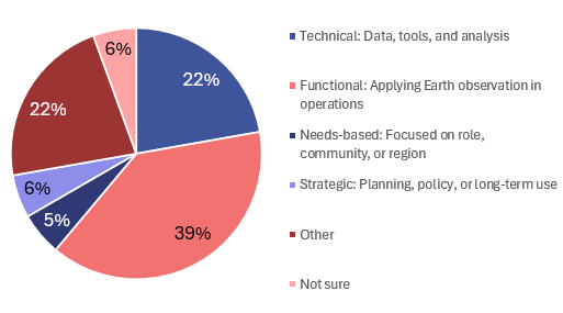
Participants highlighted the need for improved education on satellite data use. During the workshop, participants voted in live polls designed to inform future training development. Microlearning—short, focused lessons—was identified as the preferred training format, especially given the demands of active fire seasons. When asked which type of satellite data training would be the most useful for their organization, participants indicated that functional training (e.g., directly relevant to operational roles, such as incident management) was the highest priority (39%), followed by technical training and other (both 22%) (Figure 1).
Text version
Pie chart showing the percentage of participants that voted for each of the 5 categories of satellite data training: for technical (data, tools, and analysis), 22%; functional (applying Earth observation in operations), 39%; needs-based (focused on role, community, or region), 5%; strategic (planning, policy, or long-term use), 6%; other, 22%; and not sure, 6%.
Note: Results are from a live poll conducted during the workshop. The participants represented 18 organizations.
During the workshop, fire managers highlighted the need for simple, high-level products for time-critical operations, as well as access to more detailed data for deeper analysis when time permits. Following this, the WildFireSat team shared prototype products and discussed their design.
For more details on this session, please see the Constellations in Collaboration workshop proceedings.
Indigenous fire and emergency management outreach
Building relationships with Indigenous organizations
Overview
The WildFireSat team recognizes the important role of Indigenous fire stewardship and is committed to listening, learning, and engaging with Indigenous organizations on the opportunities and challenges the mission presents.
In October 2025, the WildFireSat team and representatives from nine Indigenous fire and emergency management organizations gathered in Winnipeg, Manitoba, on Treaty 1 Territory, the traditional lands of the Anishinabe (Ojibway), Ininew (Cree), Oji-Cree, Dene, and Dakota Peoples, and the homeland of the Métis Nation. The session brought together 12 representatives from across Canada and provided an opportunity for the WildFireSat team to connect with Indigenous fire and emergency management leaders. The gathering was coordinated by the CIFFC and was facilitated by Whitestone Industry Services with support from Natural Resources Canada’s Canadian Forest Service.
The session focused on sharing information about the WildFireSat mission and listening to participants. Discussions explored what is needed to help ensure WildFireSat products are relevant, useful, and trusted. Participants emphasized that collaboration should be grounded in respect, trust, transparency, and recognition of diverse Indigenous knowledge systems and governance structures. Discussions supported reflection on assumptions, roles, expectations, and shared values between all participants. WildFireSat data are more likely to be adopted when aligned with community priorities and Indigenous voices are meaningfully heard.
Participants expressed interest in practical, decision-support products, especially in remote locations. Ease of access, interpretation, and communication within communities was also emphasized.
Text version
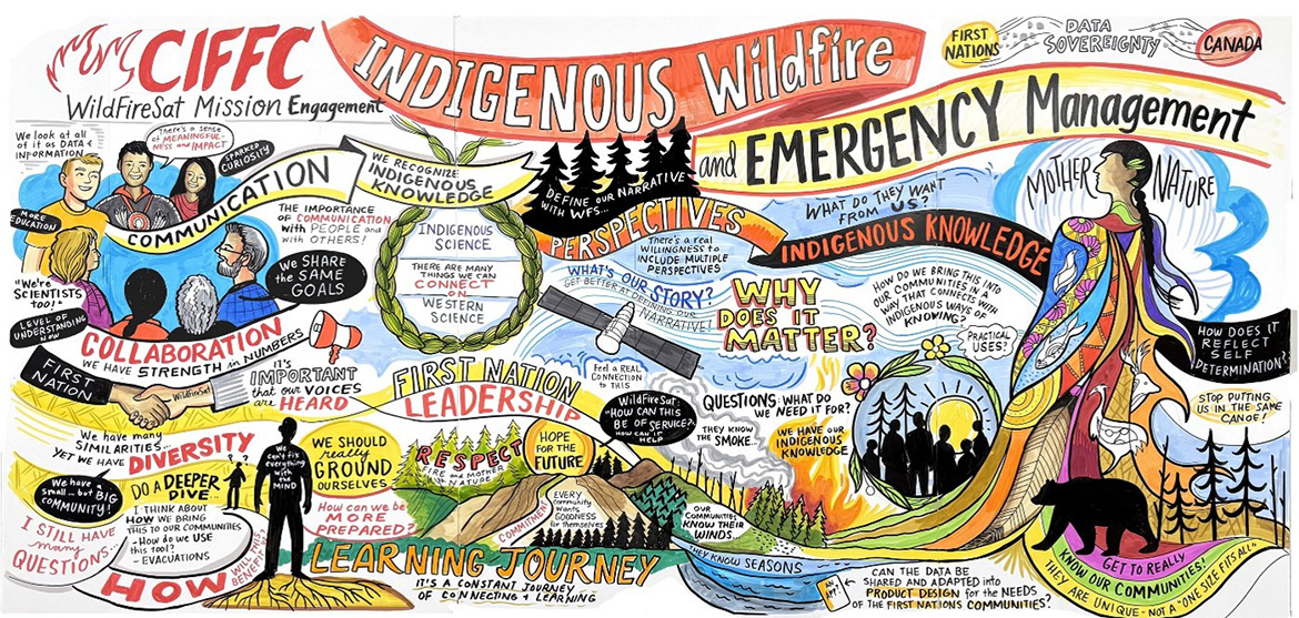
Illustration depicting the title “CIFFC Indigenous Wildfire and Emergency Management” with the following headings: communication, collaboration, perspectives, Indigenous knowledge, First Nation leadership, respect, and learning journey.
The left side shows people in discussion and a handshake between First Nation and the WildFireSat team. In the center, a circular diagram connects Indigenous science and Western science with a satellite overhead and prompts about defining a shared narrative and why it matters. The lower portion depicts mountains, forest, smoke, fire, and notes about preparedness, hope, and communities knowing their lands, seasons, and winds. On the right, a large, illustrated figure labeled “Mother Nature” stands above a forest scene; messages emphasize self-determination, tailoring data products to community needs, and valuing Indigenous ways of knowing.
Note: CIFFC indicates Canadian Interagency Forest Fire Centre.
Participants cautioned against the potential for information overload. The protection of cultural information was also identified as crucial, and there was a strong preference for incorporating WildFireSat data into their own systems.
For more details on this session, please see the Shared Sky and Constellations workshop proceedings.
Broadening satellite literacy in wildland fire management and education
Supporting training and capacity development
Overview
New resources are now available to help increase satellite literacy and support the understanding of how satellites can contribute to wildland fire management in Canada.
The WildFireSat mission aims to build capacity among fire managers. Several recent initiatives have been completed, including a new online training course and a series of educational posters focused on satellite wildland fire applications. Together, these resources aim to improve awareness of how satellite observations support wildland fire detection, monitoring, and decision-making across the wildland fire management cycle.
A new training course, “An Introduction to Satellites in Wildfire Management—Types, Kinds and Uses,” provides an overview of how satellite technology supports wildland fire management in Canada. It introduces Earth observation and the role of satellite data in wildland fire operations. The course is available through the CIFFC Learning Management System, and was developed over 3 years by the WildFireSat team at Natural Resources Canada in collaboration with consultants from thriveGEO; Environment and Climate Change Canada; the CSA; fire agencies from British Columbia, Newfoundland and Labrador, Ontario, and Quebec; and the Provincial Secretariat of Emergencies and Risk Management in Neuquén, Argentina. The course also benefited from materials provided by the United States Department of Agriculture Forest Service Geospatial Management Office, National Aeronautics and Space Administration, National Oceanic and Atmospheric Administration, and the European Space Agency.
Course participants will learn about satellites and their sensors, the types of satellite data available, and how this information can support operational decision-making. Using real-world Canadian examples and interactive modules, the course explores how satellite Earth observation supports the wildland fire management cycle.
The course includes online modules, downloadable resources, and interactive content that allow participants to learn at their own pace. Released under a Creative Commons (CC BY-NC 4.0) license, the training is designed to be free and adaptable for use across the wildland fire community.
e-Learning versions of the course are available in English, French, and Spanish. Downloadable PowerPoint curriculums are available in English, French, Spanish, and Plains Cree. A learning plan to support training delivery is also available in English and French.
To learn more about this training and how satellite remote sensing can support wildland fire operations, visit the course on the new CIFFC Learning Hub.
To complement the training course, a series of educational posters were designed to provide quick-reference guidance on key satellite concepts relevant to wildland fire operations. These materials highlight practical considerations for interpreting and applying satellite information in operational settings.
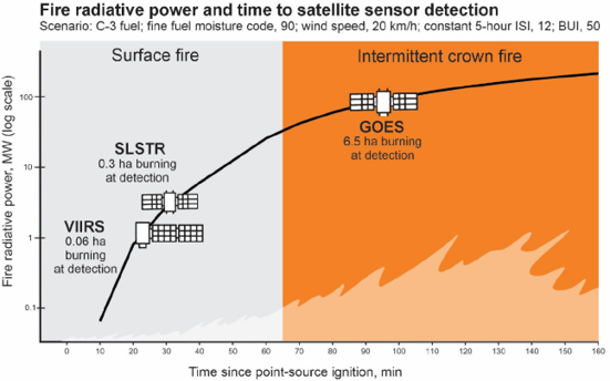
The first poster, “Considerations for Satellite Wildland Fire Detection in Canada,” explores the strengths and limitations of satellite-based fire detection. It explains how factors such as forest canopy cover, satellite spatial resolution, and overpass timing can influence the ability to detect small or low-intensity fires. It also emphasizes that although satellites are valuable for fire monitoring and detection in remote areas, other approaches such as aerial patrols, lookout towers, and public reporting play important roles in many situations.
Text version
The graph has an image overlay depicting a flame growing from low surface fire (shaded grey, 0–< 65 minutes) to high intermittent crown fire (shaded orange, 65–160 minutes). The VIIRS and SLSTR sensors and GOES satellite are illustrated at their respective capabilities. VIIRS, SLSTR, and GOES are illustrated as satellites on an upward trending line indicating the increasing fire radiative power and time since ignition.
Note: BUI indicates Buildup Index; GOES, Geostationary Operational Environmental Satellite; ISI, Initial Spread Index; VIIRS, Visible Infrared Imaging Radiometer Suite; and SLSTR, Sea and Land Surface Temperature Radiometer.
The second poster, “When Will I Get New VIIRS Hotspot Data?,” explains how polar-orbiting satellites pass over Canada at predictable times each day and provides maps showing typical early, average, and late overpass times across the country. Because satellite overpass times are often reported in solar time based on when the satellites cross the equator, they can be difficult for fire managers to translate into local time. This poster helps address that challenge by providing a general range of when users can expect new VIIRS data in their local time zone.

Text version
The map shows that satellite overpass times occur progressively later, moving east across Canada. Each coloured grid cell corresponds to a time zone (each gradient indicates the time range); the darker the colour, the later the time.
Together, these posters help improve satellite literacy by clarifying how satellite observations support wildland fire detection, monitoring, and operational decision-making.
WildFireSat contract update
WildFireSat industry consultation
Overview
On May 22, 2026, the CSA posted a Request for Information (RFI) for the WildFireSat mission, following the termination of an earlier contract.
The CSA is issuing this RFI to gather input for the development of the WildFireSat mission and to assess how Canadian industry can support global operational capability for wildland fire monitoring. On June 2, 2026, the WildFireSat team held a virtual industry information session to provide an overview of the RFI’s objectives, scope, and process, followed by a question-and-answer period. We are inviting Canadian industry stakeholders to share their expertise and help define this important mission. This RFI does not constitute a call for proposals or any contractual commitment. Input received through the RFI will help inform the future direction of the WildFireSat mission and its operational capabilities.
For more information, please visit the WildFireSat Request for Information notice.
New publications
Documenting the science and outreach of the mission
Constellations in collaboration: The 2025 CIFFC WildFireSat and Fire Agency Meeting
This document summarizes the 2025 CIFFC WildFireSat Province and Territory Workshop, held October 21–22 in Winnipeg. The workshop supported ongoing dialogue between the WildFireSat team and wildland fire agencies to ensure products align with user needs and operational requirements.
Shared sky and constellations: The 2025 CIFFC WildFireSat Indigenous Fire and Emergency Management Outreach Session
In October 2025, the CIFFC held an outreach session in Winnipeg with Indigenous wildland fire and emergency management organizations to share information on WildFireSat and gather perspectives. This report summarizes the outcomes.
Considerations for satellite wildland fire detection in Canada
This poster outlines key aspects of satellite-based wildland fire detection in Canada and how it complements other detection methods.
When will I get new VIIRS hotspot data?
This poster shows typical Visible Infrared Imaging Radiometer Suite (VIIRS) sensor overpass times across Canada using historical fire data, along with key considerations for interpreting satellite fire observations.
Contact us
For more information, send an email to wildfiresat-gardefeu@nrcan-rncan.gc.ca. To subscribe to this e-Bulletin, please include “Subscribe me to the WildFireSat e-bulletin” in the subject line of your email.
Find out more
- About WildFireSat (Canadian Space Agency)
- WildFireSat: A Canadian operational mission
- WildFireSat publications
- WildFireSat Remote Sensing Capacity for Use in Fire Management program
- Previous WildFireSat e-Bulletins
- Wildland fire research
- Wildland fire monitoring and reporting tools
A note about third-party information
Information provided by external sources is subject to change at any time. The Government of Canada is not responsible for the accuracy, reliability or timeliness of the information supplied by external sources. If you plan to rely upon this information, you should consult directly with the source of information. Content provided by external sources is not subject to official languages, privacy or accessibility requirements.