
In order to unlock the potential of satellite imagery, users must be able to reliably extract information from the raw data collected by the sensor. Canada Centre for Mapping and Earth Observation (CCMEO) scientists develop the methods needed to transform these raw data into information relevant to the monitoring of Canada’s landmass and natural resources, specifically within the following application areas:
Land Cover and Vegetation
The ability to efficiently and effectively characterize Canada’s vast land mass using remote sensing is fundamental to understanding our natural resources and underpins the strategies for land management aimed at achieving environmental, social and economic sustainability.
Satellite-based land cover classifications assign areas exhibiting different surface cover or type to well-characterized classes (e.g water, bare rock, forest, agriculture, urban) . The more classes, the more detailed the land cover becomes, differentiating one type or forest or scrub land or wetland from multiple others. Land cover can be produced at a various spatial and temporal scales, ranging from infrequent to annual, and from local to expansive.
The Canada Centre for Mapping and Earth Observation (CCMEO) has produced a number of satellite-based national scale and northern land cover products at varying resolution. In partnership with the U.S. and Mexico, CCRS also works within the North American Land Change Monitoring System (NALCMS) to create continental land use change products.
Mapping vegetation and understanding its transformation and health is central to ecosystem studies. CCMEO has used historical satellite datasets to monitor changes in vegetation in Canada’s northern parks (i.e. PARKSPACE) and within studies examining the cumulative effects of environmental change on key indicators, like caribou populations.
For more information on some of the land cover and vegetation products developed at CCMEO, see below links:
Water and Wetlands
Understanding and monitoring Canada’s water is fundamental to the responsible management of this precious resource. Freshwater covers almost 9% of Canada, while wetlands cover an additional 14%.
Earth observation satellites are considered to be the most promising means of monitoring the seasonal changes in both freshwater and the state of wetlands on a regional and national scale. Satellites have also proven effective at characterizing the vegetation and soil characteristics important in the monitoring of Canada’s groundwater.
Scientists at the Canada Centre for Remote Sensing (CCRS) have developed techniques to use satellite Synthetic Aperture Radar (SAR) to map the extent of surface water, to support characterization and monitoring of wetlands and aquifers, and to monitor the transformation of Canada’s peatlands.
Today, new techniques to measure surface water level are being developed and validated using current and future spaceborne SARs, including the RADARSAT Constellation Mission (RCM). Launched in June 2019, the RCM provides daily coverage of Canada, and new data streams are being applied by CCRS scientists to monitor water, wetlands, permafrost, critical infrastructure and natural hazards (i.e., floods, earthquakes, landslides).
Data Collections
Floods in Canada Map Collection
River Ice State in Canada Map Collection
Land Cover of Canada Map Collection
Water and Wetlands Publications
CCRS Emergency Response Activity Internationally
Find out how SAR techniques are being used to map the extent of seasonal flooding and river ice break-up in Canada and abroad.
Geomatics information for the watershed serving Iqaluit, Nunavut, using EO data and ground survey
Read about how satellite data have been combined with surface measurements to identify and manage community water resources in Canada’s North.
Polarimetric RADARSAT-2 for Monitoring Canadian Wetlands
Discover how advanced SAR-based techniques are being developed and used to help characterize wetlands.These techniques are being further developed to measure the transformation of Canada’s peatlands with current and future SAR satellites.
Permafrost, Ice and Snow
Satellites offer a unique and valuable perspective on Canada’s extensive cryosphere. Within the Canada Centre for Mapping and Earth Observation (CCMEO), methods capable of monitoring the seasonal and geographical variability of lake and river ice, permafrost and snow are actively being developed.
Techniques developed at CCMEO are now being used across Canada to monitor the timing and related dynamics of lake and river ice freeze-up and break-up. This information supports the safe use of seasonal ice roads, improves flood and weather prediction and secures nearby infrastructure.
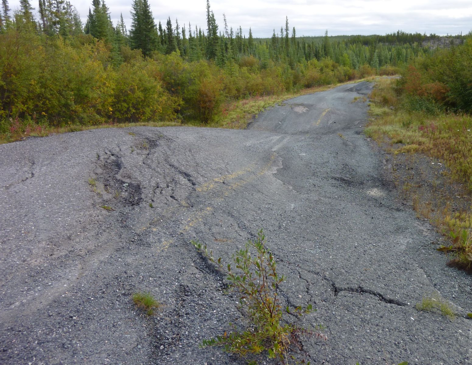
Text Version - Figure 1
A deformed, abandoned highway near Yellowknife in Northwest Territories. The construction and maintenance of infrastructure in Canada’s North (e.g. roads, pipelines) must contend with the surface deformation related to the seasonal freeze and thaw of permafrost. This thawing may trigger landslides that affect energy transportation corridors and adjacent watersheds, as illustrated in this aerial photograph taken near Fort McPherson, NWT. Photo by R. Fraser, NRCan. # 2014-038
Mapping and Monitoring Lake Ice using SAR Satellites PDF, KB
In Canada’s North, people reside, work and travel on terrain often underlain by frozen soil or permafrost. The seasonal freeze and thaw of the surface active layer leads to subsidence and heave, which represents a significant challenge to the design and maintenance of northern infrastructure. CCMEO scientists are developing methods to use satellite SAR data to measure the stability of terrain in Canada’s permafrost zones.
InSAR Measurements of Terrain Stability in Canada's North PDF, KB
CCMEO has also developed techniques to monitor snow cover extent and properties from visible/infrared satellites. Information on snow cover extent is required for climate and weather models, water quantity modelling, estimating hydroelectricity potential, water quality and flood forecast models, crop and forest management including drought and forest fire danger assessments, habitat suitability assessments, transportation planning, and tourism.
Resource Development
Remote sensing science has a central role to play in the responsible development of Canada’s natural resources during their discovery, development, regulation, production and remediation.
Scientists at the Canada Centre for Remote Sensing (CCRS) are developing methods of harnessing these spaceborne observations to help ensure resource development is done in a safe, sustainable way across Canada, including monitoring:
- Land cover and infrastructure change
- Water and wetland transformation
- Permafrost, river ice and snow dynamics
- Ground subsidence and heave related to mining activities
In Canada’s North, infrastructure important to resource development (e.g., highways, ice roads, buildings) are particularly vulnerable to the seasonal melt of freshwater ice,including permafrost, which is further accelerated today due to the warming of Canada’s Arctic. Working with the Geological Survey of Canada, CCRS scientists are developing methods using Synthetic Aperture Radar (SAR) to measure permafrost-related terrain stability near critical infrastructure.
Infrastructure and Resource Development Publications
InSAR Measurements of Terrain Stability in Canada's North
Find out more about techniques developed at CCRS to monitor terrain stability, permafrost activity and critical infrastructure.
Hyperspectral Data for Arctic Geology and Mineral Resources
Contaminated Site Remediation Monitoring
Read about research focused on the potential for hyperspectral data to support the discovery of minerals in Canada’s north and in the remediation of contaminated mine sites.
Natural Hazards
Natural hazards have the potential to be serious threats to the well-being of Canadians. The outcome can be catastrophic, often resulting in damage to critical infrastructure and the environment, injury to humans, and even loss of life.
Scientists at the Canada Centre for Remote Sensing (CCRS) have been developing remote sensing science techniques using satellite data to better understand, map and monitor natural hazards such as landslides, floods and river ice break-up, with the goal of enhancing the safety and security of Canadians.
Scientists are working with satellite interferometric Synthetic Aperture Radar, or satellite InSAR, to measure slope movement and terrain stability on the order of millimetres (Figure 1).
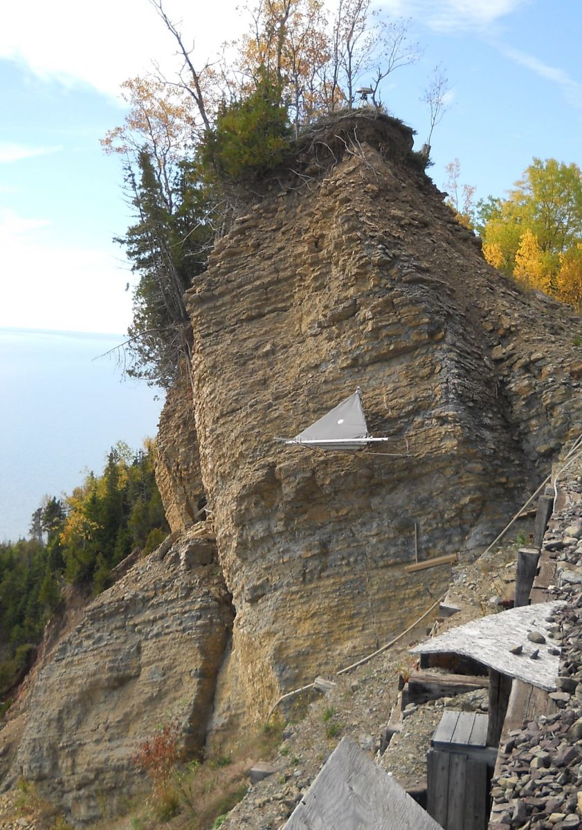
Text Version - Figure 1
Radar target installed on a hazardous slope in eastern Canada. Space-borne radar satellites, like Canada’s RADARSAT-2, precisely measure small changes in the movement of artificial radar targets like these to monitor the stability of slopes, and the deformation of the surface due to natural processes (e.g. permafrost melt) and human activities (e.g. mining). Photo by C. Prévost, NRCan. #2014-040
Since 2006, CCRS’ Emergency Geomatics Service (EGS) has been using satellite SAR imagery to derive near-real time, synoptic flood extent products during seasonal floods and river ice break-up. These products provide emergency responders at a range of levels and jurisdictions with critical information required for emergency response.
Canada’s RADARSAT Constellation Mission launched in June 2019, and the European Space Agency’s Sentinel-1, will enable more frequent and improved monitoring of ground movement, landslide areas, river ice break-up and floods.
Data Collections
Floods in Canada Map Collection
River Ice State in Canada Map Collection
Natural Hazards Publications
InSAR monitoring of permafrost activity, NWT, Canada
Find out more about techniques developed at CCRS to monitor permafrost activity and critical infrastructure.
CCRS Emergency Response Activities Internationally
Find out how SAR techniques are being used to map the extent of seasonal flooding and river ice break-up.
In partnership with the Canadian Space Agency and other government users, CCMEO scientists work to understand the relationship between the signals measured by satellite sensors and the physical characteristics of the Earth’s surface. After development and validation, these techniques are often adopted by industry, government and academia to support their regular use of satellite imagery.
- Characterization and Monitoring Change of Canada’s Land Surface
- Floods and River Ice Break-up
- Educational Resources:
- Articles, Videos and Podcasts:
- Monitoring Centimetre Movements from Space (Byte-Sized Science)
- Mapping a Flood: every minute counts
- Prototype flood map app captures what satellites can’t
- Using Satellites to Monitor Floods (Natural Elements)
- Flood Monitoring using Satellite Imagery (Science at Work)
- Canada as Never Seen Before: the RADARSAT Constellation Mission