The Canadian Model for Peatlands (CaMP)

Overview
Peatlands are dominant features of the Canadian landscape. Their importance to the global carbon balance has been recognized for decades as has their sensitivity to and potential role in intensifying climate change.
The vulnerability of Canada’s large peatland carbon stocks to the effects of climate change concerns Canada’s federal, provincial, and territorial governments. The potential for climate change feedbacks from Canadian boreal forests and peatland systems is of interest to the international scientific and policy communities.
In addition to the need for a better understanding of the net GHG balance from peatlands at a national level, there are also knowledge gaps around the impacts of human activities on the peatland carbon balance. However, estimates of peatland carbon stocks and their greenhouse gas (GHG) emissions and removals remain highly uncertain.
The Canadian Model for Peatlands (CaMP) is a computer model framework for national GHG emissions and removals estimation and reporting for peatlands that runs as a module in the Generic Carbon budget Model (GCBM). Peatlands can be large sinks for carbon dioxide (CO2), but they can also be a significant source of methane (CH4). The ability to calculate the balance between the uptake and emission of these two major GHGs is vital.
Status of CaMP
CaMP is fully coded, calibrated and evaluated against reported values for forest carbon emission factors. Several landscape-level trials have been performed and the first broad-scale assessment across 63.9 million hectares of peatlands within the boreal and temperate ecozones has been undertaken. Next steps include:
- modelling climate change and fire regime shift scenarios
- including soil temperature and permafrost
- accounting for lateral flows of dissolved carbon
- adding sub-annual time steps to better reflect winter emissions
- developing a disturbance matrices database to include additional anthropogenic disturbances and Indigenous knowledge
About CaMP
In 2014, a team of researchers with expertise in peatland ecology, fire, soils, and carbon accounting developed the Canadian Model for Peatlands (CaMP) framework.
5 key development steps:
- Identifying and mapping key peatland categories
- Curating databases of peatland productivity and decomposition parameters and peat chemistry
- Synthesizing reported values of peatland emissions
- Creating the model
- Developing disturbance matrices for anthropogenic disturbances
1. Identifying and mapping key peatland categories
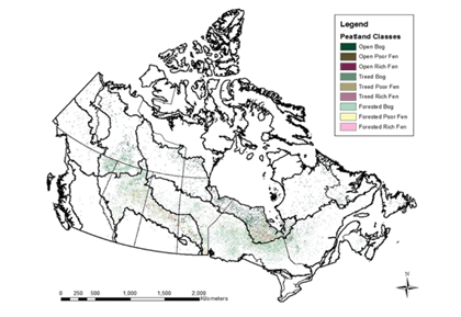
The distribution of peatland types was a fundamental spatial input for modelling carbon emissions and removals at a national scale. The categories had to reflect distinct carbon cycling dynamics within peatlands.

The 11 peatland categories identified included:
- forested, treed and open bog
- forested, treed and open poor fen
- forested, treed and open rich fen
- forested, treed swamp
Nine categories (bogs, poor fens, and rich fens only) were mapped at a national scale by combining a previously published forested peatland map with a previously published map of open peatlands. This key spatial layer will be refined as wetland mapping technology and methodology improves.
2. Curating databases of peatland productivity and decomposition parameters and chemistry
The model requires estimates of vegetation, litter, and soil properties across peatland types in different ecoregions. Two databases were compiled, including a peatland productivity and decomposition database (Net Primary Productivity, biomass, and litter decay) and a peat profile database.
3. Synthesizing reported values of peatland emissions
The development and testing of the CaMP required empirical field data to assess model accuracy. Net Ecosystem Exchange and methane emissions values from Canadian studies were summarized on daily, seasonal, and annual bases for the major ecoregions in Canada containing peatland.
4. Creating the model
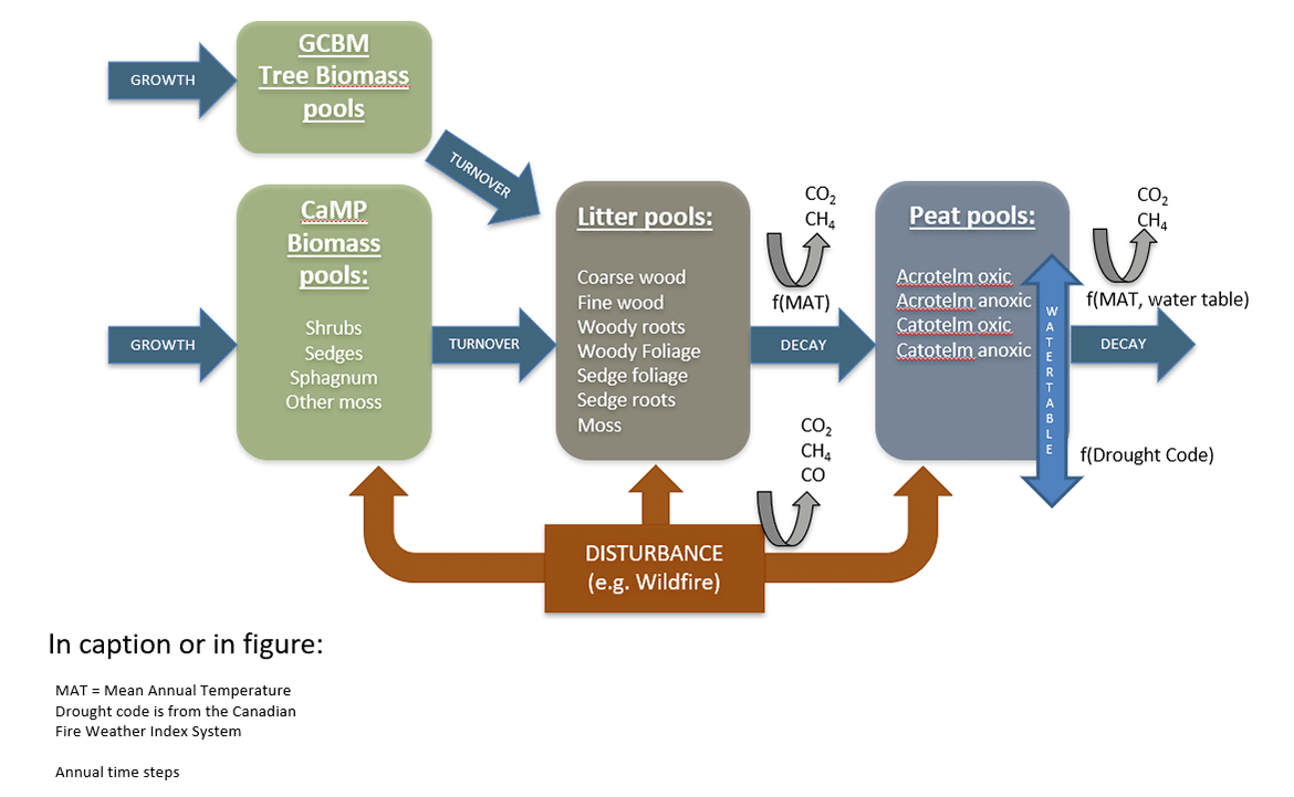
The CaMP model runs as a module within the Generic Carbon Budget Model (GCBM) at an annual time step. CaMP can be applied to the 11 different peatland categories and tracks the growth, turnover and decay in annual time steps of various vegetation components of trees, shrubs, sedges and mosses, and litter and peat pools. The peat pool is separated into acrotelm and catotelm based on simulated long-term water table. Annual changes in the water table are an important driver of carbon emissions from peatlands and the CaMP uses drought code to simulate its annual average depth. Methane is a key gas generated in saturated peatland soils and it is modelled as a function of deviation of water table depth from peak methane production depth developed for different peatland types. Fire disturbance impacts on biomass, litter and peat pools are calculated using fire disturbance matrices and reflect carbon transfers from peat resulting from wildfire derived from field data and expert knowledge. The area of peatlands burned is taken from the National Burned Area Composite spatial layer.

Text version
The diagram is divided into four main boxes representing different "pools" of biomass or organic matter:
- GCBM tree biomass pools (green box): Refers to biomass from trees.
- CaMP biomass pools (light green box): Represents biomass from smaller plants such as shrubs, sedges, and mosses
- Litter pools (dark brown box): Contains coarse and fine wood, leaf litter, roots, moss, and other decomposed material.
- Peat pools (dark blue box): Divided into specific categories like "acrotelm oxic," "acrotelm anoxic," "catotelm oxic," and "catotelm anoxic," which refer to layers in a peatland (oxic = oxygenated, anoxic = without oxygen).
Processes:
- Growth (blue arrows): Biomass pools (tree and plant biomass) grow and contribute to the litter pool.
- Turnover (blue arrow): Biomass, over time, moves to the litter pools as plants and trees shed leaves, wood, and other material.
- Decay (curved black arrows): Organic material in the litter pools and peat pools undergoes decomposition.
- Disturbance (orange arrows): Wildfires directly impact all pools, converting biomass and litter into different forms of material or releasing it as gas into the atmosphere.
Key Dynamics:
- Litter pools as a transition zone: Litter pools act as intermediates, receiving input from tree and plant biomass (via turnover) and transferring decomposed material into peat pools.
- Peat pools for long-term storage: Peat pools are specialized for long-term carbon storage, with distinct layers that decompose at different rates depending on oxygen availability.
- Feedback loops (curved black arrows): The CaMP model runs as a module within the Generic Carbon Budget Model (GCBM) at an annual time step.
5. Developing disturbance matrices for anthropogenic disturbances
Peatlands experience different types of human disturbance including forest harvesting within peatlands, in-situ oil sands disturbance and other linear disturbances related to oil and gas exploration and hydroelectric transmission lines. The development of disturbance matrices for these impacts is ongoing.
For more information about CaMP, contact Kara Webster.
Find out more
Canadian Forest Service Publications
- The Canadian model for peatlands (CaMP): A peatland carbon model for national greenhouse gas reporting (2020)
- A wetland data base for the western boreal, subarctic, and arctic regions of Canada (2000)
- A peatland productivity and decomposition parameter database (2018)
- Spatially-integrated estimates of net ecosystem exchange and methane fluxes from Canadian peatlands (2018)
- Canadian Model for Peatlands Version 1.0: a model design document (2016)
Related information
Page details
- Date modified: