
See the Arctic in a new way with a fresh, detailed look at its northern ecosystems
September 2026
Simply Science for Natural Resources Canada
Until now, only a small fraction of the Arctic’s wetlands had been documented in detail. Natural Resources Canada scientists have created an up-to-date picture of water-rich ecosystems circling the North Pole, and they’ve done it from a whole new angle. By rotating the conventional view to reflect a true circumpolar perspective, the project invites people to see the Arctic not as a distant frontier at the northern edge of our maps, but as the centre of a shared, multinational region viewed from directly above.
More than a Canadian view
The map is the first of its kind, providing a detailed inventory of coastal wetlands and wetland ecosystem types — bogs, fens, swamps and marshes — across the Arctic. It’s the product of years of science diplomacy and international collaboration, reflecting a growing commitment to sustainable development in the North.
“This isn’t just a Canadian view of the Arctic — it’s a circumpolar view,” says Graham Wilkes, a geographer with the Canada Centre for Mapping and Earth Observation, which helps build the Canadian Geospatial Data Infrastructure. “It shows what the region looks like from above and reminds us that what happens here affects all of us.”
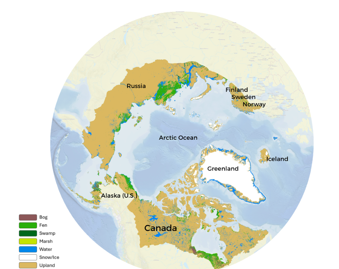
The Arctic wetlands map. A northern view of the Arctic reveals wetlands stretching across borders and connecting northern regions. Background imagery courtesy of Arctic SDI.
Supporting local interests — now and in the future
More than a scientific achievement, the new Arctic wetlands map is a practical tool for anyone working in these northern regions. It provides foundational data to support everything from environmental monitoring and habitat protection to sustainable economic development.
With Arctic activity expected to grow in the coming decades, datasets like this are essential for responsible planning. They can help ensure that development related to mining, fisheries or infrastructure is carried out in an informed, environmentally sound and equitable way. Most importantly, the map supports decision-making that includes and benefits local communities.
“There will be future development in the Arctic,” says Graham. “This data helps provide the information needed so it’s done sustainably, equitably and in close partnership with local communities and Indigenous Peoples, who are most directly affected.”
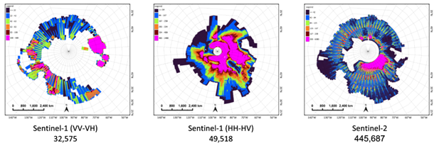
The team used satellite images from the Sentinel missions to map Arctic wetlands. The composite maps above show where the images were collected and how many were used to classify different areas — more than 500,000 in all.
The science behind the map
Creating a pan-Arctic wetlands dataset is no small feat. The region covers thousands of kilometres of remote tundra and is far too vast for traditional field surveys. To address these challenges, Graham and his colleagues turned to what they know best: earth observation from above, supported by a cloud-based digital platform.
“We relied on satellite imagery, cloud computing, interoperable standards and machine learning — driven by a spirit of innovation — to do what would otherwise have been impossible,” says Graham. “It’s a great example of Canada’s strengths in remote sensing.”
Highlights of the process:
- More than 500 terabytes of satellite imagery were processed using cloud-computing platforms. That’s equivalent to more than 50 million high-resolution photos or 130,000 hours of HD video.
- Artificial intelligence (AI), including machine learning, was used to classify wetland types according to the Canadian Wetland Classification System, developed by the National Wetlands Working Group and used by Environment and Climate Change Canada.
- The project drew on infrastructure and expertise from C-CORE, a research organization based in Newfoundland and Labrador, together with input from wetland experts from across Arctic nations.
“We used to do this kind of work by hand. With researchers out in the field, identifying wetlands visually,” says Graham. “But at this scale, you need new tools. The result is incredibly detailed and cost-effective.”
International collaboration and Arctic diplomacy
This map was made possible by years of crucial international co-operation among national mapping agencies, expert wetland groups and the Conservation of Arctic Flora and Fauna (CAFF), the Arctic Council’s biodiversity working group.
“We’ve been working on this for years through Arctic collaboration,” says Graham. “This wetlands map was one of CAFF’s top data priorities. Scientists and data experts came together to address a gap in our understanding of the North and support the needs of Indigenous communities.”
The product was developed to directly support CAFF, which focuses on conserving Arctic biodiversity. Once completed, the dataset was added to CAFF’s Arctic Biodiversity Data Service, an online platform where scientists and decision-makers can access and share Arctic biodiversity-related data, maps and graphics.
“We leveraged modern spatial data infrastructure and the geospatial standards of the the Canadian Geospatial Data Infrastructure,” says Graham. “This modern infrastructure, combined with AI tools and expertise, allowed us to deliver a product that’s reliable, compatible and ready for rapid use across the Arctic.”
Canada led the effort on the new map, but other Arctic nations also contributed test data and validation samples to help train and verify AI models. This collaboration allowed researchers to align their efforts with biodiversity and environmental monitoring goals. Coordination with national mapping agencies and expert groups also helped ensure the data would be useful not just for Canadians, but for communities and governments across the Arctic.
“It takes more than a village — it takes a whole circumpolar community,” says Graham. “This is science diplomacy in action.”
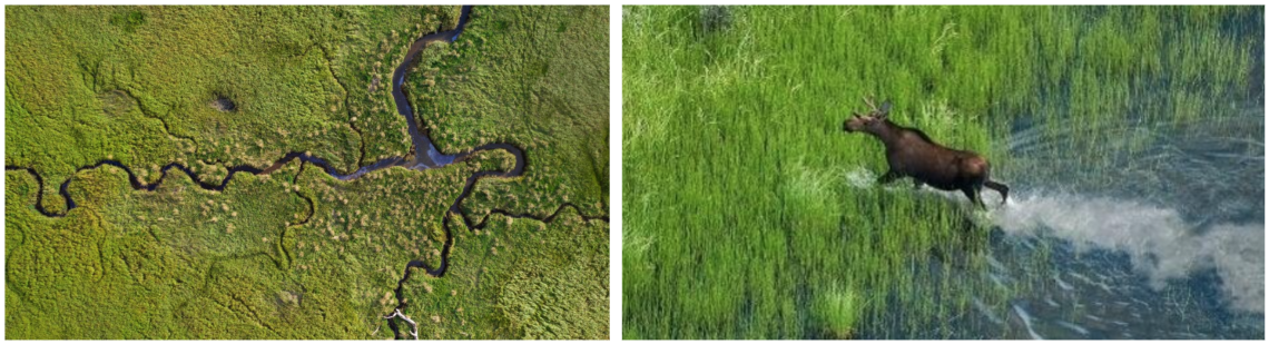
From remote marshes to wildlife corridors, Arctic wetlands are essential ecosystems that store carbon, support biodiversity and protect northern communities.
The significance of wetlands
Arctic wetlands are vital ecosystems that provide far-reaching benefits. They help regulate the environment by improving water quality, reducing flooding and recharging groundwater. They act as natural carbon sinks, storing carbon that might otherwise enter the atmosphere, and they buffer shorelines from erosion. Wetlands are also rich in biodiversity, providing critical habitat for migratory birds and other wildlife.
For Indigenous Peoples, wetlands hold deep cultural, ecological and economic significance, supporting traditional practices such as hunting and harvesting.
For all these reasons, and as the climate continues to shift, protecting these wetlands has become even more crucial — not just for the North, but for the planet as a whole.
“Wetlands are powerful carbon sinks, biodiversity hotspots and climate regulators,” says Graham. “In the Arctic, they’re on the front lines of climate change.”
A baseline for future change
This new wetlands map is just the beginning. It sets the stage for future projects that can track change over time by detecting shifts in wetland extent, health and function as the Arctic warms.
“We’re creating baselines for monitoring,” says Graham. “With this approach, we can track how Arctic wetlands change over years and decades.”
The project also helps advance Canada’s geomatics and earth observation sector by:
- developing new AI-based classification methods
- supporting geospatial jobs and innovation
- strengthening Canada’s international leadership in Arctic science
“This is the future of science: advanced algorithms, big data and international cooperation,” says Graham. “It shows what’s possible when we work together.”
A new way of seeing the Arctic
Canada’s Arctic wetlands map may look straightforward, but the story of its creation and the new perspective it provides, is more complex. Its development required diplomacy, science and technical innovation. By placing the Arctic front and centre, this groundbreaking achievement offers a new way to see and understand one of the world’s most sensitive and significant regions.
This work builds on methods developed by the late Brian Brisco, PhD, and his colleagues, whose contributions to Earth observation science at NRCan continue to guide mapping science today.
Explore more:
Canada Centre for Mapping and Earth Observation
Canada’s Spatial Data Infrastructure
Arctic Spatial Data Infrastructure (Arctic SDI)
Arctic Science