
Did you know that Canada is home to potentially active volcanoes? In the shadow of these seemingly sleeping giants lie powerful reminders of Canada’s volcanic past and important insights into possible future eruptions. Scientists can now closely monitor these dormant volcanoes and help to mitigate potential risks.
April 2024
By Mélanie Lussier
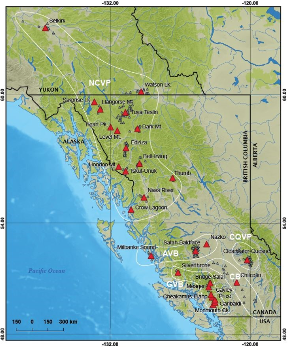
Canadian volcanoes that have erupted in the last 1.8 million years. Red triangles are volcanic complexes or fields whose threat has been assessed; the smaller grey triangles are individual volcanic vents that form part of a volcanic complex.
Canada’s 28 volcanic fields are all in British Columbia and the Yukon, but the impacts of an eruption can range far and wide. Volcanic ash, in particular, poses significant risks with its potential to travel thousands of kilometres. The ash can seriously damage aircraft, affect crops, clog ventilation systems and bring ground transportation to a halt. Such disruptions can impact air traffic and supply chains, leading to broader economic impacts.
More immediately, lava flows and lahars — the mudflow of rocky debris and water — can have disastrous impacts on people who live near the volcano. For example, Nisga’a First Nation oral histories record that the eruption of Sii Aks / Tseax cone in northwestern British Columbia in the mid-1700s killed about to 2,000 people and produced valley-filling lava flows that destroyed several villages.
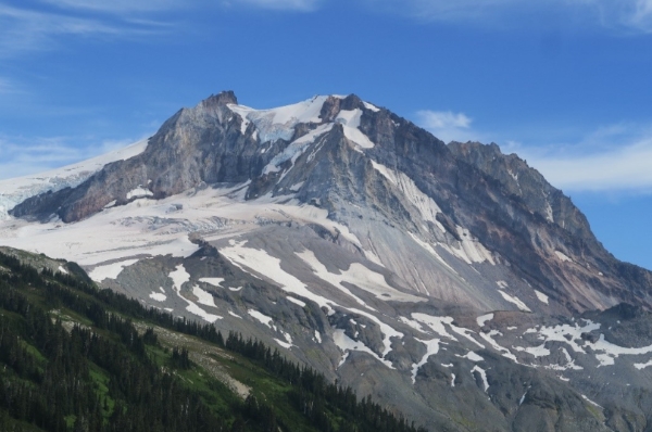
The unstable volcano Nch’ḵay / Mount Garibaldi in British Columbia, as seen from the north..
To discover more about how we can reduce volcano hazards, Simply Science talked with Earth Observation scientist Drew Rotheram-Clarke and volcanologists Melanie Kelman and Yannick Le Moigne from the Geological Survey of Canada (GSC).
"The good thing is that we can make hazard and risk assessments and reduce that risk through monitoring," explains Melanie. "These assessments can tell us what volcanic hazards may affect specific areas and allow us to evaluate possible effects on people and property, while monitoring seismic activity and other phenomena can help us forecast what may happen. All this can be used to devise mitigation strategies."
Short-term mitigation actions taken before and during a volcanic event include evacuating people, relocating vehicles and aircraft, cleaning up volcanic ash — especially from roofs — and shielding machinery from ash.
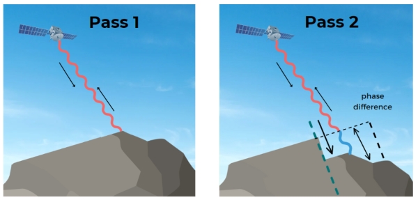
By comparing two radar images of the same area taken at different times, InSAR can detect even subtle changes in the Earth’s surface, such as subsidence, uplift and horizontal motion.
That was then, this is now
As part of the ongoing Volcano Risk Reduction in Canada project, GSC scientists are gaining insights into our volcanoes through interferometric synthetic aperture radar (InSAR) technology, a remote sensing technique that uses radar waves emitted by satellites to precisely measure deformations in the ground surface.
Scientists once relied on instruments physically placed on the ground to monitor volcano deformation. They still use this method, but now combine it with InSAR and other remote sensing techniques to get the fullest possible detailed picture of the changes.
InSAR also allows scientists to collect measurements over hundreds of square kilometres frequently and at a very low cost and has many other advantages.
"Something that we can do with InSAR that we couldn’t do before is detect and measure if a remote and inaccessible volcano is changing in shape," Melanie says. This new ability is significant since even changes as small as a few millimetres could mean a volcano is deforming due to magmatic displacement, which is one of the conditions that point to an eruption.
"We have this routine monitoring in place that can be done fully remotely," Drew adds. "It’s very cost-effective. InSAR is kind of the early detection mechanism, and then once we detect that a volcanic site is in a state of unrest, we can proceed more justifiably with other, ground-based monitoring".
"InSAR monitoring can’t detect all volcanic unrest, because not all volcanoes deform before eruption. However, using it greatly increases our situational awareness of the dormancy or unrest status of our volcanoes."
Using InSAR in combination with other technologies, the GSC is now building a database of imagery for all high, and very high-threat volcanoes in Canada.
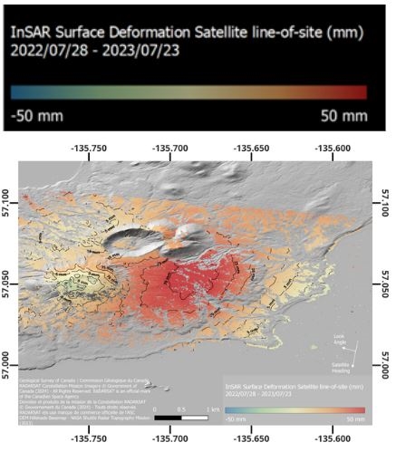
Ground displacement as measured by InSAR between July 28, 2022, to July 23, 2023. Ground uplift is shown in red and subsidence in blue. This map shows the accumulated surface deformation that occurred over a period of approximately one year at Mt. Edgecumbe, a volcano about 200 km west of the Alaska–B.C. border. After about 800 years with no evidence of activity or unrest, this volcano began to inflate at a rate of approximately 7 cm per year starting in 2018 before slowing to 2–3 cm per year. This fluctuation is believed to have been caused by a recharging magma chamber 10 km below the volcano vent.
Field scientists are still needed!
While InSAR can look at volcanoes across the country, our three volcanology experts point out that it will never replace boots on the ground. To make thorough assessments, scientists still need to go on location to conduct geologic mapping, collect samples for analysis and perform ground-based monitoring of earthquakes, ground deformation, gas emissions and other volcanic phenomena.
"InSAR is really great because it gives you an idea of whether the magma below the volcano is moving or not," Yannick says. "But to know what kind of magma is moving, you need to go in the field and get the history of the volcano. We need to merge remote sensing observations — which we do with InSAR — with ground observations so we can understand what is happening much better."
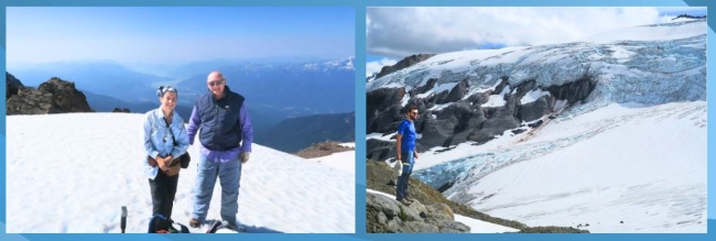
Left: Melanie Kelman and Kelly Russell of University of B.C. on Dalton Dome near the summit of Nch’ḵay ̓/ Mount Garibaldi during 2022 mapping. Right: Yannick Le Moigne during summer 2022 field mapping, looking southward from the Glacier Pikes volcanic centre, which is located to the east of Nch’ḵay̓ / Mount Garibaldi.
Learning with InSAR
The InSAR team has been routinely monitoring nine volcanic sites in British Columbia. They’ve observed many signs of surface deformation, including glacier movements and creeping landslides. But these events are all non-magmatic, and there is no evidence from InSAR that any of Canada’s volcanoes are currently deforming from magmatic processes.
Yet the InSAR evidence to date is of value in that it confirms the findings of other studies, namely that Nch’ḵay̓ / Mount Garibaldi and Qw’elqw’elústen / Mount Meager are big, structurally unstable volcanoes that have a lot of landslides and frequent ground deformation.
"The more data we collect, the better we’re going to understand what ‘normal’ looks like for each volcano," says Melanie. "We need to build a baseline of how the volcano behaves when it’s not restless. This will help us detect when there are magmatic unrest anomalies."
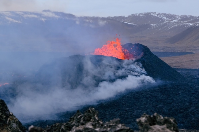
Volcanic eruption on the Reykjanes Peninsula in Iceland on April 10, 2024. Photo: Jón Bjarni Friðriksson/Icelandic Meteorological Office.
Lessons from Iceland
Recognizing the importance of learning about our own volcanoes through international observations, the GSC team looks beyond Canadian borders to validate their methodologies.
"There has never been an eruption on the Canadian landmass in living memory, so it’s really hard for us to study eruption dynamics,” Drew says.
"Studying examples of magmatic deformation globally, both in near real-time and retrospectively, teaches us what to look for and how to look for it, and what techniques might work or might be problematic for us when monitoring unrest on our own soil."
.png)
Conceptual block diagram showing a proposed magma domain where magma accumulated for several weeks before feeding a rapidly propagating lateral dike and surface eruptive fissures on February 8, 2024. The co-eruptive InSAR data is overlayed showing the surface deformation signal between February 6 – 10, 2024. This deformation was a direct result of changes in subsurface magma volume of both the magma chamber and the new intrusive dike. Adapted from Freysteinn Sigmundsson et al (2024).
For example, the team monitored recent eruptions on Iceland’s Reykjanes peninsula with new measurements on a near-daily basis using satellite images from the RADARSAT Constellation Mission. They precisely measured the surface deformation before, during and after recent eruptions; observed dyke formation; and imaged the lava flow footprint. This entire process occurred in near real-time, with new measurements of the surface in some instances generated within an hour of the satellite passing over the area.
Understanding volcanic activity around the world is of great importance. “If and when an unrest event occurs in Canada,” says Drew, “it will very likely be the first eruption that Canadian volcanologists will have ever dealt with. We can draw on the expertise of other scientists globally who have experience in managing unrest and volcanic eruptions.”
What’s next for the GSC volcanologists?
Volcano research is a dynamic field with many exciting developments.
NRCan’s Canadian Hazards Information Service plans to conduct its InSAR monitoring permanently, providing a continuous data stream for Canadian volcanoes. “This will enhance our situational awareness and capacity for other types of volcano monitoring,” Melanie says. NRCan is also currently developing a hazard and risk assessment for Nch’ḵay̓ / Mount Garibaldi and hopes to do the same for other Canadian volcanoes.
Beyond InSAR, researchers are exploring other innovative technologies. “We collected a lot of images of the Nch’ḵay̓/Mt. Garibald volcano from a helicopter,” Yannick says, and these images were used to build a 3D model of the volcano.
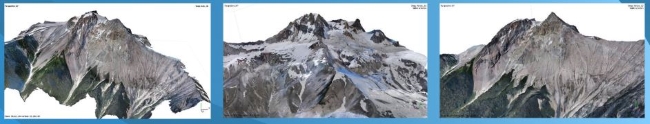
3D photogrammetry models constructed from more than 10,500 overlapping images by Simon Fraser University student Sarai Montañez Muñoz.
"Now we have someone who is working with us from Simon Fraser University to produce very beautiful models,” says Yannick. “This allows us to look at all the small features of the volcano, the different layers of lava flows, pyroclastic flow deposits and so on from the comfort of our office."
The GSC also plans on venturing into the realm of artificial intelligence (AI).
“We’ve been working with the Canadian Space Agency to develop a global volcano watch mission,” says Drew. “With InSAR enabling the generation of hundreds of thousands of observations globally, we could train a machine-learning model to automate the detection of volcanic unrest.”
In these ways and other, the GSC’s commitment to advancing volcano research through technology and international collaboration ensures a deeper understanding of Canada’s volcanic landscape and can help us prepare for potential volcanic events.
Explore:
What are the special hazards from volcanic ash?
Harnessing the power of volcanoes (Simply Science article)