
With scientists predicting major water shortages in less than 10 years, we need to make smart choices today about how to use and protect our water resources. The Canada1Water project aims to help. Co-led by Natural Resources Canada’s Groundwater Geoscience Program and Aquanty Inc., it will give Canadians powerful new tools to understand the country’s water future.
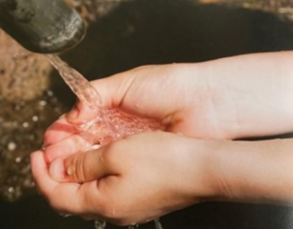
Water is essential to all life on Earth. Global experts warn there could be a 40 percent shortfall in less than 10 years.
Every living thing on Earth needs water to survive. Water sustains natural ecosystems and economic activity. It’s essential for growing food, generating power and extracting critical minerals for technologies like smartphones and electric vehicles.
So, it’s no surprise that our dependency on water makes predicted shortages an urgent concern. The Global Commission on the Economics of Water warns the world could see a 40 percent freshwater shortfall as early as 2030. At the same time, climate change is causing weather shifts and extreme events that put regions at risk of flooding caused by excess water flows.
Text Version
Key terms to know:
Groundwater — Water stored under the surface of the Earth.
Surface water — Water that collects on the surface of the Earth.
Hydrologic system — How water circulates between the Earth and the atmosphere, including evaporation and precipitation. Also called the water cycle.
Watershed — An area of land where precipitation flows into streams, rivers, etc., and then into a common outlet. Also called a drainage basin or catchment.
Weather — Atmospheric conditions at a given place and time, including temperature, humidity, precipitation and more.
Climate — Overall weather conditions typical of a particular region over time.
A first-of-its-kind simulation
Even though Canada has the world’s third-largest store of renewable freshwater, we’re not immune to the effects of changing water supplies: floods, droughts, forest fires, public health threats and more. But up to now there’s been no complete picture of groundwater, surface water and climate interactions across the country.
The three-year Canada1Water project aims to fill in some of those critical blanks by creating a first-of-its-kind simulation of how climate change will affect groundwater and surface water across our country from now to the end of this century. NRCan plays a key role by contributing the largest number of datasets to support model development.
“For almost 25 years, experts have been saying we need an advanced groundwater modelling method that can be applied on a regional scale,” says NRCan project lead, Hazen Russell, a scientist with the Geological Survey of Canada. “The data and technology are finally at a point where we can create one.”
“We’re closing knowledge and data gaps we’ve had for a long time,” says Steve Frey, Russell’s co-lead and director of research at the Ontario-based water science company, Aquanty.
The (literal) big picture
The Canada1Water model combines hydrological, geological and climate data to predict how climate change will affect groundwater and surface water in Canada over the long term. It covers three time periods — 1980 to 2020, 2045 to 2060, and 2085 to the end of the century — across continental Canada, Baffin Island and watersheds we share with the United States.
Three different modelling environments are being integrated to complete the water cycle projections: Aquanty’s HydroGeoSphere platform for groundwater and surface water; the Weather Research and Forecast (WRF) model developed by research agencies in the U.S. for climate; and Community Land Model 5 (CLM5), which is maintained by the U.S. National Centre for Atmospheric Research, for land surface modelling.
“To my knowledge, this is the first comprehensive undertaking of its type not only in Canada but around the world,” says Ed Sudicky, a co-founder of Aquanty. “It has never been done before.”
“The scale of the model, the integration of the datasets, and the fact that users can zoom in on extremely localized areas or zoom out for a big-picture view over time will give researchers a more complete perspective on Canada’s water resources than we’ve ever had before,” says NRCan’s Russell.
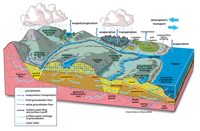
Canada1Water captures the entire hydrological cycle from precipitation and snowmelt to surface water and groundwater interactions.
The scientists developing Canada1Water have also drawn on — and enhanced — many different datasets for climate, land surface, water bodies and drainage, bedrock, surficial geology and soils. Some of which are already being freely shared with the public, and all will be available by the project’s end.
Putting the model to work
Early feedback from users and researchers suggests the Canada1Water model could have nearly unlimited applications.
“Governments at every level, non-governmental organizations, conservation authorities, academic researchers, resource companies, insurance companies, farmers, public safety and defence agencies, Indigenous communities... there is a huge range of users interested in this data because water is such a universal necessity,” Russell says.
A mining company could use Canada1Water to understand water conditions in the area surrounding an open pit mine, adding in more detailed local data to figure out how operations might affect nearby streams and rivers. Cattle ranchers could use the model’s predictions of water availability to manage herd size and help avoid food supply shortages.
“Having a holistic understanding of how water resources change over time and space will support policy development in the agriculture, mining, forestry, environment and public health and safety sectors,” says Agriculture and Agri-Food Canada Research Scientist David Lapen.
Canada1Water also has some unexpected uses. The Cornell Wildlife Health Lab is using the project’s stream dataset to understand the spread of chronic wasting disease, which kills white-tailed deer and other cervid species. The way Canada1Water classifies streams by size using standardized Strahler Stream Order numbers lets the Cornell team and partners at more than 25 U.S. and Canadian wildlife agencies track and model deer movements along stream-related corridors and watering sites throughout North America.
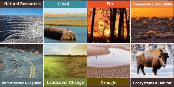
Anticipating the impacts: How will Canada’s groundwater-surface water system respond to climate change? Potential uses of Canada1Water include issues of concern to Canadians from coast to coast to coast.
The time is now
Recognizing the need to act, the Government of Canada has funded the creation of a Canada Water Agency. Consultations on the Agency yielded a set of priorities that Canada1Water is uniquely positioned to support. These priorities include applying “cutting-edge science” to water issues; making data more available; and engaging the public — including Indigenous Peoples — in freshwater management and protection.
“Canada1Water is an excellent demonstration of how leading-edge scientific tools and methodologies in the hands of a collaborative team can help tackle one of the biggest challenges facing Canada over the next century — by identifying impacts and designing mitigation strategies for climate change,” concludes Aquanty’s Frey.
To learn more about Canada1Water, visit the project website at www.canada1water.ca, subscribe to the newsletter and watch Simply Science for morestories in the months ahead.
Canada1Water is a collaboration among Natural Resources Canada (NRCan), Aquanty, Agriculture and Agri-food Canada (AAFC), the University of Toronto and the University of Waterloo. Key NRCan participants are the Geological Survey of Canada (GSC), the Surveyor General Branch, the Canadian Forest Service and the Canadian Centre for Mapping and Earth Observation. The Public Safety and Security Program of Defence Research Development Canada provided the original project funding, with additional contributions from GSC (Groundwater Geoscience and GEM Geo-North programs) and AAFC.