
What, exactly, would happen if an earthquake occurred in your area? A team of experts at Natural Resources Canada have some answers. They’ve crunched the data for a new, online planning tool — RiskProfiler — that provides a risk analysis of the damages, injuries and financial costs that might result from an earthquake. The consequences could be quite staggering.
June 2023
Let’s look at what might happen if a damaging earthquake occurred in Eastern Canada — say, for example, a magnitude 5 earthquake near Montreal, Quebec. The ground could shake from Kitchener, Ontario, to Rimouski, Quebec. Damage would be concentrated in Montreal, where 20 to 30 buildings could collapse. Deaths could number near 100. Total economic losses could reach $11 billion. All this useful information is calculated and summarized by RiskProfiler.
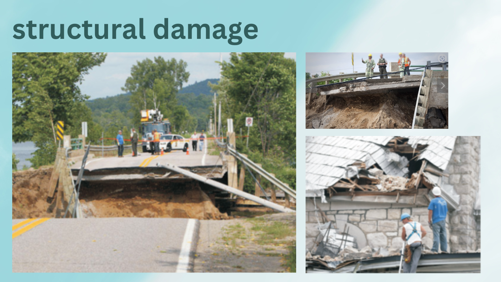
Structural damage following the 2010 magnitude 5 earthquake in Quebec’s Val-des-Bois region, less than 100 kilometres north of Ottawa.
Earthquakes have occurred here before
This scenario is not impossible. In 1732, a damaging earthquake occurred very close to the Island of Montreal. And there have been several major quakes 360 kilometres away, in the Charlevoix seismic zone on the shore of the St. Lawrence River northeast of Quebec City. One earthquake in 1663, with an estimated magnitude of approximately 7.5, was felt over the entire eastern part of North America, triggering vast landslides and practically levelling a waterfall on the St. Maurice River. And the scale of destruction for that region is many times greater today: then, the region was mostly wilderness and sparsely populated, while now the St. Lawrence Valley is teeming with people and developed infrastructure.
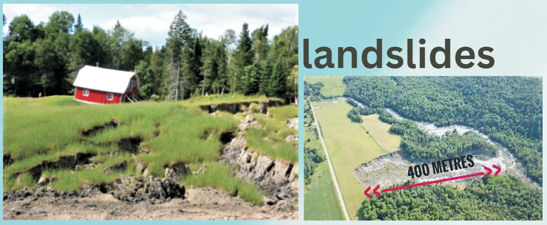
The 2010 magnitude 5 earthquake in the Val-des-Bois region triggered landslides.
RiskProfiler is the first platform of its kind in Canada. It allows people to explore potential risks from earthquakes in incredible detail, all presented in a user-friendly design. It generates estimates that are crucial for communities and governments to plan and prepare for future earthquake events. It also allows users to explore the factors that drive earthquake risk, such as what building types would experience damage, helping decision-makers target risk reduction actions.
Huge consequences
“We’re helping people understand the problem better,” says Philip LeSueur, a geological engineer at NRCan, who studies how earthquakes occur and the risks they pose to society. “Earthquakes have huge consequences — injuries, death, damage, financial costs. If planners and governments know the risks involved, they can make informed decisions on how to manage those risks most effectively. We’re giving them a tool they can use.”
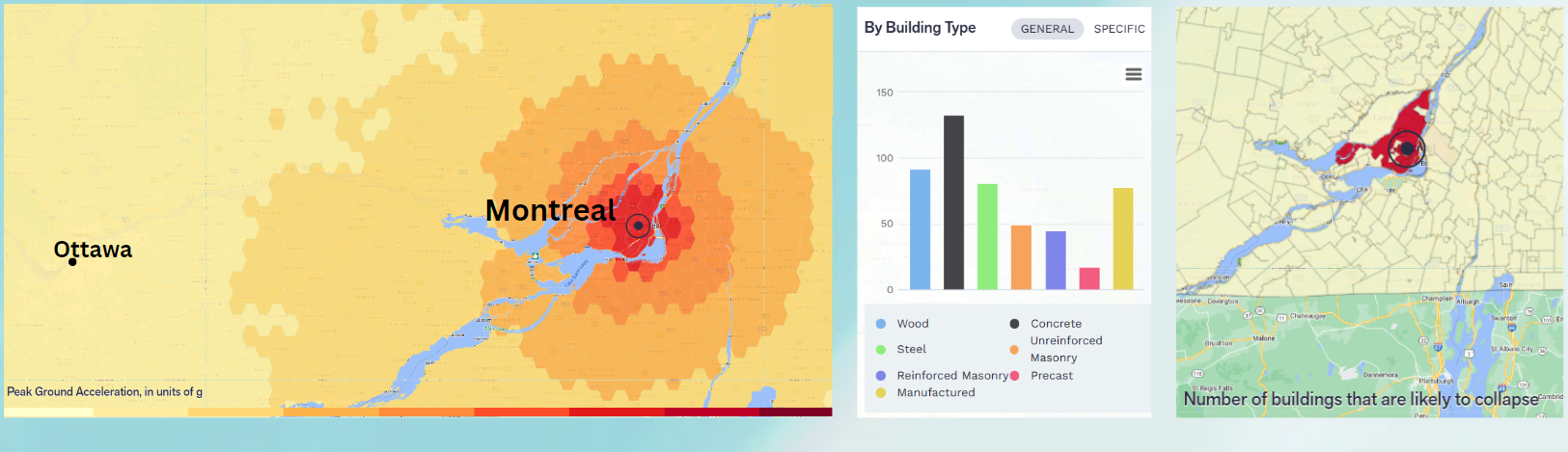
Risk analysis for a magnitude 5 earthquake near Montreal, provided by RiskProfiler.
What are the odds?
There are two different ways of assessing earthquake risk. Most people are familiar with using scenarios to help understand potential impacts of specific events, like the Montreal example above. But NRCan also looks at probabilistic earthquake risk.
“This is a more abstract concept but is just as important because it evaluates the chances of something bad happening,” explains Philip. Probabilistic earthquake risk assessment helps us understand the potential consequences of all earthquakes over time. This data helps researchers and planners understand which communities might bear the largest earthquake impacts. “Put another way, if you’re driving a car and get into a collision, that’s a scenario,” says Philip. “Put another way, if you’re walking your dog in the park and you’re struck by lightning, that’s a scenario,” says Philip. “Yet, if the odds of a person ever being struck by lightening are less than one in a million, that’s the probabilistic risk.”
For risk analysts and community planners, both kinds of information — scenarios and probabilistic risks — are important. The NRCan Earthquake Risk team has spent more than two years building RiskProfiler and over five years assessing earthquake risk in Canada. They use information on past seismic events and credible future earthquakes to project what could happen. They’ve also studied national-scale models of building exposure and structural vulnerability to build their estimates.
Surprising earthquake risks
It may be surprising to learn that NRCan projections show that damages from earthquake risk in Eastern Canada are comparable to those in Western Canada when aging buildings and other structures are taken into consideration. While we often hear about the intimidating fault lines on the West Coast, the risks are similar because earthquake zones in Eastern Canada are found near busy communities. And the buildings and infrastructure there aren’t as resilient to earthquakes, since they tend to be older than buildings in Western Canada, and the materials they’re built from don’t perform as well under earthquake shaking.
Other potential earthquake events identified on RiskProfiler include a magnitude 9.0 Cascadia subduction quake in B.C., a magnitude 5.5 near Ottawa and a magnitude 7.4 event along the Denali Fault in Yukon.
While RiskProfiler was built with the needs of community planners and emergency managers in mind, the platform is available for anyone to use. It therefore represents a real breakthrough, since a publicly available analysis of earthquake risk has only now been achieved on a national scale in Canada, and there are more data and computational tools than ever before.
And this is only the beginning. “We have a goal, as part of this broad global disaster risk reduction plan, to understand the risks of all hazards nationally: floods, wildfires, hurricanes, tornadoes, among others,” says Philip. “RiskProfiler would be a very powerful tool — the framework is now set for an approach to include the risk associated with multiple hazards to align with broader public safety goals.”
RiskProfiler was developed by NRCan’s Geological Survey of Canada in partnership with several organizations: Public Safety Canada, Global Earthquake Model Foundation, NRCan’s Canada Centre for Mapping and Earth Observation, NRCan’s Hazards, Adaptation, and Operations Branch, Insurance Bureau of Canada, Institute for Catastrophic Loss Reduction, Defence Research and Development Canada, Assembly of First Nations, Métis National Council, Canadian Institute of Planners, and Finance Canada.
For more information:
General Earthquake Information (NRCan)