
National Glaciology Project, Glacier Mass Balance (Western Canada)
Glaciers the world over are melting and disappearing. In Western Canada, they’re thinning and retreating at dramatic and ever-increasing rates.
March 2022

National Glaciology Project Monitoring Network, Climate Change Geoscience program, GSC
There’s no question; Canada’s glaciers are changing. That’s why the work of Natural Resources Canada’s Glaciology Project is more urgent than ever. It involves a small team of scientists who track and assess the significant changes now occurring on ice fields and glaciers throughout Canada. This work is important, rewarding and challenging, for several reasons. Maintaining consistent records of glacier ice loss gives climate scientists a clear and up-to-date picture of exactly how glaciers are changing over time. And this information gives decision-makers a valuable tool to identify and plan the most efficient and effective ways we can adapt to a changing climate.
Geological Survey of Canada (GSC) glaciologist Mark Ednie is leading the way. He frequently flies in to some of Western Canada’s most important glaciers in British Columbia, Alberta and the Northwest Territories.
Glaciers are a crucial source of fresh water in Western Canada since they release water into the ecosystem during the dry summer months. But what happens as glaciers retreat and shrink? The reduction of water runoff from melting glaciers will impact water tables, agricultural practices and even the availability of drinking water downstream.

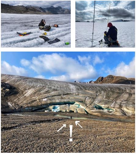
Bologna Glacier, Nahanni National Park and Reserve, NWT. (Photos: Mark Ednie)
Bologna Glacier, Nahanni National Park and Reserve, NWT
Mark and his team travel by helicopter to these remote locations at least twice a year: once in the spring to measure how much snow fell during winter and again in the fall to measure how much ice melted during summer. This data is vital in determining how much the glacier has grown or shrunk that year. Their tasks include servicing weather stations, determining snow depth and density and measuring mass balance stakes, which are metal rods inserted into ice to monitor vertical glacier ice melt. The team drills in the four-metre long stakes by hand or by battery-powered drill, currently there are 16 mass balance stakes spread across the three basins of Bologna Glacier.
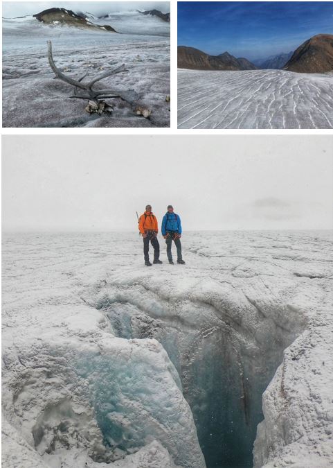
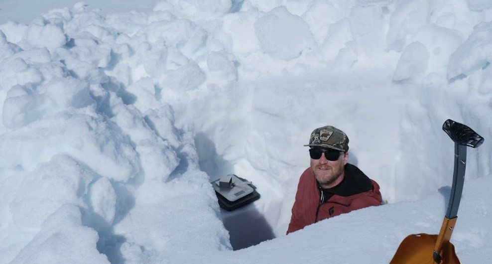
Just four years ago, the person in this image would have been buried under 20 metres of ice. (Photos: Mark Ednie and Laurent Lessard)
On foot or from above, the story is the same
It’s physical work, and it can be very challenging. Here, the team is measuring snow and ice melt in the accumulation zone of Bologna Glacier. This region is the part of the glacier where more snow falls every year than melts, so it’s actually gaining mass. On the other hand, the ablation zone is the part of the glacier that’s losing more ice than it is gaining. As well as challenging, the work requires a high level of expertise in glacier travel and the use of specialized equipment. All field team members are trained in crevasses self-rescue techniques and carry rescue mountaineering equipment such as ropes and harnesses. It’s cold up north, but even with an annual mean air temperature of -6°C, Bologna Glacier is melting and retreating. Just four years ago, the person in this image would have been buried under 20 metres of ice, the equivalent of four storeys. When researchers can’t reach a site in person, they rely on drones to capture high-resolution video and still images to create digital elevation maps to analyze how the glaciers are melting.
An ice-penetrating radar survey indicated that the glacier is about 120 metres thick at the moulin in the picture above. (Photos: Mark Ednie)
The Bologna Glacier is very interesting for several reasons. It is part of the largest ice field in Northwest Territories and provides valuable insight to how glaciers in this region are changing. Meltwater from the glacier flows into the South Nahanni River, which is the centrepiece of Nahanni National Park and Reserve and is an important part of the Dehcho First National traditional territories. The surface of the glacier is continuously changing with new crevasses and drainage features appearing and disappearing on a regular basis. The glacier contains several moulins —circular vertical shafts that drain water from the upper surface of the glacier to the internal drainage systems below. These moulins are of great interest and when new ones appear, researchers note them as potential hazards. The scientists tried to measure the depth of the one here, but it plummeted deeper than their 80-metre measuring tape. An ice-penetrating radar survey indicated that the glacier is about 120 metres thick at the moulin in the picture above.
It’s cold and icy, but the Bologna Glacier isn’t lifeless. Birds nest in rocky outcrops protruding from the ice and caribou, porcupines, wolverines and other wildlife use it as a transportation corridor. Every spring, the team sees multiple caribou tracks, clear evidence of them travelling through to surrounding valleys, which would be difficult, if not impossible, to do if the glacier was not here. Caribou also benefit from the cooler temperatures and the winds flowing down the glacier, which help them escape blackflies and mosquitoes.
Peyto Glacier, Banff National Park, Alberta
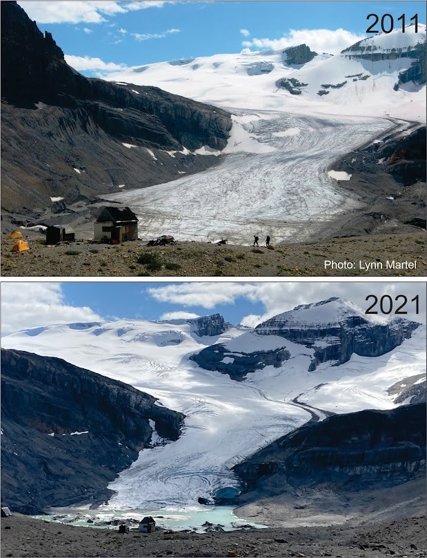
Two photos showing how much the glacier shrunk from 2011 to 2021.
Every year, Mark and a team of researchers spend two to four days on Peyto Glacier, part of the famous Wapta Ice Field in beautiful Banff National Park. After many years of record-warm summer air temperatures, Peyto Glacier is now melting at an alarming rate, as these two images from 2011 and 2021 show. Today, after unprecedented heat domes and wildfires in 2021, Peyto Glacier is almost unrecognizable due to the dramatic retreat of its leading edge, or terminus.
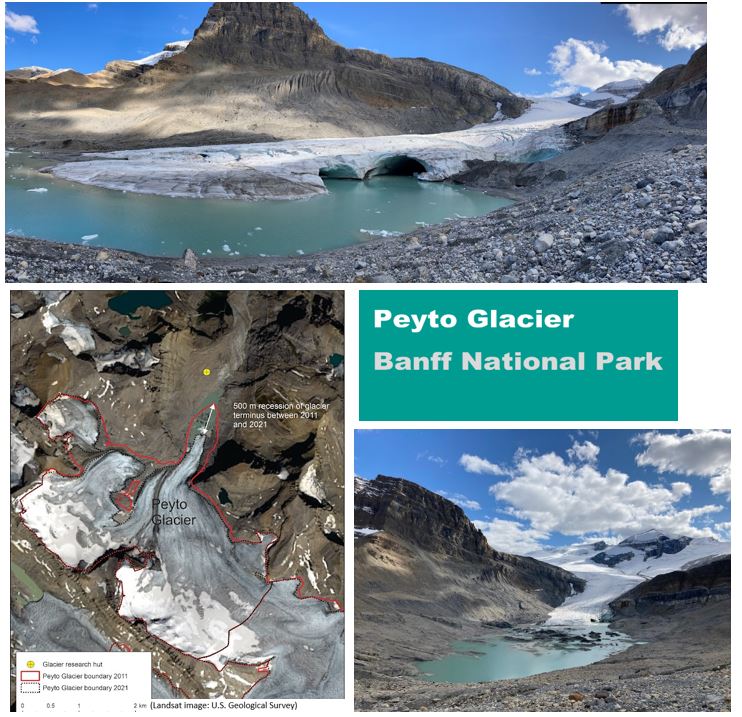
Another source, Landsat optical satellite images from August 2021, shows that the terminus has shrunk dramatically over 10 years — almost 500 metres. Peyto has continued to experience significant melt since then. The proglacial lake has grown dramatically, making it almost impossible to gain access to the glacier on foot in summer.
Every year, Mark measures close to five metres of ice melt at the terminus. This rapid retreat is a real cause for concern since Peyto is one of the major glaciers feeding into the North Saskatchewan River, a major source of water across the Prairie provinces.
Helm Glacier, Garibaldi Provincial Park:
(Photo: Steve Bertollo)
In B.C.’s coastal mountain ranges, the snow pack is typically more than five metres deep, making it difficult to collect snow samples near the ice surface. So Mark digs snow pits about two metres deep and then uses drills to reach deeper samples. Here at Helm Glacier, in Garibaldi Provincial Park near Squamish, B.C., snow samples are weighed to calculate the density of the snow and its overall water content.
After a busy period of travel in the spring and fall, Mark returns to his research. He analyzes the data, shares his findings, drafts papers and organizes his photos and videos. While this research doesn’t always result in good news, it’s vital. Keeping pace with our most important glaciers is one of the very few ways we have to demonstrate the dramatic changes to some of our iconic geological features and to give decision-makers the information they need to plan ahead.
This expedition was made possible through NRCan’s Polar Continental Shelf Program (PCSP). This long-standing centre of excellence has a well-developed logistics network that includes everything — from base camp gear, chartered aircraft, and snowmobiles to a year-round hub in Resolute, Nunavut — that helps scientists focus on their important studies. In pre-pandemic times, the PCSP supported more than 1,000 expeditions to Canada’s North every year.
For more information:
Glaciers in Canada, Natural Resources Canada
Glaciers in Canada | The Canadian Encyclopedia