
In the race to adapt to climate change, being able to anticipate future trends is critical. This requires good models built on reliable data. After three years of intense research and development, the first full-scale simulation of how climate change could impact groundwater and surface water resources in Canada is now available. This new model — called Canada1Water (C1W) — provides a science-based view to the end of the century.
May 2024
“You need big-picture data to make big-picture decisions,” says Hazen Russell, a Canada1Water (C1W) co-lead and a scientist with the Geological Survey of Canada’s Groundwater Geoscience Program. “Canada1Water provides that by stitching thousands of datapoints into an integrated model that shows how groundwater and surface water levels could change all across the country over the next 75 years.”
The model and other related resources are available through a free, easy-to-use web portal. Users can download finalized datasets and simulations dating back to 1981 and looking ahead to the end of this century.

People can access C1W online to work with the simulation results. Here are just a few of the datasets available: water depth to bedrock, surficial geology and landcover type.
Completing the model in just three years was a heavy lift. It demanded the ‘all-hands’ effort of a diverse team of scientists with expertise in various fields.
The project is also a timely one, given the growing global concerns about freshwater availability. Some researchers warn of a global groundwater crisis and stories about groundwater depletion continue to make headlines.
High stakes, big challenges
Water is crucial for life on Earth. It’s no exaggeration to say water is the most important resource on the planet. When our water supplies decline, it impacts everything from our health and food security to our economy and geopolitical stability. Groundwater is especially important since at least half of all surface water — including streams, rivers, lakes and creeks, and even oceans — comes from groundwater sources.

Much of the water found on the planet’s surface comes from groundwater resources. Groundwater itself is found below the surface.
A big challenge
Getting an accurate assessment of groundwater supplies is difficult because it collects underground where it’s hard to see and measure. And while the Canadian government and industries monitor water resources in Canada, their efforts don’t provide a cohesive picture of the country as a whole.
As a result, a huge part of the job for the C1W team was to bridge these and many other information gaps. The work demanded a broad range of skills, including hydrology, geology, sedimentology, geophysics, climatology and forestry as well as fluid dynamics, data science, software development and more.
“When you look at the range of skillsets and knowledge we have on this project — with people from government, the private sector and academia — you see how complex hydrology really is,” says Steven Frey, Hazen’s co-lead and director of research at the private water science company, Aquanty.
Cracking the code
Creating the Canada1Water simulation was no easy task. The team had to combine three different models just to build the foundation: one for climate, one for land surface processes, and one for how groundwater and surface water flows. To make sure each one was complete and accurate for Canada, the team added dozens of data sets with extra detail.
“One of the things we ran into right away,” says Aquanty hydrogeologist Eric Kessel, “was that the datasets were either incomplete, didn’t match the scale of the other ones we were using, or didn’t match real-world observations. We had to fix all of that, bit by bit, to have everything work together.”
In some cases, existing maps didn’t show key elements such as bedrock outcrops, those places where subsurface rock breaks through above ground or peatland. Peatlands are a distinctive feature of many parts of the Canadian landscape and have specific effects on water flow.
“Bedrock outcrops and peatland make up nearly 25 percent of the total area of the country,” says Eric, “so we had to add those into the soil maps we were using.”
Another issue the team had to face was the very Canadian phenomenon of snow, which has unique characteristics and isn’t measured in all places. They gathered whatever observational data they could and then augmented that by developing an innovative machine learning technique that could correct snowmelt models accurately.
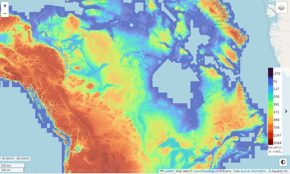
Decision-makers, researchers and the public can access C1W for free online to work with the simulation results, zooming in on specific regions or zooming out for a complete nationwide view from coast to coast to coast.
Pre-launch results show changes ahead
The team ran early versions of the simulation in specific parts of the country to fine-tune the model. The first of those focused on the Mackenzie River Basin and predicted some definite patterns in Canada’s northwest: wetter winters, drier summers and lower levels of stored groundwater by the end of the century.
Understanding these future trends could be invaluable for community development, infrastructure planning, wildfire management, food production, and more.
“Being able to explore the hydrological cycle interactively from the local level up to continental scale will reveal hydro-climate interdependencies like never before,” says David Lapen, research scientist and C1W project lead at Agriculture and Agri-Food Canada. “It will also point to controls we can use to cope with water-related stresses in the future, which are especially of interest to agriculture.”
Hazen adds that he hopes the launch of C1W is just the beginning of something much longer-term. He points to similar projects in other countries like United States, Britain and Denmark, where national water models are being developed with long range support. The C1W project has received an additional five years of funding from the Geological Survey of Canada and will continue to seek partners for collaboration.
“With all the work that’s gone into the model, we can’t wait for people to use it,” says Hazen. “We want to dig deeper into the analysis and keep filling gaps in the simulation to help society adapt to changing water resources over the coming decades.”