
The first week of May is Emergency Preparedness Week in Canada. Led by Public Safety Canada, it’s an opportunity for you to take action to ensure you’re prepared to protect yourself, your family and your community for a range of emergencies.
May 2021
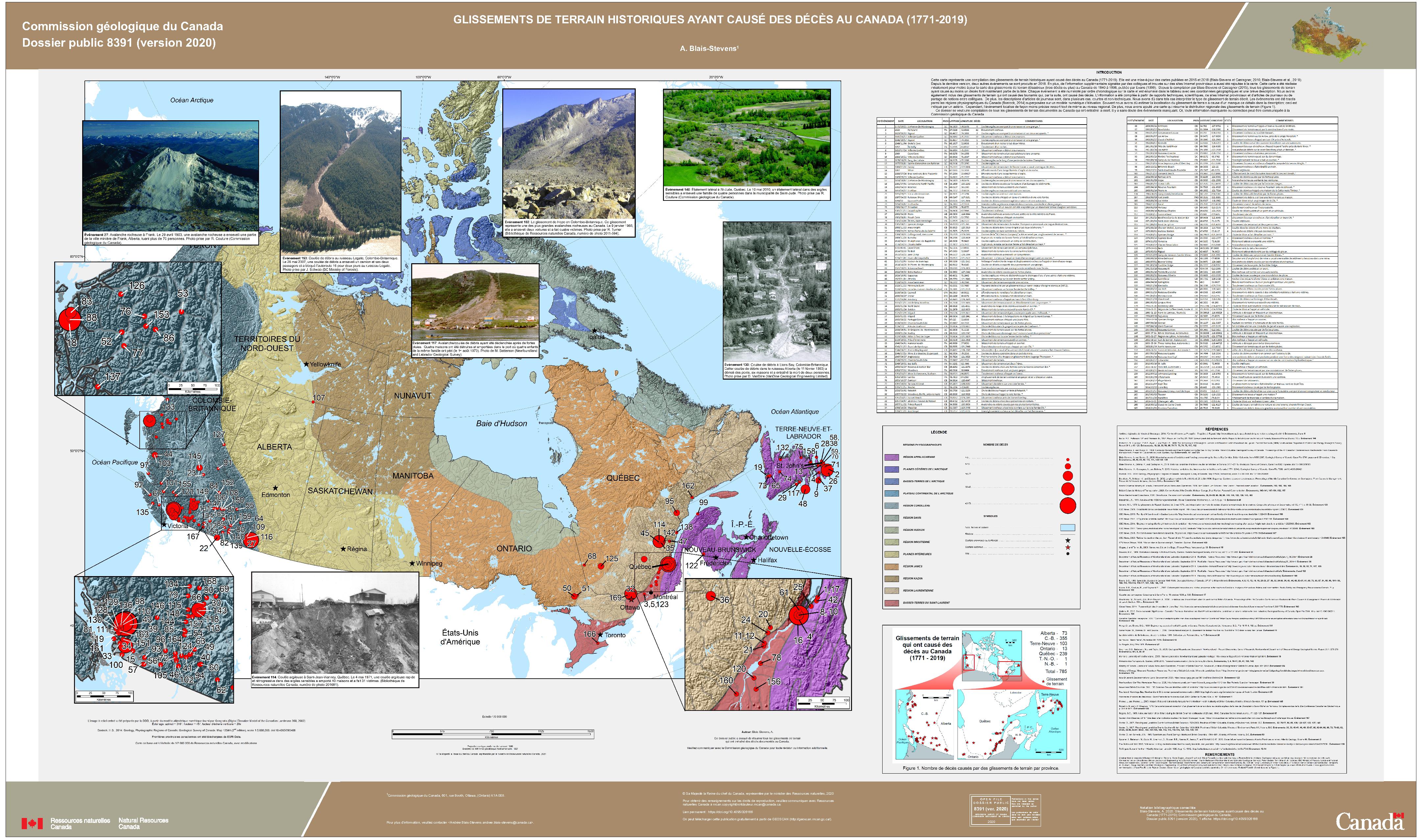
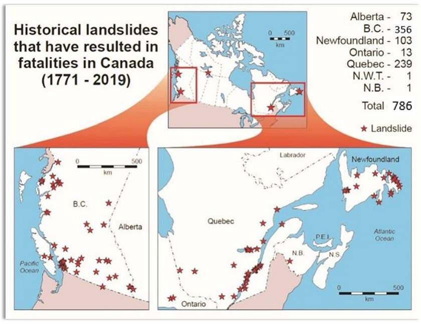
If you live in a high-risk area in the Canadian Rockies or along a vulnerable waterway, you may already be prepared for a landslide. Not only is it good practice, but it could save lives. Landslides are common in Canada — thousands occur across the country every year. Most of them aren’t fatal, but at least 786 Canadians have perished in landslides in Canada since 1771.
It’s all documented on a recently published map entitled Historical Landslides That Have Resulted in Fatalities in Canada.
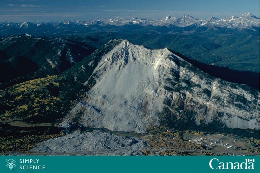
The Frank Slide buried part of the mining town of Frank, Alberta, on April 29, 1903. Over 82 million tonnes of limestone rock slid down Turtle Mountain. The landslide is Canada's deadliest in history, killing 73 people. Source: R. Couture, Geological Survey of Canada
Natural Resources Canada research scientist Andrée Blais-Stevens has combed through vast amounts of data and historical records to identify the type and location of fatal landslides from 1771 to 2019 across Canada.
Common causes
“Landslides most often happen in rocky, mountainous areas, but invisible underlying geologic conditions such as sensitive clay can collapse, causing landslides,” says Blais-Stevens. “This unstable soil is the most common cause of landslides in the St. Lawrence Valley, Ottawa to Quebec City, and as far as the Saguenay region.”
British Columbia fatalities due to landslides total 356, followed by Quebec at 239. Newfoundland is third at 103 fatalities. May 4, 2021, was the 50th anniversary of a fatal landslide in Saint-Jean-Vianney, where 31 people were killed.
The Challenge
Climate events like heavy rainfall can trigger landslides, creating public safety risks where roads, pipelines or railways are built on or near soft soil or steep slopes. In wetland areas, freeze/thaw cycles can cause significant structural damage to pipelines over time. Debris flows — swiftly moving masses of mud, sand, soil, rock, water and air pulled forcefully down slopes by gravity — are also dangerous. Weak mountain bedrock can fail, leading to rock slides or rockfalls.
NRCan research scientist Andrée Blais-Stevens has combed through vast amounts of data and historical records to identify the type and location of fatal landslides from 1771 to 2019 across Canada.
Text version
| Historical landslides that have resulted in fatalities in Canada (1771 – 2019) |
|
|---|---|
| Alberta | 73 |
| B.C. | 356 |
| Newfoundland | 103 |
| Ontario | 13 |
| Quebec | 239 |
| N.W.T. | 1 |
| N.B. | 1 |
| Total | 786 |
Engineers can use this historical landslide map and database to conduct risk analysis when constructing homes or other types of infrastructure, such as roads or bridges, to help ensure they’re not built at the sites of historic landslides. Decade by decade, there are far fewer fatalities. “By highlighting areas that are more prone to landslides, I hope our research will help decision-makers and stakeholders decide how to mitigate against hazards when they’re choosing where to build roads, pipelines or railways,” says Blais-Stevens.
For more information:
Read:
More about Andrée Blais-Stevens’ work on ResearchGate
Explore:
Link to map “Historical Landslides That Have Resulted in Fatalities in Canada” (48mb file):