
Canadian Forest Fire Danger Rating System
The Canadian Forest Fire Danger Rating System (CFFDRS) uses a system of scientific models to assess wildland fire danger and estimate fire behaviour. It is the principal source of fire information for all wildland fire management agencies in Canada. It is also the most widely applied wildland fire danger rating system in the world.
Fire danger is an assessment of fixed and variable factors of the fire environment that determine:
- the ease of ignition
- rate of spread
- difficulty of control
- fire impact
Fire danger rating is a process that systematically evaluates and integrates factors influencing fire danger. It is represented by fire danger indexes.
Wildland fire managers use outputs from the CFFDRS to determine the level of preparedness needed to:
- minimize impacts
- isolate days with high fire activity potential
Between May to September, hundreds of wildland fires may burn simultaneously. Not every fire needs to be extinguished as many burn themselves out or are put out by wet weather. Not every fire can be extinguished because of limited resources, fire intensity or inaccessible location.
Wildland fire managers assess which fires threaten human safety, property, environmental or cultural assets, and which fires can be monitored without suppression actions. The CFFDRS helps wildland fire managers determine what wildland firefighting resources are needed and where. Decisions are made based on information from the CFFDRS, expert knowledge and observations of the fire environment.
Structure of the CFFDRS
The CFFDRS is a series of linked sub-systems. Together, these systems predict the potential fire danger within a forest.
Inputs include:
- topography
- fuels
- weather
- Canada’s Fire Weather Index (FWI) System, which uses daily weather conditions to estimate potential fire danger across a large landscape. The FWI System tracks how wet or dry dead fuels are day-to-day and calculates indexes of fire spread rate, fuel consumption and fire intensity.
- Canada’s Fire Behaviour Prediction (FBP) System , which provides quantitative estimates of:
- the rate of spread
- fuel consumption
- fire intensity based on local site conditions (topography), fuels and inputs from the FWI System
The FBP System helps wildland fire managers assess:
- how fast a fire could spread in a particular forest type
- how much fuel might be consumed
- fire type (surface or crown fire)
- the Accessory Fuel Moisture (AFM) System
- regionally developed Fire Occurrence Prediction (FOP) Systems for lightning- and human-caused fires
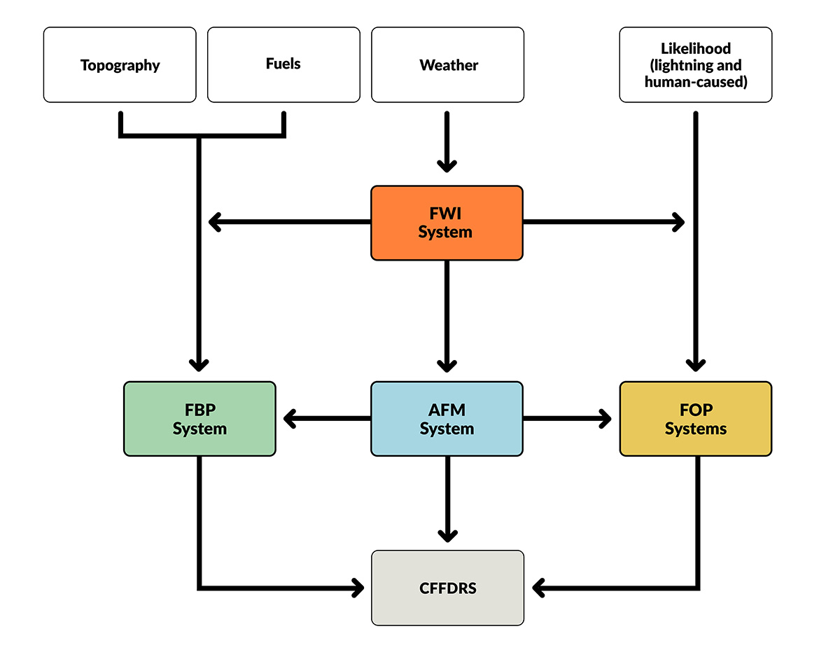
Text version
Flow chart showing the sub-systems of the Canadian Forest Fire Rating Danger System (CFFDRS). Inputs include:
- topography
- fuels
- weather
- likelihood (lightning- and human-caused)
Linked sub-systems are the:
- Fire Weather Information (FWI) System
- Fire Behaviour Prediction (FBP) System
- Accessory Fuel Moisture (AFM) System
- regional Fire Occurrence Prediction (FOP) Systems
International uptake of the CFFDRS
Canada is recognized as a global leader in wildland fire science and wildland fire management.
The CFFDRS has been fully implemented in parts of the United States and New Zealand. Components of the system have been adapted in countries including Spain, Portugal, Sweden, Switzerland, Costa Rica, Argentina, Fiji, Indonesia and Malaysia.
The CFFDRS is popular because it:
- is relatively simple to use
- can be adapted to a variety of environments
- includes many interpretation aids, posters, reference tables, electronic data-processing and display systems) that support a variety of situations
The future of the CFFDRS
The decision-making environment for wildland fire managers has changed considerably over the past few decades. One key concern is the expansion of the wildland-urban interface, leading to more communities and resources being at risk. Advances in remote sensing, greater use of information technology and the increasing rapidity of communication have put more detailed and more up-to-date information in the hands of wildland fire managers.
The Canadian government started researching forest fire danger rating in 1925. Since then, five different fire danger rating systems have been developed. Each subsequent iteration was refined on previous systems, field experiments and practical analysis.
The CFFDRS continues to evolve. Ongoing research, operational experience, technological advancements and expanding data are being incorporated as wildland fire management challenges change.
- cffdrs: an R package for the Canadian Forest Fire Danger Rating System (2017)
- Interpreting and using outputs from the Canadian Forest Fire Danger Rating System in research applications (2009)
- Weather Guide for the Canadian Forest Fire Danger Rating System (2008)
- Science, technology, and human factors in fire danger rating: the Canadian experience (2006)
- The Canadian Forest Fire Danger Rating System: an overview (1989)
Page details
- Date modified: