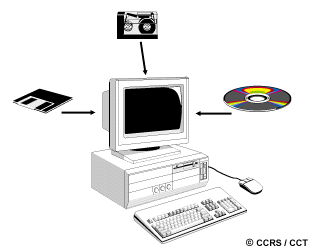
In today's world of advanced technology where most remote sensing data are recorded in digital format, virtually all image interpretation and analysis involves some element of digital processing. Digital image processing may involve numerous procedures including formatting and correcting of the data, digital enhancement to facilitate better visual interpretation, or even automated classification of targets and features entirely by computer. In order to process remote sensing imagery digitally, the data must be recorded and available in a digital form suitable for storage on a computer tape or disk. Obviously, the other requirement for digital image processing is a computer system, sometimes referred to as an image analysis system, with the appropriate hardware and software to process the data. Several commercially available software systems have been developed specifically for remote sensing image processing and analysis.
For discussion purposes, most of the common image processing functions available in image analysis systems can be categorized into the following four categories:
- Preprocessing
- Image Enhancement
- Image Transformation
- Image Classification and Analysis
Preprocessing functions involve those operations that are normally required prior to the main data analysis and extraction of information, and are generally grouped as radiometric or geometric corrections. Radiometric corrections include correcting the data for sensor irregularities and unwanted sensor or atmospheric noise, and converting the data so they accurately represent the reflected or emitted radiation measured by the sensor. Geometric corrections include correcting for geometric distortions due to sensor-Earth geometry variations, and conversion of the data to real world coordinates (e.g. latitude and longitude) on the Earth's surface.
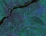

The objective of the second group of image processing functions grouped under the term of image enhancement, is solely to improve the appearance of the imagery to assist in visual interpretation and analysis. Examples of enhancement functions include contrast stretching to increase the tonal distinction between various features in a scene, and spatial filtering to enhance (or suppress) specific spatial patterns in an image.
Image transformations are operations similar in concept to those for image enhancement. However, unlike image enhancement operations which are normally applied only to a single channel of data at a time, image transformations usually involve combined processing of data from multiple spectral bands. Arithmetic operations (i.e. subtraction, addition, multiplication, division) are performed to combine and transform the original bands into "new" images which better display or highlight certain features in the scene. We will look at some of these operations including various methods of spectral or band ratioing, and a procedure called principal components analysis which is used to more efficiently represent the information in multichannel imagery.
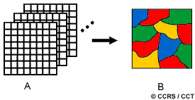
Image classification and analysis operations are used to digitally identify and classify pixels in the data. Classification is usually performed on multi-channel data sets (A) and this process assigns each pixel in an image to a particular class or theme (B) based on statistical characteristics of the pixel brightness values. There are a variety of approaches taken to perform digital classification. We will briefly describe the two generic approaches which are used most often, namely supervised and unsupervised classification.
In the following sections we will describe each of these four categories of digital image processing functions in more detail.
Did you know?
"...our standard operating procedure is..."
... the remote sensing industry and those associated with it have attempted to standardize the way digital remote sensing data are formatted in order to make the exchange of data easier and to standardize the way data can be read into different image analysis systems. The Committee on Earth Observing Satellites (CEOS) have specified this format which is widely used around the world for recording and exchanging data.
Whiz quiz

One 8-bit pixel takes up one single byte of computer disk space. One kilobyte (Kb) is 1024 bytes. One megabyte (Mb) is 1024 kilobytes. How many megabytes of computer disk space would be required to store an 8-bit Landsat Thematic Mapper (TM) image (7 bands), which is 6000 pixels by 6000 lines in dimension?
The answer is ...
Whiz quiz - answer

If we have seven bands of TM data, each 6000 pixels by 6000 lines, and each pixel takes up one byte of disk space, we have:
7 x 6000 x 6000 = 252,000,000 bytes of data
To convert this to kilobytes we need to divide by 1024, and to convert that answer to megabytes we need to divide by 1024 again!
252,000,000 (1024 x 1024) = 240.33 megabytes
So, we would need over 240 megabytes of disk space just to hold one full TM image, let alone analyze the imagery and create any new image variations! Needless to say, it takes a lot of storage space and powerful computers to analyze the data from today's remote sensing systems.