Background
As the Earth's population increases and national economies continue to move away from agriculture based systems, cities will grow and spread. The urban sprawl often infringes upon viable agricultural or productive forest land, neither of which can resist or deflect the overwhelming momentum of urbanization. City growth is an indicator of industrialization (development) and generally has a negative impact on the environmental health of a region.
The change in land use from rural to urban is monitored to estimate populations, predict and plan direction of urban sprawl for developers, and monitor adjacent environmentally sensitive areas or hazards. Temporary refugee settlements and tent cities can be monitored and population amounts and densities estimated.
Analyzing agricultural vs. urban land use is important for ensuring that development does not encroach on valuable agricultural land, and to likewise ensure that agriculture is occurring on the most appropriate land and will not degrade due to improper adjacent development or infrastructure.
Why remote sensing?
With multi-temporal analyses, remote sensing gives a unique perspective of how cities evolve. The key element for mapping rural to urban landuse change is the ability to discriminate between rural uses (farming, pasture forests) and urban use (residential, commercial, recreational). Remote sensing methods can be employed to classify types of land use in a practical, economical and repetitive fashion, over large areas.
Data requirements
Requirements for rural / urban change detection and mapping applications are 1) high resolution to obtain detailed information, and 2) multispectral optical data to make fine distinction among various land use classes.
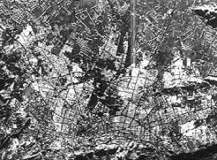
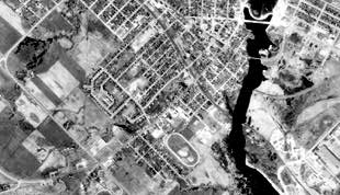
Sensors operating in the visible and infrared portion of the spectrum are the most useful data sources for land use analysis. While many urban features can be detected on radar and other imagery (usually because of high reflectivity), VIR data at high resolution permits fine distinction among more subtle land cover/use classes. This would permit a confident identification of the urban fringe and the transition to rural land usage. Optical imagery acquired during winter months is also useful for roughly delineating urban areas vs. non-urban. Cities appear in dramatic contrast to smooth textured snow covered fields.

Radar sensors also have some use for all urban/rural delineation applications, due to the ability of the imaging geometry to enhance anthropogenic features, such as buildings, in the manner of corner reflectors. The optimum geometric arrangement between the sensor and urban area is an orientation of linear features parallel to the sensor movement, perpendicular to the incoming incident EM energy.
Generally, this type of application does not require a high turnaround rate, or a frequent acquisition schedule.
Canada vs. International

Throughout the world, requirements for rural/urban delineation will differ according to the prevalent atmospheric conditions. Areas with frequently cloudy skies may require the penetrating ability of radar, while areas with clear conditions can use airphoto, optical satellite or radar data. While the land use practices for both rural and urban areas will be significantly different in various parts of the world, the requirement for remote sensing techniques to be applied (other than the cloud-cover issue) will be primarily the need for fine spatial detail.
Case study (example)
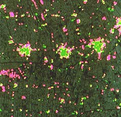
 This image of land cover change provides multitemporal information in the form of urban growth mapping. The colours represent urban land cover for two different years. The green delineates those areas of urban cover in 1973, and the pink, urban areas for 1985. This image dramatically shows the change in expansion of existing urban areas, and the clearing of new land for settlements over a 12 year period. This type of information would be used for upgrading government services, planning for increased transportation routes, etc.