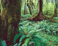
 Forests are a valuable resource providing food, shelter, wildlife habitat, fuel, and daily supplies such as medicinal ingredients and paper. Forests play an important role in balancing the Earth's CO2 supply and exchange, acting as a key link between the atmosphere, geosphere, and hydrosphere. Tropical rainforests, in particular, house an immense diversity of species, more capable of adapting to, and therefore surviving, changing environmental conditions than monoculture forests. This diversity also provides habitat for numerous animal species and is an important source of medicinal ingredients. The main issues concerning forest management are depletion due to natural causes (fires and infestations) or human activity (clear-cutting, burning, land conversion), and monitoring of health and growth for effective commercial exploitation and conservation.
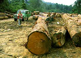 Humans generally consider the products of forests useful, rather than the forests themselves, and so extracting wood is a wide-spread and historical practice, virtually global in scale. Depletion of forest resources has long term effects on climate, soil conservation, biodiversity, and hydrological regimes, and thus is a vital concern of environmental monitoring activities. Commercial forestry is an important industry throughout the world. Forests are cropped and re-harvested, and the new areas continually sought for providing a new source of lumber. With increasing pressure to conserve native and virgin forest areas, and unsustainable forestry practices limiting the remaining areas of potential cutting, the companies involved in extracting wood supplies need to be more efficient, economical, and aware of sustainable forestry practices. Ensuring that there is a healthy regeneration of trees where forests are extracted will ensure a future for the commercial forestry firms, as well as adequate wood supplies to meet the demands of a growing population.
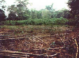 Non-commercial sources of forest depletion include removal for agriculture (pasture and crops), urban development, droughts, desert encroachment, loss of ground water, insect damage, fire and other natural phenomena (disease, typhoons). In some areas of the world, particularly in the tropics, (rain) forests, are covering what might be considered the most valuable commodity - viable agricultural land. Forests are burned or clear-cut to facilitate access to, and use of, the land. This practice often occurs when the perceived need for long term sustainability is overwhelmed by short-term sustenance goals. Not only are the depletion of species-rich forests a problem, affecting the local and regional hydrological regime, the smoke caused by the burning trees pollutes the atmosphere, adding more CO2, and furthering the greenhouse effect.
Of course, monitoring the health of forests is crucial for sustainability and conservation issues. Depletion of key species such as mangrove in environmentally sensitive coastline areas, removal of key support or shade trees from a potential crop tree, or disappearance of a large biota acting as a CO2 reservoir all affect humans and society in a negative way, and more effort is being made to monitor and enforce regulations and plans to protect these areas.
International and domestic forestry applications where remote sensing can be utilized include sustainable development, biodiversity, land title and tenure (cadastre), monitoring deforestation, reforestation monitoring and managing, commercial logging operations, shoreline and watershed protection, biophysical monitoring (wildlife habitat assessment), and other environmental concerns.
General forest cover information is valuable to developing countries with limited previous knowledge of their forestry resources. General cover type mapping, shoreline and watershed mapping and monitoring for protection, monitoring of cutting practices and regeneration, and forest fire/burn mapping are global needs which are currently being addressed by Canadian and foreign agencies and companies employing remote sensing technology as part of their information solutions in foreign markets.
Forestry applications of remote sensing include the following:
- 1) reconnaissance mapping:
- Objectives to be met by national forest/environment agencies include forest cover updating, depletion monitoring, and measuring biophysical properties of forest stands.
- forest cover type discrimination
- agroforestry mapping
- 2) Commercial forestry:
- Of importance to commercial forestry companies and to resource management agencies are inventory and mapping applications: collecting harvest information, updating of inventory information for timber supply, broad forest type, vegetation density, and biomass measurements.
- clear cut mapping / regeneration assessment
- burn delineation
- infrastructure mapping / operations support
- forest inventory
- biomass estimation
- species inventory
- 3) Environmental monitoring
- Conservation authorities are concerned with monitoring the quantity, health, and diversity of the Earth's forests.
- deforestation (rainforest, mangrove colonies)
- species inventory
- watershed protection (riparian strips)
- coastal protection (mangrove forests)
- forest health and vigour
Canadian requirements for forestry application information differ considerably from international needs, due in part to contrasts in tree size, species diversity (monoculture vs. species rich forest), and agroforestry practices. The level of accuracy and resolution of data required to address respective forestry issues differs accordingly. Canadian agencies have extensive a priori knowledge of their forestry resources and present inventory and mapping needs are often capably addressed by available data sources.
For Canadian applications requirements, high accuracy (for accurate information content), multispectral information, fine resolution, and data continuity are the most important. There are requirements for large volumes of data, and reliable observations for seasonal coverage. There is a need to balance spatial resolution with the required accuracy and costs of the data. Resolution capabilities of 10 m to 30 m are deemed adequate for forest cover mapping, identifying and monitoring clearcuts, burn and fire mapping, collecting forest harvest information, and identifying general forest damage. Spatial coverage of 100 - 10000 km2 is appropriate for district to provincial scale forest cover and clear cut mapping, whereas 1-100 km2 coverage is the most appropriate for site specific vegetation density and volume studies.
Tropical forest managers will be most concerned with having a reliable data source, capable of imaging during critical time periods, and therefore unhindered by atmospheric conditions.
Did you know?
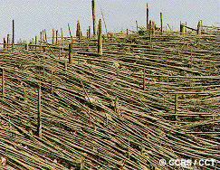
Natural disasters can also wipe out huge areas of forest. Burns can destroy several thousand of hectares, landslides can displace trees down a slope, and excessive flooding can damage trees. Volcanoes however, have the greatest potential for destroying forests in the shortest amount of time. In 1980, Mt. St. Helens in northwestern United States violently erupted. The volcanic blast, reaching 320 km/hour, levelled over 600km2 of forest.
Whiz quiz
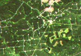
Why are lines being cut out of this forested area in northern Alberta?
The answer is ...
Whiz quiz - answer

In northern Alberta, forests are being cut for pulp and paper mills, but they are also being cut for another reason. Exploration and infrastructure for gas wells requires that forests be cut for seismic lines, pipeline routing, access to sites, and pumping stations.