
Understanding fire behaviour is critical for managing wildland fires. It is about how:
- fuels ignite
- flames develop
- fire spreads and is extinguished
Factors such as fuel, weather and topography control:
- flame characteristics
- rate of fire spread
- direction of spread
- intensity of a wildland fire
Canadian researchers conduct experimental fires and study wildland fires under various conditions. Over decades, a system of scientific models to predict fire spread, intensity and growth across Canadian landscapes have been developed. These tools are invaluable for preparing for and responding to wildland fire.
Ignition, growth and extinguishment
After a wildland fire ignites, a front develops where flaming combustion occurs. Flame height indicates fire intensity – the amount of heat released, which is highest at the head and decreases along a fire’s flanks and back. Fire intensity usually increases during the day as temperatures rise and humidity drops and decreases at night as these conditions reverse.
Fire is self-sufficient as long as:
- oxygen is available
- dry fuel is available
- enough energy is produced to reach its combustion temperature
Removing any one element puts out a fire.
Smouldering combustion occurs behind the flame front and can last minutes, hours or days.
Wildland firefighters suppress fire spread by:
- applying water, retardants or dirt to:
- cut off oxygen
- extinguish flames
- cool fuels below their combustion temperature
- clearing fuels
- creating firebreaks using:
- hand tools
- heavy equipment
- backburns
Uncontrolled wildland fires can burn for days to months until fuel is gone or precipitation (rain or snow) raises fuel moisture.
Smoke and firebrands
Incomplete flaming and smouldering combustion produce smoke that contains:
- fine particulates
- carbon dioxide
- carbon monoxide
- water
- many other organic compounds
Smoke from low-intensity fires typically impacts local air quality. Smoke from large fires can travel hundreds to thousands of kilometres, affecting distant regions.
Intense fires create buoyant smoke plumes that rise tens to thousands of metres, carrying firebrands—partially burned materials capable of igniting new fires. Firebrands are a primary means of fire spread and the leading cause of structural ignitions by wildland fires.
Powerful updrafts from extreme wildland fires can create unpredictable atmospheric conditions, generating their own weather. Extreme fires can form pyro-cumulonimbus (pyro-Cb) clouds—thunderstorm-like clouds towering 10 to 15 kilometres that often produce dry lightning.
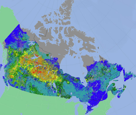
“Made in Canada” fire behaviour
Fire behaviour varies across Canada because of:
- diverse fuels (grasslands, shrublands, boreal and temperate forests, peatlands)
- weather (wind, air temperature, precipitation, relative humidity)
- topography (slope angle and/or direction, elevation)
According to the Fire Weather Index (FWI), fire spread and intensity increase with hot, dry, windy weather, peaking during the day and dropping overnight.
Grass, shrubs or logging slash
Surface fires spread rapidly through organic vegetation. Spread rates can reach up to 12 km/h. Flame heights can exceed 10 metres in extreme conditions.
Forests
Fires often start in organic surface material such as needle and leaf litter. Spread rates are typically less than 0.3 km/h. Moderate flame heights and intensity are managed with firefighting resources.
- Deciduous forests: Surface fires occur in spring after snowmelt. Fires spread more slowly after green-up and rarely support crown fires.
- Coniferous forests: Intense surface fires can ignite tree canopy. Spread rates for crown fire are up to 6 km/h, with flames several times tree height. Crown fires have extreme intensities and are often uncontrollable.
Peat and humus
Smouldering ground fires burn slowly in deep organic layers and can be difficult to extinguish. During drought, fires can smoulder underground through winter and reemerge in spring.
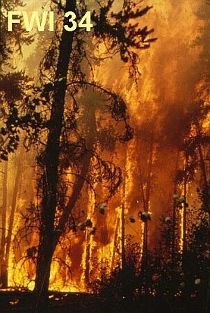
Examples of fire behaviour in jack pine
During the 1974 fire season, the Alberta Forest Service, the Canadian Forest Service and three other federal agencies completed a short-term program of experimental fires in the jack pine forests of northeastern Alberta. The results of the study confirmed the strong relationship that exists between the various aspects of fire behaviour and the components of Canada’s Fire Weather Index System.
Examples of fire behaviour in an upland jack pine (Pinus banksiana Lamb.) stand in order of increasing FWI levels.
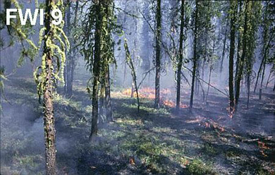
FWI 9: Creeping surface fire
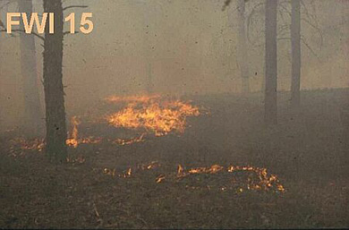
FWI 15: Low vigor surface fire
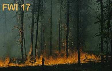
FWI 17: Moderately vigorous surface fire
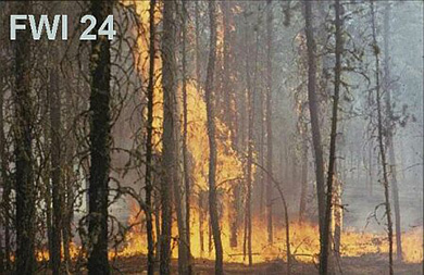
FWI 24: Very intense surface fire
- Drought triggers and sustains overnight fires in North America (2024)
- Fuel types misrepresent forest structure and composition in interior British Columbia: a way forward (2024)
- Broadleaf-tree phenology and springtime wildfire occurrence in boreal Canada (2023)
- Fire behaviour in jack pine stands as related to the Canadian Forest Fire Weather Index System (Poster) (1988)
- Development and Structure of the Canadian Forest Fire Weather Index System (1987)
- Fire behaviour in upland jack pine: the Darwin Lake Project (1977)