
The sensor on board a satellite records an image - What happens next?
- How does that image get from the satellite to the Earth?
- What happens to that image in transit?
- How do we get a usable copy of that image?
Follow the process step-by-step as we illustrate how a satellite image travels from space to become a usable product on the ground.
Table of Contents
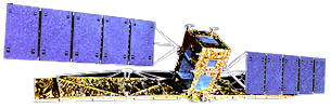
Remote Sensing Satellites
Constellation of Satellites

The Earth is being imaged each day by a "constellation" of remote sensing satellites. Built and launched by a variety of international agencies these satellites have their own special systems of imaging sensors which make use of the visible, infrared, microwave and other parts of the electromagnetic spectrum.
Orbits
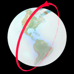
Remote sensing (or Earth Observation) satellites are usually in a "near-polar" orbit, missing the Earth's poles by several degrees. The convention is that those orbit segments which proceed north-to-south are termed "descending", while those proceeding south-to-north are termed "ascending".
Passive and Active Sensors
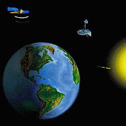
If a sensor is designed to record radiation from the sun, as reflected by the Earth, then such a "passive" sensor can only record images while observing the sun-lit side of the Earth. Other passive sensors which record radiation emitted by the Earth, or an active sensor which provides its own illumination, can make observations on both the sun-lit, as well as the dark side of the Earth.
Tracking the Satellites
Receiving stations
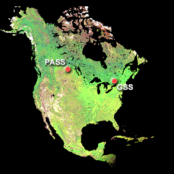
The Canada Centre for Remote Sensing has agreements with a number of international organizations to receive data from satellites while they are over North America. Data can be received at one or both of the CCRS's receiving stations: Prince Albert Satellite Station in Saskatchewan and Gatineau Satellite Station in Quebec.
Station Coverage

The transmission of data to the CCRS receiving stations occurs only when a satellite is within "line of sight". Using these two stations, most of North America is covered.
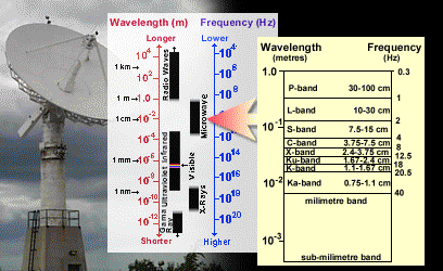
Transmission Bands
Remote sensing satellites typically use a small part (approximately 8.02 to 8.4 GHz) of the X-band for downlinking of Earth observation data. This "raw" or "signal" data will eventually be used to produce imagery.
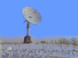
CCRS Antennas
At each of the CCRS receiving stations there are two antennas, each with a 10 metre diameter reflector. The large diameter allows for better reception of even weak signals.
Concrete Base: elevates and stabilizes the antenna and contains prime power panels and heat.
Base Extension: further elevates the antenna and houses the power amplifiers.
Tilt Mechanism: permits 2.5 degrees of tilt to enable antenna to track near-zenith passes.
Elevation over Azimuth Pedestal: principal mechanism for pointing the antenna in elevation (vertical angles) and azimuth (horizontal angles).
Counterweights: balances the weight of the 10m reflector and feeds.
Downconverters: convert the data stream from the incoming X and S-bands (8GHz and 2GHz), to 375 MHz.
Reflector: 10m diameter, paraboloid made up of 24 solid-surface reflector panels made of spun aluminum; the reflector surface is heated to prevent the accumulation of ice and snow.
Sub-Reflector: a dichroic, meaning that it's partly reflective (for X-band frequencies that are reflected onto the X-band feed) and partly transmissive (for S-band frequencies); it is positioned at the focal point of the paraboloid.
X-band Feed: receives the focused X-band signal and contains Low Noise Amplifiers and filters to remove unwanted frequencies.
X-band Feed Extension: positions the X-band feed to receive the X-band portion of the signal as it is reflected from the dichroic sub-reflector.
Aircraft Warning Lights: to warn approaching aircraft of the presence of the antenna.
Lightning Rod: to re-direct lightning strikes away from sensitive equipment.
Antenna Control
To record the data transmitted by the satellite, the receiving antenna must follow and continually point directly at the satellite. How is this done?
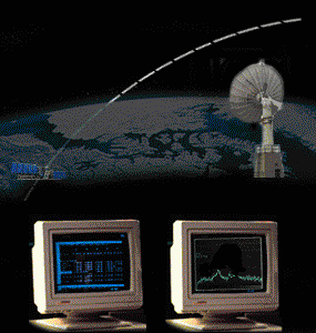
2.5.1. Ephemeris data (tables of the predicted location of the satellite) are used to aim the antenna at the expected location (azimuth and elevation) of the satellite as it appears over the horizon.
2.5.2. A computer moves the antenna, following along the predicted orbit of the satellite and searches for its X-band transmission. If a transmission is detected and if the signal is strong enough, the computer will track the satellite, using the X-band signal, rather than the ephemeris data.
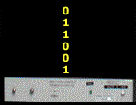
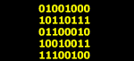
Data Stream Handling
|
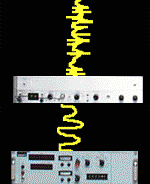
Original to intermediate frequency
The original X-band data at approximately 8GHz are received and converted by the "downconverters", located within the antenna structure, to an intermediate frequency of 375 MHz. Intermediate to 'raw' digital dataThe intermediate data stream are then converted into two different data streams (comprised of data and clock synchronization) by a "bit-synchronizer" housed within the station building computer facility. The resulting information is stored on special digital recording systems. Computer-readable dataThe digital data stream from a digital recording system is passed through a "frame synchronizer", which prepares the data in "image" form. The data is now fully compatible for conventional computer manipulation. The digital image data are then stored on any type of computer storage medium, such as exabyte tape or compact disk. |
Recording
Data Archive
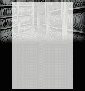 Every year, the Canada Centre for Remote Sensing collects and archives 30 terabytes of satellite imagery. As of March 2000, this has added up to a total of 275 terabytes!
One terabyte is equal to:
- 1,024 gigabytes, or
- 1,048,576 megabytes, or
- 1,073,741,824 kilobytes, or
- 1,099,511,627,776 bytes.
How much is that? Well, if you can put about 640 megabytes of data onto one compact disk (CD), then it would take 430,000 CDs to store all the information the CCRS archive has collected so far. If you placed those CDs side by side, then they would span 51.6 km. That's about the distance from Charlottetown to Summerside, or from Dorval airport to St. Hubert, or from North Vancouver to the Gulf Islands. If you stacked those 430,000 CDs on top of each other (don't try this at home!), it would reach the approximate height of the CN tower. In other words, that's a LOT of data!
Satellite Data Reception Conclusion
For further information on Satellite Data Reception at the Canada Centre for Remote Sensing, see:
- Ground Systems Operations Section
- Satellites that CCRS receives data from
Permission for Use
This tutorial is provided as is and may be copied in any form and used for non-commercial purposes provided that the content of the original material is not altered and it is clearly indicated that the Canada Centre for Remote Sensing, Natural Resources Canada is the originator of this material.