
It takes only seconds to protect yourself in an earthquake
By the end of 2024, more than 10 million people in Canada’s most earthquake-prone regions will be able to receive Earthquake Early Warning (EEW) alerts, giving them precious seconds to protect themselves.
April 2024
Did you know there are more than 5,000 earthquakes in Canada every year? Only about 50 of them result in the ground shaking vigorously enough to be noticed, and even fewer result in damage. But when the shaking is serious, it can be dangerous.
Imagine receiving a few seconds’ warning before earthquake shaking occurs. With this information you could quickly drop, cover, and hold on. Automatic safety measures could be implemented for critical infrastructure such as bridges, rail lines and hospital operating rooms. That’s the vision behind Canada’s national Earthquake Early Warning (EEW) system, being launched in British Columbia this spring and in Ontario and Quebec later this year.
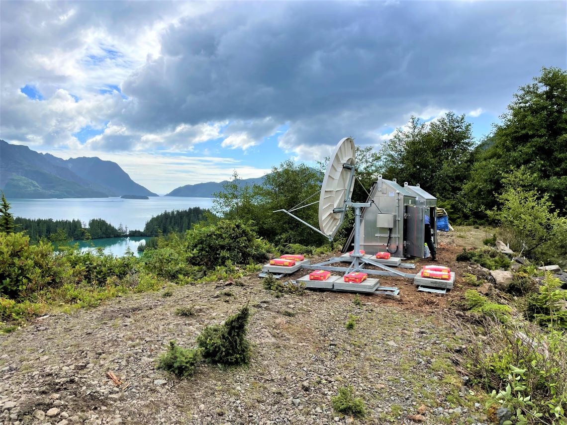
An EEW station installed on Haida Gwaii, an archipelago off the northern Pacific coast. Due to the remote location, the station is powered by solar panels, with back-up batteries, and data are sent to NRCan via satellite.
“The national EEW system will give advance warning of a few seconds to tens of seconds,” says Alison Bird, an earthquake seismologist with Natural Resources Canada (NRCan). “It doesn’t sound like a lot of time, but it’s enough to protect lives and potentially reduce damage.”
She’s part of a team of scientists and technicians who have developed the EEW system for at-risk regions of the country. The EEW system is composed of regional networks with over 400 seismic sensors, and uses advanced, automated software, and the latest technologies to estimate quickly how much shaking an earthquake might cause and automatically send out alerts to warn of impending shaking.
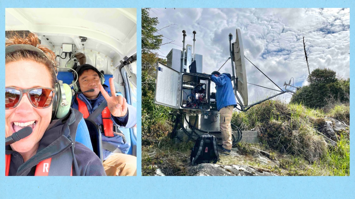
NRCan's Lisa Nykolaishen and Mingzhou Li have installed EEW stations in B.C.'s North Coast region where several stations are accessible only by helicopter. The field teams work hard in some of the most beautiful landscapes across Canada.
Historic megathrust earthquake
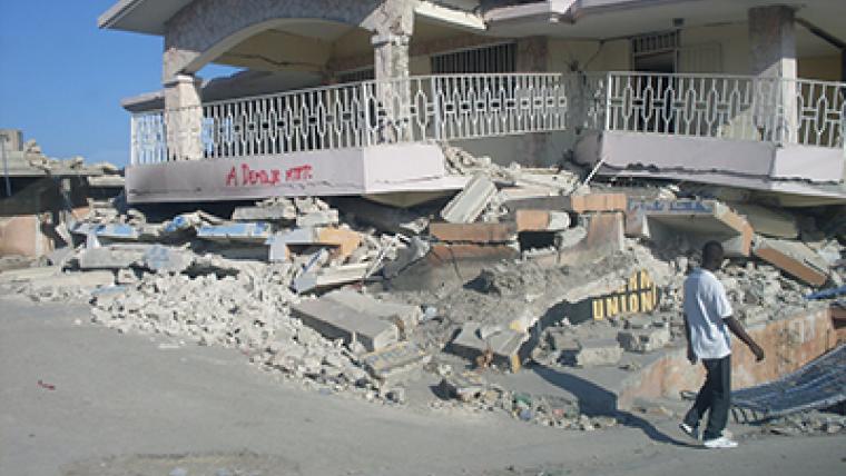
To understand how valuable Canada’s EEW system might be, go back to January 27, 1700. That’s when a powerful magnitude nine (M9) megathrust earthquake ruptured roughly 1,000 kilometres of the Cascadia Subduction Zone along the Pacific coast, running from mid-Vancouver Island to northern California. It generated immense shaking, landslides and a huge tsunami. Indigenous knowledge tells us that it changed the way First Nations in the region planned their communities, with many of them moving their communities inland, away from the shoreline.
When we fast forward some 300 years, this same area is now home to millions of people, with many living in waterfront communities. The built environment now has numerous tunnels and bridges and ferries and shipping vessels that regularly move through busy waterways. If a megathrust earthquake happened along the Cascadia Subduction Zone today, the results would be devastating.
There is a greater likelihood, however, of experiencing other types of strong damaging earthquakes elsewhere in this region: within the North American Plate, on which we live; within the subducting Juan de Fuca Plate; and along other major faults, such as the Queen Charlotte Fault off the west coast of Haida Gwaii. For all earthquakes in this region, the EEW alert would provide seconds to tens of seconds of warning.
How does an EEW system work?
Earthquakes release energy that travels as seismic waves through the Earth’s surface in all directions, in a manner similar to sound waves or ripples on a pond. The first waves are primary P waves. They travel quickly and are followed by the secondary S waves, which are slower and generally much more damaging.
The sensors — each about the size of a shoebox — will detect the first P-wave energy to radiate from an earthquake and then instantly transmit a signal to the data centres. The system uses software from the United States Geological Survey (already proven in California, Oregon and Washington) to analyze the seismic data to determine the location and magnitude of the earthquake. The system also estimates how intense the ground shaking might become in the region. The sensors can detect significant earthquakes so quickly — within a few seconds — that alerts can reach many people before the S-waves arrive.
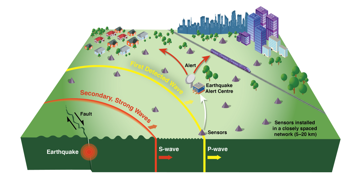
Earthquakes release energy that travels through the earth as seismic waves. Seismic sensors detect the first energy to radiate from an earthquake, the primary or P-wave, which rarely causes damage. The sensors transmit this information to data centres where a computer calculates the earthquake’s location, its magnitude and the expected ground shaking across the region. This method can provide seconds to tens of seconds of warning before the arrival of secondary S-waves, which bring the strong shaking that can cause most of the damage.
Automated alerts could help to protect hundreds of people
A few seconds is enough time for people to drop, cover and hold on or, if they’re driving, pull over and apply the parking brake. The benefits of the EEW could potentially protect hundreds, or even thousands of people from injury. “With this EEW system, critical infrastructure operators can have technologies in place whereby the alert automatically triggers protective actions,” says Alison.
Signals could prompt infrastructure safety systems to take action automatically, such as:
- triggering trains to slow down
- stopping traffic from driving onto bridges or into tunnels
- diverting incoming air traffic
- alerting surgeons to pause surgery
- closing gas valves
- opening fire hall and ambulance bay doors
Recent earthquake warnings in action
An EEW system introduced in Japan has effectively reduced potential injuries and damages during recent earthquakes. For example, in a 2022 earthquake near Tōhoku on the island of Honshū, rail lines were badly damaged, but the trains —triggered by the local EEW to stop — didn’t derail, and the hundreds of people travelling on them were safe.
More recently, on January 1, 2024, a magnitude 7.6 earthquake struck Noto, Japan, causing violent shaking and severe damage. Again, the EEW system there prompted trains to halt and sent public alerts to cell phones, TVs, and radios.
Canada’s earthquake zones, not just the West Coast
In Canada, most earthquake risk is concentrated along the B.C. coast, which is on the Ring of Fire, a highly active seismic and volcanic region running around the edge of the Pacific Ocean, including Chile, New Zealand, Japan, Canada, the western United States and Mexico. It’s where most major earthquakes and volcanic activity occur.
If you live elsewhere in Canada, that doesn’t mean you’re out of danger. “There are significant seismic risks that exist along the Ottawa River valley up through Montreal and the St. Lawrence Seaway,” says Alison. “Earthquakes in these regions might not register as high on the magnitude scale, but they can cause significant damage, especially to older masonry structures and poorly reinforced structures. Also, because the crust is denser in the east, the seismic waves retain their strength over greater distances, and as a result they impact a greater area.”
While earthquakes are often associated with Canada’s West Coast, other zones are vulnerable, primarily in eastern Ontario and along the St. Lawrence River in Quebec. The EEW system’s coverage is therefore concentrated in these regions.
It’s not a matter of if, but when
Being prepared to take action in a cool, calm and collected manner will be crucial for EEW to be effective. “The whole idea is not simply to alert people, but to ensure they know the best course of action to take,” says Alison. “In stressful situations, it can be hard to think clearly, and too often it becomes a fight or flight situation as people exit buildings,” she adds. “Which is one of the worst things you can do in an earthquake. By practising the drop, cover and hold on technique, like during October’s ShakeOut earthquake drill, people create the muscle memory that should take them to a safe space during an earthquake.”
Many earthquakes in B.C., eastern Ontario and southern Quebec occur close to populated centres, which means the warning time for the nearby locations might be only a few seconds. As a result, it might not be possible for the warning to arrive before the strong shaking begins in areas very close to the earthquake’s epicentre; places in this situation are said to be within the Late Alert Zone.
When an alert is received depends on several factors including the distance from the earthquake and how the alert is received. The farther you are from the epicentre, the more warning time you will have. But no matter when you receive an alert, it’s best to assume that shaking is imminent and take immediate protective actions.
Looking to the future:
A small, dedicated team at NRCan has been working on this system, with the help of provincial, territorial and municipal governments, First Nations, critical infrastructure operators, and other enterprises, such as BC Ferries.
If you live in one of Canada’s earthquake zones and receive an EEW alert, remember this: drop, cover and hold on until all the shaking stops.
Explore:
Related stories

Page details
- Date modified: