
December 2019
A trio of Earth observation satellites launched in June 2019 is providing Canadians with a more detailed picture of our country and oceans than ever before.
Known collectively as the RADARSAT Constellation Mission (RCM), these satellites mark a significant upgrade to Canada’s RADARSAT program. And by using a new imaging technology assessed and recommended by Natural Resources Canada (NRCan), RCM images provide scientists with more information to better understand our planet.
A 24-year legacy
Currently, RADARSAT data is used by more than 12 government departments to deliver important services to Canadians in three main areas: maritime surveillance, disaster management and ecosystem monitoring. It covers everything from monitoring foreign ships and mapping sea ice in the North, to monitoring changes in the Earth’s surface that put infrastructure at risk, to providing vital information about floods and oil spills to first responders.
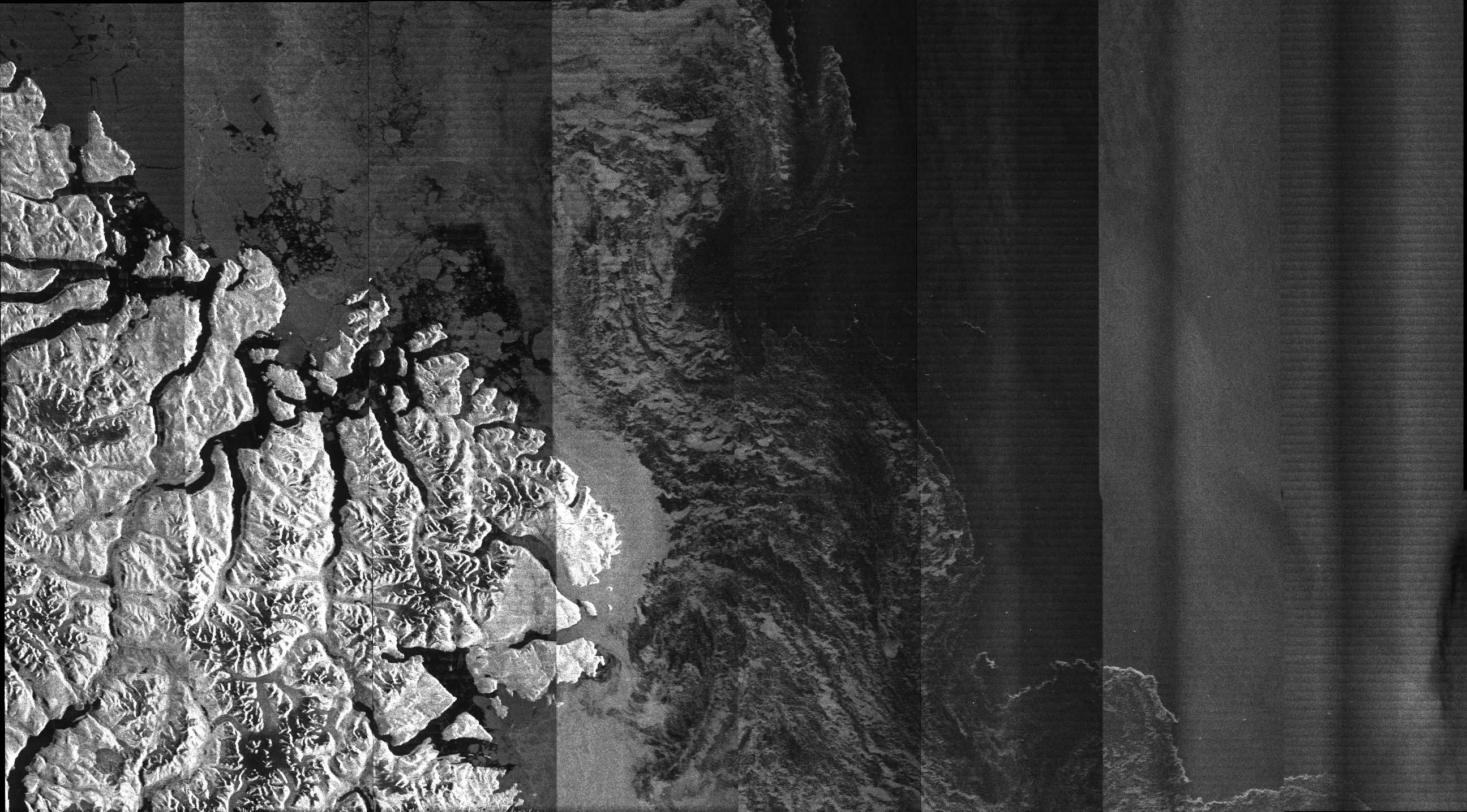
A recent RCM image of Baffin Island (the vertical bands indicate that the image still requires final processing). RADARSAT is an official trademark of the Canadian Space Agency (Copyright of the Government of Canada 2019 — All Rights Reserved).
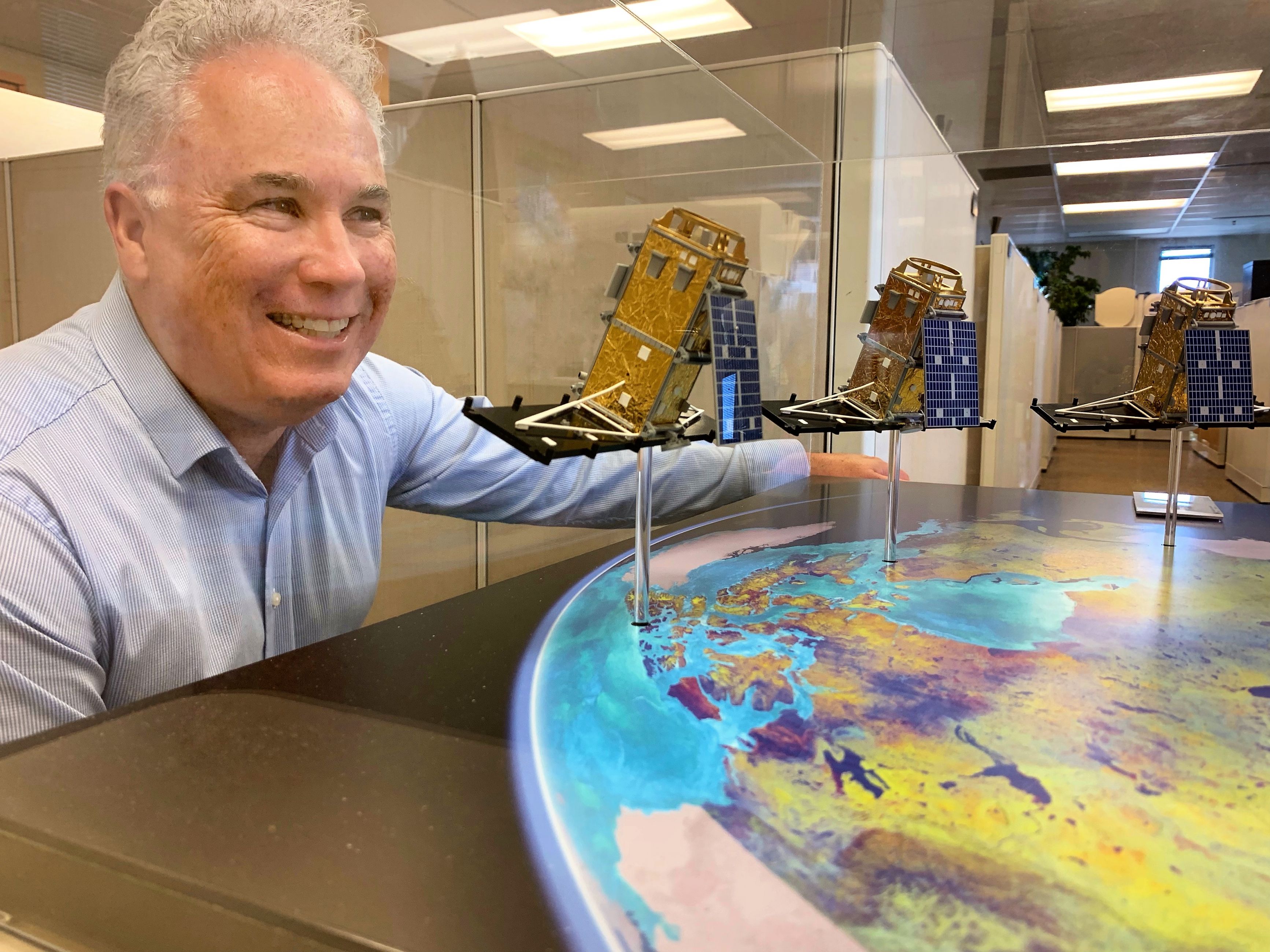
Roger De Abreu with a model of the satellites that he helped develop.
The RCM is the third mission of the RADARSAT program, which officially launched in 1995 with RADARSAT-1 and continued in 2007 with RADARSAT-2, which the RCM is now replacing. This new generation of satellites will continue and expand on our ability to monitor our country and its coastal areas.
Canada has invested in radar satellites in the RADARSAT program because they can image the earth’s surface at any time, day or night, and through all conditions, such as smoke, clouds or any other type of weather.
This function is crucial. “When you’re in a business where surveillance is critical, you can’t wait for the clouds to disappear,” says Dr. Roger De Abreu, head of the radar section at Natural Resources Canada’s (NRCan) Canada Centre for Mapping and Earth Observation, which develops new applications for radar satellites.
“When you’re looking for oil spills, when you’re trying to sense sea ice conditions, when you’re trying to monitor a flood, you need to see the surface when you need to see the surface,” he says.
“Things we’ve never seen before”
Learn more about NRCan’s role in the RMC project in this Simply Science YouTube video.
Transcript
Every day, the Government of Canada uses radar satellites to monitor Canada’s waterways, natural and human made hazards and to assess the effects of climate change and resource development on the environment.
Radar satellites have the unique ability to create images of the Earth’s surface at night or during cloudy weather — an ideal tool for a large polar nation such as Canada. Ground stations across the country control, collect and distribute the data.
Radar imaging isn’t new. In the 1970s, Natural Resources Canada scientists experimented with radar for Earth observation by mounting sensors on aircraft.
Since then, our scientists and satellite ground stations have supported the development and operation of Canada’s first Earth observation satellite, RADARSAT-1, which was launched in 1995.
It was replaced in 2007 by the RADARSAT-2 satellite, which is still operational.
Today, Natural Resources Canada is proud to partner with the Canadian Space Agency and other government departments on the RADARSAT Constellation Mission. The mission will launch and operate Canada’s next generation of radar satellite: a constellation of three smaller satellites.
The RADARSAT Constellation is actually three identical satellites that share monitoring duties, allowing us to image the same precise location more frequently.
These new satellites will allow us, for the first time, to capture images anywhere in Canada on a daily basis, ensuring that the Government of Canada continues to have the data it needs to support critical operations and research.
Natural Resources Canada’s science and technology have led to the addition of a new imaging mode called Compact Polarimetry to the RCM.
This new mode enables users to gather better, richer information over larger areas than previous RADARSAT missions.
Natural Resource Canada has also made sure that government, industry and academic users will be ready to make use of RADARSAT Constellation data.
Our scientists created software that allowed users to practise using RADARSAT-2 imagery. Using these tools, users could refine and enhance their systems as needed in advance of the launch, so they would be ready to use RADARSAT Constellation data as soon as possible.
We also upgraded our satellite ground stations to be prepared to receive much higher volumes of data and to support ground-to-satellite communications for the satellite launch, imaging activities and satellite maintenance.
We also improved users’ access to data by expanding our radar data archives and developed a portal through which users can access RADARSAT Constellation data and — for the first time — request pre-processed radar images that will be easier to interpret and use.
Natural Resources Canada’s contributions to the RADARSAT Constellation Mission build on Canada’s long legacy of leadership in using radar for Earth observation and help to ensure that this vital technology continues to provide critical information that serves Canadians every day.
“The RCM is a game changer,” says Roger. “We’re going to see things we’ve never seen before.”
That’s because one of the biggest upgrades is the fact the RCM is a constellation, or network, of three identical satellites rather than just one, like the RADARSAT-2 satellite it’s replacing.
Using three satellites means the RCM can revisit and image the same location much more often. The RCM can now provide imaging of anywhere in Canada at least once a day or up to three or four times a day in the North, whereas RADARSAT-2 can only monitor an area once every two to three days. That greatly improved ability enables the RCM to provide far more data to researchers and industry, compared with prior RADARSAT missions.
“That’s a big difference when you’re monitoring something like a flood or oil spill,” says Roger.
The use of three satellites also represents a significant upgrade since they can back up each other in case one goes off line. “We’ve always been quite aware that with RADARSAT-1 or RADARSAT-2, having only one satellite in space — if that fails, we really don't have any backup,” he says. “With a three-satellite constellation we really have a much more robust system.”
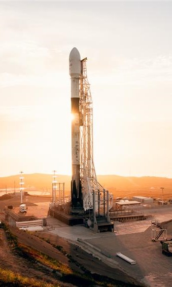
The three RCM satellites ready for launch by a SpaceX Falcon 9 rocket (© Canadian Space Agency).
The RCM also incorporates new, innovative technologies. It features an imaging mode called compact polarimetry (CP), which was added at the recommendation of NRCan radar scientists to significantly increase the amount of information for monitoring large areas in Canada.
More information means more practical applications of the imaging data. NRCan scientists will use the RCM to better understand and monitor geohazards such as landslides, volcanoes and earthquakes, as well as floods, forests, glaciers, ice, permafrost and coastal erosion.
An eye in the sky? Not exactly …
Radar satellites work differently than the optical satellites that provide photographic imagery, such as those used in Google Earth. Basically operating as a camera in space, an optical satellite records the sunlight that reflects off the surface. Since it works similarly to your eye, an optical satellite can’t record images at night, when there is no sunlight, or during the day if the surface is obscured by clouds.
Radar satellites like the RCM, on the other hand, create their own energy rather than relying on sunlight. They send down carefully controlled bursts of electricity and then accurately measure the amount and characteristics of the energy that bounces back, producing a much more detailed and content-rich image.
With the successful launch of the RCM behind them, Roger and his radar team are already working with the Canadian Space Agency in planning for the next mission in 2026.
What does it take to activate the RCM? Find out in this Simply Science podcast.
Find out more: