
Applying Duplex Wave Migration (DWM) and Seismic Modelling Technology to Delineate Steam Assisted Gravity Drainage process Steam Chambers and Reduce CO2 Emissions
Lead Proponent: TetraSeis Inc.
Location: Calgary, Alberta
ecoEII Contribution: $1,178,625
Project Total: $1,763,810
Project Background
In the Athabasca Oil Sands region of Alberta, bitumen deposits are commonly found in the McMurray Formation. Where the McMurray outcrops near the surface, and it can be extracted using surface mining techniques. However, if the McMurray is deeper than 75 meters, an in-situ method called Steam Assisted Gravity Drainage (SAGD) must instead be used. SAGD operations require the drilling of horizontal wells into which hot steam is injected to melt the bitumen out. This method causes much less surface damage than surface mining. However, energy intensity is much higher, primarily due to the excessive use of natural gas to produce steam. If more accurate data on the time-lapse properties of SAGD zones along injecting and producing horizontal wells were made available, energy intensity could be reduced.
Conventional 4D seismic (time lapse) methods used for SAGD allow operators to see only the top view of the SAGD zone. Since SAGD zones have an elongated and irregular shape which, when fully developed, becomes a "mushroom" in cross section, the top view does not provide accurate information on the location and side boundaries. Recognizing the challenges to SAGD operations, TetraSeis proposed the project "Applying Duplex Wave Migration (DWM) and related Seismic Modelling Technology to Delineate Steam Assisted Gravity Drainage (SAGD) process Steam Chambers and Reduce CO2 Emissions" for ecoEII funding. The Program awarded TetraSeis $1,178K for the Project.
Results
DWM/SDWM (Scattered Wave Duplex Wave Migration) are patented seismic data processing methods that enable imaging of near vertical structures (such as hydrocarbon reservoirs) located below the surface. The capability of DWM/SDWM to generate maps of SAGD melt zones in order to identify less depleted areas of a reservoir was assessed. Baseline 2009 and time-lapse 2012 seismic surveys from the Leismer study area (where an oil sands facility is in operation) were used to produce associated data cubes. The data cubes contained images of SAGD zones, and were used to interpret SAGD melt zone boundaries and to compute their reflection coefficients. Maps of temperature, oil saturation and oil viscosity were derived using TetraSeis’ interpretation software (DWMINT). It was determined that the use of DWM/SDWM to produce high-resolution reservoir property maps that accurately delineate the location and boundaries of SAGD melt zones could improve SAGD steaming operational efficiency by 10 to 20%.
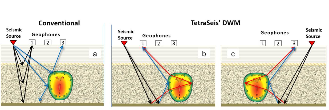
Figure 1. a: Conventional 4D Top view; b: Right side view DWM; c: Left side view DWM
Text version
In case of conventional 4D seismic reflection methods (1a), we can only image sub-horizontal features from above. Therefore, conventional imaging technology can only see the top of the SAGD zone which is often much wider than the actual SAGD melt zone width due to: 1) the spreading of the steam effects at the cap rock interface, 2) incomplete migration apertures / insufficient far offsets, and 3) amplitude calibration to temperature. Note that for the kinematics of conventional single bounce imaging the reflection from the side of the SAGD melt zone does not return to the surface, and therefore the side of the SAGD zone is invisible to conventional imaging technology.
In the case of duplex reflection (b & c) for relatively thick objects, reflections from both front side (blue rays) and back side (red rays) sub-vertical boundaries of the object can be imaged. In addition, DWM must be separately illuminated from one side of the object to avoid overlapping images. Both Right and Left side views are still useful, yielding 2 data volumes and 4 reflection measurements.
The ability to directly detect the side boundaries of the SAGD melt zone is of great importance because it enables the direct interpretation not only of where they are located in space but also by measuring their amplitudes we can compute an estimate of the key reservoir property, temperature, at each side boundary. Also, the fact that the duplex seismic wave travels through the SAGD melt zone and is reflected from the back side of the SAGD melt zone means that we can measure the energy decay effects that occurred inside the zone. These measurements provide us with a method to characterize the changing conditions inside the SAGD melt zone along the horizontal well. This ability to directly detect the side boundaries is due to the fact that the DWM technology simulates a seismic experiment that has been undertaken with the sources on the base boundary, whereas, conventional seismic imaging can only directly detect reflections from the top of the SAGD melt zone and the side boundaries are invisible to conventional imaging technologies.
The capability of DWM/SDWM to map relative variations in bitumen pore fill intensity was also assessed. Numerical seismic modeling experiments were conducted. Baseline 2009 seismic survey from the Leismer study area was used to produce associated data cubes which contained seismic images that reflect the heterogeneity of bitumen in the oil sands formation. It was concluded that although comparison with reservoir productivity data indicated that DWM is likely capable of identifying areas of high bitumen concentration, further investigation involving comparative studies with drilling results would be required.
Lastly, the use of DWM/SDWM for early detection of cap rock failure was investigated. Loss of cap rock integrity (fractures) could allow heavy oil and various chemicals to escape into fresh water aquifers and possibly to the surface. Baseline 2009 and time-lapse 2012 seismic surveys from the Leismer study area were used to produce associated data cubes. The data cubes contained seismic images of the oil sands’ cap rock and formations above the cap rock. Two zones of changes in seismic properties were identified, possibly due to the effect of heat. Nonetheless, they did not indicate cap rock failure and no linear fracture features were found. It was therefore concluded that the cap rock in the study area had maintained its integrity and successfully contained heated liquids and gases inside the reservoir.
Benefits to Canada
Ability to accurately delineate SAGD steam chambers and map melt zone development could reduce energy cost and associated greenhouse gas (GHG) emissions, as well as improve the Steam to Oil Ratio (SOR) and operational efficiency at SAGD sites in Canada.
Next Steps
TetraSeis intends to promote the use of its DWM/SDWM technology. Furthermore, the technology may be adapted in the future for use in detecting low throw faults and fractures which if left unnoticed could rupture to the surface and contaminate the surrounding environment.
Page details
- Date modified: