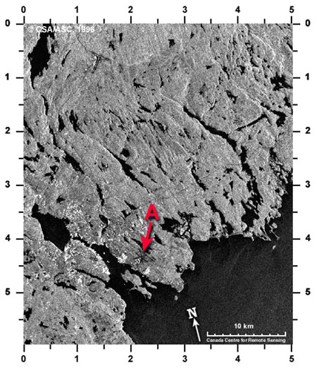
Measure this (Halifax area)
Instructions: In the RADARSAT image of the Halifax area, the letter A is pointing to Shearwater airport. You can see the dark criss-crossing lines which are the airport runways. They are dark because on the ground they are smooth, just like the water bodies nearby (ocean at the bottom right and the many inland lakes). The many buildings in Halifax and nearby reflect the radar beams well, giving lots of bright spots on this image.

Halifax
Find another airport in this image. The runways will be similar in appearance but not exactly in the same pattern. The other airport is at:
A: (1.6, 5.4)
B: (4.0, 2.6)
C: (3.9, 0.9)
D: (1.4, 0.7)
If you were flying from this other airport towards the ocean, you would be travelling:
A: south
B: south-west
C: north-west
D: west
Can you see any roads in this image? One road is located at:
A: (1.7, 2.7)
B: (1.2, 5.8)
C : (1.0, 1.2)
D: (4.0, 3.6)
The inner part of Halifax harbour is at 0.7, 3.9; the straight line distance from here to Devil's Island at 2.8, 5.1 is about:
A: 6 km
B: 16 km
C: 7 km
Page details
- Date modified: