
A Combined Classification Algorithm
Both unsupervised and supervised methods described above have their weaknesses. For the H / A /  -classification, the thresholds are somewhat arbitrary and not the entire polarimetric information can be used due to the inability to determine all four angles that parameterize the eigenvalues. The Bayes minimum relies on a training set or initial clustering of the data. However, each algorithm overcomes some of the shortcomings of the other.
Therefore, a combination of the two algorithms seems attractive  . An improved classification can be obtained by first applying the H / A / unsupervised classifier to set up and cluster 16 initial classes, followed by the minimum distance classifier based upon the distribution of clustered parameters. The distribution can be taken from the complex Wishart distribution, and iterations can be used to optimize the class separation boundaries , , .
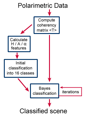
Figure 7-5: Combined Entropy / Anisotropy / ![]() - minimum distance classifier
- minimum distance classifier
The combined algorithm is outlined in Figure 7-5. It can be viewed as an unsupervised algorithm, as the initial classification is unsupervised. However, as the iterations refine the cluster means and boundaries, the final classes should be scrutinized and assigned labels based upon a physical interpretation. Note that while the initial clustering is made in the H / A / domain, the minimum distance classification is performed using the coherency matrix directly. After the Bayes classification, the clusters may overlap in the H / A / domain. The classifier results do depend upon the number and diversity of classes input to the Bayes classifier, so it is always useful to experiment with different initial classes.
An example of the results of the combined H / A/ Bayes classification algorithm is given in Figure 7-6. Four sea ice types, three water classes and four land classes have been extracted from an April 1994 SIR-C image off the west coast of newfoundland . The level of detail of the extracted ice types is an indication of the power of computer classification of polarimetric radar data.
Classification algorithms can include a segmentation algorithm in which neighbouring pixels that have common characteristics are grouped together prior to the assignment of classes. If done properly, segmentation can significantly improve the classification results .

Did you Know?
that many classification algorithms are in use and more are still being developed, because the success of the algorithms are very dependent upon the sensor characteristics, and even upon the scene content? Some of the common tools developed include the method of principal components, maximum likelihood estimation (MLE), optimal Bayesian methods, maximum a posteriori estimation (MAP), clustering methods, neural networks, minimum distance and parallelepiped methods and Markov random fields.
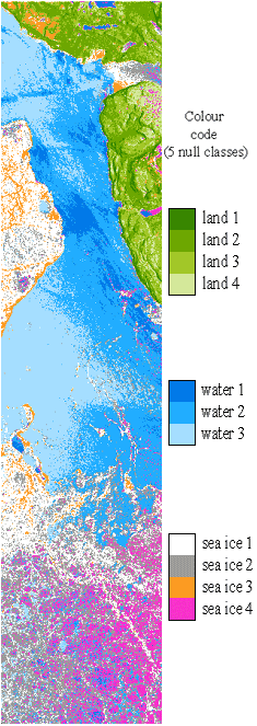
Figure 7-6: Classification of land, ocean and ice types from a SIR-C polarimetric C-band scene off the West coast of newfoundland .
Page details
- Date modified: