
Coastal zone applications
The coastal zone is a physically dynamic and ecologically sensitive environment which is subject to a variety of anthropogenic pressures (urban growth, industrial development, tourism) and natural (climatic induced) events resulting in significant coastal erosion. It is often densely populated and is a region of commercial, industrial, and recreational activity. It is an important environment to be monitored and managed effectively for sustainable use. Coastal applications that may benefit from the use of polarimetric SAR data include shoreline mapping, (in support of coastal change mapping) and substrate mapping (environmental sensitivity mapping/habitat mapping). The following sections provide examples of how multi-polarization or polarimetric data might help with these applications.
- Shoreline Detection
- Substrate Mapping
Shoreline detection
The extraction of shoreline information from SAR imagery is possible due to the large contrast between backscatter from the water and from the land: If the water is relatively calm, it acts as a specular reflector (low backscatter) and this contrasts well with land that typically has higher backscatter. The delineation of shorelines can become more difficult due to wind induced surface roughness on the water which reduces the contrast between the water and land at the interface between the two. At moderate to high wind conditions and at shallow incidence angles, the microwaves interact primarily with the surface capillary waves resulting in increased backscatter as the surface roughness increases. This is particularly true for imagery in the VV polarization where poor contrast occurs between wind roughened water and land. Imagery in the HH and HV polarizations shows less sensitivity to wind induced surface roughness. Figure 9.44 (imagery in VV) shows high backscatter due to wind induced sea surface roughness and a relatively low water-land contrast. In the HH image, the backscatter from the sea surface is lower than that in the VV image although the surf results in a zone of higher backscatter along the shoreline. The image in the HV polarization shows the best contrast between land and water. Polarimetric data can be used to produce imagery with maximal contrast [ ] between selected features. This is seen in the sharp boundary between land and water in Figure 9.44d.
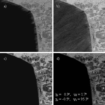
Figure 9-44. Water and land contrast as a function of polarization a) HH, b) VV, c) HV, d) maximum contrast image (Courtesy of CCRS).
Substrate mapping
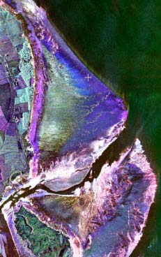
Thematic maps of tidal and near-shore terrestrial areas provide a basis for coastal zone sensitivity assessment and for other applications such as military reconnaissance mapping. Imagery in a single polarization is generally inadequate for discriminating coastal zone features. Multi-polarization or polarimetric imagery can be used to effectively discriminate the structural differences of various coastal features. Figure 9.46 shows an inter-tidal flat in the Minas Basin of the Bay of Fundy. The tidal flat is gently sloping (1 to 2°) and consists of friable sandstone, mudflats and gravel and boulder deposits along the channel. In the multi-polarization colour composite, regions corresponding to various substrates can be separately identified. The green tone associated with the area of sandstone indicates the dominance of the cross-polarized return that is typically associated with volume or multiple scattering. The mud flats show a very low backscatter return in images in the HH and HV polarizations, while the gravel and boulder deposits (white) are indicative of high backscatter return seen in imagery at all three of the polarizations.
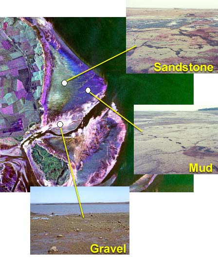
Figure 9-46. RGB composite (R-HH, G-HV, B-VV) of tidal flat at Evangeline Beach, NS from CV-580 C-SAR data. Note: backscatter contrasts in the dry land area and the tidal plane were enhanced independently (Courtesy of CCRS).
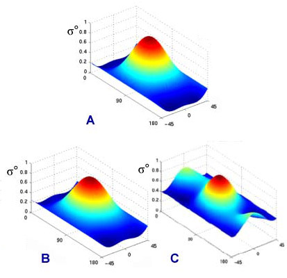
Polarimetric signatures for regions of different substrates within the tidal zone are shown in Figure 9-47. Each signature shows that backscatter is maximal at the VV polarization The mud flats exhibit a very low pedestal height (0.03), and the higher pedestal heights for sandstone and gravel suggest an increase of the unpolarized component due to rough surface scattering. A more prominent backscatter return in the HH polarization is evident in the area of the gravel/boulder substrate indicating significant double bounce scattering.
 = Normalized
Figure 9-47. Polarimetric signatures for tidal zone substrates (Courtesy of CCRS). Surface types are (a) mud (b)sandstone and (c) gravel.
9.6.2.1 Polarimetric classification
 Did you Know?
The type of substrate along a coastline is important for environmental reasons such as susceptibility to erosion, oil spill remediation and habitat evaluation, as well as for military applications such as suitability as a landing site with respect to trafficability.
Polarimetric classification according to scattering mechanism may provide additional useful information regarding target characteristics within tidal zones. Figure 9-48 shows a simple classification of the tidal flat using the method outlined by van Zyl (1989). It classifies the dominant scattering behaviour of each pixel into one of three scattering classes: Odd Bounce scattering, Even Bounce scattering, or diffuse scattering.
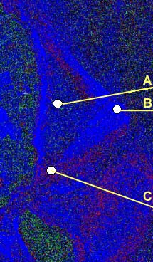
A = Sandstone B = Mud C = Gravel
Red = Even (double)
Green = Diffuse
Blue = Odd
Figure 9-48. Unsupervised classification of scattering mechanisms (Courtesy of CCRS).
The classification results show that mud flats within the tidal zone are predominantly surface scatterers (Odd Bounce) characteristic of a smooth to slightly rough surface, sandstone areas are predominantly characterized by Odd Bounce scattering with a mix of Even Bounce and diffuse scattering. The gravel areas tend to have a high portion of Even Bounce scattering due to the presence of small boulders that act as corner reflectors.
Whiz quiz
 Question: Why is imagery in the cross polarization better than that in VV for identifying the land/water boundary? The answer is...
Whiz quiz - answer
Answer: Water is a surface scattering target with a very low backscatter at HV compared to land thus resulting in better land-water contrast. Also the VV polarization is more sensitive to wind induced surface roughness resulting in lower contrast between land and water.
Page details
- Date modified: