Appendix C: Using coordinates
One convenient and precise way to point to a certain spot on a picture (or a map) is by the Cartesian Coordinate method. A series of numbers (or sometimes letters) on the edge of the picture lets you identify a spot without having to put some reference mark inside the picture.
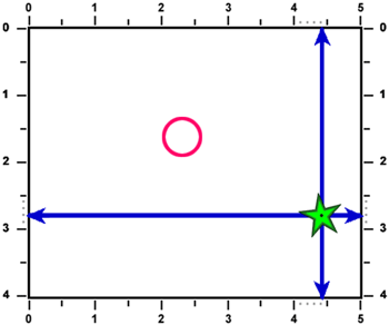
If we want to talk about a feature such as a lake, road or field in a satellite image and we don't want to mark up the image itself, then we can use two numbers to identify the spot. The first number is always the horizontal distance and the second number is always the vertical distance.
In the example here, the star has a horizontal coordinate of 4.4 and a vertical coordinate of 2.8, and they are often written as: (4.4, 2.8). Use a straight edge like a ruler or a piece of paper to line up the numbers. Make sure the straight edge is exactly parallel to the edge of the image. This can be done by connecting the same number (4.4 in this example) on both the top and the bottom scale. Do the same for the second number by lining up the same number (2.8 in this example) on both the left and right scales.
To see if you can do this, try to find the coordinates of the centre of the circle in the diagram. They are: ( ______, _______ )

Page details
- Date modified: