Find it!
Instructions:
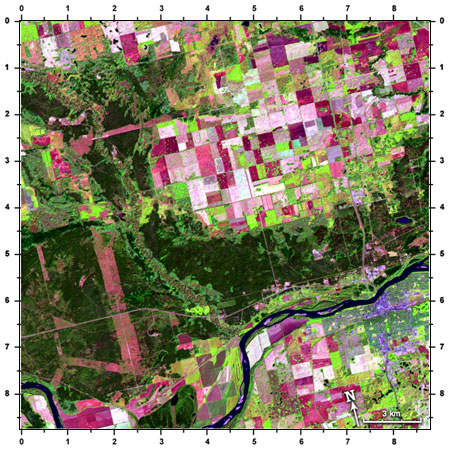
In this Landsat satellite image of northern Saskatchewan, we see farm fields (pink and white and light green rectangles), forests (dark green), the town of Prince Albert (blue/purple), and the North Saskatchewan River (dark blue). The colours are strange because we are using information from parts of the spectrum that we don't normally see (like the infrared) and are showing them as colours that we do see. Lets find some more features in this image! Use the number coordinates on the edge of the image.

Find it!
The town of Prince Albert is located at:
A: (5.5, 8.0)
B: (5.6, 3.2)
C: (7.7, 6.1)
D: (9.8, 11.4)
The field located at: (3.2, 2.6) is the same colour (and therefore is of the same material) as the field at:
A: (5.2, 2.6)
B: (4.7, 3.7)
C: (5.3, 1.1)
There is a long, meandering river which flows into the image at location: 0.0, 1.2. It is too narrow to see the water, but you can see the vegetation on the riverbanks. It joins (flows into) the North Saskatchewan River at:
A: (6.9, 6.1)
B: (4.8, 6.7)
C: (8.2, 5.3)
There is a lake in the middle of the forest at:
A: (8.2, 4.2)
B: (9.3, 9.8)
C: (2.2, 2.5)
The field at (5.4, 3.2) has several green dots in it. These are "sloughs" or small ponds surrounded by grasses and weeds. The water is too small to see in most cases but the vegetation shows as green. Another location of sloughs is at:
A: (1.9, 5.3)
B: (5.0, 7.0)
C: (1.7, 8.5)
D: (5.7, 8.0)
In the North Saskatchewan River are many islands. Some are without vegetation (pink/white) and some have grasses and shrubs (light green). One of these vegetated islands is at:
A: (4.4, 8.6)
B: (5.5, 6.4)
C: (7.5, 7.5)
D: (0.8, 7.7)
Which road runs north-south? It is the one at:
A: (1.6, 6.4)
B: (4.0, 7.3)
C: (2.0, 2.4)
D: (5.3, 5.0)
Page details
- Date modified: