The UTM Grid - Military Grid Reference System
Two systems are marked on National Topographic System (NTS) maps for identifying points with reference to the rectangular grid: Civilian UTM Grid Reference System and Military Grid Reference System described below.
Please read this note regarding an error in Military Grid references on NTS maps.
To begin with, if there is no possible confusion about the map sheet on which the reference falls, the Military Grid Reference System provides a very quick and easy method of referencing. The topographic maps carry a rectangular grid with numbers in the margin identifying the horizontal and vertical lines. On large-scale maps (1:50 000 and larger) each number consists of two digits as shown below:
The map reference

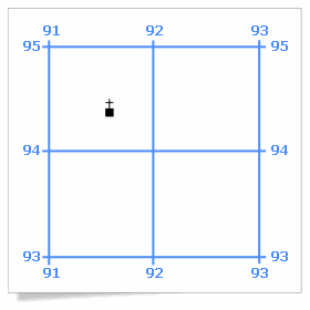
Figure 1 - The UTM grid
Figure 1 - Text version
Figure 1 is an illustration of a church superimposed over a UTM grid which makes it possible to obtain the map reference.
To arrive at a map reference for the church shown in Figure 1, we would first note the numbering of the lines that form the west and south of the square. For centuries, mathematicians have given the X coordinate before the Y coordinate; map users follow suit by quoting eastings before northings. Therefore the designation of the square containing the church would be 9194.
To give a reference for the church itself, we must imagine the square divided into 100 smaller squares (ten by ten). Then we estimate by eye that the church is six tenths of the way between lines 91 and 92, and four tenths of the way between lines 94 and 95. Using these figures, we can quote the easting as being 916 and the northing as 944. By convention these are combined into a reference of 916944.
The use of a roamer

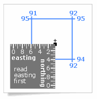
Figure 2 - Using a roamer on a UTM grid
Figure 2 - Text version
Figure 2 is an illustration of a roamer which consists of a small transparent card graduated with units of the appropriate scale.
A roamer is a small transparent card graduated with units of the appropriate scale. Using a roamer allows even more precision as shown in Figure 2. With the roamer, the reference can now be given as 91559435. Note that the reference always has an even number of digits, the first half representing the easting, the second half the northing.
A unique referencing

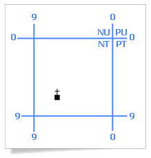
Figure 3 - 1:250 000 UTM grid
Figure 3 - Text version
Figure 3 is an illustration of reference numbers in blue which makes the unique referencing.
The Military Grid Reference System is convenient, but unfortunately reference numbers repeat themselves every 100,000 metres (100 km or about 62 miles). Therefore a method has been devised to identify the 100,000-metre squares by letters which are printed in blue on the face of all NTS maps. This is particularly important in the case of medium- and small-scale maps (1:250 000 and smaller), as unlettered references are ambiguous on a single map. The identifying letters (two of them) are always given before the numbers. Figure 3 shows a reference on a 1:250 000 map (where grid lines are usually identified by a single number).
Here the church would be in square NT99 and more precisely at point NT9293. This reference is still not unique, but the same reference does not occur again for about 2,900 km (1,800 miles). For most purposes this is sufficiently unambiguous.
If, for some reason, a reference is required that is unique in the world, one must look in the margin of the map for the Grid Zone Designation. The zone, which is explained elsewhere, is one of the 60 strips of the projection. The zone number is followed by a letter which gives the general area north or south of the equator in bands of 8 degrees. Therefore the unique designation of the church if it were in the Ottawa area would be 18 T NT9293.
This material updated from The Universal Transverse Mercator Grid, Department of Energy, Mines and Resources Canada, Surveys and Mapping Branch, Ottawa, © 1969, The Queen‘s Printer.
MGRS Identification Letter Corrections
Many National Topographic System (NTS) map sheets have been produced with the wrong two letter MGRS designators. Our NTS sheets show the Military Grid Reference System, commonly known as the 100 000-metre square identification grid. Each 100 000-meter square is identified by a combination of two alphabetical letters. Starting at the 180° meridian and proceeding east along the equator, each 100 000-metre column is lettered alphabetically, from A through Z, with I and O omitted. Starting at the equator and proceeding north, each row is lettered alphabetically, from A through V, with I and O omitted. Reading from south to north, this lettering system is repeated every 2 000 000 metres.
In the late eighties, Natural Resources Canada decided to use the North American Datum of 1983 (NAD83), instead of the North American Datum of 1927 (NAD27), as the official datum for our mapping activities. When this change of datum occurred, we were instructed to change the lettering system for the 100 000-metre square identification grid on map sheets produced under the new datum. In the process, because of an error introduced in the lettering system, the wrong letters were shown on newly revised map sheets.
To help you understand what topographic maps are and how to use them, see National Topographic System (NTS) and The basics (PDF, 1.34 MB).
Find out more
- Map Projections
- Universal Transverse Mercator Projection
- Rectangular Grid References
- Civilian UTM Grid Reference
- Military Grid Reference System - US Defense Mapping Agency's Technical Manual 8358.1
Page details
- Date modified: