Blow me down
- Abrupt or isolated hill or headland rising steeply from the water and subject to sudden down-drafts of wind
- Common in Newfoundland and Labrador, usually simply as "Blow Me Down"
- Some related terms: hill, head, cape, cliff, bluff
- In French: promontoire (m.)
- Examples:
- Bay of Islands Blow-Me-Down, N.L., 49° 04' - 58° 17' (12 G/1)
- Blow Me Down, N.L., 49° 31' - 55° 09' (2 E/11)
Brandies
- Partly submerged rocks; a reef
- Originated from the word "brandise", an iron tripod used for cooking (in Ireland); probably originally used to refer to a group of three rocks. Usually "The Brandies".
- Used only in Newfoundland
- Some related terms: rock, reef
- In French: rochers (m.)
- Example:
- Change Brandies, N.L., 49° 42' - 54° 24' (2 E/9)
Buffalo jump
- Vertical side of a coulee, hill, or river bank
- Place where Plains Indians killed herds of bison by driving them over steep cliffs
- Used in Alberta, but rare
- Some related terms: bank, cliff, bluff, escarpment
- In French: escarpement (m.)
- Example:
- Head-Smashed-In Buffalo Jump, Alta, 49° 43' - 113° 39' (82 H/12)
Canyon
- Deep narrow valley with precipitous walls
- This generic term is widely used across Canada
- Western examples are mainly gorge-like with fast-flowing watercourses
- In early days, canyon was used in the Spanish form "cañon"
- Some related terms: valley, ravine, gorge, trench, coulee
- In French: canyon (m.)
- Examples:
- Bowdoin Canyon, N.L., 53° 34' - 64° 16' (23 H/9)
- Roaring River Canyon, Man., 51° 52' - 101° 13' (62 N/14)
- Maligne Canyon, Alta., 52° 55' - 118° 00' (83 D/16)
- Grand Canyon of the Stikine, B.C., 58° 07' - 130° 38' (104 J)
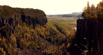
((Source: H. Kerfoot))
Cone
- Cone-shaped hill
- Used in Newfoundland, Labrador and British Columbia. A few in B.C. (e.g. Cinder Cone) are young volcanic vents
- Related terms: hill, sugarloaf, tolt, pingo
- In French: colline (f.)
- Examples:
- Vargas Cone, B.C., 49° 05' - 125° 52' (92 F/4)
- Hayes Cone, N.L., 56° 41' - 61° 10' (14 C/11)
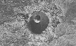
((Source: National Air Photo Library, A12788-421; 1950.))
Cratère
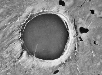
- More or less rounded, bowl-shaped depression
- A cratère can be either volcanic or meteoric in origin
- Used in Quebec.
- In English: crater
- Example:
- Cratère des Pingualuit, Que., 61° 17' - 73° 40' (35 H/5)
Échouerie
- Blocks of flat rock extending into the sea
- In Canadian French, the term "échouerie" means a place where herds of seals and walruses rest, whereas in international French it refers to a place where vessels might go aground
- Descriptive term used in Quebec
- In English: ledge
- Example:
- La Grande Échouerie, Que., 47° 22' - 61° 52' (11 N/5)
Gulch
This generic term can have several different meanings
(1)
- Deep, steeply graded, V-shaped valley, sometimes containing a stream
- Generally smaller than a ravine but larger than a gully
- The generic is widely used, but is particularly of note in the gold mining areas of the Yukon in the late 1890s
- Related terms: ravine, valley, gorge, pup
- In French: ravine (f.)
- Examples:
- Grub Gulch, B.C., 53° 02' - 121° 42' (93 H/4)
- Gold Bottom Gulch, Y.T., 63° 54' - 138° 59' (115 N & O)
- Bears Paw Gulch, Man., 49° 39' - 98° 53' (62 G/10)
- Arch Gulch, N.S., 45° 21' - 64° 52' (21 H/7)
(2)
- Narrow cove with steep shoreline
- Used in Newfoundland and Labrador
- Related terms: cove, bay, hole
- In French: anse (f.)
- Examples:
- Guys Gulch, N.L., 49° 33' - 53° 49' (2 F/12)
- Bear Gulch, N.L., 49° 44' - 56° 48' (12 H/10)
(3)
- Saltwater channel
- Used in Nova Scotia
- Related terms: passage, narrows, channel, pass, gut
- In French: goulet (m.)
- Example:
- Camp Island Gulch, N.S., 44° 53' - 62° 09' (11 D/16)
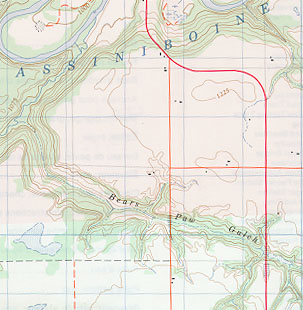
((Source: NTS map 62 G/10))
Mal bay
- Tidal pond almost completely cut off from the sea by a bar
- Used in New Brunswick, but rare
- Related terms: lagoon, barachois, pond
- In French: barachois (m.)
- Example:
- Windsors Mal Bay, N.B., 47° 57' - 64° 29' (21 P/15)
Oxbow
- A horseshoe-shaped loop, either part of or detached from a meandering watercourse
- Used in New Brunswick, Ontario and Manitoba, but uncommon
- Related terms: bend, elbow
- In French: boucle (f.), but no examples of this generic term are found in Canadian geographical names
- Examples:
- Lower Oxbow, N.B., 45° 34' - 65° 01' (21 H/11)
- Maxwell Oxbow, Man. 49° 57' - 97° 38' (62 H/13)
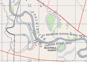
((Source: NTS map 62 H/13))
Pingo
- Isolated, conical, ice-cored mound occurring in areas of permafrost
- Use is limited to the N.W.T., and includes some seabed examples in the Beaufort Sea
- Related terms: hill, mound, knoll, cone
- In French: as this term is of Inuit origin, the word "pingo" would remain the same
-
Examples:
- Ibyuk Pingo, N.W.T., 69° 24' - 133° 05' (107 C)
- Kugmallit Pingos, (seabed - Beaufort Sea), 70° 45' - 132° 40'
(see Canadian Hydrographic Service chart 7651)
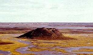
((Source: H. Kerfoot))
Plée
- Area of land devoid of trees
- "Plée" would seem to be the noun derived from the adjective "pelé" (devoid of vegetation) or else a phonetic variant of the term "prée" (f.) used in French-speaking areas of the Maritime Provinces for "pré"
- Used in Quebec
- Related terms: champ, pré
- In English: meadow
- Example:
- Grande plée Bleue, Que., 46° 46' - 71° 03' (21 L/14)