Introduction - British Columbia
1.1 ORGANIZATION OF THIS CHAPTER
This chapter provides an overview of climate change impacts and adaptation issues in British Columbia, with an emphasis on recent and ongoing work leading to adaptation action. The impacts of, and adaptation to, climate change in British Columbia will vary across the province's diverse landscapes, communities and socioeconomic activities. Available information covers the breadth of issues unevenly, with research being abundant on some topics (e.g. water resources and fisheries) and very limited for others (e.g. energy and transportation). Available information also focuses strongly on the impacts of climate change, although adaptation is becoming a more significant element of recent studies.
This introduction provides a broad overview of BC's physical and human landscapes, and briefly summarizes some key adaptation challenges in different regions of the province. Section 2 discusses drivers of climate variability in BC, and examines historical trends and future projections of major biophysical indicators of climate change. In Section 3, the implications of these biophysical changes are discussed in the context of adaptation to multiple stressors within key economic sectors. Greater detail on selected regional issues is presented in Section 4 as integrated case studies, highlighting the general trend from impacts research towards adaptation action. The concluding section of the chapter presents a synthesis of common themes, key insights and lessons learned from materials presented in the preceding sections.
1.2 CLIMATE AND PHYSICAL GEOGRAPHY

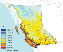
FIGURE 1: Annual mean temperature in British Columbia 1961-1990 PRISMFootnote 1 average. The PRISM numerical method interpolates station observations to a 4 km grid considering physical factors such as slope aspect and elevation . The PRISM model is considered more robust in areas with higher density of data collection stations and at elevations near the stations (Daly et al., 2002).
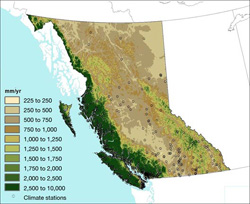
British Columbia is the most physically and biologically diverse region in Canada. The proximity of the Pacific Ocean and presence of several major mountain chains significantly influence BC's climate and ecosystems (Valentine et al., 1978). On the coast, mild, moist Pacific air encounters the steep Coast Mountains to produce a humid, maritime climate with annual air temperatures above 5 °C and total annual precipitation exceeding 1000 mm (Figures 1 and 2). Some of the warmest climates in Canada occur in BC's southern coast and interior regions. The south-central BC coast has a warmer and drier climate in the rain shadow of Vancouver Island. The driest and warmest climates of BC (semiarid steppe) occur in the rain shadows of the Coast and Cascade ranges, and in the valleys of the southern interior west of the Columbia Mountains.
A humid continental climate predominates in central and southeastern BC. The Rocky Mountains restrict westward flow of cold Arctic air from the Prairies, moderating winter climate in the region. The Interior Plateau underlies most of this area and is the main catchment area for the Fraser and Columbia rivers. The climate of northern BC is controlled by the influx of cold Arctic air, the intensity of the continental high-pressure system, and inflow of warm dry air in the summer. This produces subarctic and boreal climates with very cold winters and short mild summers. This region is a complex landscape of mountains and plateaus that grade northeastward into the Great Plains. Average annual precipitation is low (less than 500 mm) in the interior plains and valleys, increasing to greater than 1000 mm along the coast and in the mountains. Three major river systems, the Peace, Liard and Skeena rivers, occupy this landscape.

FIGURE 2: Annual total precipitation in British Columbia from 1961-1990 PRISM (see Figure 1) average. The wettest climates in Canada occur on BC's coast, especially on mountain slopes of Vancouver Island, the Queen Charlotte Islands and the mainland Coast Mountains.
Coastal British Columbia has a cool, moist, maritime climate influenced by the northeastern Pacific Ocean. In winter, midlatitude cyclonic storms move ashore and bring abundant precipitation to much of the coast. Variations in winter climate result from changing frequency and intensity of coastal storms. In part, this is due to the position of the prevailing storm track and the intensity of major low-pressure systems, such as the Aleutian Low. In summer, a subtropical high-pressure system moves northward in the northeastern Pacific, and storms are less frequent and approach the coast farther north. Variability in BC's climate is responsive to changes in the intensity of these oceanic pressure systems, which in turn are associated with changing ocean temperatures and currents. As such, variability in most of BC's climate is connected to large-scale ocean-atmospheric phenomena, namely the El Ni ño–Southern Oscillation (ENSO) and the Pacific Decadal Oscillation (PDO; see Section 2.1 and Chapter 2).
1.3 BIOGEOGRAPHY AND ECOLOGICAL DIVERSITY

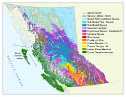
FIGURE 3: British Columbia's 14 biogeoclimatic zones (after Pojar and Meidinger, 1991)
British Columbia can be divided into 14 biogeoclimatic zones (Krajina, 1965; Pojar and Meidinger, 1991; Hebda, 1998), distinguished by climate, latitude, elevation and distance from the coast (Figure 3). This biogeoclimatic classification system is used widely for both planning and research purposes (e.g. Mitchell et al., 1989; Hamann and Wang, 2006). Biodiversity varies within and between zones, although there are generally more species in the south and/or at lower elevations. In some regions, such as mountainous areas of southern BC, as many as six biogeoclimatic zones supporting thousands of species can be encountered across distances of only a few kilometres.
Local disturbances, such as fire, insects, disease, windthrow and human activity, significantly influence species distributions. Some disturbances, such as mountain pine beetle outbreaks, are exacerbated by climate change (see Section 4.2). Ecosystem responses to future climate change will be localized and depend on both natural and anthropogenic factors, including species sensitivity, the severity of the climate change and features that inhibit or enable species migrations, such as urban sprawl and the presence of migration corridors.
1.4 HUMAN ENVIRONMENT
The ability of British Columbia's communities and economic sectors to respond and adapt to climate change will depend as much on social and economic characteristics as it will on location and climate. Eighty-five per cent of British Columbians live in urban areas, mainly within the regions of greater Vancouver and Victoria, but also in several ‘regional hubs' that include Kelowna-Vernon, Kamloops, Prince George and Prince Rupert. Rural BC consists of many smaller towns and First Nations communities dispersed along the coast and in the interior. The social and cultural landscape of BC is changing in many ways in response to local and global economic shifts, urbanization trends, immigration and technology. Climate change will influence and affect these communities differently.
The historical mainstay of BC's economy is the extraction, processing and export of natural resources, mainly wood, fish and minerals. Over the past 15 to 20 years, the contribution of natural resources to BC's economy, relative to total production and employment income, has declined in response to various environmental, social and economic changes (see Section 3). Traditional patterns of development and the relationship between major urban centres and rural regions are beginning to change in response to globalization and other factors (Matthews and Young, 2005). Despite this ongoing transformation, natural resources continue to dominate provincial exports and remain especially vital to the social and economic health of rural BC (Baxter and Ramlo, 2002; BC Ministry of Labour and Citizens' Services, 2004b).
Recent demographic trends in BC have been driven by urbanization and immigration. The province has the second highest immigrant population in Canada after Ontario (Statistics Canada, 2001). Population in 2005 was 4.25 million, and is projected to reach 5.6 million by 2031 (BC Ministry of Labour and Citizens' Services, 2005a; Statistics Canada, 2005). Growth is concentrated in the Greater Vancouver Regional District (+8.5%), the Okanagan region (+8.2%) and the Squamish-Lillooet Regional District (+12.3%)Footnote 2. In contrast, some northern and coastal districts, such as northern Vancouver Island (–10.2%) and the Skeena–Queen Charlottes (–12.5%), have experienced recent population declines (Statistics Canada, 2001). In part, this reflects out-migration spurred by job losses in resource-dependent communities and the general economic downturn in remote and rural communities during the past 10 to 15 years (Marchak et al., 1999; Hayter, 2000; Baxter and Ramlo, 2002; Matthews, 2003; Hanlon and Halseth, 2005; Young, 2006a, b).
The historical tendency in BC for broad swings across the political spectrum between successive elections has had both positive and negative effects on adaptive capacity at the community scale. Restructuring of rural and resource development policy and the delivery of services to remote communities has led many communities to become ‘entrepreneurial risk takers' (Young 2006a, b), and to assume a greater role in local resource management, community development and service delivery (Young, 2006a, b; Matthews and Young, 2007; Ommer, 2007). For small communities with limited adaptive capacity, dealing with such short-term issues limits their ability to simultaneously prepare for, and adapt to, a changing climate (Brenner and Theodore, 2002; Herbert-Cheshire and Higgins, 2004). Another key factor that will affect future adaptation in British Columbia is the pending changes in jurisdiction and responsibility for future land- and resource-use management and planning that will occur as treaties are eventually signed between First Nations and the governments of Canada and BCFootnote 3. These changes will have important, although as yet undetermined, implications for adaptation, especially in coastal and rural regions of the province.
1.5 REGIONAL CHALLENGES
The impacts of climate change and the approaches to adaptation will vary across British Columbia's disparate regions and economic sectors (see Section 3).
About 75% of BC's population lives in the Vancouver–Lower Mainland region, where both the population and the economy have greatly diversified in recent decades. The communications technology, entertainment (especially film production), light industry, greenhouse agriculture, biotechnology, construction, retail and service sectors have all become major elements of the regional economy, joining more established sectors such as tourism, transport and port functions (Vancouver Economic Development, 2006). Currently, the region is investing heavily in infrastructure for the 2010 Winter Olympics and to support continued growth and development over the next few decades. Managing growth within the objectives of the official ‘Liveable Region Strategic Plan' (Greater Vancouver Regional District, 1999) will require consideration of, and planning for, climate change. The Victoria Capital Regional District (CRD), the political and administrative hub of the province, is also expected to see continuing population and economic growth. Current climate risks in both the Greater Vancouver Regional District (GVRD) and the CRD include water shortages associated with frequent droughts and the impacts of extreme weather events. These risks are expected to increase in the future, with significant implications for municipal infrastructure (see Section 4.4).
In northern and central BC, the current mountain pine beetle (MPB) outbreak exemplifies the linkages between climate change, natural pest cycles and resource management practices (see Sections 3.3 and 4.2). The initial response to the crisis was to increase harvest levels two to three times in an effort to secure the timber value of infected trees before they rot. The social and environmental consequences of both the outbreak and the response, although uncertain, are a concern for many interior communities. In areas most heavily infected, managing the current and anticipated impacts of the outbreak overshadows most other issues.
Northeastern BC is currently experiencing an oil and gas resource boom, which started in the 1990s and peaked in 2003 (Canadian Association of Petroleum Producers, 2005, 2006). The strong regional economy attracts workers from areas of high unemployment around BC and across Canada. There has been little study of the impacts of climate change in this corner of the province, although adaptation challenges are likely to be similar to those in adjacent parts of Alberta (see Chapter 7).
Communities along the north-central coast of BC have experienced significant social and economic change in the past 10 to 20 years, with many communities experiencing significant unemployment, social stress and depopulation (Matthews, 2003; Ommer, 2006; Young, 2006a, b). Communities along the southern coasts have faced similar challenges, although they are ameliorated partly by proximity to the major economic centres of Vancouver and Victoria. The future of coastal communities in light of climate change and other stressors will depend on economic diversification and renewal; as such, adaptation will be closely linked to regional development. Potential areas for diversification include tourism, community forests and aquaculture (BC Ministry of Environment, 1997a; Matthews and Young, 2005). Although all have their limitations, salmon aquaculture faces additional challenges due to the politically and ecologically contentious nature of current practices (BC Ministry of Environment, 1997b; Gardner and Peterson, 2003; Naylor et al., 2003; Morton et al., 2005; Gerwing and McDaniels, 2006; see Section 3.2).
Southeastern BC encompasses two subregions, unified by the central role of water supply in land-use and resource management decisions. The Okanagan valley has strong orchard industries and more than 90% of BC's wineries and vineyards (Northcote, 1996; BC Ministry of Labour and Citizens' Services, 1997, 2005c; Bremmer and Bremmer, 2004). The region has experienced rapid growth and development in the past twenty years, and now supports an established tourism sector and burgeoning retirement population (McRae, 1997). The region's water resources are already stressed, and future shortages will be exacerbated by climate change (Cohen et al., 2003, 2006; see Section 4.3). To the east, the Columbia-Kootenay region hosts much of the province's hydroelectric generating capacity. Climate change impacts on snow pack and glaciers will limit the quantity and alter the timing of water availability for power generation in the region. These changes will excacerbate the existing challenges for water managers of reconciling competing demands of domestic, agricultural, fisheries, industry and commercial users, as well as meeting obligations to partners in interprovincial and international agreements (Volkman, 1997; Smith et al., 1998)
Page details
- Date modified: