Glaciers
What is a glacier?
A glacier is a large body of ice that forms on land where the accumulation of snow and its densification into ice exceeds ablation (melting, sublimation and mechanical calving) over many years. Glaciers slowly deform and flow due to stresses caused by their weight.
Where are glaciers located?
Canada’s landmass and climate supports approximately 20% of the Earth’s glacier ice volume excluding the Antarctic and Greenland ice sheets. Outside of the ice sheets of Antarctica and Greenland, Canada has more glacier coverage in the form of mountain glaciers, icefields and ice caps than any other nation.
In Canada, glaciers and ice caps are found in the Arctic where they occupy ~150,000 km2 of the Queen Elizabeth Islands, Baffin Island, and Bylot Islands, and in the Western and Northern Cordillera region which supports ~50,000 km2 of glacier coverage.
Why monitor glacier change?
Sites in the Canadian Arctic Archipelago are monitored primarily as indicators of climate change and for their contribution to regional and global sea-level changes. Glaciers in this region have become the 3rd largest contributor to global sea-level rise Footnote 1 outside of the Antarctic and Greenland ice sheets. Run-off from glaciers in this region also impact local streamflow and freshwater fluxes into the Arctic Basin.
The Western Cordillera sites are monitored primarily as indicators of climate change and for their contribution to water resources and ecosystem functioning in BC, AlbertaFootnote 2, Yukon and the Northwest Territories, and freshwater fluxes into the Arctic Basin. Glaciers affect the seasonal timing of streamflow, important for communities and water-reliant sectors including hydroelectric power generation and mining.
How are glaciers measured?
Glacier mass balance has been recognized as an “Essential Climate Variable” by the World Meteorological Organization / Global Climate Observing System
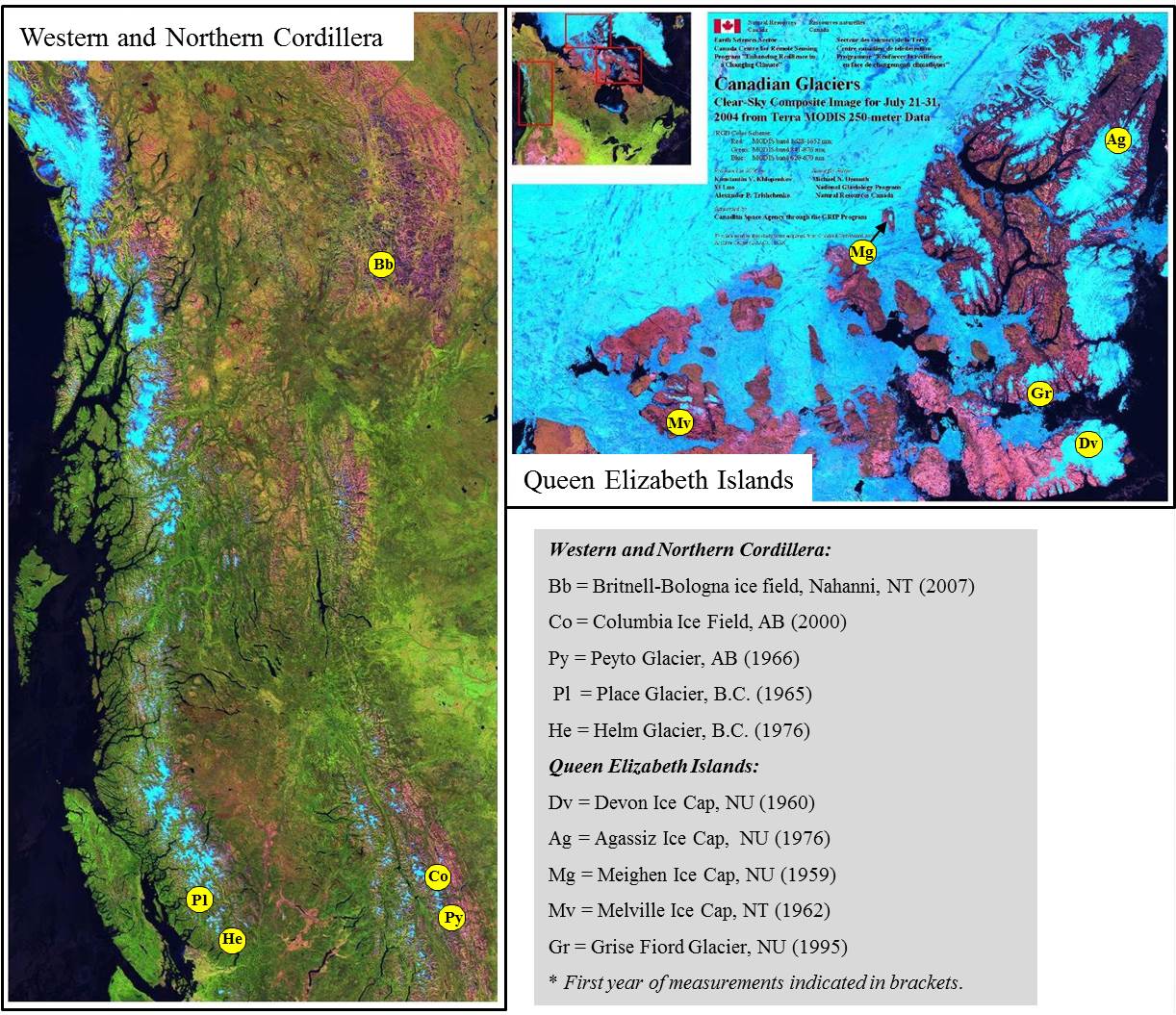
(https://www.wmo.int/pagesprog/gcos/index.php?name=EssentialClimateVariables) because it plays an important role in climate change surveillance, understanding sea-level change, and hydrology. NRCan-ESS’s Climate Change Geoscience Program monitors glacier mass balance at reference sites in the Western Cordillera and the Canadian Arctic Archipelago (see map below) with partners and researchers from other Canadian and international government departments and universities.
The key parameter derived from the annual glacier surveys is net surface mass balance (excludes mass loss due to ice-berg calving) which is the sum of ablation, or the total mass loss due to melt and run-off, and accumulation which is the total input to the glacier that comes primarily in the form of snow, but also includes rain. Ablation and accumulation are measured across glacier basins or ice caps using standardized methods as outlined in Ostrem and Brugman (1991). Field measurements of glacier mass balance are aided by the use of remote sensing instruments from space borne, airborne and terrestrial platforms, in concert with coordinated domestic and international efforts on the ground.

Locations of glacier mass balance monitoring sites maintained by the Government of Canada.
Text version
Western and Northern Cordillera: Bb = Britnell-Bologna ice field, Nahanni, NT (2007); Co = Columbia Ice Field, AB (2000); Py = Peyto Glacier, AB (1966) ; Pl = Place Glacier, B.C. (1965); He = Helm Glacier, B.C. (1976)
Queen Elizabeth Islands: Dv = Devon Ice Cap, NU (1960); Ag = Agassiz Ice Cap, NU (1976); Mg = Meighen Ice Cap, NU (1959); Mv = Melville Ice Cap, NT (1962); Gr = Grise Fiord Glacier, NU (1995)
* First year of measurements indicated in brackets.

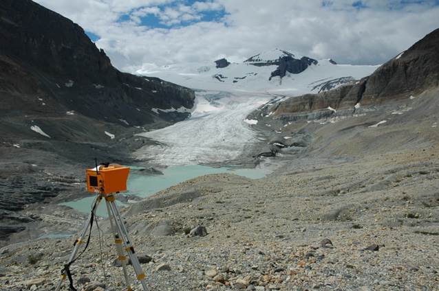
Terrestrial laser scanner used to produce high resolution digital elevation models of Peyto Glacier in Banff National Park, Alberta, Canada.

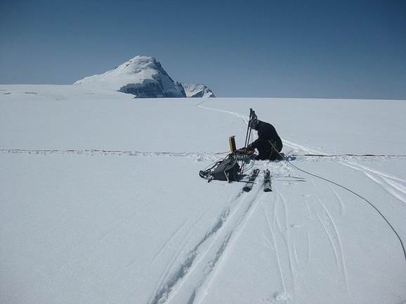
Ice Penetrating Radar surveys conducted by a Glaciology Research Scientist from the Geological Survey of Canada on the upper Columbia Icefield, Canadian Rockies. Mount Columbia (3,747 m) is in background.
References:
- Gardner and 15 others. Science, 340 (2013).
- Marshall and 7 seven others. Canadian Water Resources Journal 36(2): 109-134. (2011)
- Ostrem, G., and Brugman, M. Environment Canada, National Hydrology Research Institute (NHRI) Science Report 4, 224p. (1991)
- Shepard and 47 others. Science, 338 (2012).
Publications
Sample Publications
- Recent and past-century variations in the glacier resources of the Canadian Rocky Mountains: Nelson River system
- Cryosat delivers monthly and inter-annual surface height change for Arctic ice caps
Publications categories
Publications search
Use your own search criteria to discover more scientific publications.
Data Collections
Retrieve data related to:
You can search entire collection of geospatial data, topographic and geoscience maps, images and scientific publications.
Atlas of Canada Maps
Browse the following selected maps from the Atlas of Canada:
or explore other popular maps featured in the Atlas of Canada
Tools and Applications
Federal Programs
Page details
- Date modified: