
Data Reception, Transmission, and Processing
Data obtained during airborne remote sensing missions can be retrieved once the aircraft lands. It can then be processed and delivered to the end user. However, data acquired from satellite platforms need to be electronically transmitted to Earth, since the satellite continues to stay in orbit during its operational lifetime. The technologies designed to accomplish this can also be used by an aerial platform if the data are urgently needed on the surface.
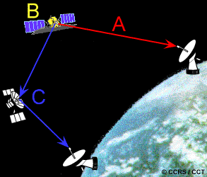
There are three main options for transmitting data acquired by satellites to the surface. The data can be directly transmitted to Earth if a Ground Receiving Station (GRS) is in the line of sight of the satellite (A). If this is not the case, the data can be recorded on board the satellite (B) for transmission to a GRS at a later time. Data can also be relayed to the GRS through the Tracking and Data Relay Satellite System (TDRSS) (C), which consists of a series of communications satellites in geosynchronous orbit. The data are transmitted from one satellite to another until they reach the appropriate GRS.
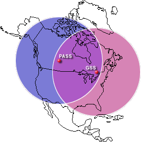
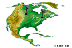
In Canada, CCRS operates two ground receiving stations - one at Cantley, Québec (GSS), just outside of Ottawa, and another one at Prince Albert, Saskatchewan (PASS). The combined coverage circles for these Canadian ground stations enable the potential for reception of real-time or recorded data from satellites passing over almost any part of Canada's land mass, and much of the continental United States as well. Other ground stations have been set up around the world to capture data from a variety of satellites.
The data are received at the GRS in a raw digital format. They may then, if required, be processed to correct systematic, geometric and atmospheric distortions to the imagery, and be translated into a standardized format. The data are written to some form of storage medium such as tape, disk or CD. The data are typically archived at most receiving and processing stations, and full libraries of data are managed by government agencies as well as commercial companies responsible for each sensor's archives.
For many sensors it is possible to provide customers with quick-turnaround imagery when they need data as quickly as possible after it is collected. Near real-time processing systems are used to produce low resolution imagery in hard copy or soft copy (digital) format within hours of data acquisition. Such imagery can then be faxed or transmitted digitally to end users. One application of this type of fast data processing is to provide imagery to ships sailing in the Arctic, as it allows them to assess current ice conditions quickly in order to make navigation decisions about the easiest/safest routes through the ice. Real-time processing of imagery in airborne systems has been used, for example, to pass thermal infrared imagery to forest fire fighters right at the scene.
Low resolution quick-look imagery is used to preview archived imagery prior to purchase. The spatial and radiometric quality of these types of data products is degraded, but they are useful for ensuring that the overall quality, coverage and cloud cover of the data is appropriate.
"...I'm receiving you loud and clear..."
... Canada's ground receiving stations have been in operation since 1972 in Prince Albert, Saskatchewan and 1985 in Gatineau, Quebec. These two stations receive and process image data from several different satellites (NOAA, Landsat, RADARSAT, J-ERS, MOS, SPOT, and ERS) from five different countries or group of countries (USA, Canada, Japan, France, and Europe).
Page details
- Date modified: