
Satellites and sensors
On the Ground, In the Air, In Space
In Chapter 1 we learned some of the fundamental concepts required to understand the process that encompasses remote sensing. We covered in some detail the first three components of this process: the energy source, interaction of energy with the atmosphere, and interaction of energy with the surface. We touched briefly on the fourth component - recording of energy by the sensor - when we discussed passive vs. active sensors and characteristics of images. In this chapter, we will take a closer look at this component of the remote sensing process by examining in greater detail, the characteristics of remote sensing platforms and sensors and the data they collect. We will also touch briefly on how those data are processed once they have been recorded by the sensor.
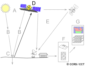
In order for a sensor to collect and record energy reflected or emitted from a target or surface, it must reside on a stable platform removed from the target or surface being observed. Platforms for remote sensors may be situated on the ground, on an aircraft or balloon (or some other platform within the Earth's atmosphere), or on a spacecraft or satellite outside of the Earth's atmosphere.
Ground-based sensors are often used to record detailed information about the surface which is compared with information collected from aircraft or satellite sensors. In some cases, this can be used to better characterize the target which is being imaged by these other sensors, making it possible to better understand the information in the imagery.
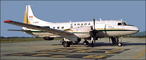
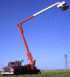
Sensors may be placed on a ladder, scaffolding, tall building, cherry-picker, crane, etc. Aerial platforms are primarily stable wing aircraft, although helicopters are occasionally used. Aircraft are often used to collect very detailed images and facilitate the collection of data over virtually any portion of the Earth's surface at any time.
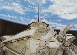
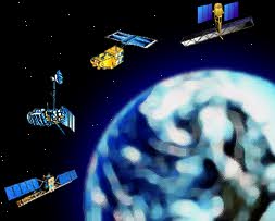
In space, remote sensing is sometimes conducted from the space shuttle or, more commonly, from satellites. Satellites are objects which revolve around another object - in this case, the Earth. For example, the moon is a natural satellite, whereas man-made satellites include those platforms launched for remote sensing, communication, and telemetry (location and navigation) purposes. Because of their orbits, satellites permit repetitive coverage of the Earth's surface on a continuing basis. Cost is often a significant factor in choosing among the various platform options.
Did you know?
- High wing aircraft are preferable to low wing aircraft for hand-held aerial photography.
- The 'drop hatch' in aircraft such as the DeHavilland "Beaver" and "Otter" are convenient to use for vertical aerial photography without performing aircraft structural modifications.
- Oblique aerial photography can preferably be done through an open window rather than through window glass/plastic.
- Photography through the aircraft door opening (having removed the door prior to flight) is also frequently done.
- Tethered balloons provide an inexpensive photography platform for long-term monitoring of a specific site.
Page details
- Date modified: