
Agriculture
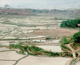
Agriculture plays a dominant role in economies of both developed and undeveloped countries. Whether agriculture represents a substantial trading industry for an economically strong country or simply sustenance for a hungry, overpopulated one, it plays a significant role in almost every nation. The production of food is important to everyone and producing food in a cost-effective manner is the goal of every farmer, large-scale farm manager and regional agricultural agency. A farmer needs to be informed to be efficient, and that includes having the knowledge and information products to forge a viable strategy for farming operations. These tools will help him understand the health of his crop, extent of infestation or stress damage, or potential yield and soil conditions. Commodity brokers are also very interested in how well farms are producing, as yield (both quantity and quality) estimates for all products control price and worldwide trading.

Satellite and airborne images are used as mapping tools to classify crops, examine their health and viability, and monitor farming practices. Agricultural applications of remote sensing include the following:
- crop type classification
- crop condition assessment
- crop yield estimation
- mapping of soil characteristics
- mapping of soil management practices
- compliance monitoring (farming practices)
Did you know?
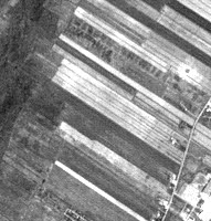
Fields in Quebec
Did you know that remote sensing of agricultural areas could give us clues about our heritage? In Québec, farmer's field shapes are very different than in Saskatchewan. In Québec, long thin strips of land extend from riverbanks, following French settlers' tradition. These types of fields are also visible in Nova Scotia, where the Acadians farmed, in New Brunswick, and in parts of Ontario. In the prairies, the fields are square and strictly follow the township and range plan.
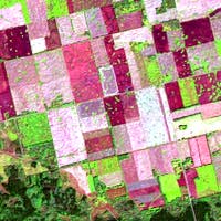
Fields in Saskatchewan
Whiz quiz
Crop Circles Seen from Space!
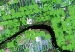
Every spring seems to bring a resurgence of the mysterious crop circles seen in farmers' fields around the world, often attributed to the work of aliens. Finally, these crop circles have been observed by a remote sensing device! Landsat TM captured this view while over southern Alberta. Look at the green circles on the image - how could they have been caused, other than by alien activity?
The answer is ...
Whiz quiz - answer
The "crop circles" are in fact, healthy crops irrigated using a pivot irrigation system - not the result of alien tricks. In the dry southern prairies, farmers rely on pivot irrigation systems to keep the crops watered and healthy. You can see that in the corners of the fields where the water fails to reach, the vegetation is missing or has suffered. The brownish grey areas in this image are primarily rangeland, while the crops appear green. Crops can be successfully grown if a regular irrigation routine is followed, but this puts a heavy demand on water resources in a typically dry area.
Page details
- Date modified: