Introduction - Prairies
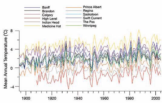
FIGURE 1: Trends in mean annual temperature since 1895 for 12 climate stations spread across the Prairies. The average increase in mean annual temperature for the 12 stations is 1.6°C. Source: Environment Canada, 2005.
Most climate models project the largest increases in mean annual temperature in the high latitudes of the Northern Hemisphere (Cubasch et al., 2001). Consistent with these projections, temperature records from the Prairies show significant positive trends, especially since the 1970s (Figure 1). The favourable consequences of this general warming, and higher spring temperatures in particular, are a warmer and longer growing season and enhanced productivity of forests, crops and grassland where there is adequate soil moisture.
Unfortunately, summertime drying of the earth's midcontinental regions is also projected, as greater water loss by evapotranspiration is not offset by increased precipitation (Gregory et al., 1997; Cubasch et al., 2001). Projections vary from slight (Seneviratne et al., 2002) to severe (Wetherald and Manabe, 1999) moisture deficits, depending mainly on the complexity of the simulation of land-surface processes. Elevated aridity has major implications for the Prairies, the driest major region of Canada. Recurrent short-term water deficits (drought) impact the economy, environment and culture of the Prairies. Seasonal water deficits occur in all regions of Canada, but only in the Prairies can precipitation cease for more than a month, surface waters disappear for entire seasons, and water deficits persist for a decade or more, putting landscapes at risk of desertification.
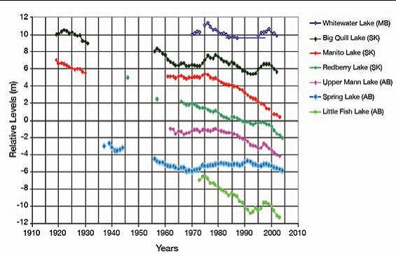
FIGURE 2: Historical water levels for closed basin prairie lakes Source: van der Kamp et al., 2006; van der Kamp and Keir, 2005.
Declining levels of prairie lakes (Figure 2) also suggest drying of the prairie environment. Closed-basin lakes are sensitive indicators of hydrological and climatic change (van der Kamp and Keir, 2005; van der Kamp et al., 2006). Fluctuations in lake levels can be related to land use and water diversions, but similar patterns for lakes across the Prairies implicate the influence of climate parameters, particularly rising temperatures, changes in the amount of snow (Gan, 1998) and changes in the intensity of rain (Akinremi et al., 1999), on the water budgets of these lakes.
The communities and institutions of the Prairies have considerable capacity to take advantage of higher temperatures and minimize the adverse impacts of climate change due to the relative abundance of financial, social and natural capital. Subregional disparities result, however, from strengths and weaknesses with respect to the determinants of adaptive capacity (Table 1). There are also key socioeconomic and environmental factors that underlie the vulnerability of the region to climate change. For example, the Prairies:
- are Canada's largest dryland, where seasonal and prolonged water deficits define the natural environment and strongly influence human activities;
- contain more than 80% of Canada's farmland, where production and landscapes are sensitive to climatic variability;
- rely on irrigation water from the Rocky Mountains, where the hydrology is expected to change with climate change;
- have a climate that, since European settlement, has not included the prolonged droughts of previous centuries;
- are projected to experience more severe drought under some climate change scenarios;
- require water for processing Canada's largest reserves of oil and gas;
- include some of Canada's fastest growing cities and economies; and
- have an Aboriginal population that is the most concentrated in Canada outside the northern territories and is the fastest growing segment of the region's population.
| Determinant | Strengths | Weaknesses |
|---|---|---|
| Economic resources | Major, especially in Alberta and urban centres | Remote rural communities lack economic diversification; individuals versus corporations (e.g. family versus corporate farms) |
| Technology | Alternative energy and greenhouse gas emission reduction technology | Less adaptation technology (e.g. water conservation) |
| Information and skills | Various climate change research programs associated with universities and government agencies | Cutbacks in climate- and water- monitoring programs; poor understanding of the social dimensions of climate change |
| Infrastructure | Well developed in populated areas; current designs that are addressing climate change (e.g. Winnipeg floodway); delays in upgrading and replacing infrastructure provide opportunities to consider future climate | Vast area (e.g. Saskatchewan has more roads than any other province; Nix, 1995); deficits from budget constraints in the 1990s |
| Institutions | Engaged in building capacity and assessment of vulnerability (e.g. Alberta Vulnerability Assessment; Davidson, 2006; Sauchyn et al., 2007) | Focus on mitigation; only beginning to develop adaptive strategies |
| Equity | Social programs | Health impacts on more vulnerable populations: First Nations, rural communities and especially remote settlements, elderly and children |
Although the Prairies are only about 25% prairie, they are known to Canadians as the 'Prairies'; therefore, that terminology is adopted here. When this chapter refers to the prairie ecosystem, the formal designations 'Prairie Ecozone', 'grassland', 'mixed-grass prairie' or 'prairie' (lower case) are used. These geographic concepts are defined in the following section, which outlines the environment and economy of the Prairies. Section 2 describes climatic and socioeconomic characteristics that expose the population to current and future climate risks and opportunities. Sections 3 and 4 discuss sensitivities to current climate and key vulnerabilities to climate change with respect to natural capital and socioeconomic sectors. The process of adaptation and the concept of adaptive capacity are discussed in Section 5. The chapter concludes with a synthesis of the main findings.
1.1 DESCRIPTION OF THE PRAIRIE REGION
With 5 428 500 people and almost 2 million km2 of land and surface water, the Prairies represent 20% of Canada by area (Table 2) and 17% by population. Alberta, Saskatchewan and Manitoba are roughly equal in area but not in population (Table 3). Increasingly the population is urban (centres of >1000 people) and concentrated in Alberta. Between 1901 and 2001, the proportion of the population classified as urban grew from less than 25% to more than 75% (see Section 2.1).
| Total area | Land | Freshwater | Percentage of total area | |
|---|---|---|---|---|
| Canada | 9 984 670 | 9 093 507 | 891 163 | 100.0 |
| Manitoba | 647 797 | 553 556 | 94 241 | 6.5 |
| Saskatchewan | 651 036 | 591 670 | 59 366 | 6.5 |
| Alberta | 661 848 | 642 317 | 19 531 | 6.6 |
| Prairies | 1 960 681 | 1 787 543 | 173 138 | 19.6 |
| Population (thousands) | ||
|---|---|---|
| 2001 | 2005 | |
| Canada | 31 021.3 | 32 270.5 |
| Manitoba | 1 151.3 | 1 177.6 |
| Saskatchewan | 1 000.1 | 994.1 |
| Alberta | 3 056.7 | 3 256.8 |
| Prairies | 5 208.1 | 5 428.5 |
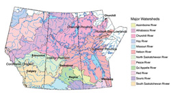
FIGURE 3: Major watersheds and the geological provinces of the Prairies.
The Prairies extend west from Hudson Bay to the crest of the Rocky Mountains, thus spanning several major climatic, biogeographic and geological zones and watersheds (Figure 3). Because of the region's mid-latitude location in the rain shadow of the Rocky Mountains, the climate is generally cold and subhumid. There are extreme differences in seasonal temperatures. During the period 1971–1990, mean temperatures in the coldest and warmest months were –7.8°C and 15.5°C, respectively, at Lethbridge and –17.8°C and 19.5°C, respectively, atWinnipeg. Mean annual temperatures are highest in southern Alberta, elevated by winter chinooks, and decrease towards the short, cool summers and long, cold winters of northern Alberta, Saskatchewan and Manitoba (Figure 4a). Annual precipitation varies considerably from year to year, ranging from less than 300 mm in the semiarid grassland to about 700 mm in central Manitoba (Figure 4b) and more than 1000 mm at high elevations in the Rocky Mountains.Throughout the Prairies, snow is important for water storage and soil moisture recharge.The wettest months are April to June.
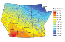
FIGURE 4a: Climate normals (1961-1990) for the Prairies: temperature.
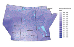
FIGURE 4b: Climate normals (1961-1990) for the Prairies: precipitation.
The temperature and precipitation patterns in Figure 4 result in annual moisture deficits in the southern and western plains, and moisture surpluses in the Rocky Mountains and foothills, and in the northern and eastern boreal forest. Most runoff is shed from these wetter regions eastward via the Saskatchewan-Nelson- Churchill river system into Hudson Bay, and northward via the Athabasca, Peace and Hay rivers into the Mackenzie River and Arctic Ocean (Figure 3). Little runoff is generated across the southern Prairies, and large areas are drained internally by intermittent streamflow.The few permanent streams in the south are thus important as local water sources.The heavy demand for water from rivers that cross the southern plains is in sharp contrast to the large rivers, countless lakes and sparse population of the northern forests and shield.
1.2 ENVIRONMENT AND ECONOMY BY ECOZONE
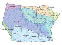
FIGURE 5: Ecozones of the Prairies.
The Terrestrial Land Classification of Canada includes seven ecozones that lie within the Prairies (Figure 5). The Prairie and Boreal Plains ecozones represent more than 50% of the area and have most of the population. The 25% of the Prairies occupied by the Prairie Ecozone is the region's agricultural and industrial heartland. It is the most extensively modified region of the country—there remain only remnants of the original mixed- and tall-grass prairie, and less than half the presettlement wetland area. The pattern of settlements reflects their original functions as regional service centres and collection points along rail lines for agricultural products. Hundreds of communities have vanished with rural depopulation, the consolidation of farms and the grain collection system, abandonment of rail lines and concentration of population, services and wealth in urban centres. TD Bank Financial Group (2005) recently reported that per capita GDP (a measure of standard of living) in the Calgary-Edmonton corridor increased by US$4 000 between 2000 and 2003 to US$44 000, 47% above the Canadian average.
The Prairies have about 50% of Canada's farms but more than 80% of the farmland (Table 4), mostly in the Prairie Ecozone. Historically, the export of grains, oilseeds and animal products has been an important source of Canada's foreign exchange. Agriculture now accounts for only a small percentage of the gross provincial GDPs relative to other industries (see Section 2.2), particularly mining and energy production. Average farm size is significantly larger in Saskatchewan (greater than 500 ha) than in the other two provinces. The Prairie Ecozone is characterized by persistent, and sometimes severe, moisture deficits. Droughts are most frequent and severe in the mixed grassland, one of the five ecoregions that constitute the Prairie Ecozone. This area is commonly known as Palliser's Triangle, because it was described as “forever comparatively useless” by John Palliser following a survey in 1857–1859. In this subregion of southern Alberta and southwestern Saskatchewan, crop and forage production is sustained by irrigation that depends on runoff from the Rocky Mountains and Cypress Hills. Irrigation is the major water use in Alberta and Saskatchewan, with Alberta having almost two-thirds of Canada's irrigated land. North of the prairie and aspen parkland, vegetation shifts to mixed and coniferous forest — there are about 97 million hectares of forest in the Prairies. The Boreal Plains Ecozone of central Manitoba, central Saskatchewan and most of central and northern Alberta was the area first visited by Europeans, since it has navigable rivers and fur-bearing animals. The boreal plains are now once again the new frontier, with large oil and gas reserves, nearly all the commercial forestry, expanding farmland in northern Alberta, and hydroelectric power plants in Manitoba and Saskatchewan. The Aboriginal peoples of this ecozone are tied to a traditional way of life, with wildlife a particularly valuable resource.
| Alberta | Saskatchewan | Manitoba | Prairies | Canada | |
|---|---|---|---|---|---|
| Number of farms | 53 652 | 50 598 | 21 071 | 125 321 | 246 923 |
| Area of farmland (ha) | 21 067 486 | 26 265 645 | 7 601 779 | 54 934 910 | 67 502 447 |
The Boreal Shield Ecozone lies north and east of the interior plains in northern Saskatchewan and northern and eastern Manitoba. Frontier resource development, particularly mining, is the backbone of the economy. Cree and Dene First Nations account for most of the population.
The remaining four ecozones are on the margins of the Prairies and account for small portions of the area and population. The Taiga Plains Ecozone extends from the Mackenzie River valley of the Northwest Territories up the tributary valleys of northwestern Alberta. The productivity of the 'taiga' forest is limited by the cooler climate and shorter growing season. The Taiga Shield Ecozone extends across Canada's subarctic, including the northern reaches of Manitoba and Saskatchewan and a small part of northeastern Alberta. Like the Boreal Shield, it is rich in mineral resources and supports the traditional livelihood of the Cree and Dene First Nations. The Hudson Plains Ecozone, adjacent to Hudson Bay in northeastern Manitoba, is dominated by extensive wetlands. Churchill is an important seaport and railway terminus. The Montane Cordillera Ecozone of the Rocky Mountains in western Alberta has high ecological diversity associated with landscapes of high relief, ranging from low-elevation fescue grassland through montane forest to subalpine forest and alpine tundra. The dominant economic activities are cattle ranching and outdoor recreation. Much of the area is designated as national and provincial parks and protected areas. Resource extraction, coal mining, forestry, and oil and gas production are increasingly in conflict with ecological and watershed conservation. Mountain snowpacks and glaciers of the Cordillera are the source of most of the river flow and water supply across the southern Prairies.
Page details
- Date modified: